In an edited extract from his new book, Danny Dorling, professor of human geography at the University of Sheffield, argues that the idea of the population bomb is a fallacy and that the human population is checking its rise without the need for a grand plan
This essay is written by a critic of Thomas Malthus and could serve as a bridge to discuss issues in a population unit and an urban unit. In a nutshell, Dorling feels that that Malthusian-like fears and assumptions about the proliferation of slums are unfounded; this is a good reading that can spark some conversation in a college seminar.
This essay is written by a critic of Thomas Malthus and could serve as a bridge to discuss issues in a population unit and an urban unit. In a nutshell, Dorling feels that that Malthusian-like fears and assumptions about the proliferation of slums are unfounded; this is a good reading that can spark some conversation in a college seminar.
"When tourists visit sub-Saharan Africa, they often wonder 'Why there are no historical buildings or monuments?' The reason is simple. Europeans destroyed most of them. We only have a few drawings and descriptions by travelers who visited the places before their destruction. In some places, ruins are still visible. Many cities were abandoned when Europeans brought exotic diseases (smallpox and influenza) which started spreading and killing people. Most of those cities lie hidden. In fact the biggest part of Africa history is still under the ground."
The issues with poverty and hunger that grip certain parts of Africa- particularly the sub-Sahara- find their roots in the utter subversion and destruction of African societies and states during the Trans-Atlantic Slave Trade and the subsequent colonization of Africa. European traders placed significant strain of existing African states during the 14th and 15th centuries, as the emergence of "slave states" and the extent of the trade completely changed the demographics of much of Africa. Labor shortages lead to technological shortfalls as well as the dissolution of many African states, as predatory states continued to destroy many civilizations and cultures. By the time that the majority of the West had banned the trade in the 19th century, the damage had already been done; many of the great civilizations of Africa had regressed or been entirely wiped out under the pressure of Europe's demand for slaves. The subsequent colonization of the continent only worsened matters for the Africans, as major hubs of civilization were captured, raided, and destroyed. Traditional societies were subjected to European influences and religion and eventually lost, and yet Europeans looked at the destruction and the lack of economic and political progress their actions had caused and blamed it on the inferiority of the Africans themselves. History has not been kind to Africa, and it is important to remember that that is not her fault. Many civilizations, cities, and states were lost as a direct result of contact with Europeans during the slave trade and the subsequent colonization of the continent.
Before European contact, Africa had a number of great urban cities. European arrival foresaw the destruction of those once grand cities. The Europeans brought diseases such as smallpox and influenza to the African continent. Those diseases would hamper the previously unexposed African population. Slavery also drained Africa of millions of people as well. Great African civilizations were brought down by these various calamities. European arrival was the death knell of the great African civilizations. Africa is still living with this legacy of destruction. Africa is the most rural region in the world, because of this legacy.
This article talks about the difficulty Muslims face during Ramadan when they are outside the middle east, specifically when they are in Sweden north of the arctic circle. This article follows a few different Muslims who have chosen different ways of fasting when sun up and sun down are not a good time table to go by. Some follow the times of their homes in the middle east, while some follow the time of Stockholm, the capitol of Sweden. The article also talked about one person who goes off of Istanbul's time because Turkey is the closest Muslim country to Sweden. Some of these people fear that they will not satisfy their god when fasting like this but others believe they have to do what they have to do.
If you follow this blog, you know that I believe effective vocabulary instruction is just about the most important instructional activity for teachers to get right. For lots of reasons. Vocabulary influences fluency, comprehension, and student achievement. How’s that for starters? In addition, a broad vocabulary is important for effective speaking, listening, reading and writing. …
Let's make "10 not 12!" a new mantra for saving our cities and towns.
[12 foot lanes] are wrong because of a fundamental error that underlies the practice of traffic engineering—and many other disciplines—an outright refusal to acknowledge that human behavior is impacted by its environment.
"Can't we all just get along?" Ethnic discrimination exists in every industrialized society in every part of the globe, the result of poverty, ignorance, hatred, and various peoples now confined to national borders that do not suit their needs. Chinese discrimination against ethnic Tibetans has long been documented and observed within the West, meeting the condemnation of much of the Western world, so it was interesting to learn about the Uighurs and their plight in Chinese society- I was unaware that China had any significant Muslim populations. To learn that Chinese government officials attempted to evict and ethnic Uighur from her apartment simply for being of her ethnicity is appalling, and something that one can only hope will stop in the future. Is America in a position to judge others for how they treat their ethnic minorities? Not at all- just look at the demographics of our prison system and our families who fall below the poverty line, or our treatment of Native Americans only 100 years ago. Such racism has long been a facet of human civilization, and it is up to us to make it a thing of our past and not of our future. Can we all get along? I hope so.
This video is a clear example of how the Uighurs and the Tibetans have been left out of the economic boom of China. China is known for being perhaps the biggest economic power in the world, the main concern is that how is it that not everyone is benefitting from the situation? These Uighurs and Tibetan minorities are suffering from the power China has. This video shows that the rural areas in the country are suffering. Some people have moved to the city but some people have stood by to there rural roots. The minorities reject the city because they get discriminized for who they are. They don't know the language, and usually would be provided with lower wage jobs. These people prefer to stay in there rural areas but it is still important to help these people but providing a better education.
this is kind of a weird situation. places like tibet have the opportunity to move to places in china with great economic opportunites, but since they are treated as different and since they have pride as tibetans and want to stay in their land, they end up staying and remaining a primarily farming country and being left out of the chinese economic boom.
On July 31st India and Bangladesh will exchange 162 parcels of land, each of which happens to lie on the wrong side of the Indo-Bangladesh border. The end of these enclaves follows an agreement made between India and Bangladesh on June 6th. The territories along the world’s craziest border include the pièce de résistance of strange geography: the world’s only “counter-counter-enclave”: a patch of India surrounded by Bangladeshi territory, inside an Indian enclave within Bangladesh. How did the enclaves come into existence?The enclaves are invisible on most maps; most are invisible on the ground too. But they became an evident problem for their 50,000-odd inhabitants with the emergence of passport and visa controls. Independent India and Bangladesh—part of Pakistan until 1971—each refused to let the other administer its exclaves, leaving their people effectively stateless.According to Reece Jones, a political geographer, the plots were cut from larger territories by treaties signed in 1711 and 1713 between the maharaja of Cooch Behar and the Mughal emperor in Delhi, bringing to an end a series of minor wars.It was partition, the division of India and Pakistan, that turned the enclaves into a no-man’s-land. The Hindu maharaja of Cooch Behar chose to join India in 1949 and he brought with him the ex-Mughal, ex-British possessions he inherited. Enclaves on the other side of the new border were swallowed (but not digested) by East Pakistan, which later became Bangladesh.
Tags: borders, geopolitics, political, India, South Asia, Bangladesh.
The images in the above article truly define how the geography of an area can not last forever. Maps are continuously changing and the border changing of Bangladesh and India is a clear example. In the map giving, we can see that there is an odd circular border forming inside of what seems or should be Bangladesh territory in the upper North of India. Because of the zigging and zagging, the border along these two country is the fifth longest in the world. It is important to understand how and why territories and regions are divided, and also the affects it has for the people in the region. Since establishing a proper border is in the works between the two countries, this will allow residents in the region, who can now choose which country to join. The overall matter is to provide a more simpler border line without a border battle.
People have been farming — and eating — a GMO for thousands of years without knowing it. Scientists have found genes from bacteria in sweet potatoes around the world. So who made the GMO?
Once again, the term GMO has been used without regard for process. We need to make sure our students have a clear understanding of what it means for a crop to be "genetically modified" now. Although I get some eyerolls, this is why I continue to include an origin of agriculture segment in every introductory class I teach..
Yes, the title is somewhat misleading (isn't that almost expected these days?), since humanity has been selectively breeding crops since the first agricultural revolution and genetic alteration can occur independent of human intervention. Humanity has always been using the best technologies available to improve agricultural practices. The term GMO though, is usually reserved for scientific, technological modifications that were unimaginable 100 years ago.
Difference between population geography and demography . , . . . . What is the difference between population geography and demography demography is the ...
History is the polemics of the victor, William F. Buckley allegedly said. Not so in the United States, at least not regarding the Civil War. As soon as Confederates laid down their arms, some picked up their pens and began to distort what they had done, and why. Their resulting mythology went national a generation later and persists — which is why a presidential candidate can suggest that slavery was somehow pro-family, and the public believes that the war was mainly fought over states’ rights.
The Confederates won with the pen (and the noose) what they could not win on the battlefield: the cause of white supremacy and the dominant understanding of what the war was all about. We are still digging ourselves out from under the misinformation that they spread, which has manifested in both our history books and our public monuments.
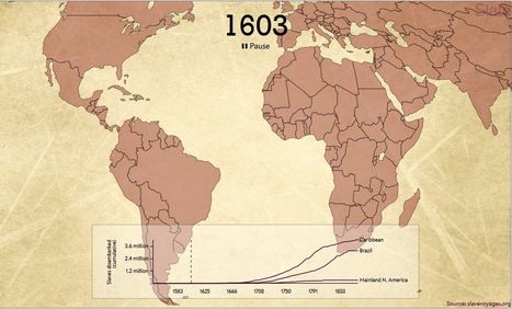
This interactive, designed and built by Slate’s Andrew Kahn, gives you a sense of the scale of the trans-Atlantic slave trade across time, as well as the flow of transport and eventual destinations. The dots—which represent individual slave ships—also correspond to the size of each voyage. The larger the dot, the more enslaved people on board. And if you pause the map and click on a dot, you’ll learn about the ship’s flag—was it British? Portuguese? French?—its origin point, its destination, and its history in the slave trade. The interactive animates more than 20,000 voyages cataloged in the Trans-Atlantic Slave Trade Database.
This is very specific teacher resource that could be useful when developing an unit plan for 'Movement of peoples (1750 – 1901)' ACDSEH018, particularly the area of study including:
Experiences of slaves, convicts and free settlers upon departure, their journey abroad, and their reactions on arrival, including the Australian experience (ACDSEH083)
The short and long-term impacts of the movement of peoples during this period (ACDSEH085)
Paired with inquiry-based questions this digital teacher resource will be a successful activity to engage learners.
"Approximately 7.1 million Americans moved to another state in 2012. That’s over 2.2% of the U.S. population. The United States has a long history of people picking up and moving their families to other parts of the country, in search of better livelihoods. That same spirit of mobility, a willingness to uproot oneself, seems alive and well today based on the visualization of migration patterns above.
The visualization is a circle cut up into arcs, the light-colored pieces along the edge of the circle, each one representing a state. The arcs are connected to each other by links, and each link represents the flow of people between two states."
Many people migrate each and every day, but sometimes when they move to places like the USA, that part of the world can become overpopulated at times. Not having enough resources many begin to slowly die off which is either a good or bad thing while being in this position. However, when people do migrate they are leaving behind their homes and many are losing jobs. ~BH
in 2012, 2.2% of the U.S population migrated to different states. I think its a good thing that people migrate to different states so they can expirience, first hand, how much states other than their home state contribute to our country. RE
Much of the population in America migrates internally, approxamitely 7.1 million Americans in 2012.The only explanation is to go for a better life in another state.
Smithsonian's History Explorer was developed by the National Museum of American History in partnership with the Verizon Foundation to offer hundreds of free, innovative online resources for teaching and learning American history.
World War II was the bloodiest conflict in human history, but it can be difficult to get a full sense of just how many lives were lost in the fighting. Data visualizer Neil Halloran set out to fix that. In a stunning presentation, he lays...
To get content containing either thought or leadership enter:
To get content containing both thought and leadership enter:
To get content containing the expression thought leadership enter:
You can enter several keywords and you can refine them whenever you want. Our suggestion engine uses more signals but entering a few keywords here will rapidly give you great content to curate.


 Your new post is loading...





















This essay is written by a critic of Thomas Malthus and could serve as a bridge to discuss issues in a population unit and an urban unit. In a nutshell, Dorling feels that that Malthusian-like fears and assumptions about the proliferation of slums are unfounded; this is a good reading that can spark some conversation in a college seminar.
Tags: declining populations, population, demographic transition model, urban, megacities, squatter.
mega cities