"Digital resources to strengthen the quality and quantity of geography education in classrooms the world over."

 Your new post is loading...
 Scoop.it! "Digital resources to strengthen the quality and quantity of geography education in classrooms the world over." 
No comment yet.
Sign up to comment
Scoop.it!

This website serves as an off-campus host for text, images, data and other web-based resources associated with the free eText, Introduction to Human Geography: A Disciplinary Approach.

Leoncio Lopez-Ocon's curator insight,
August 13, 2015 8:52 AM
Gracias a Seth Dixon accedo a este texto de acceso libre que es una interesante Introducción a la Geografía Humana. De fácil navegación se puede acceder a valiosa información textual, a imágenes, datos y otros recursos. Es un producto de Steven Graves, profesor de geografía en California State University, Northridge.
Scoop.it!

The language we speak shapes our identity and our society. So let’s celebrate the diversity of English dialects. Via Mr. David Burton
Scoop.it!

VIDEO: 5,000 years of religious history in two minutes.
Clairelouise's insight:
Short, sweet and to the point--this video is a great way to show the historical geographies of major world religions. What are the cultural barriers to the diffusion of one of these particular religions? What geographic factors helped to facilitate the expansion of one of these world religions?
Tags: religion, diffusion, culture, Christianity, Islam, Buddhism, Hinduism, Judaism,

Alexis Michelle's curator insight,
April 4, 2016 10:11 AM
Short, sweet and to the point--this video is a great way to show the historical geographies of major world religions. Each of these religions have been "born" somewhere and have grown to different countries. Everyone has a religion well most of everyone and I believe it is very important to know the history of the religion that you are or fit into. Tags: religion, diffusion, culture, Christianity, Islam, Buddhism, Hinduism, Judaism, 
Blake Bass's curator insight,
April 7, 2017 10:05 AM
This article is very excellent at explaining where religions are and why they are there,this article relates to human geography and what we are learning because it explains the most practiced religions and where they are.

Taylor Doonan's curator insight,
May 3, 2018 12:23 PM
The five major religions all growing throughout the world, rather quickly, with the exception of Judaism. Hinduism spread when it was established but quickly stopped spreading and does not span much of the world. Buddhism followed a similar path of Hinduism spreading but not going much beyond the continent of Asia, Buddhism is the largest religion in Asia and is also seen as a lifestyle and not just a religion.
Scoop.it!
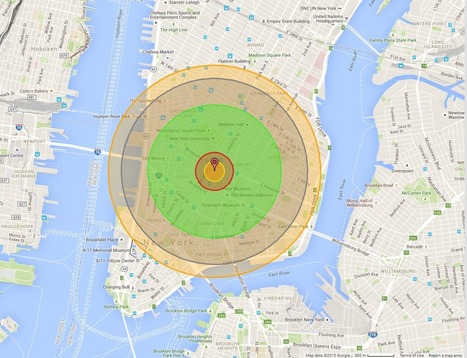
"Maps bring the horror of Hiroshima home -- literally. Alex Wellerstein, a nuclear historian at the Stevens Institute of Technology, created a NukeMap that allows you to visualize what the Hiroshima and Nagasaki explosions would look like in your hometown. Kuang Keng Kuek Ser at Public Radio International has also developed a version, using slightly different estimates. Here is what Little Boy, the Hiroshima bomb, would look like on Wellerstein's map if detonated in New York City."

Kristen McDaniel's curator insight,
August 7, 2015 11:12 AM
The NukeMap allows you to set different determinations such as bomb size, etc, as well. 
Chris Costa's curator insight,
November 25, 2015 11:48 AM
I highly suggest tinkering around with "NukeMap," as I have spent the last 30 minutes seeing how different bombs would destroy my neighborhood and the surrounding areas- it will even adjust for varying casualty rates in areas with higher or lower populations, even just by moving the detonation site a couple of streets away. It's pretty cool at the surface, but to examine the destructive capabilities of some of these weapons is downright terrifying. You view the blast radius encompassing your home, your entire existence, on a computer screen, and its easy to forget the devastation of it all disappearing. For those who survived the atomic bombs dropped at Hiroshima and Nagasaki, there was no simulation to tinker with, but instead a reality more terrible than anything I've ever had to endure in my own personal life. Thousands of lives lost, thousands more left irreversibly shattered, never to be the same again. All because men in government buildings on opposite sides of the ocean couldn't get along. No one wins in war.
Scoop.it!

"Do I wish to have paid leave myself? Of course, yes."
Scoop.it!

"Here’s a winning question for your next trivia night: Where is the world’s largest island-in-a-lake-on-an-island-in-a-lake-on-an-island? According to stories published here and here, the distinction currently goes to a nameless isle within Victoria Island in Canada’s Nunavut Territory. On August 21, 2014, the Operational Land Imager (OLI) on Landsat 8 captured this natural-color view of the “sub-sub-sub-island.” The top image shows a close-up view of the unnamed island, while the bottom image shows a wider view of Victoria Island’s lake-littered landscape (download large image here)."
Tags: Canada, trivia, remote sensing, geospatial.
Scoop.it!

The plight of elderly cardboard-collectors has become a popular topic in Singapore over the past two weeks, following a government minister's not-so-amusing gaff.
Scoop.it!

“ What does the geography of incarceration in the United States look like? (Prison Map | What does the geography of incarceration in the United States look like?”
Via Mr. Jacobsen
Scoop.it!

“ In geography, Sandspit is a landform made by the deposition of sand by the movement of tides. Spits are narrow and elongated – one end is attached to the mainland and the other is out in open water.”
Via Mr. Jacobsen
Scoop.it!

Percentage of a country's population that can read and write. Country's define literacy age between 7 and 20 years old. The standard age for literacy most countries is 15 years of age.
Tags: education, K12, development, map, worldwide.

Dee Dee Deeken's curator insight,
August 2, 2015 1:27 PM
My 10 year-old daughter was looking in our atlas a while back (yes, she is my daughter) and in the encyclopedic entry of each country she started noticing that literacy rates were included. She started asking about which regions had higher and lower literacy rates. This became a teaching moment about the power of the map--I explained that all this data can be more easily accessed and seen on a map and this interactive map is what we discovered. We need to help student find the maps and data to answer their questions (and we need to make sure that they are curious enough to ask questions about the way the world works). 
Annenkov's curator insight,
August 5, 2015 4:29 PM
My 10 year-old daughter was looking in our atlas a while back (yes, she is my daughter) and in the encyclopedic entry of each country she started noticing that literacy rates were included. She started asking about which regions had higher and lower literacy rates. This became a teaching moment about the power of the map--I explained that all this data can be more easily accessed and seen on a map and this interactive map is what we discovered. We need to help student find the maps and data to answer their questions (and we need to make sure that they are curious enough to ask questions about the way the world works). 
geographynerd's curator insight,
August 9, 2015 2:21 AM
My 10 year-old daughter was looking in our atlas a while back (yes, she is my daughter) and in the encyclopedic entry of each country she started noticing that literacy rates were included. She started asking about which regions had higher and lower literacy rates. This became a teaching moment about the power of the map--I explained that all this data can be more easily accessed and seen on a map and this interactive map is what we discovered. We need to help student find the maps and data to answer their questions (and we need to make sure that they are curious enough to ask questions about the way the world works). |
Scoop.it!

A YEAR ago a hospital in São Paulo announced that its maternity ward would henceforth only admit clients from 10am to 4pm, Monday to Friday. The message was clear:...
Scoop.it!
From
vimeo

Hit the nonfiction trail with Sheriff Yollis, Sheriff Salsich, and the rest of the Reading Round-Up.
Clairelouise's insight:
Text features
Scoop.it!
"This video forms a lively introduction to A Different View and the themes within it. A Different View is a manifesto from the Geographical Association. It makes a compelling case for geography's place in the curriculum. But the world changes, and so does the curriculum. A Different View, and the supporting materials on this website, are designed to be used in any context where geography is taught, explained, encouraged or promoted."
Tags: education, K12, geography education.
Scoop.it!

China has been feverishly piling sand onto reefs in the South China Sea for the past year, creating seven new islets in the region. It is straining geopolitical tensions that were already taut.
Clairelouise's insight:
Last year this was an intriguing story but now the geopolitical drama is growing as more countries are literally building islands out of reef outcroppings to strengthen their claims to the South China Sea. This is the most comprehensive article that I've seen on the escalating situation. Tags: borders, political, conflict, water, China, East Asia.

Benjamin Jackson's curator insight,
December 14, 2015 12:01 PM
this strategy makes sense, even if it ignores international laws and angers every other nation on earth. china needs resources, and the south china sea has resources. 
Nicholas A. Whitmore's curator insight,
December 17, 2015 4:02 PM
The fact that China is doing this in the first place is a profound geopolitical statement. They are in effect disregarding international law and acting as though they own the region. This also fly's in the face of countries in the Area such as Vietnam and the Philippines who have territorial water claims in that area of the region itself has been a matter of dispute for decades. This is partially due to the fact there is key oil and gas resources and china intends to use the islands they have made to claim and seize those deposits. trade also goes through the area making it possible for China to shut down regional trade if it gains these waters. This is a clear power display and shows China wants to supersede the U.S. not work with it. Hopefully the issue is resolved peacefully given that it has been causing heightened tensions with the Chinese Navy patrolling the area. The international community should have acted earlier to stop this because now it will be far more difficult and makes nations like the U.S. look weaker. Not to mention the vast environmental consequences for destroying reefs filled with unique wildlife thus disrupting the ecosystem. 
David Stiger's curator insight,
December 2, 2018 10:40 AM
By building man-made territory in the form of islets in the South China Sea, the nation of China has managed to assert a contentious claim of sovereignty. In this same body of water - which was formerly thought to be an open international zone - Malaysia to the South and the Philippines to the north have also staked claims via existing islands. These two East Asian countries expanded and solidified their claim by adding seabed sediment to enlarge the islands. Larger islands means more land and more space for military apparatuses like airstrips and army bases. The United States also has a vested interest in the area of the Spratly Islands because so much trade passes through these waters along with tremendous amounts of fishing and oil extraction. The South China Sea is a highly valuable location to several competing countries.
Unlike Malaysia and the Philippines, China did not build on top of existing islands but instead has repurposed fragile coral reefs as foundations to pile on dredge sediment creating entirely new islets. It is a bold move to artificially engineer land and then claim the surrounding territorial waters. China believes it possesses a historically rightful claim to the Spratly Islands within the South China Sea and is merely asserting its pre-established sovereignty. Like other rapid development moves China has launched, building artificial islands threatens the environment and biological ecosystems. The sediment and building materials, such as metal, being piled up on the coral reefs is destroying the reefs while excess material is spilling out over the ocean's surface blocking sunlight. This could severely disrupt the food-chain system as the reefs and plankton need sunlight to survive. In tandem to this harmful shading effect are oil leaks running into the water contaminating the local wildlife. Running the risk of an all-out military conflict in the South China Sea while setting up the destruction of its ecosystem means that China, despite its historical claims, is making a poor decision. If China wants to be a world leader, it needs to set a better example and employ diplomatic means to keep the Spratly Islands open and healthy.
Scoop.it!

GeoGuessr is a geography game which takes you on a journey around the world and challenges your ability to recognize your surroundings.
Clairelouise's insight:
I've shared GeoGuessr before but they now have country-specific quizzes (this is for the United States). When I was a child I used to wonder if woke up somewhere far from home, would I be able to know where I was just by looking at the places around me (I was a geo-geek from way back when). GeoGuessr is the closest thing to finding yourself lost in the world and needing to figure out where you are without being wisked away. GeoGuessr will display 5 locations in GoogleMaps "StreetView" and you have to guess where the images are located. You can pan and zoom in the StreetView to explore the landscape and find more context clues as to where that location is. It is a fantastic exploration exercise.
Tags: landscape, place, trivia.

Silvia Nascimento's curator insight,
August 9, 2015 3:06 PM
I've shared GeoGuessr before but they now have country-specific quizzes (this is for the United States). When I was a child I used to wonder if woke up somewhere far from home, would I be able to know where I was just by looking at the places around me (I was a geo-geek from way back when). GeoGuessr is the closest thing to finding yourself lost in the world and needing to figure out where you are without being wisked away. GeoGuessr will display 5 locations in GoogleMaps "StreetView" and you have to guess where the images are located. You can pan and zoom in the StreetView to explore the landscape and find more context clues as to where that location is. It is a fantastic exploration exercise.
Tags: landscape, place, trivia. 
Sally Spoon's curator insight,
August 9, 2015 4:41 PM
I've shared GeoGuessr before but they now have country-specific quizzes (this is for the United States). When I was a child I used to wonder if woke up somewhere far from home, would I be able to know where I was just by looking at the places around me (I was a geo-geek from way back when). GeoGuessr is the closest thing to finding yourself lost in the world and needing to figure out where you are without being wisked away. GeoGuessr will display 5 locations in GoogleMaps "StreetView" and you have to guess where the images are located. You can pan and zoom in the StreetView to explore the landscape and find more context clues as to where that location is. It is a fantastic exploration exercise.
Tags: landscape, place, trivia. 
Sanda Craina's curator insight,
August 10, 2015 1:11 PM
I've shared GeoGuessr before but they now have country-specific quizzes (this is for the United States). When I was a child I used to wonder if woke up somewhere far from home, would I be able to know where I was just by looking at the places around me (I was a geo-geek from way back when). GeoGuessr is the closest thing to finding yourself lost in the world and needing to figure out where you are without being wisked away. GeoGuessr will display 5 locations in GoogleMaps "StreetView" and you have to guess where the images are located. You can pan and zoom in the StreetView to explore the landscape and find more context clues as to where that location is. It is a fantastic exploration exercise.
Tags: landscape, place, trivia.
Scoop.it!

From
www
The author grew up in India, where namaste was a way of saying hello — respectfully — to his elders. In America's yoga culture, he's found, it has a very different vibe.
Scoop.it!

"So what if Ariana doesn't look like a pure-blooded Japanese? Her mom's Japanese...and she said her daughter's acclimated to Japanese culture. Ariana's an elegant Japanese woman!"
Scoop.it!

From
phys
Scholars have long been interested in tracking 'knowledge spillovers,' the way technical and intellectual advances spread among communities of researchers and innovators.
Via Mr. Jacobsen
Scoop.it!

“ Wired Geographical Distance, not Climate, Explains Regional Cuisines Wired I've written before about methods to quantify cooking and cuisine similarities.”
Via Mr. Jacobsen
Scoop.it!

Staircases are constructions designed to bridge a large vertical distances by dividing it into smaller vertical distances, called steps.
Via Mr. Jacobsen
|