History and Social Studies Education
34.4K views | +0 today
Follow
History and Social Studies Education
Resources from Rhode Island College History and Social Studies educators for the classroom http://geographyeducation.org
Curated by Seth Dixon
Your new post is loading...
Scooped by Seth Dixon
Scoop.it!

What it would look like if the Hiroshima bomb hit your city

What it would look like if the Hiroshima bomb hit your city | History and Social Studies Education | Scoop.it

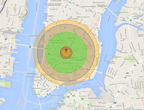
"Maps bring the horror of Hiroshima home -- literally.  

Alex Wellerstein, a nuclear historian at the Stevens Institute of Technology, created a NukeMap that allows you to visualize what the Hiroshima and Nagasaki explosions would look like in your hometown. Kuang Keng Kuek Ser at Public Radio International has also developed a version, using slightly different estimates.

Here is what Little Boy, the Hiroshima bomb, would look like on Wellerstein's map if detonated in New York City."

Kristen McDaniel's curator insight, August 7, 2015 11:12 AM

The NukeMap allows you to set different determinations such as bomb size, etc, as well.  

Adilson Camacho's curator insight, August 8, 2015 11:53 AM

Human Nature!

Chris Costa's curator insight, November 25, 2015 11:48 AM

I highly suggest tinkering around with "NukeMap," as I have spent the last 30 minutes seeing how different bombs would destroy my neighborhood and the surrounding areas- it will even adjust for varying casualty rates in areas with higher or lower populations, even just by moving the detonation site a couple of streets away. It's pretty cool at the surface, but to examine the destructive capabilities of some of these weapons is downright terrifying. You view the blast radius encompassing your home, your entire existence, on a computer screen, and its easy to forget the devastation of it all disappearing. For those who survived the atomic bombs dropped at Hiroshima and Nagasaki, there was no simulation to tinker with, but instead a reality more terrible than anything I've ever had to endure in my own personal life. Thousands of lives lost, thousands more left irreversibly shattered, never to be the same again. All because men in government buildings on opposite sides of the ocean couldn't get along. No one wins in war.

Scooped by Seth Dixon
Scoop.it!

Kent State: Past and Present

Kent State: Past and Present | History and Social Studies Education | Scoop.it

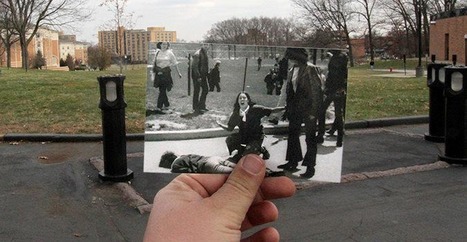
On May 4, 1970, the Ohio National Guard gunned down Jeffrey Miller, Allison Krause, William Knox Schroeder, and Sandra Scheuer during an anti-war protest at Kent State University.

Maegan Anderson's comment, May 7, 2013 12:37 AM
speechless...
Kristen McDaniel's curator insight, May 10, 2013 9:39 AM

Photos like this that juxtapose the original photograph to present day surroundings always grab me.  What an interesting discussion this could be in a history classroom!

Francisco Javier 's curator insight, May 12, 2013 8:52 PM

Kent State: Past and Present | @scoopit via @APHumanGeog http://sco.lt/...

Scooped by Seth Dixon
Scoop.it!

Ghosts of War

Ghosts of War | History and Social Studies Education | Scoop.it
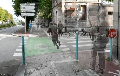
The remarkable pictures show scenes from France today with atmospheric photographs taken in the same place during the war superimposed on top.


In this fastinating set of images, Dutch artist and historian Jo Teeuwisse merges her passions literally by superimposing World War II photographs on to modern pictures of the where the photos were originally taken.  This serves as a reminder that places are rich with history; to understand the geography of a place, one must also know it's history (and vice versa).   


Tags: Europe, war, images, historial, place

Cam E's curator insight, February 27, 2014 11:26 AM

I'm not even sure what to say about this set of pictures exactly, except that they're a very cool way to see history. I'm interesting in Social Studies and history because I'm captivated by seeing the world framed in a story, and these images do just that. To see the same places where the war was fought and what has changed is great, but these photos also give the impression of some stories of war. The idea of them being "ghosts" gives the impression of something left behind which marks the land even to this day.

Samuel D'Amore's curator insight, September 10, 2014 2:56 PM

Very interesting, I've seen similar things done with Russian cities and parts of the Ukaranian country side.

Wilmine Merlain's curator insight, December 18, 2014 2:47 PM

This Dutch historian does a great job at interweaving places that were ridden by the second world war to its modern reconstruct. As a child, I use to question a lot what a place looked like prior to it being destroyed. In the context of Europe a continent, ridden by war, the historian not only does a great job at depicting past and present, her photographs also show how the country's government went to great lengths to preserve some of its land's historic sites.

Scooped by Seth Dixon
Scoop.it!

NCSS: War and Terrorism

NCSS: War and Terrorism | History and Social Studies Education | Scoop.it

The resources tab of the National Council for Social Studies (NCSS) webpage is a treasure trove of lesson plan materials for teachers. This particular link focuses on War and Terrorism, and provides resources to help teachers to educate their classes about the emerging geopolitical landscape. This is a set of over 30 lesson plans, articles, maps and resources that focus on the U.S. war in Iraq, terrorism, and other military incursions in the Middle East. Collectively they give geographic perspective on current events so students can understand more about the places in the world that they hear about in the news.

Kenny Dominguez's curator insight, November 29, 2013 4:24 PM

This must be a great teaching plan so students can be thought about what is going on in the world. It also shows them what is going on in Iraq and in the Middle East and it could probably trigger one of them to fight back and change the Middle East from all the discrimination towards women and probably destroy all these bad groups that just have a motive to destroy and kill.

Lauren Sellers's curator insight, May 29, 2014 10:34 AM

Before 9/11 a lot of Americans didnt know much about the war on terrorism, It wasnt till after the attacks when they were directly affected did they bother to learn more about it to know why it happened and if something like it would happen again. 

Max Minard's curator insight, May 26, 2015 8:32 PM

This article brings up the topic of educating students on the major topics of current political affairs and serious terrorist incursions in the Middle East and other parts of the world. As it says, it contains 30 lesson plans that all focus on providing resources and factual information on current events that involve US war in Iraq and terrorism. I personally think that this course will successfully provide students with a better knowledge on what's actually happening around them. This can further lead them to knowing how to handle these situations in the future, where they must lead the United States. It will better prepare them for future roles in government.  

Scooped by Seth Dixon
Scoop.it!

War and Terrorism

War and Terrorism | History and Social Studies Education | Scoop.it

The resources tab of the NCSS (National Council for Social Studies) webpage is a treasure trove of lesson plan materials for teachers.

This particular link focuses on War and Terrorism, and provides resources to help you teach your class about the emerging geopolitical landscape.

No comment yet.
Scooped by Seth Dixon
Scoop.it!

Re-examining the Battle of Gettysburg with GIS

Re-examining the Battle of Gettysburg with GIS | History and Social Studies Education | Scoop.it

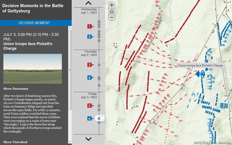
"GIS has given us the chance to re-examine how the Civil War battle was won and lost." 

Seth Dixon's insight:

July 1-3 mark the 150th anniversary of the Battle of Gettysburg, and it seems only appropriate to share these rich, interactive resources to commemorate the event (this particular interactive feature uses an ESRI storymap template).  This fantastic example from the Smithsonian Magazine shows how history teaching and research can be benefited by using GIS with the example of Gettysburg.  Many student today visit the sites of the Battle of Gettysburg and get a greater appreciation of battle by getting a sense of the lay of the land and the  challenged confronting both armies.  National Geographic has additionally put together resources to made out other Civil War battles.  GIS is not a tool that is just for geographers; any analysis that requires spatial analysis can be mapped. 


Tags: historicalwar, landscape, spatial, GIS, ESRI.

Todd Pollard's curator insight, February 4, 2014 10:34 PM

I really like this interactive map application.

Courtney Barrowman's curator insight, August 28, 2014 1:13 PM

unit 1

Rich Schultz's curator insight, November 18, 2014 3:14 PM

Just another of the millions of uses for GIS...

Scooped by Seth Dixon
Scoop.it!

The Conflict in Syria

The Conflict in Syria | History and Social Studies Education | Scoop.it

Brown University's Choices Program has many excellent resources for social studies teachers including "Teaching with the News."  Many teachers are seeing the importance of Syria, but might lack the regional expertise to put it in context or to the time to link it with the curriculum.  If that is the case (and even if it is not), this is the perfect place to find lesson plans on the ongoing Syrian conflict. 


Tags: political, MiddleEast, conflict, war.

No comment yet.
Scooped by Seth Dixon
Scoop.it!

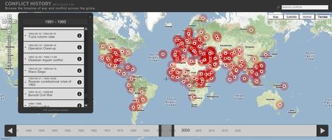
A History of Conflicts

A History of Conflicts | History and Social Studies Education | Scoop.it
Browse the timeline of war and conflict across the globe.


This database of global wars and conflicts is searchable through space and time.  You can drag and click the both the map and timeline to locate particular battles and wars, and then read more information about that conflict.  This resource would be a great one to show students and let them explore to find what they see as interesting.  This site is brimming with potential.     

olsen jay nelson's comment, August 16, 2012 7:46 AM
This is just what I've been looking for, believe it or not:-)
Sakis Koukouvis's comment, August 16, 2012 8:06 AM
Oh... You are lucky ;-)
Paul Rymsza's comment, August 22, 2012 2:15 PM
the potential of this site is amazing between the interactive learning system and the correlation between the timeline and location. If the human geography class is anything like this i can't wait for it!
Scooped by Seth Dixon
Scoop.it!

The United States in Afghanistan

The Afghanistan War has become one of the longest in U.S. history. United States military forces entered Afghanistan in late 2001, a few months after the September 11 terrorist attacks.


Associated with this video clip is a set of seven lesson plans in a unit about the United States War in Afghanistan. Find the lesson plans with supplemental materials (graphic organizers, maps, photos, etc.) for a unit on The Afghanistan War at the Choices Program webpage: http://choices.edu/resources/detail.php?id=202

No comment yet.