


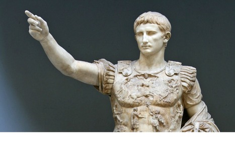

2000 years ago today, the Roman Emperor Augustus died. His reign marked the start of a 200-year period of peace and prosperity for the empire.
Via Seth Dixon

 Your new post is loading...
 Scoop.it! 2000 years ago today, the Roman Emperor Augustus died. His reign marked the start of a 200-year period of peace and prosperity for the empire. Via Seth Dixon 
Scoop.it!

"Islamic State's capture of the Mosul dam gives it control over the water and electricity supply in northern Iraq."

Nicole Kearsch's curator insight,
October 30, 2014 10:00 PM
This is interesting, ISIS is not only using brute force as a scare tactic, but are also taking hold of natural resources as well. In taking over the dam ISIS has control of not only a majority of Iraq's water supply but their power supply as well. They are also threatening employees with loss of pay to do what they want. Closing off some parts of the dam is preventing water to get to people who are in need. If the dam was to get backed up too much it could have immediate failure creating a devastating flood wiping out areas of agriculture having the potential for mass civilian casualties. ISIS is not just taking over everything that they can, but have a method to what they are doing. 
Kendra King's curator insight,
April 27, 2015 8:14 PM
As the director of the Brookings Institution's Doha Centre in Qatar said, "There's a method in their madness. By gaining control of the area ISIS can flood and destroy homes within the region. Furthermore, they can disrupt the flow of electricity and how the land is irrigated. All of this could cause a great deal of damage to the society. In this light the dam is a pretty important part of Iraq. The fact that ISIS Manipulated he land to their benefit it highly intelligent. However, if the dam was in the hand of the United States, the area still isn't completely safe. people would perceive it to be because ISIS would no longer be threatening to use it as an immediate weapon. However, the author noticed that the dam needs constant maintenance and is built on unstable soil. Both of which can cause flooding. In fact, the "worst case scenario" would cause far more damage than ISIS has with the dam. Clearly, purposefully using the resources of an area to damage a population is more chilling the a poorly made structure because malice involved. However even in the hands of the United States, the dam shows just how dangerous manipulating nature can be on a local population. 
Gene Gagne's curator insight,
November 4, 2015 5:21 PM
This will have an enormous impact on drought for drinking, agriculture purposes or even the opposite. This strategy could be used to flood the lands ruining agriculture.
Scoop.it!

Ten historians from 10 countries give a brief history of the first world war through a global lens. Using original news reports, interactive maps and rarely seen footage, including extraordinary shots of troops crossing Mesopotamia on camels and Italians fighting high up in the Alps, the half hour film explores the war and its effect from many different perspectives. Watch the documentary in English, French, German, Italian, Spanish, Arabic or Hindi. Via Seth Dixon
Scoop.it!
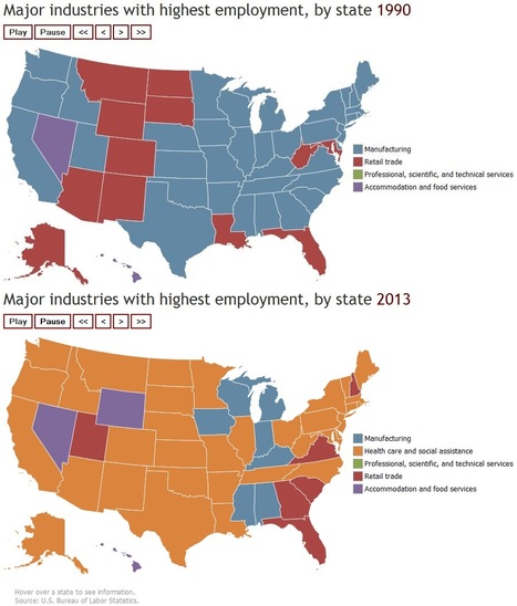
In 1990, the manufacturing industry was the leading employer in most U.S. states, followed by retail trade. In 2003, retail trade was the leading employer in a majority of states. By 2013, health care and social assistance was the dominant industry in 34 states. This animated map shows the top industry in each state and the District of Columbia from 1990 to 2013.

Lora Tortolani's curator insight,
February 2, 2015 6:49 PM
It's amazing to see how priorities have shifted over time. Also, this is a great display of how technology has taken over what once was human labor. 
Alex Smiga's curator insight,
March 14, 2016 7:43 PM
Shifting economies. This interactive map is a powerful way to visually display the changes in the economic geography of the United States. It is especially useful when discussing the transition of an economy from the secondary sector to tertiary sector. 
Olivia Campanella's curator insight,
September 5, 2018 5:02 PM
Over the years the United States has shown a number of leading employer industries. In the 1990"s the manufacturing industry was the leading employer in most United States, followed by Retail Trade industries. In 2003, Retail Trade was the leading employer, but by 2013 health Care and Social Assistance was dominant industries in 34 States. From the 1990"s to 2013 employment has been on a steady decline while Health Care and Social Assistance became largest industries in New York (1992) and North Dakota (1995).
Scoop.it!

400+ interactive maps of world stats for all countries in various domains – economy, education, environment, health, ICT and more. Powered by StatPlanet.
Scoop.it!
Clairelouise's insight:
Best way to use professional development money!
Scoop.it!

FRONTLINE explores how the perennial teen quest for identity and connection has migrated to social media – and how big brands are increasingly co-opting young consumers’ digital
Scoop.it!
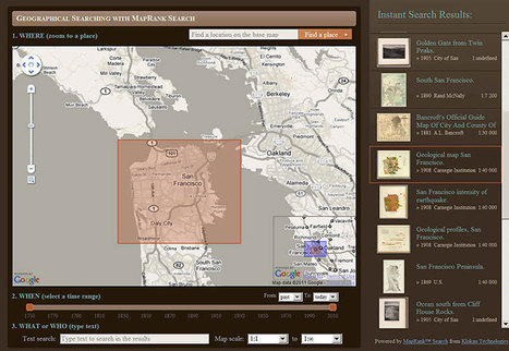
Welcome to the David Rumsey Map Collection Database and Blog. The Map Database has many viewers and the Blog has numerous categories. The historical map coll...
Scoop.it!

Hal Hayes' Cold War bomb shelter,1953. Using the pool as a decontamination space! California architecture http://pic.twitter.com/4gLw17tC17 ; Via Seth Dixon

Seth Dixon's curator insight,
June 17, 2014 12:02 PM
This picture has some cool vintage artwork to demonstrate innovative technology that was being use to create as a secret lair that when I was a boy would've been the envy of the neighborhood. Yet, underneath this campy image is a profoundly tense geopolitical situation that was driving such schemes. The image is both playful and ominous.

Yvonne Pierce's curator insight,
July 13, 2019 10:25 PM
Very insightful for analyzing the small scale compared to a large scale. Questions to ponder through analyzation - why does the population pyramids display in this manner? What critical components can be attributed to higher male/female population or higher/lower carrying capacity? Compare and contrast the pyramids of the local vs. national, perhaps even across the world at the same latitude or climate zone...
Scoop.it!

The possible departure of Scotland from Britain raises all kinds of esoteric questions about the United Kingdom’s banner. (If Scots vote to secede, could the Union Jack come down - or be redesigned? Via Mr. David Burton
|
Scoop.it!

journi is the easiest way to record your trips offline and on the go. It even lets you keep your friends in the loop without extra effort. And it’s free. Via Nik Peachey

The Teacher's curator insight,
August 18, 2014 2:16 PM
Nik Peachey's insight:
This looks like a really nice free tool to use with students to get them blogging about trips and holidays. Nice that it also works offline. 
Mirta Liliana Filgueira's curator insight,
August 18, 2014 6:41 PM
Viajes Blogging. Grabar tus viajes fuera de linea. 
Marianthe Loucataris's curator insight,
August 30, 2014 7:42 AM
This looks good as a student blogging tool for excursions or holidays..
Scoop.it!

Her family said they were going on a vacation. But Nimco Ali was taken to a woman who performed genital mutilation. Now Ali is helping the more than 100,000 girls in the U.K. possibly at risk.
Scoop.it!
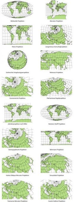
Elizabeth Borneman explores how cartography and cartographic projections help and hinder our perception of the world. "How do you think the world (starting with our perceptions) could change if the map looked differently? What if Australia was on top and the hemispheres switched? By changing how we look at a map we truly can begin to explore and change our assumptions about the world we live in."
Geography doesn’t just teach us about the Earth; it provides ways for thinking about the Earth that shapes how we see the world. Maps do the same; they represent a version of reality and that influences how we think about places.
Tags: mapping, perspective.

samantha benitez's curator insight,
November 22, 2014 2:53 PM
helps show the different perspectives of our world and how it has changed. also shows many different forms of mapping our world throughout time. 
Emily Coats's curator insight,
May 27, 2015 10:34 AM
UNIT 1 This article discusses map projections and how they shape our perception of the world. Maps influence how we see the world, and could change the way we see it as well. These projections show us many different views of the Earth, which is very influential to our perspectives. This applies to unit 1 and its major concepts and underlying geographical perspective such as analyzing maps.
Scoop.it!

Wearing of headscarves and niqabs also banned from public buses for security reasons in city in Muslim-majority region. Via Mr. David Burton
Scoop.it!

Students and alumni from a Richmond-area high school are seeking to revive the school’s historic mascot, a Confederate soldier known as the “Rebel Man,” spurring debate about the appropriateness of public school connections to the Civil War and its... Via Seth Dixon
Scoop.it!

It's the most effective anti-poverty program in U.S. history. So why do some people hate it?
Scoop.it!

Media and culture expert dana boyd says kids are finding their own ways to navigate our digital world.
Scoop.it!
The National Archives Digital Classroom: Primary Sources, Activities and Training for Educators and Students.
Scoop.it!

Writer Tarek Osman traces many of the current problems in the Middle East to the secret Sykes-Picot agreement of 1916
Scoop.it!

Published in 1941, this “Trading Game: France—Colonies” aimed to teach French children the basics of colonial management.
Players drew cards corresponding to colony names, then had to deploy cards representing assets like boats, engineers, colonists, schools, and equipment, in order to win cards representing the exports of the various colonies. “Images on the game,” Getty Research Institute curator Isotta Poggi writes in her blog post on the document, “provide a vivid picture of the vast variety of resources, including animals, plants, and minerals, that the colonies provided to France.” Cartoons on the cards depict coal (mined by a figure clearly intended to be a “native”), rubber, wood, and even wild animals. Via Seth Dixon
Scoop.it!

This map prefaced a 1919 book by the United States Food Administration, titled Food Saving and Sharing: Telling How the Older Children of America May Help Save From Famine Their Comrades In Allied Lands Across the Sea. “Remember,” the text asked its readers, “that every little country on the [map] is not merely an outline, but represents millions of people who are suffering from hunger." Via Seth Dixon

Stephen Zimmett's curator insight,
August 6, 2014 3:02 PM
An interesting story about the Germans:n France “the Germans set to work deliberately to do as much harm as possible,” destroying fruit trees and vineyards; they poisoned wells and burned houses.
Scoop.it!

We’re sort of led to believe that the ‘best’ search results are the ones on the first page. Companies pay tons of money to be featured on the top of the search results for this reason! Don’t be fooled – it is worth the time you spend sifting through the search results.
Via Nik Peachey

Julie Lindsay's curator insight,
July 29, 2014 6:44 PM
A good places to start your research thinking...... 
Training in Business's curator insight,
July 30, 2014 6:19 AM
How To Become A Better Online Researcher |







While some internet map compilations aren't that informative, Vox puts together some quality sources in a way that add perspective and insight to any given topic. This collection on the Roman Empire gives today's students maps with perspective to see the size of the Roman Empire as well as maps to show the cultural and historic context.