


A demonstration of an interactive map of places throughout my neighbourhood that are culturally and linguistically diverse.
Via Brianna Waddell
Get Started for FREE
Sign up with Facebook Sign up with X
I don't have a Facebook or a X account


 Your new post is loading...
 Your new post is loading...
Your new post is loading...
A demonstration of an interactive map of places throughout my neighbourhood that are culturally and linguistically diverse. Via Brianna Waddell 
Catherine Smyth's insight:
Explore this online map of Australia in 1798-1803 in the time of Matthew Flinders.

Nerolie Callaghan's curator insight,
October 23, 2015 8:50 AM
Very interesting maps of early Australia.
Infographic: “In Charted Waters – Mapping a Brave New World” | Larry Ferlazzo’s Websites of the Day…
Catherine Smyth's insight:
This is an interactive map and infographic that traces the history of world exploration.

A country's most popular hygiene product has a lot to do with its demographics. Via Seth Dixon, Catherine Smyth

Catherine Smyth's curator insight,
January 23, 2014 8:42 PM
This topic would appeal to many primary children!
Catherine Smyth's insight:
A picture paints a thousand words. The images on this blog inspire and invoke.
Edward Tufte home page for books, posters, sculpture, fine art and one-day course: Presenting Data and Information
This module looks at the connections between Australian companies and organisations and countries in the Asia region.

Catherine Smyth's insight:
Create interactive thematic maps to show data.
Use Plug and Play Maps to create your interactive thematic map and legend automaticallywork with your data in many formatsmap as many datasets as you like - each one gets its own appearance, legend, and control

Rosie Peel's curator insight,
June 8, 2013 8:06 AM
As the name implies, the whole point of Plug and Play Maps is to make it as simple as possible to put maps on your web pages. There are just two quick steps you need to take to get your maps going. Once you have your maps in place, you may want to explore the How To topics to learn about more easy ways to enhance the appearance and usefulness of your maps. Happy mapping!
What’s Your ECOpedagogy?Environmental Education with Mobile Devices - Paul Kelba Calgary Board of Education ISTE 2013 Via John Evans
Catherine Smyth's insight:
This slideshare presentation highlights a range of geographical tasks that can be enhanced using different mobile technologies. Great ideas for data collection, recording and organising information on fieldtrips using mobile devices.

Roimata Baker's curator insight,
July 1, 2014 3:48 PM
He hononga a te ao matihiko ki te mahi tiaki taiao.
This module looks at the countries found in the Asia region and explores a range of places in China, Japan, India and Indonesia that are special to the people who live there.
Catherine Smyth's insight:
A useful K-2 teaching resource aligned to the Australian Curriculum:geography
This module is about how Cambodian people have adapted to seasonal floods. Students collect images about the Tonle Sap lake and inhabitants daily lives and write a day in the life diary.
Catherine Smyth's insight:
A teacher-friendly resource aligned to the Australian curriuclum:geography.


Maree Whiteley's curator insight,
May 31, 2013 4:36 AM
Fabulous toolbox of resources... thanks AGTA!

Sandra Davies's curator insight,
May 15, 2020 8:09 AM
Secondary learning plans for geography lessons
Catherine Smyth's insight:
What does this place look like, sound like, smell like, feel like?
|

With Earth Day 2014 coming up on April 22, many schools are making plans for one-day celebrations that promote a green message. For deeper learning --and longer-term benefits for people and planet ali
Catherine Smyth's insight:
Planning resources and ideas for designing Project-Based Learning projects.

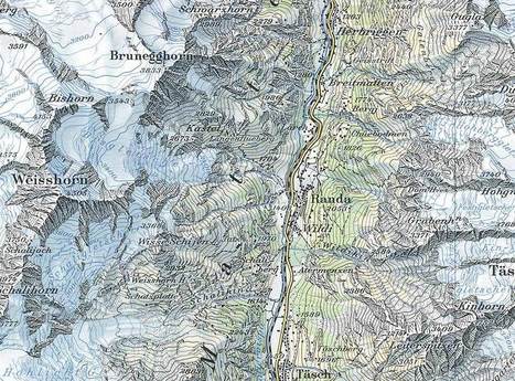
The State Library holds one of the most significant collections of maps in Australia, reflecting changes in cartography from the earliest charts of European navigators to digitally created maps of the twenty first century.
Catherine Smyth's insight:
It is easy to get lost in this amazing world of digital and interactive collection of maps.

If you were to re-draw the map of the world according to each country's population, you would get a warped world that looked like this.

"The Great Circle Mapper displays maps and computes distances along a geodesic path. It includes an extensive, searchable database of airports and other locations."

Caterin Victor's curator insight,
January 15, 2014 7:45 AM
The distance, depends : by map or by airplane !! 
Jessica Rieman's curator insight,
January 28, 2014 12:59 PM
Because this route from JFK Airport to SYD AUS Airport is not a straight route there are many factors that need to be taken in account because of the overwhelming idea of trade winds and how that affects flight plans and routing for different airways/airlanes. The plane has to fight against the trafe winds in order to create a specific ETA for the passenger and the flight crue among the plane. This is all dependent upon the trade winds (prevailing and other kinds) transmitting against the plane.
An Urban World: UNICEF's new data visualization of urban population growth over the next 40 years.
Catherine Smyth's insight:
Resources for embedding a global perspective into teaching.
Catherine Smyth's insight:
For primary teachers without a disciplinary background in geography, this keynote by Seth Dixon provides an overview of geographical concepts, skills and pedagogy. Some of this content can be adapted for primary learners but it's more about the BIG IDEAS in geography that will help frame teaching and learning. Check out the ACARA Shape Paper:geography as well.

There will be lots of outdoor activities going on this term as the summer holiday draws near. The Guardian Teacher Network has resources to help teachers develop outdoor learning throughout the year
Catherine Smyth's insight:
Ideas for teaching and learning beyond the classroom.

This module looks at country-specific data and interactive maps and graphs to achieve an appreciation for the diversity of the countries that make up 'Asia'.
Catherine Smyth's insight:
This is an inquiry-based UOW focusing on Year 6.
This module looks at housing and shopping in Indonesia through the eyes of a young Indonesian boy, Devon. Students will gain insight into the diversity of life in Indonesia through Devon’s story.
Catherine Smyth's insight:
A useful teaching resource aligned to Year 3 Australian curriculum: geography.
GeoGuessr is a geography game which takes you on a journey around the world and challenges your ability to recognize your surroundings.
Catherine Smyth's insight:
A slightly addictive, fun and interactive geography game.
Catherine Smyth's insight:
With the imminent implementation of the Australian Curriculum: geography in K-6 there is a great need for Australian- based classroom research in this area. This article by Simon Catling, a UK researcher, explains the role and value of classroom research and outlines a range of techniques for conducting research. Catling offers four different ideas for classroom research in geography including: 1. Children's ideas about geography 2. Teachers' strategies for developing children's enquiry questions 3. Children's geographical images and knowledge 4. 'Mapping' approaches to planning in geography
|


![Digital Collections - Maps - Flinders, Matthew, 1774-1814. General chart of Terra Australis or Australia [cartographic material] : showing the parts explored between 1798 and 1803 by M. Flinders Co... | Primary geography | Scoop.it](https://img.scoop.it/0Q5u2pgD3W1BDto1QdVwnjl72eJkfbmt4t8yenImKBVvK0kTmF0xjctABnaLJIm9)


Zee Maps: Our Neighbourhood
Maps, globes and models are excellent classroom resources because they portray a vast amount of information and present students with opportunities to explore the world around them (Marsh, 2010, p. 241). The Zee Maps website allows users to create interactive maps which can be embellished by adding images, videos and/or audio.
Whilst ‘maps’ are typically used in the Environments strand of HSIE (Board of Studies, 2006, p. 47), this resource provides opportunities for teachers to link Cultures content to the local environment through visually depicting the cultural and linguistic diversity of the local community. An example of how this could practically work in a classroom could be to map parks, streets, restaurants, shops etc that have a linguistically diverse (not entirely English) name. Ideally, in older years a homework task could involve students finding one local ‘place’ with a non-English name and recording it by taking a photo, recording its name and location, or collecting a pamphlet/take away menu from the ‘place’. In ES1, the teacher could take on this role by finding several linguistically diverse ‘places’ and pinning them on an interactive Zee Map prior to the lesson (the link embedded in this scoop is an example I created). The lesson would involve discussions about the linguistically diverse words and their origins, meanings, similarities to English words etc.
References:
Board of Studies NSW. (2006). Human Society & its environment. Sydney: Author.
Marsh, C. (2010). Becoming a teacher: Knowledge, skills and issues. French's Forest: Pearson.