Follow, research and publish the best content
Get Started for FREE
Sign up with Facebook Sign up with X
I don't have a Facebook or a X account
Already have an account: Login

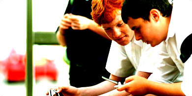
Primary geography
4.2K views |
+0 today


 Your new post is loading...
 Your new post is loading...
Your new post is loading...
"My 2015 NESTVAL presentation in an APHG session on the geography of food." 

GTANSW & ACT's curator insight,
October 10, 2015 6:09 PM
Things to consider when teaching about food production from a geographical perspective - remember to link to Biomes.

As food waste returns to the headlines, we pull together some stories, lesson ideas and links that you won't want to throw away

Hannah Morton's curator insight,
September 4, 2015 10:59 PM
Collections of resources for each grade to support the implementation of Asian perspectives, and the new Geography Syllabus for the Australian Curriculum.
Create a map from location list, crowd source, spreadsheets, etc. Publish, share interactive maps. Mapping of radius, administrative, and other regions. Map images.
Are you looking for a way to teach your children or students geography? Offer them a totally free vacation around the world by downloading the following Free iPad apps. Let them see the location, heritage and beauty of each country just by tapping your fingers.

Molly Rose's curator insight,
September 23, 2015 1:42 AM
Attention all tech-savvy teachers!!! This list of free apps will allow for a student-centered classroom to be created. Some notable apps include UN CountryStats app and StuckOnEarth- easily implemented into the stage 3 classroom when looking at 'a diverse and connected world' (see link below to NSW Syllabus).
http://syllabus.bos.nsw.edu.au/hsie/geography-k10/content/1184/
Remember to trial these apps yourself before handing over to the students.

Shannon O'Reilly's curator insight,
May 14, 2015 6:55 AM
Evaluation of the resource as an effective teaching tool: This website provides an interactive timeline for students to explore the history of waste. It dates back to pre-colonisation in its exploration of Australia’s waste production and the ensuing steps taken to manage it. Students can use their investigative skills to gather information and highlight key ideas about the introduction of laws and regulations over time.
Syllabus links: This resource links with ENS2.6 as it describes people’s interactions with environments and identifies responsible ways of interacting with environments. The specific indicators it addresses are: “examines some regulations, laws and practices associated with the management and care of natural and built features and sites” and “examines the advantages and disadvantages of various land uses”. (Board of Studies, 2007, p.33).
Pedagogy: Since there are a number of events on the timeline, students (or groups of students) will become experts in one event and report back to the class on its defining features. As such, students will become specialists; enabled by a narrowed scope that allows them to sort information effectively without being overwhelmed. When students report back to the class, they will have guiding inquiry questions on the board to follow such as; compare and contrast events, infer information about gaps and silences in the timeline and evaluate the effectiveness of laws and regulations. The class will briefly hypothesise and brainstorm around “where to from here” which is a front loading activity to help students in their literacy assessment. Encouraging students to think about their thinking (compare and contrast, etc) will allow them to reflect on what strategies they used to decipher and organise the information, and how to improve on this (Gilbert & Hoepper, 2014, p.86).
Activity and Assessment: Students will extrapolate the timeline and write a diary entry from the perspective of their older self in 2020 and 2050 with reference to future waste management issues/systems they think would best address the needs of the growing population, shortage of space and health and hygiene concerns. Students can seek inspiration from the video gallery under the Waste Heroes tab.
References:
Board of Studies Teaching and Education Standards NSW. (2007). Human Society and Its Environment (HSIE) K-6 Syllabus. Board of Studies, NSW.
Gilbert, R., & Hoepper, B. (2014). Teaching Humanities and Social Sciences: History, Geography, Economics & Citizenship in the Australian Curriculum (Fifth Ed.) Australia: Cengage Learning
Hannah Morton's curator insight,
August 5, 2015 4:49 AM
Great website to support teaching of sustainability. - Can be easily linked to HSIE, English and Science!

Students look at lines of latitude and longitude on United States and world maps, discuss why these lines are helpful, and identify landmarks with similar latitude and longitude. Via Ruby Kerr

Ruby Kerr's curator insight,
April 12, 2015 5:49 AM
The ‘Introduction to Latitude and Longitude’ resource developed by National Geographic provides a template for teachers to follow when teaching students the geographical terminology of longitude and latitude. The publication provides structure for a lesson as well as handouts, background information and terminology used. Although this source has a focus on America it can also be adapted for Australia and other countries.
Placing the map provided in the resource on the interactive whiteboard in front of the whole class allows the teacher to model how to find points on a map/ how to describe the position of marked points. Activities could also follow asking a student to describe a location and one of their peers having to find it on the map. This would assess students understanding of geographical terminology specifically latitude and longitude.
As ‘Children construct their own understanding through interaction with their environment’ (McInerney & McInerney, 2010, p. 36), developing activities that are student centered will effectively allow them to be completely immersed in learning geographical terminology. Using this activity but changing the map to be a location which the students are familiar with, e.g. the school, NSW, a theme park and asking for points to be located on that map may also increase enjoyment and engagement in the activity. Teachers must scaffold the construction of knowledge and make explicit connections between prior knowledge and new learning. This activity also involves elements of numeracy as students are required to recognise numbers and how to determine points on a map (MA2-17MG).
References Board of Studies Teaching and Educational Standards NSW. Working Mathematically. Retrieved March 26, 2015 from http://syllabus.bos.nsw.edu.au/mathematics/mathematics-k10/outcomes/
National Geographic (n.d). Introduction to Latitude and Longitude retrieved from http://education.nationalgeographic.com.au/education/activity/introduction-latitude-longitude/?ar_a=1
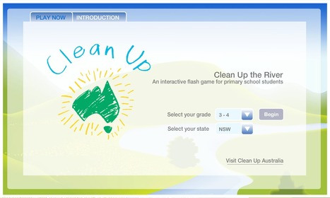
In our daily lives, we deal with the natural environment at home, schools, parks and all public places. As people, starting from young age we interact with the environment. Thus, from young age it is important that little things such as taking care of our local environment is an essential learning criteria. The interactive and curriculum based learning resource provides students with fundamental skills to facilitate their application in everyday situations even beyond school to create a better environment. Via Andrew Seong Min Park

Andrew Seong Min Park's curator insight,
April 12, 2015 6:54 AM
The interactive flash game by Clean up Australia provide student effective resource with visual and audio cues to enhance student learning on waste disposal and management. It provides enjoyment in learning to process information easier through multiple means of representation (CAST, 2012). And with the change in technology and methods of teaching pedagogy, interactive games such as this provides an effective cue to deliver teaching in education and provide effective learning.
A teaching idea:
Depending on the technological resources and the amount of resources available, a lesson can be conducted in a computer lab or on Ipads where students work individually or in pairs. By implementing interactive flash games it allows students to deepen and consolidate their understanding in the importance of waste disposal and its effects through visual and sound. In interactive flash games further teaches students how to manage waste disposal, but learn the effects it has on the environment. Explain to students that - First part of the interactive flash games is about collecting appropriate waste and observe what belongs and does not belong in our environment - Second part is students learn for themselves to identify sorting waste in disposal bins to help our environment.
Activity:
Students return back to their classroom and present three disposal bins labelled and colour coded as follows: Red: General Waste Blue: Paper recycling Yellow: Plastic and Aluminium containers The colour of the bins provide a fun way for students to identify and learn to adopt to appropriate waste disposal behaviours and identify responsible ways to interact with their local environment.
Reference
CAST. 2012. National Center On Universal Design for Learning. At CAST. Retrieved on 10th April 2013 fromhttp://www.udlcenter.org/aboutudl/whatisudl
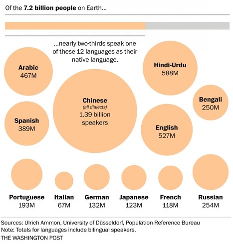
"These seven maps and charts, visualized by The Washington Post, will help you understand how diverse other parts of the world are in terms of languages." Tags: language, culture, infographic.

Caitlyn Christiansen's curator insight,
May 26, 2015 10:35 AM
The world is extremely diverse in its spread of native languages. Yet only a handful are commonly spoken by the majority of the world, about 2/3. Over half of the world's languages are expected to go extinct because of the extreme diversity and the minimal distribution which means that in some places almost every person speaks a completely different language and many are dying as their last speakers do not pass it on to their children.
This article is relates to cultural patterns and processes through the geographic spread of languages around the globe and the increasing acculturation that causes the loss of many of these languages in our increasingly globalized world. 
Michael Amberg's curator insight,
May 26, 2015 10:35 PM
Its interesting to see just how many people speak the languages we speak everyday, and to see just how many people DONT speak it. 
Shane C Cook's curator insight,
May 27, 2015 5:34 AM
It is amazing to see all main languages in perspective to the world. Mandarine holding the top spot with 1.39 Billion surprises me but at the same time doesn't. There are 1.3 billion people living there in the first place.
Reading from the book "There's a Map on My Lap!: All about Maps" by Tish Rabe, Aristides Ruiz (Illustrator) From the Cat in the Hat's Learning Library Voice:... Via Dave Baker

Dave Baker's curator insight,
April 13, 2014 5:46 AM
To introduce the idea of a globe, it's important to first introduce the whole concept of mapping; that geographical information from reality can be simplified and scaled down in order to be accessible and useful for a specific audience. It's also important revise old vocabulary and to introduce new vocabulary.
The book 'There's a Map on my Lap' can be used to achieve both of these goals in the classroom. This video can assist class activities based on the book. Initially a task could be given to help ensure all students know the meaning of key words from the book.
To explore the idea of scale, students could be asked to make a room plan of their bedroom. This would be first modelled by a room plan of the classroom done together. This activity will also develop mathematical skills, as students in stage 1 are beginning to learn multiplicative strategies, but simple scales and potentially grid paper could be used to assist those who are not as confident in multiplication.
Students could also be asked to make pictorial maps marking key feature and landmarks (using a legend) of their school or local area, again with appropriate modelling by the teacher; a task in line with the Board of Studies NSW (2007, p. 16) foundational statement. The class could come up with a list and agreed pictures for important places.
Students could be asked to describe the different maps they have made considering their usefulness and audience (a literacy based strategy). Eg a room plan is of a small area which doesn't really need a map to navigate, but could be of use to its occupant or an architect/builder; a classroom is bigger and more complex and has more frequent new visitors who could need help navigating; a pictorial map of the local area helps highlight important places that might not be noticed in a street map.
Other activities that could be adapted are the measuring non-direct distance with string, and the dot map (it doesn't have to be people). Terminology such as north, south, east, west, and longitude and latitude are generally addressed in stage 2 and 3 respectively and therefore should not be the main focus (Board of Studies NSW, 2007, p. 55, 61) Also watch out for and adapt American-isms.
Board of Studies NSW. (2007). Human Society and Its Environment K-6 Syllabus. Sydney, Australia: Board of Studies NSW. |
Catherine Smyth's insight:
This claymation film was created by a group of students who are between 9 and 12 years of age for Future Shots – the 2009 Sustainability Film Challenge for Young Victorians. The film provides 'top tips' for sustainable living. It encourages viewers to enter Matilda's world and take her advice on how to live sustainably.
Catherine Smyth's insight:
Interactive technology to explore the geographical concept of human population.

Rosie Paijmans's curator insight,
April 23, 2017 1:17 AM
This activity allows students to use geographical tools and skills listed in the curriculum. These include the content area: ‘Investigate the diversity in geographical characteristics within the Asia region, for example: (ACHGK031, ACHGK032) and ‘examination of economic, demographic and social differences between countries of the Asia region eg employment, population, lifestyle.’ Geographic tools used in this resource: • Maps • Visual Representations • Graphs and Statistics This resource will aid students in understanding population density in general, but more specifically in Asian countries. In the latter portion of this exercise students will learn about rural and urban life in south East Asian countries. This resource allows students to zoom in on a country and town, and then discover the population density of an area, and certain demographics such as gender. I would use this to demonstrate to students the difference in populations in certain predetermined areas (which I would choose in south east Asian countries) in both urban and rural areas. The resource allows students to discover as well as compare and contrast demographic differences in certain chosen areas once you have signed up to the application (app), I would use this to help students understand statistics and visual representations of different demographics within South East Asia. For example, I would ask questions and get students to research the answers to ‘the average income of households? Who works in the family? Where do they work? How far do they travel for work? I would than ask students to compare these findings between urban and rural living communities. Therefore directly adhering to content requirement ‘investigate the diversity in geographical characteristics within the Asia region (ACHGK031, ACHGK032). References: Board of Studies, Teaching and Educational Standards NSW. (2015). HSIE K–6: Guide to the NSW History and Geography syllabuses. Sydney, Australia:

Reduce school waste. Topics cover recycling, avoiding food waste & reducing waste. Teaching resources include units of work, lesson plans, support materials.
Catherine Smyth's insight:
Inquiry-based teaching resources designed to help students develop an understanding of WASTE.
Spatial technology can be used in a primary school. This video documents a recent trial at Victor Harbor Primary School in South Australia using spatial tech...

Create a custom interactive map and start adding pins to it. Mapping made easy
Enquiring Minds is an approach to teaching and learning, developed by Futurelab, that takes students’ ideas, interests and experiences as its starting point, and provides them with more responsibility for the direction and content of their learning.

The GA supports primary and secondary geography teachers through teaching resources, geography journals, CPD events, Barnaby Bear, Worldwise and more.
Ruby Kerr's curator insight,
April 12, 2015 5:53 AM
20 good map creation tools for students provides a list of interactive mapping tools which allow students to explore physical, political and cultural regions and reference points of Australia and the world (ENS3.5). The site has recently been updated so all the links supplied are current. Providing students with a range of resources engages them in the learning process and motivates critical thinking (University of Washington, 2015). The website includes links to other websites such as
Antimaps This website allows students to create map markers, add images and text which can pop up on cue. Students can explore and locate reference points around the world and add images and information they have researched about the area on the map. These maps can be shared electronically and can be used as a means of assessment by the teacher.Tripline This website lets students map a trip, allowing photos, music and text to be added to the map. This resource could be used in the classroom by students to recount places they have visited or places they would like to visit, allowing them to share their newly found geographical knowledge with the class as well as having the opportunity to share personal experiences. This could also be used to show the location of places in the world and their location in comparison with Australia. Students could be asked to plan a trip to a specific location, adding information that they have researched and then presenting their maps to the class.
Allowing students to work independently exploring the world allows for them to become ‘life-long learners’ (Kolcaba, 1980). This prompts them to become actively engaged with understanding the interconnecting nature of the world as well as grasping a strong understanding of reference points and regions in Australia and the world.
References
Byrne, R. (2014). 20 Good Map Creation Tools for Students. Retrieved from http://www.freetech4teachers.com/2014/08/20-good-map-creation-tools-for-students.html#.VSoYU2Ys1lO
Kolcaba, R. F. (1980) Independent Learning Skills: Keys to Lifelong Education, Curriculum review, 18, 15-19.
University of Washington. 2015. Engaging students in Learning. Retrieved from http://www.washington.edu/teaching/teaching-resources/engaging-students-in-learning/
Colin Jones, lecturer in Aboriginal History, talks about his culture, his history and his art. Via Cristalina Rinaldi

Cristalina Rinaldi's curator insight,
April 11, 2015 11:10 PM
This resource is a YouTube clip explaining the notion of Indigenous Australian navigation, known as songlines. Colin Jones, a lecturer in Aboriginal history, explores how songlines are a complex network of tracks in the land derived from the route taken by ‘creator-beings’ from the dreaming. As Aboriginal people move along these songlines, they sing. In this sense, songlines can be understood as oral mapping of the land. Songlines therefore represent navigation and cardinal direction from an Indigenous perspective. A primary outcome communicated through the HSIE syllabus is to teach students to empathise with others in order to better understand the society to which they belong (Board of Studies, 2006, p. 7). This involves embedding the perspective of Aboriginal and Torres Strait Islander peoples into all aspects of studies.
This video is an insightful teaching resource as it presents a concise yet well-informed understanding of the significance of oral navigation in the everyday lives of Aboriginal people. It links to outcome ENS2.5 in HSIE syllabus, and would therefore provide the basis of a relevant and engaging lesson for stage 2 students. Teachers can teach about songlines in the context of the dreamtime story “The Rainbow Serpent”. This story would be an appropriate and accessible vehicle through which to explain how the path taken by the Rainbow Serpent represents a songline. Teachers could also invite an Aboriginal elder from the local community into the classroom to discuss and share examples of songlines with the students. This ensures authenticity and accuracy is maintained.
As a resource, this clip meets the criteria put forward by the Indigenous Perspective Guidelines (2007). The fact that Colin Jones is of Aboriginal descent increases the legitimacy of this resource. He is sharing his knowledge and experiences of his culture and it is therefore expected that the information is authentic, balanced and accurate. When used as a teaching resource, teachers can be assured that this video is both sensitive and adequate in its treatment of Indigenous perspectives.
Board of Studies (2006). Human Society and its Environment K-6 Syllabus NSW: Board of Studies.
Queensland Studies Authority (2007). Selecting and evaluating resources. Retrieved from https://www.qsa.qld.edu.au/.../indigenous_g008_0712.pdf

WilderQuest Learning is a free educational resource developed by NSW National Parks. It's designed for teachers to access teaching and learning activities for primary school students. Via Jennifer Lim

Jennifer Lim's curator insight,
April 12, 2015 10:37 AM
This website provides abundant resources and tools that enables students to understand and investigate the living world and its features. It runs many innovative curriculum based programs where students are given the opportunity to experience the natural world and learn about its significant uses. Through this opportunity students can also feel the need to care for our nature.
There is a game available on the website http://wilderquest.nsw.gov.au/flash/#/map-index, that is made accessible to learn at any point in time, in and outside of the classroom. This game allows students to explore different natural features such as alpine, woodlands, rainforest, coast, desert etc and play game at the same time. This kind of digital learning resource can be a powerful tool that can support interactive and engaging learning. Classrooms can address even the most difficult content in a lighthearted, engaging way thus place a significant effect on student achievement, Marzano (2010). Marzano, R. (2010). The Art and Science of Teaching/Using Games to Enhance Student Achievement. Retrieved from http://www.ascd.org/publications/educational-leadership/feb10/vol67/num05/Using-Games-to-Enhance-Student-Achievement.aspx ;
Catherine Smyth's insight:
Masters of Teaching student, Dave Baker curates a great scoop.it topic for teaching geography to young children.
|


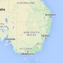


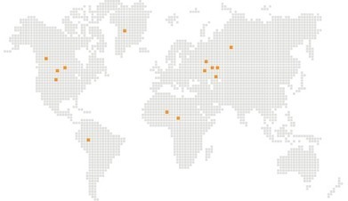
Use this interactive map to explore how population data are represented. Link to geography and mathematics outcomes.