 Your new post is loading...
Lion's Head is a mountain in Cape Town, South Africa, between Table Mountain and Signal Hill. Lion's Head peaks at 669 metres (2,195 ft) above sea level. The peak forms part of a dramatic backdrop to the city of Cape Town and is part of the Table Mountain National Park. Surrounding Lion's Head viewed from Signal Hill Lion's Head and Signal Hill from the Summit of Table Mountain, with Robben Island (top, middle) in Table Bay The suburbs of the city surround the peak and Signal Hill on almost all sides, but strict management by city authorities has kept development of housing off the higher ground. The area is significant to the Cape Malay community, who historically lived in the Bo-Kaap quarter close to Lion's Head. There are a number of historic graves and shrines (kramats) of Malay leaders on the lower slopes and on Signal Hill. History In the 17th century the peak was known as Leeuwen Kop (Lion's Head) by the Dutch, and Signal Hill was known as Leeuwen Staart (Lion's Tail), as the shape resembles a crouching lion or a sphinx. The English in the 17th century called the peak Sugar Loaf.[1][2] In 1897 gold was discovered on Lion's Head. A company was floated and a shaft sunk to a depth of more than 30 metres. However, the grade was too low, and the mine closed in the following year. Subsequently, the shaft was filled in and a small depression is all that remains today.[3] Activities Lion's Head is known for its views of both the city and the Atlantic Seaboard, and the hour-long walk to the top is particularly popular during a full moon.[1] Its slopes are also used as a launching point for paragliders. Lion's Head and Table Mountain peek above clouds The summit of Lion's Head Geology, flora and fauna The upper part of the peak consists of flat-lying Table Mountain sandstone and the lower slopes are formed by the Cape Granite and the Malmesbury formation, which are older Precambrian rocks. Lion's Head is covered in fynbos (indigenous Cape vegetation), with an unusually rich biodiversity that supports a variety of small animals. Three main vegetation types can be found in this relatively small area. All three of them are endemic to the city of Cape Town and can be found nowhere else. Most of Lion's Head is covered in endangered Granite Fynbos, which fades into Peninsula Shale Renosterveld (critically endangered) on the lower slopes towards Signal Hill in the north. Right on the summit of Lion's Head however, is a tiny patch of endangered Sandstone Fynbos, a different ecosystem that is also found nearby on the top of Table Mountain.[4][5][6] See also
Physical Energy is a bronze equestrian statue by the English artist George Frederic Watts. Watts was principally a painter, but also worked on sculptures from the 1870s. Physical Energy was first cast in 1902, two years before his death, and was intended to be Watts's memorial to "unknown worth". Watts said it was a symbol of "that restless physical impulse to seek the still unachieved in the domain of material things". The original plaster maquette is at the Watts Gallery, and there are four full-size bronze casts: one in London, one in Cape Town, one in Harare and one soon to be sited at Watts Gallery - Artists' Village in Compton, Surrey. Other smaller bronze casts were also made after Watts's death. Background The sculpture is based on Watts's earlier colossal bronze equestrian statue of Hugh Lupus, 1st Earl of Chester, commissioned in 1870 by his namesake Hugh Lupus Grosvenor, later 1st Duke of Westminster. The earlier work was completed in 1883-1884 and displayed at Eaton Hall, Cheshire. That statue was itself based on equestrian elements of the Elgin Marbles. Watts started work on Physical Energy in the early 1880s. The original 3.5 ton gesso grosso model (made of plaster mixed with glue size and hemp or tow) is at the Watts Gallery at Compton near Guildford. He was assisted by George Thompson and Louis Deuchars. The sculpture depicts a nude male figure on a rearing horse, set on a rectangular wedge-shaped base; the man's left hand holds the reins, while he shades his eyes from the sun with the right as he looks to the left. In the artist's own words, it is "a symbol of that restless physical impulse to seek the still unachieved in the domain of material things". Physical Energy was the culmination of Watts's ambition in the field of public sculpture, embodying the artist's belief that access to great art would bring immense benefits to the country at large, Watts conceived Physical Energy as an allegory of human vitality and humanity’s ceaseless struggle for betterment. Watts was reluctant to finalise and cast the work, despite encouragement from Millais to have it cast as early as 1886. Watts continued to modify the gesso model. It wasn’t until 1902 that the model was first cast in bronze. Casts The first full-size bronze cast of the sculpture was made at the Parlanti Foundry in Fulham in 1902. It was claimed to be the largest sculpture ever cast in bronze in Britain. Watts gave the statue to the British Government. Physical Energy was exhibited in the courtyard at Burlington House for the Royal Academy Summer Exhibition in 1904, the year of Watts's death. It was originally suggested that the statue be erected at the burial place of Cecil Rhodes in the Matopo Hills in Southern Rhodesia. Due to logistical impracticalities it was instead installed as part of the Rhodes Memorial on Devil's Peakabove Groote Schuur near Cape Town, South Africa. A second large cast was made in 1905, designed as a gift to the nation. It was cast at A.B. Burton's Thames Ditton Foundry in London. More refined, the second cast weighs 6 tons, and took eighteen months to create. It was delivered to London's Kensington Gardens, in September 1907, and unveiled at a site overlooking the north-west side of the Serpentine. A third full-size version of Physical Energy was cast in bronze in 1959, from the gesso model used for second cast. It differs slightly: for example, the rein appears on the right, like the first cast, rather than on the left, like the second cast. The British South Africa Company arranged for the statue to be cast at Leonard Grist's Corinthian Bronze Companyfoundry in London. It was originally located in front of the High Court building in Lusaka in Zambia. It was moved to a racecourse on the outskirts of Salisbury, in Southern Rhodesia (now Harare, in Zimbabwe). Since 1981, it has stood in the grounds of the National Archives in Harare. A fourth full-size bronze was commissioned by the Watts Gallery for the 200th anniversary of Watts's birth, and cast by Pangolin Editions in 2017 using a new mould made from the original gesso model. It was exhibited in the Annenberg Courtyard at the Royal Academy in 2017-18 as part of their bicentenary celebrations. The sculpture will be permanently installed at Watts Gallery – Artists’ Village, adjacent to the A3. Several smaller bronze versions were cast posthumously and sold commercially. One was exhibited at the Royal Academy in 1904. One example by Watts's assistant, Thomas Wren in 1914, sold by Bonhams for £40,000 in June 2014. Others in the collection of the Watts Gallery, at the Laing Art Gallery in Newcastle, the Harris Museum and Art Gallery in Preston, the Walker Art Gallery in Liverpool, and the Gibberd Gallery in Harlow. In 1960, at the unveiling of the Lusaka statue, Godfrey Huggins, 1st Viscount Malvern presented the Queen Mother with a silver replica of Physical Energy cast from a plaster model made by Sydney Harpley. Other uses The model of the statue is used as the logo for Watts Gallery – Artists’ Village. It also features as part of Rhodes University's logo, and the sculpture appears as a crest on its arms. An image of Physical Energy was used by the Labour Publishing Company Ltd in the 1920s. An image of the sculpture was also used as a trade mark for products such as Energen Rolls in the 1930s. The sculpture was one of the inspirations for Charles Villiers Stanford's Sixth Symphony, composed in memory of Watts. The Kensington Gardens cast is featured on the covers of some reissues of Coil’s album Horse Rotorvator, captured from a fisheye lens.
Segesta (Ancient Greek: Ἔγεστα, Egesta,[1] or Σέγεστα, Ségesta, or Αἴγεστα, Aígesta;[2] Sicilian: Siggesta) was one of the major cities of the Elymians, one of the three indigenous peoples of Sicily. The other major cities of the Elymians were Eryx and Entella. It is located in the northwestern part of Sicily in Italy, near the modern commune of Calatafimi-Segesta in the province of Trapani. The hellenization of Segesta happened very early and had a profound effect on its people.[3] History Origins The origin and foundation of Segesta are extremely obscure. The tradition current among the Greeks and adopted by Thucydides,[4]ascribed its foundation to a band of Trojan settlers, fugitives from the destruction of their city; and this tradition was readily welcomed by the Romans, who in consequence claimed a kindred origin with the Segestans. Thucydides seems to have considered the Elymians (Latin: Elymi), a barbarian tribe in the neighborhood of Eryx and Segesta, as descended from the Trojans in question; but another account represents the Elymi as a distinct people, already existing in this part of Sicily when the Trojans arrived there and founded the two cities. A different story seems also to have been current, according to which Segesta owed its origin to a band of Phocians, who had been among the followers of Philoctetes; and, as usual, later writers sought to reconcile the two accounts.[5][4] Another version of the Trojan story related in Virgil's Aeneid, which would seem to have been adopted by the inhabitants themselves, ascribed the foundation of the city jointly by the territorial king Egestus or Aegestus (the Acestes of Virgil), who was said to be the offspring of a Dardanian damsel named Segesta by the river god Crinisus, and by those of Aeneas' folk who wished to remain behind with Acestes to found the city of Acesta.[6] We are told also that the names of Simois and Scamander were given by the Trojan colonists to two small streams which flowed beneath the town,[7] and the latter name is mentioned by Diodorus Siculus as one still in use at a much later period.[8] The belief that the name of the city was originally Acesta or Egesta and changed to Segesta by the Romans to avoid its ill-omened meaning in Latin (egestās means "poverty" or "lack")[9] is disproved by coins which prove that considerably before the time of Thucydides it was called by the inhabitants themselves Segesta, though this form seems to have been softened by the Greeks of Magna Graecia into Egesta.[2] The city was occupied by a people distinct from the Sicanians, the native race of this part of Sicily, and on the other that it was not a Greek colony. Thucydides, in enumerating the allies of the Athenians at the time of the Peloponnesian War, distinctly calls the Segestans barbarians.[10] At the same time they appear to have been, from a very early period, in close connection with the Greek cities of Sicily, and entering into relations both of hostility and alliance with the Hellenic states, wholly different from the other barbarians in the island. The early influence of Greek civilisation is shown also by their coins, which are inscribed with Greek characters, and bear the unquestionable impress of Greek art. In historical accounts The first historical notice of the Segestans transmitted to us represents them as already engaged (as early as 580 BC) in hostilities with Selinus (modern Selinunte), which would appear to prove that both cities had already extended their territories so far as to come into contact with each other. By the timely assistance of a body of Cnidian and Rhodianemigrants under Pentathlus, the Segestans at this time obtained the advantage over their adversaries.[11] A more obscure statement of Diodorus relates that again in 454 BC, the Segestans were engaged in hostilities with the Lilybaeans for the possession of the territory on the river Mazarus.[12] The name of the Lilybaeans is here certainly erroneous, as no town of that name existed till long afterwards; but we know not what people is really meant, though the presumption is that it is the Selinuntines, with whom the Segestans seem to have been engaged in almost perpetual disputes. It was doubtless with a view to strengthen themselves against these neighbors that the Segestans took advantage of the first Athenian expedition to Sicily under Laches (426 BC), and concluded a treaty of alliance with Athens.[13] This, however, seems to have led to no result, and shortly after, hostilities having again broken out, the Selinuntines called in the aid of the Syracusans, with whose assistance they obtained great advantages, and were able to press Segesta closely both by land and sea. In this extremity the Segestans, having in vain applied for assistance to Agrigentum, and even to Carthage, again had recourse to the Athenians, who were, without much difficulty, persuaded to espouse their cause, and send a fleet to Sicily in 416 BC.[13][14] It is said that this result was in part attained by fraud, the Segestans having deceived the Athenian envoys by a fallacious display of wealth, and led them to conceive a greatly exaggerated notion of their resources. They, however, actually furnished 60 talents in ready money, and 30 more after the arrival of the Athenian armament.[15][16] But though the relief of Segesta was thus the original object of the great Athenian expedition to Sicily (415–413 BC), that city bears little part in the subsequent operations of the war. Nicias, indeed, on arriving in the island, proposed to proceed at once to Selinus, and compel that people to submission by the display of their formidable armament. But this advice was overruled: the Athenians turned their arms against Syracuse, and the contest between Segesta and Selinus was almost forgotten in the more important struggle between those two great powers. In the summer of 415 BC an Athenian fleet, proceeding along the coast, took the small town of Hyccara, on the coast, near Segesta, and made it over to the Segestans.[17][18] The latter people are again mentioned on more than one occasion as sending auxiliary troops to assist their Athenian allies;[19][20] but no other notice occurs of them. The final defeat of the Athenians left the Segestans again exposed to the attacks of their neighbors, the Selinuntines. Feeling themselves unable to cope with them, they again had recourse to the Carthaginians, who determined to espouse their cause, and sent them, in the first instance, an auxiliary force of 5000 Africans and 800 Campanianmercenaries, which sufficed to ensure them a victory over their rivals in 410 BC.[21] This was followed the next year by a vast armament under Hannibal Mago, who landed at Lilybaeum, and, proceeding direct to Selinus, took and destroyed that city[22] as well as Himera. The Carthaginian power now became firmly established in the western portion of Sicily. Segesta, surrounded on all sides by this formidable neighbor, naturally fell gradually into the position of a dependent ally of Carthage. It was one of the few cities that remained faithful to this alliance even in 397 BC, when the great expedition of Dionysius I of Syracuse to the West of Sicily and the siege of Motya seemed altogether to shake the power of Carthage. Dionysius in consequence laid siege to Segesta, and pressed it with the utmost vigor, especially after the fall of Motya. The city, however, was able to defy his efforts, until the landing of Himilco with a formidable Carthaginian force changed the aspect of affairs, and compelled Dionysius to raise the siege.[23] From this time there are few mentions of Segesta till the time of Agathocles of Syracuse, under whom it suffered a great calamity. The despot landed in the West of Sicily on his return from Africa (307 BC), and was received into the city as a friend and ally. He suddenly turned upon the inhabitants on a pretence of disaffection, and put the whole of the citizens (said to amount to 10,000 in number) to the sword, plundered their wealth, and sold the women and children into slavery. He then changed the name of the city to Dicaeopolis, and assigned it as a residence to the fugitives and deserters that had gathered around him.[24] It is probable that Segesta never altogether recovered this blow; but it soon resumed its original name, and again appears in history as an independent city. Thus it is mentioned in 276 BC, as one of the cities which joined Pyrrhus of Epirus during his expedition into the West of Sicily.[25] It, however, soon after fell again under the power of the Carthaginians; and it was probably on this occasion that the city was taken and plundered by them, as alluded to by Cicero;[26] a circumstance of which there are no other account. It continued subject to, or at least dependent on that people, till the First Punic War. In the first year of that war (264 BC) it was attacked by the consul Appius Claudius Caudex, but without success;[27] but shortly after the inhabitants put the Carthaginian garrison to the sword, and declared for the alliance of Rome.[28][29] They were in consequence besieged by a Carthaginian force, and were at one time reduced to great straits, but were relieved by the arrival of Gaius Duilius, after his naval victory in 260 BC.[30]Segesta seems to have been one of the first of the Sicilian cities to set the example of defection from Carthage; on which account, as well as of their pretended Trojan descent, the inhabitants were treated with great distinction by the Romans. They were exempted from all public burdens, and even as late as the time of Cicero continued to be "sine foedere immunes ac liberi" – a free and immune city.[31] After the destruction of Carthage, Scipio Africanus restored to the Segestans a statue of Diana which had been carried off by the Carthaginians, probably when they obtained possession of the city after the departure of Pyrrhus.[32] During the Second Servile War also, in 102 BC, the territory of Segesta is again mentioned as one of those where the insurrection broke out with the greatest fury.[33] But with the exception of these incidental notices we hear little of it under the Roman government. It seems to have been still a considerable town in the time of Cicero, and had a port or emporium of its own on the bay about 10 km distant.[34][35] This emporium seems to have grown up in the days of Strabo to be a more important place than Segesta itself: but the continued existence of the ancient city is attested both by Pliny and Ptolemy; and we learn from the former that the inhabitants, though they no longer retained their position of nominal independence, enjoyed the privileges of the Latin citizenship.[36][37][38] It seems, however, to have been a decaying place, and no trace of it is subsequently found in history. The site is said to have been finally abandoned, in consequence of the ravages of the Saracens, in 900 AD,[39] and is now wholly desolate. The modern town of Castellammare del Golfo, about 10 km distant, occupies nearly, if not precisely, the same site as the ancient emporium or port of Segesta. Situation The Greek theater The ruins of the city are located on the top of Monte Bàrbaro at 305 m above sea level. The city was protected by steep slopes on several sides and by walls on the more gentle slope towards the temple. The hilltop offers a view over the valley towards the Gulf of Castellamare. The city controlled several major roads between the coast to the north and the hinterland. Very little is known about the city plan. Aerial photography indicates a regular city plan, built in part on terraces to overcome the natural sloping terrain. The current remains might be from the reconstruction after the destruction of the city by Agathocles. Current archaeological work indicates that the site was reoccupied by a Muslim community in the Norman period. Excavations have unearthed a Muslim necropolis and a mosque from the 12th century next to a Norman castle. Evidence suggests that the mosque was destroyed after the arrival of a new Christian overlord at the beginning of the 13th century. The city appears to have been finally abandoned by the second half of the 13th century. The temple Segesta Temple in Thomas Cole's painting from 1843 On a hill just outside the site of the ancient city of Segesta lies an unusually well-preserved Doric temple. Some think it to have been built in the 420s BC by an Athenian architect, despite the city not having any Greek population.[40] The prevailing view is that it was built by the indigenous Elymians.[41][42] The temple has six by fourteen columns on a base measuring 21 by 56 metres, on a platform three steps high. Several elements suggest that the temple was never finished. The columns have not been fluted as they normally would have been in a Doric temple, and there are still bosses present in the blocks of the base (used for lifting the blocks into place but then normally removed). The temple also lacks a cella, any ornamentation, altar or deity dedication, and was never roofed over.[43] The temple was never completed due to the war between Segesta and Selinunte.[44] It managed to escape destruction by the Carthaginians in the late 5th century BC.
Colonialism is the control of another territory, natural resources and people by a foreign group.[1][2][3][4][5] Colonizers control the political and tribal power of the colonised territory.[6][7] While frequently an imperialist project, colonialism can also take the form of settler colonialism, whereby settlers from one or multiple colonizing metropoles occupy a territory with the intention of partially or completely supplanting the existing population.[8][9]: 2 [10] Colonialism developed as a concept describing European colonial empires of the modern era, which spread globally from the 15th century to the mid-20th century, spanning 35% of Earth's land by 1800 and peaking at 84% by the beginning of World War I.[11] European colonialism employed mercantilismand chartered companies, and established coloniality, which keeps the colonized socio-economically othered and subaltern through modern biopolitics of sexuality, gender, race, disability and class, among others, resulting in intersectional violence and discrimination.[12][13] Colonialism has been justified with beliefs of having a civilizing mission to cultivate land and life, based on beliefs of entitlement and superiority, historically often rooted in the belief of a Christian mission. Part of a series on Colonialism Colonization Concepts By region Empires Settler states Decolonization Concepts By region v t e Because of this broad impact different instances of colonialism have been identified from around the world and in history, starting with when colonization was developed by developing colonies and metropoles, the base colonial separation and characteristic.[8] Decolonization, which started in the 18th century, gradually led to the independence of colonies in waves, with a particular large wave of decolonizations happening in the aftermath of World War II between 1945 and 1975.[14][15] Colonialism has a persistent impact on a wide range of modern outcomes, as scholars have shown that variations in colonial institutions can account for variations in economic development,[16][17][18] regime types,[19][20] and state capacity.[21][22] Some academics have used the term neocolonialism to describe the continuation or imposition of elements of colonial rule through indirect means in the contemporary period.[23][24] Etymology See also: Colony § Etymology, and Colonization § Etymology Colonialism is etymologically rooted in the Latin word "Colonus", which was used to describe tenant farmers in the Roman Empire.[4] The coloni sharecroppers started as tenants of landlords, but as the system evolved they became permanently indebted to the landowner and trapped in servitude. Definitions The East Offering its Riches to Britannia, painted by Spiridione Romafor the boardroom of the British East India Company The earliest uses of colonialism referred to plantations that men emigrated to and settled.[25] The term expanded its meaning in the early 20th century to primarily refer to European imperial expansion and the imperial subjection of Asian and African peoples.[25] Collins English Dictionary defines colonialism as "the practice by which a powerful country directly controls less powerful countries and uses their resources to increase its own power and wealth".[3] Webster's Encyclopedic Dictionary defines colonialism as "the system or policy of a nation seeking to extend or retain its authority over other people or territories".[2] The Merriam-Webster Dictionary offers four definitions, including "something characteristic of a colony" and "control by one power over a dependent area or people".[26] The Stanford Encyclopedia of Philosophy uses the term "to describe the process of European settlement and political control over the rest of the world, including the Americas, Australia, and parts of Africa and Asia". It discusses the distinction between colonialism, imperialism and conquest and states that "[t]he difficulty of defining colonialism stems from the fact that the term is often used as a synonym for imperialism. Both colonialism and imperialism were forms of conquest that were expected to benefit Europe economically and strategically," and continues "given the difficulty of consistently distinguishing between the two terms, this entry will use colonialism broadly to refer to the project of European political domination from the sixteenth to the twentieth centuries that ended with the national liberation movements of the 1960s".[4] In his preface to Jürgen Osterhammel's Colonialism: A Theoretical Overview, Roger Tignor says "For Osterhammel, the essence of colonialism is the existence of colonies, which are by definition governed differently from other territories such as protectorates or informal spheres of influence."[1] In the book, Osterhammel asks, "How can 'colonialism' be defined independently from 'colony?'"[27] He settles on a three-sentence definition: Colonialism is a relationship between an indigenous (or forcibly imported) majority and a minority of foreign invaders. The fundamental decisions affecting the lives of the colonised people are made and implemented by the colonial rulers in pursuit of interests that are often defined in a distant metropolis. Rejecting cultural compromises with the colonised population, the colonisers are convinced of their own superiority and their ordained mandate to rule.[28] According to Julian Go, "Colonialism refers to the direct political control of a society and its people by a foreign ruling state... The ruling state monopolizes political power and keeps the subordinated society and its people in a legally inferior position."[6] He also writes, "colonialism depends first and foremost upon the declaration of sovereignty and/or territorial seizure by a core state over another territory and its inhabitants who are classified as inferior subjects rather than equal citizens."[7] Australian historian Lorenzo Veracini defines colonialism as the establishment and maintenance of an unequal relationship between a colonial metropole and a colonized territory through violence.[9]: 1–4 He argues that "displacement and violence are the two necessary ingredients that sustain colonialism as an unequal relationship.": 1 The imbalance of power that results from a colonial relationship allows a colonial metropole to exploit unequal trading terms between it and its colonies. According to David Strang, decolonization is achieved through the attainment of sovereign statehood with de jurerecognition by the international community or through full incorporation into an existing sovereign state.[29] Types of colonialism Dutch family in Java, 1927 The Times once quipped that there were three types of colonial empire: "The English, which consists in making colonies with colonists; the German, which collects colonists without colonies; the French, which sets up colonies without colonists."[30] Modern studies of colonialism have often distinguished between various overlapping categories of colonialism, broadly classified into four types: settler colonialism, exploitation colonialism, surrogate colonialism, and internal colonialism. Some historians have identified other forms of colonialism, including national and trade forms.[31] Settler colonialism involves large-scale immigration by settlers to colonies, often motivated by religious, political, or economic reasons. This form of colonialism aims largely to supplant prior existing populations with a settler one, and involves large number of settlers emigrating to colonies for the purpose of establishing settlements.[31] Argentina, Australia, Brazil, Canada, Chile, China, Israel, Indian-controlled Kashmir, New Zealand, Northern Ireland, Russia, South Africa, the United States, and Uruguay, are examples of nations created or expanded in their contemporary form by settler colonialism.[8][32][33][34][35][36][9]: 83–84 French-controlled Algeria, Rhodesia (now Zimbabwe), Italian-controlled Libya, the Kenya Colony, Japanese-controlledKorea and Manchuria, and most infamously Nazi-occupied Eastern Europe[37]: 462–463 are examples of past or failed attempts to establish settler colonies.[9]: 83–84 Exploitation colonialism involves fewer colonists and focuses on the exploitation of natural resources or labour to the benefit of the metropole. This form consists of trading posts as well as larger colonies where colonists would constitute much of the political and economic administration. The European colonization of Africa and Asia was largely conducted under the auspices of exploitation colonialism.[38] Surrogate colonialism involves a settlement project supported by a colonial power, in which most of the settlers do not come from the same ethnic group as the ruling power, as it has been (controversially) argued was the case of Mandatory Palestine and the Colony of Liberia.[39][40] Internal colonialism is a notion of uneven structural power between areas of a state. The source of exploitation comes from within the state. This is demonstrated in the way control and exploitation may pass from people from the colonizing country to an immigrant population within a newly independent country.[41][42] Harbour Street, Kingston, Jamaica, c. 1820 National colonialism is a process involving elements of both settler and internal colonialism, in which nation-building and colonization are symbiotically connected, with the colonial regime seeking to remake the colonized peoples into their own cultural and political image. The goal is to integrate them into the state, but only as reflections of the state's preferred culture. The Taiwan under the KMT's military dictatorship is the archetypal example of a national-colonialist society.[43] Trade colonialism involves the undertaking of colonialist ventures in support of trade opportunities for merchants. This form of colonialism was most prominent in 19th-century Asia, where previously isolationist states were forced to open their ports to Western powers. Examples of this include the Opium Wars and the opening of Japan.[44][45] Socio-cultural evolution Further information: Coloniality of power When colonists settled in pre-populated areas, the societies and cultures of the people in those areas permanently changed. Colonial practices directly and indirectly forced the colonized peoples to abandon their traditional cultures. For example, European colonizers in the United States implemented the residential schools program to force native children to assimilate into the hegemonic culture. Cultural colonialism gave rise to culturally and ethnically mixed populations such as the mestizos of the Americas, as well as racially divided populations such as those found in French Algeria or in Southern Rhodesia. In fact, everywhere where colonial powers established a consistent and continued presence, hybrid communities existed. Notable examples in Asia include the Anglo-Burmese, Anglo-Indian, Burgher, Eurasian Singaporean, Filipino mestizo, Kristang, and Macanese peoples. In the Dutch East Indies (later Indonesia) the vast majority of "Dutch" settlers were in fact Eurasians known as Indo-Europeans, formally belonging to the European legal class in the colony.[46][47] American Progress (1872) by John Gast is an allegorical representation of the idea of manifest destiny. Columbia, a personification of the United States, leads settler civilization westward, bringing light, stringing telegraph wire, holding a book,[48] and highlighting different stages of economic activity and evolving forms of transportation,[49] while on the left, displacing Native Americans in the United States from their homeland History Main articles: History of colonialism, List of colonies, and Chronology of Western colonialism Antiquity Activity that could be called colonialism has a long history, starting at least as early as the ancient Egyptians. Phoenicians, Greeks, and Romans founded colonies in antiquity. Phoeniciahad an enterprising maritime trading-culture that spread across the Mediterranean from 1550 BC to 300 BC; later the Persian Empire and various Greek city-states continued on this line of setting up colonies. The Romans would soon follow, setting up coloniae throughout the Mediterranean, in North Africa, and in Western Asia.[citation needed] Medieval Beginning in the 7th century, Arabs colonized a substantial portion of the Middle East, North Africa, and parts of Asia and Europe.[citation needed] From the 9th century Vikings(Norsemen) such as Leif Erikson established colonies in Britain, Ireland, Iceland, Greenland, North America, present-day Russia and Ukraine, France (Normandy) and Sicily.[50] In the 9th century a new wave of Mediterraneancolonisation began, with competitors such as the Venetians, Genovese and Amalfians infiltrating the wealthy previously Byzantine or Eastern Roman islands and lands. European Crusaders set up colonial regimes in Outremer(in the Levant, 1097–1291) and in the Baltic littoral (12th century onwards). Venice began to dominate Dalmatia and reached its greatest nominal colonial extent at the conclusion of the Fourth Crusade in 1204, with the declaration of the acquisition of three octaves of the Byzantine Empire.[51] Modern Iberian Union of Spain and Portugal between 1580 and 1640 Modern colonialism is generally considered to have begun with the Spanish conquest of the Canary Islands when "the relationships involved in domination became recognisably colonial."[9]: 10 Following the fall of Constantinople to the Ottoman Empire in 1453, the sea routes discovered by Portuguese Prince Henry the Navigator (1394–1460) became central to trade, and helped fuel the Age of Discovery.[52] The Crown of Castileencountered the Americas in 1492 through sea travel and built trading posts or conquered large extents of land. The Treaty of Tordesillas divided the areas of these "new" lands between the Spanish Empire and the Portuguese Empire in 1494.[52] The 17th century saw the birth of the Dutch Empire and French colonial empire, as well as the English overseas possessions, which later became the British Empire. It also saw the establishment of Danish overseas colonies and Swedish overseas colonies.[53] A first wave of separatism started with the American Revolutionary War (1775–1783), initiating the Rise of the "Second" British Empire (1783–1815).[54] The Spanish Empire largely collapsed in the Americas with the Spanish American wars of independence (1808–1833). Empire-builders established several new colonies after this time, including in the German colonial empire and Belgian colonial empire.[55] Starting with the end of the French RevolutionEuropean authors such as Johann Gottfried Herder, August von Kotzebue, and Heinrich von Kleist prolifically published so as to conjure up sympathy for the oppressed native peoples and the slaves of the new world, thereby starting the idealization of native humans.[56] The Habsburg monarchy, the Russian Empire, and the Ottoman Empire existed at the same time but did not expand over oceans. Rather, these empires expanded through the conquest of neighbouring territories. There was, though, some Russian colonization of North America across the Bering Strait. The Empire of Brazil fought for hegemony in South America. The United States gained overseas territories after the 1898 Spanish–American War, hence, the coining of the term "American imperialism".[57] The Japanese colonial empire began in the mid-19th century with the settler colonization of Hokkaido and the destruction of the island's indigenous Ainu people before moving onto the Ryukyu Islands (the indigenous Ryukyuan people survived colonization more intact). After the Meiji Restoration, Japan more formally developed its colonial policies with the help of European advisors. The stated purpose from the beginning was to compensate for the lack of resources on the main islands of Japan by securing control over natural resources in Asia for its own economic development and industrialization, not unlike its European counterparts. Japan defeated China in the First Sino-Japanese War to control Korea and the island of Formosa, now Taiwan, and later fought off the Russian Empire to control Port Arthur and South Sakhalin.[9]: 147–152 In the late 19th century, many European powers became involved in the Scramble for Africa.[55] 20th century The Harmsworth atlas and Gazetter 1908 European colonization map The world's colonial population at the outbreak of the First World War – a high point for colonialism – totalled about 560 million people, of whom 70% lived in British possessions, 10% in French possessions, 9% in Dutch possessions, 4% in Japanese possessions, 2% in German possessions, 2% in American possessions, 3% in Portuguese possessions, 1% in Belgian possessions and 0.5% in Italian possessions. The domestic domains of the colonial powers had a total population of about 370 million people.[58] Outside Europe, few areas had remained without coming under formal colonial tutorship – and even Siam, China, Japan, Nepal, Afghanistan, Persia, and Abyssinia had felt varying degrees of Western colonial-style influence – concessions, unequal treaties, extraterritoriality and the like. Asking whether colonies paid, economic historian Grover Clark (1891–1938) argues an emphatic "No!" He reports that in every case the support cost, especially the military system necessary to support and defend colonies, outran the total trade they produced. Apart from the British Empire, they did not provide favoured destinations for the immigration of surplus metropole populations.[59] The question of whether colonies paid is a complicated one when recognizing the multiplicity of interests involved. In some cases colonial powers paid a lot in military costs while private investors pocketed the benefits. In other cases the colonial powers managed to move the burden of administrative costs to the colonies themselves by imposing taxes.[60] Map of colonial and land-based empires throughout the world in 1914 Imperial powers in 1945 World War I The First World War brought the European colonial empires into conflict with each other with the fight sustained by their colonial territories.[61]: 130 "The demands of war mobilisation intensified colonial exploitation everywhere, and there were several anticolonial uprisings against conscription." Germany capitulated in large part due to the Allied sea blockade cutting off access to its overseas colonies, a disadvantage which German U-boats could not inflict on the Allies. The victorious Allies divided up the German colonial empire and much of the Ottoman Empire between themselves as League of Nations mandates, grouping these territories into three classes according to how quickly it was deemed that they could prepare for independence. The empires of Russia and Austria collapsed in 1917–1918,[62] and the Soviet empire emerged.[63] Interwar Years Anti-colonial sentiment surged during the interwar years.[61]: 130-136 The Easter Rising and Irish War of Independenceled to the UK conceding independence to Ireland. Turkey became an independent country in the ruins of the Ottoman Empire and fought off interventions from Britain, France, and Italy. The first Pan-African Congress would take place in Paris in 1919.[64] The Soviet Union positioned itself as an "an explicitly anti-imperialist power"[61]: 130 and would play an important role in the success of anticolonial resistance movements in Asia and Africa, although its own policies in Central Asia resembled the colonial policies of the Russian empire that preceded it.[65] At the same time, Japan expanded its colonies in Asia and the Pacific. World War II Many interpret World War II as an attempt by Nazi Germany and its allies to colonize the whole European continent, especially in the east. Historian Lorenzo Veracini writes, "The global history of colonialism can be seen as bookended by two fateful moments: European armies crossed the strait of Gibraltar in the fifteenth century to establish unequal relations of domination in Africa, and a colonial army crossed it in the opposite direction in 1936, to conquer the metropole and pursue a civil war that subjected the metropolitan populations with a violence that had been until then reserved for restive colonized subjects."[61]: 5 Economic historian Adam Tooze posits that Operation Barbarossa is "far better understood as the last great land-grab in the long and bloody history of European colonialism."[37]: 462 "From the moment that Germany invaded Poland in September 1939, the genocidal impulses of Nazi ideology towards both the Jews and the Slavs had taken on concrete form in an extraordinary programme of population displacement and colonial settlement.": 463 Generalplan Ost, the Nazi government's grand plan of settler colonialism, called for the mass murder and deportation of at least 30 million Slavs from Poland and the western Soviet Union in preparation for the importation of millions of German settlers.: 462-467 The plan was lauded as a 'solution' to secure Germany's food supply for the duration of the war, unlike the previous one. Hitler repeatedly drew parallels between the colonization plan and Manifest Destiny in the United States. Aimé Césaire argues in Discourse on Colonialism, "[Europeans] tolerated that Nazism before it was inflicted on them, they absolved it, shut their eyes to it, legitimized it, because, until then, it had been applied only to non-European peoples."[66] Post-WWII Decolonization In the aftermath of World War II, decolonisation progressed rapidly. The tumultuous upheaval of the war significantly weakened the major colonial powers, and they quickly lost control of colonies such as Singapore, India, and Libya.[67]In addition, the United Nations shows support for decolonisation in its 1945 charter. In 1960, the UN issued the Declaration on the Granting of Independence to Colonial Countries and Peoples, which affirmed its stance (though notably, colonial empires such as France, Spain, the United Kingdom, and the United States abstained).[68] The word "neocolonialism" originated from Jean-Paul Sartre in 1956,[69] to refer to a variety of contexts since the decolonisation that took place after World War II. Generally it does not refer to a type of direct colonisation – rather to colonialism or colonial-style exploitation by other means. Specifically, neocolonialism may refer to the theory that former or existing economic relationships, such as the General Agreement on Tariffs and Trade and the Central American Free Trade Agreement, or the operations of companies (such as Royal Dutch Shell in Nigeria and Brunei) fostered by former colonial powers were or are used to maintain control of former colonies and dependencies after the colonial independence movements of the post–World War II period.[70] The term became popular in ex-colonies in the late 20th century.[71] Contemporary While colonies of contiguous empires[72] have been historically excluded, they can be seen as colonies.[73]Contemporary expansion of colonies is seen by some in case of Russian imperialism[74] and Chinese imperialism.[75]There is also ongoing debate in academia about Zionism as settler colonialism. Impact Main article: Analysis of Western European colonialism and colonization § Colonial actions and their impacts A 1904 cartoon by Bob Satterfieldabout the brutality committed by Western nations: the personifications of England, the United States, and Germany carrying spears topped by the severed heads of Tibet, the Philippines, and Southwest Africa respectively. The caption describes this as "The advance guard of civilization". Duration: 1 minute and 49 seconds.1:49 The Dutch Public Health Service provides medical care for the natives of the Dutch East Indies, May 1946. The impacts of colonisation are immense and pervasive.[76] Various effects, both immediate and protracted, include the spread of virulent diseases, unequal social relations, detribalization, exploitation, enslavement, medical advances, the creation of new institutions, abolitionism,[77] improved infrastructure,[78] and technological progress.[79] Colonial practices also spur the spread of conquerors' languages, literature and cultural institutions, while endangering or obliterating those of Indigenous peoples. The cultures of the colonised peoples can also have a powerful influence on the imperial country.[80] With respect to international borders, Britain and France traced close to 40% of the entire length of the world's international boundaries.[81] Economy, trade and commerce Economic expansion, sometimes described as the colonial surplus, has accompanied imperial expansion since ancient times.[citation needed] Greek trade networks spread throughout the Mediterranean region while Roman trade expanded with the primary goal of directing tribute from the colonised areas towards the Roman metropole. According to Strabo, by the time of emperor Augustus, up to 120 Roman ships would set sail every year from Myos Hormos in Roman Egypt to India.[82] With the development of trade routes under the Ottoman Empire, Gujari Hindus, Syrian Muslims, Jews, Armenians, Christians from south and central Europe operated trading routes that supplied Persian and Arab horses to the armies of all three empires, Mocha coffee to Delhi and Belgrade, Persian silk to India and Istanbul.[83] Portuguese trade routes (blue) and the rival Manila-Acapulco galleons trade routes (white) established in 1568 Aztec civilisation developed into an extensive empire that, much like the Roman Empire, had the goal of exacting tribute from the conquered colonial areas. For the Aztecs, a significant tribute was the acquisition of sacrificial victims for their religious rituals.[84] On the other hand, European colonial empires sometimes attempted to channel, restrict and impede trade involving their colonies, funneling activity through the metropole and taxing accordingly. Despite the general trend of economic expansion, the economic performance of former European colonies varies significantly. In "Institutions as a Fundamental Cause of Long-run Growth", economists Daron Acemoglu, Simon Johnson and James A. Robinson compare the economic influences of the European colonists on different colonies and study what could explain the huge discrepancies in previous European colonies, for example, between West African colonies like Sierra Leone and Hong Kong and Singapore.[85] According to the paper, economic institutions are the determinant of the colonial success because they determine their financial performance and order for the distribution of resources. At the same time, these institutions are also consequences of political institutions – especially how de facto and de jure political power is allocated. To explain the different colonial cases, we thus need to look first into the political institutions that shaped the economic institutions.[85] Dutch East India Company was the first-ever multinational corporation, financed by shares that established the first modern stock exchange. For example, one interesting observation is "the Reversal of Fortune" – the less developed civilisations in 1500, like North America, Australia, and New Zealand, are now much richer than those countries who used to be in the prosperous civilisations in 1500 before the colonists came, like the Mughals in India and the Incas in the Americas. One explanation offered by the paper focuses on the political institutions of the various colonies: it was less likely for European colonists to introduce economic institutions where they could benefit quickly from the extraction of resources in the area. Therefore, given a more developed civilisation and denser population, European colonists would rather keep the existing economic systems than introduce an entirely new system; while in places with little to extract, European colonists would rather establish new economic institutions to protect their interests. Political institutions thus gave rise to different types of economic systems, which determined the colonial economic performance.[85] European colonisation and development also changed gendered systems of power already in place around the world. In many pre-colonialist areas, women maintained power, prestige, or authority through reproductive or agricultural control. For example, in certain parts of Sub-Saharan Africa women maintained farmland in which they had usage rights. While men would make political and communal decisions for a community, the women would control the village's food supply or their individual family's land. This allowed women to achieve power and autonomy, even in patrilineal and patriarchal societies.[86] Through the rise of European colonialism came a large push for development and industrialisation of most economic systems. When working to improve productivity, Europeans focused mostly on male workers. Foreign aid arrived in the form of loans, land, credit, and tools to speed up development, but were only allocated to men. In a more European fashion, women were expected to serve on a more domestic level. The result was a technologic, economic, and class-based gender gap that widened over time.[87] Within a colony, the presence of extractive colonial institutions in a given area has been found have effects on the modern day economic development, institutions and infrastructure of these areas.[88][89] Slavery and indentured servitude Further information: Atlantic slave trade, Indentured servant, Coolie, and Blackbirding European nations entered their imperial projects with the goal of enriching the European metropoles. Exploitation of non-Europeans and of other Europeans to support imperial goals was acceptable to the colonisers. Two outgrowths of this imperial agenda were the extension of slavery and indentured servitude. In the 17th century, nearly two-thirds of English settlers came to North America as indentured servants.[90] European slave traders brought large numbers of African slaves to the Americas by sail. Spain and Portugal had brought African slaves to work in African colonies such as Cape Verde and São Tomé and Príncipe, and then in Latin America, by the 16th century. The British, French and Dutch joined in the slave trade in subsequent centuries. The European colonial system took approximately 11 million Africans to the Caribbean and to North and South America as slaves.[91] Slave traders in Gorée, Senegal, 18th century European empire Colonial destination Number of slaves imported between 1450 and 1870[91] Portuguese Empire Brazil 3,646,800 British Empire British Caribbean 1,665,000 French Empire French Caribbean 1,600,200 Spanish Empire Latin America 1,552,100 Dutch Empire Dutch Caribbean 500,000 British Empire British North America 399,000 Abolitionists in Europe and Americas protested the inhumane treatment of African slaves, which led to the elimination of the slave trade (and later, of most forms of slavery) by the late 19th century. One (disputed) school of thought points to the role of abolitionism in the American Revolution: while the British colonial metropole started to move towards outlawing slavery, slave-owning elites in the Thirteen Colonies saw this as one of the reasons to fight for their post-colonial independence and for the right to develop and continue a largely slave-based economy.[92] British colonising activity in New Zealand from the early 19th century played a part in ending slave-taking and slave-keeping among the indigenous Māori.[93][94] On the other hand, British colonial administration in Southern Africa, when it officially abolished slavery in the 1830s, caused rifts in society which arguably perpetuated slavery in the Boer Republics and fed into the philosophy of apartheid.[95] Planting the sugar cane, Antigua, 1823 The labour shortages that resulted from abolition inspired European colonisers in Queensland, British Guaiana and Fiji (for example) to develop new sources of labour, re-adopting a system of indentured servitude. Indentured servantsconsented to a contract with the European colonisers. Under their contract, the servant would work for an employer for a term of at least a year, while the employer agreed to pay for the servant's voyage to the colony, possibly pay for the return to the country of origin, and pay the employee a wage as well. The employees became "indentured" to the employer because they owed a debt back to the employer for their travel expense to the colony, which they were expected to pay through their wages. In practice, indentured servants were exploited through terrible working conditions and burdensome debts imposed by the employers, with whom the servants had no means of negotiating the debt once they arrived in the colony. India and China were the largest source of indentured servants during the colonial era. Indentured servants from India travelled to British colonies in Asia, Africa and the Caribbean, and also to French and Portuguese colonies, while Chinese servants travelled to British and Dutch colonies. Between 1830 and 1930, around 30 million indentured servants migrated from India, and 24 million returned to India. China sent more indentured servants to European colonies, and around the same proportion returned to China.[96] Following the Scramble for Africa, an early but secondary focus for most colonial regimes was the suppression of slavery and the slave trade. By the end of the colonial period they were mostly successful in this aim, though slavery persists in Africa and in the world at large with much the same practices of de facto servility despite legislative prohibition.[77] Military innovation The First Anglo-Ashanti War, 1823–1831 Conquering forces have throughout history applied innovation in order to gain an advantage over the armies of the people they aim to conquer. Greeks developed the phalanx system, which enabled their military units to present themselves to their enemies as a wall, with foot soldiers using shields to cover one another during their advance on the battlefield. Under Philip II of Macedon, they were able to organise thousands of soldiers into a formidable battle force, bringing together carefully trained infantry and cavalry regiments.[97] Alexander the Great exploited this military foundation further during his conquests. The Spanish Empire held a major advantage over Mesoamerican warriors through the use of weapons made of stronger metal, predominantly iron, which was able to shatter the blades of axes used by the Aztec civilisation and others. The use of gunpowder weapons cemented the European military advantage over the peoples they sought to subjugate in the Americas and elsewhere. End of empire This section does not cite any sources. Please help improve this section by adding citations to reliable sources. Unsourced material may be challenged and removed. (April 2021) (Learn how and when to remove this message) Gandhi with Lord Pethwick-Lawrence, British Secretary of State for India, after a meeting on 18 April 1946 The populations of some colonial territories, such as Canada, enjoyed relative peace and prosperity as part of a European power, at least among the majority. Minority populations such as First Nations peoples and French-Canadians experienced marginalisation and resented colonial practices. Francophone residents of Quebec, for example, were vocal in opposing conscription into the armed services to fight on behalf of Britain during World War I, resulting in the Conscription crisis of 1917. Other European colonies had much more pronounced conflict between European settlers and the local population. Rebellions broke out in the later decades of the imperial era, such as India's Sepoy Rebellion of 1857. The territorial boundaries imposed by European colonisers, notably in central Africa and South Asia, defied the existing boundaries of native populations that had previously interacted little with one another. European colonisers disregarded native political and cultural animosities, imposing peace upon people under their military control. Native populations were often relocated at the will of the colonial administrators. The Partition of British India in August 1947 led to the Independence of India and the creation of Pakistan. These events also caused much bloodshed at the time of the migration of immigrants from the two countries. Muslims from India and Hindus and Sikhs from Pakistan migrated to the respective countries they sought independence for. Post-independence population movement The annual Notting Hill Carnival in London is a celebration led by the Trinidadian and Tobagonian Britishcommunity. In a reversal of the migration patterns experienced during the modern colonial era, post-independence era migration followed a route back towards the imperial country. In some cases, this was a movement of settlers of European origin returning to the land of their birth, or to an ancestral birthplace. 900,000 French colonists (known as the Pied-Noirs) resettled in France following Algeria's independence in 1962. A significant number of these migrants were also of Algerian descent. 800,000 people of Portuguese origin migrated to Portugal after the independence of former colonies in Africa between 1974 and 1979; 300,000 settlers of Dutch origin migrated to the Netherlands from the Dutch West Indies after Dutch military control of the colony ended.[98] After WWII 300,000 Dutchmen from the Dutch East Indies, of which the majority were people of Eurasian descent called Indo Europeans, repatriated to the Netherlands. A significant number later migrated to the US, Canada, Australia and New Zealand.[99][100] Global travel and migration in general developed at an increasingly brisk pace throughout the era of European colonial expansion. Citizens of the former colonies of European countries may have a privileged status in some respects with regard to immigration rights when settling in the former European imperial nation. For example, rights to dual citizenship may be generous,[101] or larger immigrant quotas may be extended to former colonies.[citation needed] In some cases, the former European imperial nations continue to foster close political and economic ties with former colonies. The Commonwealth of Nations is an organisation that promotes cooperation between and among Britain and its former colonies, the Commonwealth members. A similar organisation exists for former colonies of France, the Francophonie; the Community of Portuguese Language Countries plays a similar role for former Portuguese colonies, and the Dutch Language Union is the equivalent for former colonies of the Netherlands.[102][103][104] Migration from former colonies has proven to be problematic for European countries, where the majority population may express hostility to ethnic minorities who have immigrated from former colonies. Cultural and religious conflict have often erupted in France in recent decades, between immigrants from the Maghreb countries of north Africa and the majority population of France. Nonetheless, immigration has changed the ethnic composition of France; by the 1980s, 25% of the total population of "inner Paris" and 14% of the metropolitan region were of foreign origin, mainly Algerian.[105] Introduced diseases See also: Globalisation and disease, Columbian Exchange, and Impact and evaluation of colonialism and colonization Aztecs dying of smallpox, (Florentine Codex, 1540–1585) Encounters between explorers and populations in the rest of the world often introduced new diseases, which sometimes caused local epidemics of extraordinary virulence.[106] For example, smallpox, measles, malaria, yellow fever, and others were unknown in pre-Columbian America.[107] Half the native population of Hispaniola in 1518 was killed by smallpox. Smallpox also ravaged Mexico in the 1520s, killing 150,000 in Tenochtitlanalone, including the emperor, and Peru in the 1530s, aiding the European conquerors. Measles killed a further two million Mexican natives in the 17th century. In 1618–1619, smallpox wiped out 90% of the Massachusetts BayNative Americans.[108] Smallpox epidemics in 1780–1782 and 1837–1838brought devastation and drastic depopulation among the Plains Indians.[109]Some believe[who?] that the death of up to 95% of the Native American population of the New World was caused by Old World diseases.[110] Over the centuries, the Europeans had developed high degrees of immunity to these diseases, while the indigenous peoples had no time to build such immunity.[111] Smallpox decimated the native population of Australia, killing around 50% of indigenous Australians in the early years of British colonisation.[112] It also killed many New Zealand Māori.[113] As late as 1848–49, as many as 40,000 out of 150,000 Hawaiians are estimated to have died of measles, whooping cough and influenza. Introduced diseases, notably smallpox, nearly wiped out the native population of Easter Island.[114] In 1875, measles killed over 40,000 Fijians, approximately one-third of the population.[115] The Ainu population decreased drastically in the 19th century, due in large part to infectious diseases brought by Japanese settlers pouring into Hokkaido.[116] Conversely, researchers have hypothesised that a precursor to syphilis may have been carried from the New World to Europe after Columbus's voyages. The findings suggested Europeans could have carried the nonvenereal tropical bacteria home, where the organisms may have mutated into a more deadly form in the different conditions of Europe.[117] The disease was more frequently fatal than it is today; syphilis was a major killer in Europe during the Renaissance.[118] The first cholera pandemic began in Bengal, then spread across India by 1820. Ten thousand British troops and countless Indians died during this pandemic.[119] Between 1736 and 1834 only some 10% of East India Company's officers survived to take the final voyage home.[120] Waldemar Haffkine, who mainly worked in India, who developed and used vaccines against cholera and bubonic plague in the 1890s, is considered the first microbiologist. According to a 2021 study by Jörg Baten and Laura Maravall on the anthropometric influence of colonialism on Africans, the average height of Africans decreased by 1.1 centimetres upon colonization and later recovered and increased overall during colonial rule. The authors attributed the decrease to diseases, such as malaria and sleeping sickness, forced labor during the early decades of colonial rule, conflicts, land grabbing, and widespread cattle deathsfrom the rinderpest viral disease.[121] Countering disease As early as 1803, the Spanish Crown organised a mission (the Balmis expedition) to transport the smallpox vaccine to the Spanish colonies, and establish mass vaccination programs there.[122] By 1832, the federal government of the United States established a smallpox vaccination program for Native Americans.[123] Under the direction of Mountstuart Elphinstone a program was launched to propagate smallpox vaccination in India.[124] From the beginning of the 20th century onwards, the elimination or control of disease in tropical countries became a driving force for all colonial powers.[125] The sleeping sickness epidemic in Africa was arrested due to mobile teams systematically screening millions of people at risk.[126] In the 20th century, the world saw the biggest increase in its population in human history due to lessening of the mortality rate in many countries due to medical advances.[127] The world population has grown from 1.6 billion in 1900 to over seven billion today.[citation needed] Botany Colonial botany refers to the body of works concerning the study, cultivation, marketing and naming of the new plants that were acquired or traded during the age of European colonialism. Notable examples of these plants included sugar, nutmeg, tobacco, cloves, cinnamon, Peruvian bark, peppers, Sassafras albidum, and tea. This work was a large part of securing financing for colonial ambitions, supporting European expansion and ensuring the profitability of such endeavors. Vasco de Gama and Christopher Columbus were seeking to establish routes to trade spices, dyes and silk from the Moluccas, India and China by sea that would be independent of the established routes controlled by Venetian and Middle Eastern merchants. Naturalists like Hendrik van Rheede, Georg Eberhard Rumphius, and Jacobus Bontius compiled data about eastern plants on behalf of the Europeans. Though Sweden did not possess an extensive colonial network, botanical research based on Carl Linnaeus identified and developed techniques to grow cinnamon, tea and rice locally as an alternative to costly imports.[128] Geography Further information: List of colonies British Togoland in 1953 Settlers acted as the link between indigenous populations and the imperial hegemony, thus bridging the geographical, ideological and commercial gap between the colonisers and colonised. While the extent in which geography as an academic study is implicated in colonialism is contentious, geographical tools such as cartography, shipbuilding, navigation, mining and agricultural productivity were instrumental in European colonial expansion. Colonisers' awareness of the Earth's surface and abundance of practical skills provided colonisers with a knowledge that, in turn, created power.[129] Anne Godlewska and Neil Smith argue that "empire was 'quintessentially a geographical project'".[clarification needed][130] Historical geographical theories such as environmental determinism legitimised colonialism by positing the view that some parts of the world were underdeveloped, which created notions of skewed evolution.[129] Geographers such as Ellen Churchill Semple and Ellsworth Huntington put forward the notion that northern climates bred vigour and intelligence as opposed to those indigenous to tropical climates (See The Tropics) viz a viz a combination of environmental determinism and Social Darwinism in their approach.[131] Political geographers also maintain that colonial behaviour was reinforced by the physical mapping of the world, therefore creating a visual separation between "them" and "us". Geographers are primarily focused on the spaces of colonialism and imperialism; more specifically, the material and symbolic appropriation of space enabling colonialism.[132]: 5 Comparison of Africa in the years 1880 and 1913 Maps played an extensive role in colonialism, as Bassett would put it "by providing geographical information in a convenient and standardised format, cartographers helped open West Africa to European conquest, commerce, and colonisation".[133] Because the relationship between colonialism and geography was not scientifically objective, cartography was often manipulated during the colonial era. Social norms and values had an effect on the constructing of maps. During colonialism map-makers used rhetoric in their formation of boundaries and in their art. The rhetoric favoured the view of the conquering Europeans; this is evident in the fact that any map created by a non-European was instantly regarded as inaccurate. Furthermore, European cartographers were required to follow a set of rules which led to ethnocentrism; portraying one's own ethnicity in the centre of the map. As J.B. Harley put it, "The steps in making a map – selection, omission, simplification, classification, the creation of hierarchies, and 'symbolisation' – are all inherently rhetorical."[134] A common practice by the European cartographers of the time was to map unexplored areas as "blank spaces". This influenced the colonial powers as it sparked competition amongst them to explore and colonise these regions. Imperialists aggressively and passionately looked forward to filling these spaces for the glory of their respective countries.[135] The Dictionary of Human Geography notes that cartography was used to empty 'undiscovered' lands of their Indigenous meaning and bring them into spatial existence via the imposition of "Western place-names and borders, [therefore] priming 'virgin' (putatively empty land, 'wilderness') for colonisation (thus sexualising colonial landscapes as domains of male penetration), reconfiguring alien space as absolute, quantifiable and separable (as property)."[136] Map of the British Empire (as of 1910). At its height, it was the largest empire in history. David Livingstone stresses "that geography has meant different things at different times and in different places" and that we should keep an open mind in regards to the relationship between geography and colonialism instead of identifying boundaries.[130] Geography as a discipline was not and is not an objective science, Painter and Jeffrey argue, rather it is based on assumptions about the physical world.[129] Comparison of exogeographical representations of ostensibly tropical environments in science fiction art support this conjecture, finding the notion of the tropics to be an artificial collection of ideas and beliefs that are independent of geography.[137] Ocean and space Further information: Ocean colonization and Space colonization With contemporary advances in deep sea and outer space technologies, colonization of the seabed and the Moon have become an object of non-terrestrial colonialism.[138][139][140][141] Versus imperialism These paragraphs are an excerpt from Imperialism § Versus colonialism.[edit] The term "imperialism" is often conflated with "colonialism"; however, many scholars have argued that each has its own distinct definition. Imperialism and colonialism have been used in order to describe one's influence upon a person or group of people. Robert Young writes that imperialism operates from the centre as a state policy and is developed for ideological as well as financial reasons, while colonialism is simply the development for settlement or commercial intentions; however, colonialism still includes invasion.[142] Colonialism in modern usage also tends to imply a degree of geographic separation between the colony and the imperial power. Particularly, Edward Said distinguishes between imperialism and colonialism by stating: "imperialism involved 'the practice, the theory and the attitudes of a dominating metropolitan center ruling a distant territory', while colonialism refers to the 'implanting of settlements on a distant territory.'[143] Contiguous land empires such as the Russian, Chinese or Ottoman have traditionally been excluded from discussions of colonialism, though this is beginning to change, since it is accepted that they also sent populations into the territories they ruled.[143]: 116 Imperialism and colonialism both dictate the political and economic advantage over a land and the indigenous populations they control, yet scholars sometimes find it difficult to illustrate the difference between the two.[144]: 107 Although imperialism and colonialism focus on the suppression of another, if colonialism refers to the process of a country taking physical control of another, imperialism refers to the political and monetary dominance, either formally or informally. Colonialism is seen to be the architect deciding how to start dominating areas and then imperialism can be seen as creating the idea behind conquest cooperating with colonialism. Colonialism is when the imperial nation begins a conquest over an area and then eventually is able to rule over the areas the previous nation had controlled. Colonialism's core meaning is the exploitation of the valuable assets and supplies of the nation that was conquered and the conquering nation then gaining the benefits from the spoils of the war.[144]: 170–75 The meaning of imperialism is to create an empire, by conquering the other state's lands and therefore increasing its own dominance. Colonialism is the builder and preserver of the colonial possessions in an area by a population coming from a foreign region.[144]: 173–76 Colonialism can completely change the existing social structure, physical structure, and economics of an area; it is not unusual that the characteristics of the conquering peoples are inherited by the conquered indigenous populations.[144]: 41 Few colonies remain remote from their mother country. Thus, most will eventually establish a separate nationality or remain under complete control of their mother colony.[145] The Soviet leader Vladimir Lenin suggested that "imperialism was the highest form of capitalism", claiming that "imperialism developed after colonialism, and was distinguished from colonialism by monopoly capitalism".[143]: 116 Marxism Marxism views colonialism as a form of capitalism, enforcing exploitation and social change. Marx thought that working within the global capitalist system, colonialism is closely associated with uneven development. It is an "instrument of wholesale destruction, dependency and systematic exploitation producing distorted economies, socio-psychological disorientation, massive poverty and neocolonial dependency".[146] Colonies are constructed into modes of production. The search for raw materials and the current search for new investment opportunities is a result[according to whom?] of inter-capitalist rivalry for capital accumulation.[citation needed] Lenin regarded colonialism as the root cause of imperialism, as imperialism was distinguished by monopoly capitalism via colonialism and as Lyal S. Sunga explains: "Vladimir Lenin advocated forcefully the principle of self-determination of peoples in his "Theses on the Socialist Revolution and the Right of Nations to Self-Determination" as an integral plank in the programme of socialist internationalism" and he quotes Lenin who contended that "The right of nations to self-determination implies exclusively the right to independence in the political sense, the right to free political separation from the oppressor nation. Specifically, this demand for political democracy implies complete freedom to agitate for secession and for a referendum on secession by the seceding nation."[147] Non-Russian Marxists within the RSFSR and later the USSR, like Sultan Galiev and Vasyl Shakhrai, meanwhile, between 1918 and 1923 and then after 1929, considered the Soviet regime a renewed version of Russian imperialism and colonialism. In his critique of colonialism in Africa, the Guyanese historian and political activist Walter Rodney states:[148][149] The decisiveness of the short period of colonialism and its negative consequences for Africa spring mainly from the fact that Africa lost power. Power is the ultimate determinant in human society, being basic to the relations within any group and between groups. It implies the ability to defend one's interests and if necessary to impose one's will by any means available ... When one society finds itself forced to relinquish power entirely to another society that in itself is a form of underdevelopment ... During the centuries of pre-colonial trade, some control over social political and economic life was retained in Africa, in spite of the disadvantageous commerce with Europeans. That little control over internal matters disappeared under colonialism. Colonialism went much further than trade. It meant a tendency towards direct appropriation by Europeans of the social institutions within Africa. Africans ceased to set indigenous cultural goals and standards, and lost full command of training young members of the society. Those were undoubtedly major steps backwards ... Colonialism was not merely a system of exploitation, but one whose essential purpose was to repatriate the profits to the so-called 'mother country'. From an African view-point, that amounted to consistent expatriation of surplus produced by African labour out of African resources. It meant the development of Europe as part of the same dialectical process in which Africa was underdeveloped. Colonial Africa fell within that part of the international capitalist economy from which surplus was drawn to feed the metropolitan sector. As seen earlier, exploitation of land and labour is essential for human social advance, but only on the assumption that the product is made available within the area where the exploitation takes place. According to Lenin, the new imperialism emphasised the transition of capitalism from free trade to a stage of monopoly capitalism to finance capital. He states it is, "connected with the intensification of the struggle for the partition of the world". As free trade thrives on exports of commodities[according to whom?], monopoly capitalism thrived on the export of capital amassed by profits from banks and industry. This, to Lenin, was the highest stage of capitalism. He goes on to state that this form of capitalism was doomed for war between the capitalists and the exploited nations with the former inevitably losing. War is stated to be the consequence of imperialism. As a continuation of this thought, G.N. Uzoigwe states, "But it is now clear from more serious investigations of African history in this period that imperialism was essentially economic in its fundamental impulses."[150] Liberalism and capitalism Classical liberals were generally in abstract opposition to colonialism and imperialism, including Adam Smith, Frédéric Bastiat, Richard Cobden, John Bright, Henry Richard, Herbert Spencer, H.R. Fox Bourne, Edward Morel, Josephine Butler, W.J. Fox and William Ewart Gladstone.[151] Their philosophies found the colonial enterprise, particularly mercantilism, in opposition to the principles of free trade and liberal policies.[152] Adam Smith wrote in The Wealth of Nations that Britain should grant independence to all of its colonies and also argued that it would be economically beneficial for British people in the average, although the merchants having mercantilist privileges would lose out.[151][153] Race and gender During the colonial era, the global process of colonisation served to spread and synthesize the social and political belief systems of the "mother-countries" which often included a belief in a certain natural racial superiority of the race of the mother-country. Colonialism also acted to reinforce these same racial belief systems within the "mother-countries" themselves. Usually also included within the colonial belief systems was a certain belief in the inherent superiority of male over female. This particular belief was often pre-existing amongst the pre-colonial societies, prior to their colonisation.[154][155][156] Popular political practices of the time reinforced colonial rule by legitimising European (and/ or Japanese) male authority, and also legitimising female and non-mother-country race inferiority through studies of craniology, comparative anatomy, and phrenology.[155][156][157] Biologists, naturalists, anthropologists, and ethnologists of the 19th century were focused on the study of colonised indigenous women, as in the case
Cecil John Rhodes (/ˈsɛsəl ˈroʊdz/ SES-əl ROHDZ; 5 July 1853 – 26 March 1902)[2] was an English-South African mining magnate and politician in southern Africa who served as Prime Minister of the Cape Colony from 1890 to 1896. He and his British South Africa Companyfounded the southern African territory of Rhodesia (now Zimbabwe and Zambia), which the company named after him in 1895. He also devoted much effort to realising his vision of a Cape to Cairo Railway through British territory. Rhodes set up the Rhodes Scholarship, which is funded by his estate. The son of a vicar, Rhodes was born at Netteswell House, Bishop's Stortford, Hertfordshire. A sickly child, he was sent to South Africa by his family when he was 17 years old in the hope that the climate might improve his health. He entered the diamond trade at Kimberley in 1871, when he was 18, and with funding from Rothschild & Co, began to systematically buy out and consolidate diamond mines. Over the next two decades he gained a near-complete monopoly of the world diamond market. His diamond company De Beers, formed in 1888, retains its prominence into the 21st century. Rhodes entered the Cape Parliament at the age of 27 in 1881,[3] and in 1890, he became prime minister. During his time as prime minister, Rhodes used his political power to expropriate land from black Africans through the Glen Grey Act, while also tripling the wealth requirement for voting under the Franchise and Ballot Act, effectively barring black people from taking part in elections.[4][5] After overseeing the formation of Rhodesia during the early 1890s, he was forced to resign in 1896 after the disastrous Jameson Raid, an unauthorised attack on Paul Kruger's South African Republic (or Transvaal). Rhodes' career never recovered; his heart was weak, and after years of ill health he died in 1902. At his request he was buried at Malindidzimu in what is now Zimbabwe; his grave has been a controversial site. In his last will, he provided for the establishment of the international Rhodes Scholarship at University of Oxford, the oldest graduate scholarship in the world. Every year it grants 102 full postgraduate scholarships. It has benefited prime ministers of Malta, Australia, and Canada, United States President Bill Clinton, and many others. With the strengthening of international movements against racism, such as Rhodes Must Fall, Rhodes' legacy is a matter of debate to this day.[6]Critics cite his confiscation of land from the black indigenous population of the Cape Colony, and false claims that southern African archeological sites such as Great Zimbabwe were built by European civilisations.[7][8][9] Origins Rhodes was born in 1853 in Bishop's Stortford, Hertfordshire, England, the fifth son of the Reverend Francis William Rhodes (1807–1878) and his wife, Louisa Peacock.[10] Francis was a Church of England clergyman who served as perpetual curate of Brentwood, Essex (1834–1843), and then as vicar of nearby Bishop's Stortford (1849–1876), where he was well known for never having preached a sermon longer than ten minutes.[11] Francis was the eldest son of William Rhodes (1774–1855), a brick manufacturer from Hackney, Middlesex. The family owned significant estates in London's Hackney and Dalston which Cecil would later inherit.[12] The earliest traceable direct ancestor of Cecil Rhodes is James Rhodes (fl. 1660) of Snape Green, Whitmore, Staffordshire.[13] Cecil's siblings included Frank Rhodes, a British Army officer. Childhood This section needs additional citations for verification. Please help improve this article by adding citations to reliable sources in this section. Unsourced material may be challenged and removed. (December 2016) (Learn how and when to remove this message) England and Jersey Rhodes as a boy Rhodes' birthplace, now part of Bishop's Stortford Museum; the bedroom in which he was born is marked by a plaque. Rhodes attended the Bishop's Stortford Grammar School from the age of nine, but, as a sickly, asthmatic adolescent, he was taken out of grammar school in 1869 and, according to Basil Williams,[14][page needed] "continued his studies under his father's eye ..." At age seven, he was recorded in the 1861 census as boarding with his aunt, Sophia Peacock, at a boarding house in Jersey, where the climate was perceived to provide a respite for those with conditions such as asthma.[15]His health was weak and there were fears that he might be consumptive (have tuberculosis), a disease of which several of the family showed symptoms. His father decided to send him abroad for what were believed the good effects of a sea voyage and a better climate in South Africa. South Africa Rhodes at the age of sixteen When he arrived in Africa, Rhodes lived on money lent by his aunt Sophia.[16]After a brief stay with the Surveyor-General of Natal, P.C. Sutherland, in Pietermaritzburg, Rhodes took an interest in agriculture. He joined his brother Herbert on his cotton farm in the Umkomazi valley in Natal. The land was unsuitable for cotton, and the venture failed. In October 1871, 18-year-old Rhodes and his 26-year-old brother Herbert left the colony for the diamond fields of Kimberley in Northern Cape Province. Financed by N M Rothschild & Sons, Rhodes succeeded over the next 17 years in buying up all the smaller diamond mining operations in the Kimberley area. His monopoly of the world's diamond supply was sealed in 1890 through a strategic partnership with the London-based Diamond Syndicate. They agreed to control world supply to maintain high prices.[17][page needed][18][page needed]Rhodes supervised the working of his brother's claim and speculated on his behalf. Among his associates in the early days were John X. Merriman and Charles Rudd. Rudd later became his partner in the De Beers Mining Company and the Niger Oil Company. During the 1880s, Cape vineyards had been devastated by a phylloxera epidemic. The diseased vineyards were dug up and replanted, and farmers were looking for alternatives to wine. In 1892, Rhodes financed The Pioneer Fruit Growing Companyat Nooitgedacht, a venture created by Harry Pickstone, an Englishman who had experience with fruit-growing in California.[19][page needed] The shipping magnate Percy Molteno had just undertaken the first successful refrigerated export to Europe. In 1896, after consulting with Molteno, Rhodes began to pay more attention to export fruit farming and bought farms in Groot Drakenstein, Wellington and Stellenbosch. A year later, he bought Rhone and Boschendal and commissioned Sir Herbert Baker to build him a cottage there.[19][page needed][20][page needed] The successful operation soon expanded into Rhodes Fruit Farms, and formed a cornerstone of the modern-day Cape fruit industry.[21] Education A portrait bust of Rhodes on the first floor of No. 6 King Edward Streetmarks the place of his residence whilst in Oxford. In 1873, Rhodes left his farm field in the care of his business partner, Rudd, and sailed for England to study at university. He was admitted to Oriel College, Oxford, but stayed for only one term in 1874. He returned to South Africa and did not return for his second term at Oxford until 1876. He was greatly influenced by John Ruskin's inaugural lecture at Oxford, which reinforced his own attachment to the cause of British imperialism. Among his Oxford associates were James Rochfort Maguire, later a fellow of All Souls College and a director of the British South Africa Company, and Charles Metcalfe.[22] Due to his university career, Rhodes admired the Oxford tutorial system. Eventually, he was inspired to develop his scholarship scheme: "Wherever you turn your eye—except in science—an Oxford man is at the top of the tree". While attending Oriel College, Rhodes became a Freemason in the Apollo University Lodge. Although initially he did not approve of the organisation, he continued to be a South African Freemason until his death in 1902. The shortcomings of the Freemasons, in his opinion, later caused him to envisage his own secret society with the goal of bringing the entire world under British rule.[24][page needed] Diamonds and the establishment of De Beers Preference Share of the De Beers Consolidated Mines Ltd., issued 1. March 1902 Sketch of Rhodes by Violet Manners During his years at Oxford, Rhodes continued to prosper in Kimberley. Before his departure for Oxford, he and C.D. Rudd had moved from the Kimberley Mine to invest in the more costly claims of what was known as old De Beers (Vooruitzicht). It was named after Johannes Nicolaas de Beer and his brother, Diederik Arnoldus, who occupied the farm.[25] After purchasing the land in 1839 from David Danser, a Koranna chief in the area, David Stephanus Fourie, forebear of Claudine Fourie-Grosvenor, had allowed the de Beers and various other Afrikaner families to cultivate the land. The region extended from the Modder River via the Vet River up to the Vaal River.[26][page needed] In 1874 and 1875, the diamond fields were in the grip of depression, but Rhodes and Rudd were among those who stayed to consolidate their interests. They believed that diamonds would be numerous in the hard blue ground that had been exposed after the softer, yellow layer near the surface had been worked out. During this time, the technical problem of clearing out the water that was flooding the mines became serious. Rhodes and Rudd obtained the contract for pumping water out of the three main mines. After Rhodes returned from his first term at Oxford, he lived with Robert Dundas Graham, who later became a mining partner with Rudd and Rhodes. On 13 March 1888, Rhodes and Rudd launched De Beers Consolidated Mines after the amalgamation of a number of individual claims. With £200,000 of capital, the company, of which Rhodes was secretary, owned the largest interest in the mine (£200,000 in 1880 = £22.5m in 2020 = $28.5m USD).[28]Rhodes was named the chairman of De Beers at the company's founding in 1888. De Beers was established with funding from N.M. Rothschild & Sons in 1887.[a] Politics in South Africa Cecil Rhodes (Sketch by Mortimer Menpes) This section needs additional citations for verification.Please help improve this article by adding citations to reliable sources in this section. Unsourced material may be challenged and removed. (September 2014) (Learn how and when to remove this message) In 1880, Rhodes prepared to enter public life at the Cape. With the earlier incorporation of Griqualand West into the Cape Colony under the Molteno Ministry in 1877, the area had obtained six seats in the Cape House of Assembly. Rhodes chose the rural and predominately Boer constituency of Barkly West, which would remain loyal to Rhodes until his death.[30] When Rhodes became a member of the Cape Parliament, the chief goal of the assembly was to help decide the future of Basutoland.[10] The ministry of Sir Gordon Sprigg was trying to restore order after the 1880 rebellion known as the Gun War. The Sprigg ministry had precipitated the revolt by applying its policy of disarming all native Africans to those of the Basotho nation, who resisted. In 1890, Rhodes became Prime Minister of the Cape Colony. He introduced various Acts of Parliament to push black people from their lands and make way for industrial development. Rhodes's view was that black people needed to be driven off their land to "stimulate them to labour" and to change their habits.[31] "It must be brought home to them", Rhodes said, "that in future nine-tenths of them will have to spend their lives in manual labour, and the sooner that is brought home to them the better."[31] In 1892, Rhodes's Franchise and Ballot Act raised the property requirements from a relatively low £25 to a significantly higher £75 which had a disproportionate effect on the previously growing number of enfranchised black people in the Cape under the Cape Qualified Franchise that had been in force since 1853.[32] By limiting the amount of land which black Africans were legally allowed to hold in the Glen Grey Act of 1894, Rhodes further disenfranchised the black population. To quote Richard Dowden, most would now "find it almost impossible to get back on the list because of the legal limit on the amount of land they could hold".[33] In addition, Rhodes was an early architect of the Natives Land Act, 1913, which would limit the areas of the country where black Africans were allowed to settle to less than 10%.[34]At the time, Rhodes would argue that "the native is to be treated as a child and denied the franchise. We must adopt a system of despotism, such as works in India, in our relations with the barbarism of South Africa."[35] Rhodes also introduced educational reform to the area. His policies were instrumental in the development of British imperial policies in South Africa, such as the Hut tax. Groote Schuur in 1899, Rhode's home in Cape Town at the time. Rhodes did not, however, have direct political power over the independent Boer Republic of the Transvaal.[citation needed][36] He often disagreed with the Transvaal government's policies, which he considered unsupportive of mine-owners' interests. In 1895, believing he could use his influence to overthrow the Boer government,[10] Rhodes supported the Jameson Raid, an unsuccessful attempt to create an uprising in the Transvaal that had the tacit approval of Secretary of State for the Colonies Joseph Chamberlain.[37] The raid was a catastrophic failure. It forced Cecil Rhodes to resign as Prime Minister of the Cape Colony, sent his oldest brother Col. Frank Rhodes to jail in Transvaal convicted of high treason and nearly sentenced to death, and contributed to the outbreak of the Second Boer War. In 1899, Rhodes was sued by a man named Burrows for falsely representing the purpose of the raid and thereby convincing him to participate in the raid. Burrows was severely wounded and had to have his leg amputated. His suit for £3,000 in damages was successful.[38] Expanding the British Empire Rhodes and the Imperial Factor "The Rhodes Colossus" – a cartoon by Edward Linley Sambourne, published in Punchafter Rhodes announced plans for a railway connection and telegraph line from Cape Townto Cairo in 1892. Rhodes used his wealth and that of his business partner Alfred Beitand other investors to pursue his dream of creating a British Empire in new territories to the north by obtaining mineral concessions from the most powerful indigenous chiefs. Rhodes' competitive advantage over other mineral prospecting companies was his combination of wealth and astute political instincts, also called the "imperial factor," as he often collaborated with the British Government. He befriended its local representatives, the British Commissioners, and through them organized British protectorates over the mineral concession areas via separate but related treaties. In this way he obtained both legality and security for mining operations. He could then attract more investors. Imperial expansion and capital investment went hand in hand. The imperial factor was a double-edged sword: Rhodes did not want the bureaucrats of the Colonial Office in London to interfere in the Empire in Africa. He wanted British settlers and local politicians and governors to run it. This put him on a collision course with many in Britain, as well as with British missionaries, who favoured what they saw as the more ethical direct rule from London. Rhodes prevailed because he would pay the cost of administering the territories to the north of South Africa against his future mining profits. The Colonial Office did not have enough funding for this. Rhodes promoted his business interests as in the strategic interest of Britain: preventing the Portuguese, the Germans or the Boers from moving into south-central Africa. Rhodes's companies and agents cemented these advantages by obtaining many mining concessions, as exemplified by the Rudd and Lochner Concessions. Treaties, concessions and charters Rhodes had already tried and failed to get a mining concession from Lobengula, King of the Ndebele of Matabeleland. In 1888 he tried again. He sent John Smith Moffat, son of the missionary Robert Moffat, who was trusted by Lobengula, to persuade the latter to sign a treaty of friendship with Britain, and to look favourably on Rhodes's proposals. His associate Charles Rudd, together with Francis Thompson and Rochfort Maguire, assured Lobengula that no more than ten white men would mine in Matabeleland. This limitation was left out of the document, known as the Rudd Concession, which Lobengula signed. Furthermore, it stated that the mining companies could do anything necessary to their operations. When Lobengula discovered later the true effects of the concession, he tried to renounce it, but the British Government ignored him. During the company's early days, Rhodes and his associates set themselves up to make millions (hundreds of millions in current pounds) over the coming years through what has been described as a "suppressio veri ... which must be regarded as one of Rhodes's least creditable actions". Contrary to what the British government and the public had been allowed to think, the Rudd Concession was not vested in the British South Africa Company, but in a short-lived ancillary concern of Rhodes, Rudd and a few others called the Central Search Association, which was quietly formed in London in 1889. This entity renamed itself the United Concessions Company in 1890, and soon after sold the Rudd Concession to the Chartered Company for 1,000,000 shares. When Colonial Office functionaries discovered this chicanery in 1891, they advised Secretary of State for the Colonies Viscount Knutsford to consider revoking the concession, but no action was taken. Armed with the Rudd Concession, in 1889 Rhodes obtained a charter from the British Government for his British South Africa Company (BSAC) to rule, police, and make new treaties and concessions from the Limpopo River to the great lakes of Central Africa. He obtained further concessions and treaties north of the Zambezi, such as those in Barotseland (the Lochner Concession with King Lewanika in 1890, which was similar to the Rudd Concession); and in the Lake Mweru area (Alfred Sharpe's 1890 Kazembe concession). Rhodes also sent Sharpe to get a concession over mineral-rich Katanga, but met his match in ruthlessness: when Sharpe was rebuffed by its ruler Msiri, King Leopold II of Belgium obtained a concession over Msiri's dead body for his Congo Free State. Rhodes also wanted Bechuanaland Protectorate incorporated in the BSAC charter. But three Tswana kings, including Khama III, travelled to Britain and won over British public opinion for it to remain governed by the British Colonial Office in London. Rhodes commented: "It is humiliating to be utterly beaten by these niggers."[39] The British Colonial Office also decided to administer British Central Africa owing to[clarification needed] the activism of David Livingstone trying to end the East African Arab-Swahili slave trade. Rhodes paid much of the cost so that the British Central Africa Commissioner Sir Harry Johnston, and his successor Alfred Sharpe, would assist with security for Rhodes in the BSAC's north-eastern territories. Johnston shared Rhodes's expansionist views, but he and his successors were not as pro-settler as Rhodes, and disagreed on dealings with Africans. Rhodesia Main article: Company rule in Rhodesia Rhodes and the Ndebele izinDuna make peace in the Matopos Hills, as depicted by Robert Baden-Powell, 1896 The BSAC had its own police force, the British South Africa Police, which was used to control Matabeleland and Mashonaland, in present-day Zimbabwe.[42] The company had hoped to start a "new Rand" from the ancient gold mines of the Shona. Because gold deposits weren't as plentiful as they had hoped, many of the white settlers who accompanied the BSAC to Mashonaland became farmers rather than miners. White settlers and their locally-employed Native Police engaged in widespread indiscriminate rape of Ndebele women in the early 1890s.[43] The Ndebele and the Shona—the two main, but rival, peoples—took advantage of the absence of most of the BSAP for the Jameson Raid in January 1896; they separately rebelled against the coming of the European settlers, and the BSAC defeated them in the Second Matabele War. Rhodes went to Matabeleland after his resignation as Cape Colony Premier, and appointed himself Colonel in his own column of irregular troops moving from Salisbury to Bulawayo to relieve the siege of whites there. He remained Managing Director of the BSAC (with power of attorney to take decisions without reference back to the Board in London) until June 1896, defying Chamberlain's calls to resign, and he gave instructions that no mercy be shown in putting down the rebellion, telling officers that "Your instructions are" he told a major, to "do the most harm you can to the natives around you."[44] He ordered a police officer to "kill all you can", even those Ndebele who begged for mercy and threw down their arms.[45] Shortly after learning of the assassination of the Ndebele spiritual leader, Mlimo, by the American scout Frederick Russell Burnham, and after participating in the cavalry charge at one of the last pitched battles of this phase of the war, Rhodes' associate Johan Colenbrander arranged for a meeting with the remaining Ndebele chiefs. Rhodes and a few colleagues walked unarmed into the Ndebele stronghold in Matobo Hills.[46] In a series of meetings between August and October, he persuaded the Impi to lay down their arms, thus ending the Second Matabele War.[47] In the aftermath of the war in Matabeleland, but whilst the uprising in Mashonaland was being suppressed, Rhodes returned to London to give evidence to the UK House of Commons Select Committee of Enquiry into the Jameson Raid. As Rhodes had incriminating telegrams demonstrating the complicity and foreknowledge of the Raid by Joseph Chamberlain, the Colonial Secretary, he and his solicitor were able to blackmail Chamberlain into retaining the BSAC Charter, leaving the Company in charge of administering the territory north of the Limpopo even as it became a Crown colony.[48] Rhodes returned to Mashonaland, further overseeing the suppression of the uprising there into 1897. The scandal attached to his name did not prevent him rejoining the board of the BSAC in 1898. He remained an MP in the Cape Parliament and a Privy Councillor. By the end of 1894, the territories over which the BSAC had concessions or treaties, collectively called "Zambesia" after the Zambezi River flowing through the middle, comprised an area of 1,143,000 km2 between the Limpopo Riverand Lake Tanganyika. In May 1895, its name was officially changed to "Rhodesia", reflecting Rhodes's popularity among settlers who had been using the name informally since 1891. The designation Southern Rhodesia was officially adopted in 1898 for the part south of the Zambezi, which later became Zimbabwe; and the designations North-Western and North-Eastern Rhodesia were used from 1895 for the territory which later became Northern Rhodesia, then Zambia.[49][50] He built a house for himself in 1897 in Bulawayo. "Empire Makers and Breakers" depicted by Henry Wright, showing a scene at the South Africa Committee in 1897. Left to right: Her Majesty's Attorney-General Richard Webster, Henry Labouchère (remembered for the Labouchère Amendment, which for the first time criminalised all male homosexual activity), Cecil Rhodes, 'The Squire of Malwood' William Harcourt, and Joseph Chamberlain. Rhodes decreed in his will that he was to be buried in Matopos Hills (now Matobo Hills). After his death in the Cape in 1902, his body was transported by train to Bulawayo. His burial was attended by Ndebele chiefs, now paid agents of the BSAC administration, who asked that the firing party should not discharge their rifles as this would disturb the spirits. Then, for the first time, they gave a white man the Matabele royal salute, Bayete. Rhodes is buried alongside Leander Starr Jameson and 34 British soldiers killed in the Shangani Patrol.[51] Despite occasional efforts to return his body to the United Kingdom, his grave remains there still, "part and parcel of the history of Zimbabwe" and attracts thousands of visitors each year.[52] "Cape to Cairo Red Line" Rhodes' personal flag symbolising his "Cape to Cairo" dream Map showing almost complete British control of the Cape to Cairo route, 1913 British control Main articles: Cape to Cairo Railway and Cape to Cairo Road One of Rhodes's dreams was for a "red line" on the map from the Cape to Cairo (on geo-political maps, British dominions were always denoted in red or pink). Rhodes had been instrumental in securing southern African states for the Empire. He and others felt the best way to "unify the possessions, facilitate governance, enable the military to move quickly to hot spots or conduct war, help settlement, and foster trade" would be to build the "Cape to Cairo Railway".[53] This enterprise was not without its problems. France had a conflicting strategy in the late 1890s to link its colonies from west to east across the continent[54] and the Portuguese produced the "Pink Map",[55] representing their claims to sovereignty in Africa. Ultimately, Belgium and Germany proved to be the main obstacles to the British objective until the United Kingdom conquered and seized Tanganyika from the Germans as a League of Nations mandate in World War I.[56] Political views Cecil Rhodes Rhodes wanted to expand the British Empire because he believed that the Anglo-Saxon race was destined to greatness.[10] In what he described as "a draft of some of my ideas" written in 1877 while a student at Oxford, Rhodes said of the English, "I contend that we are the first race in the world, and that the more of the world we inhabit the better it is for the human race. I contend that every acre added to our territory means the birth of more of the English race who otherwise would not be brought into existence."[57] Rhodes bemoaned that there was little land left to conquer and said "to think of these stars that you see overhead at night, these vast worlds which we can never reach. I would annex the planets if I could; I often think of that. It makes me sad to see them so clear and yet so far".[58] Furthermore Rhodes saw imperialism as a way to alleviate domestic social problems - "In order to save the 40,000,000 inhabitants of the United Kingdom from a bloody civil war, we colonial statesmen must acquire new lands to settle the surplus population, to provide new markets for the goods produced in the factories and mines. The Empire, as I have always said, is a bread and butter question. If you want to avoid civil war, you must become imperialists".[59] Rhodes wanted to develop a Commonwealth in which all of the British-dominated countries in the empire would be represented in the British Parliament.[60] Rhodes explicitly stipulated in his will that all races should be eligible for the scholarships.[61] It is said that he wanted to develop an American elite of philosopher-kings who would have the United States rejoin the British Empire. As Rhodes also respected and admired the Germans and their Kaiser, he allowed German students to be included in the Rhodes scholarships. He believed that eventually the United Kingdom (including Ireland), the US, and Germany together would dominate the world and ensure perpetual peace.[62][page needed] Rhodes's views on race have been debated; he supported the rights of indigenous Africans to vote,[63] but critics have labelled him as an "architect of apartheid"[64] and a "white supremacist", particularly since 2015.[34][65][66] According to Magubane, Rhodes was "unhappy that in many Cape Constituencies, Africans could be decisive if more of them exercised this right to vote under current law [referring to the Cape Qualified Franchise]," with Rhodes arguing that "the native is to be treated as a child and denied the franchise. We must adopt a system of despotism, such as works in India, in our relations with the barbarism of South Africa".[35] Rhodes advocated the governance of indigenous Africans living in the Cape Colony "in a state of barbarism and communal tenure" as "a subject race. I do not go so far as the member for Victoria West, who would not give the black man a vote. ... If the whites maintain their position as the supreme race, the day may come when we shall be thankful that we have the natives with us in their proper position."[63] He once stated "I prefer land to niggers" and referred to the 'Anglo-Saxon race' as "the best, most human, most honourable race the world possesses".[67] He thought that those lands which were occupied by the "most despicable specimens of human beings" should be inhabited by Anglo-Saxons.[68] Rhodes by Mortimer Menpes, 1901 However others have disputed these views. For example, historian Raymond C. Mensing notes that Rhodes has the reputation as the most flamboyant exemplar of the British imperial spirit, and always believed that British institutions were the best. Mensing argues that Rhodes quietly developed a more nuanced concept of imperial federation in Africa, and that his mature views were more balanced and realistic. According to Mensing, "Rhodes was not a biological or maximal racist. Despite his support for what became the basis for the apartheid system, he is best seen as a cultural or minimal racist".[69] In a 2016 opinion piece for The Times, Oxford University professor Nigel Biggar argued that although Rhodes was a committed imperialist, the charges of racism against him are unfounded.[70] In a 2021 article, Biggar further argued that:[71] If Rhodes was a racist, he would not have enjoyed cordial relations with individual Africans, he would not have regarded them as capable of civilisation, and he would not have supported their right to vote at all. Nor would he have stipulated in his final will of July 1899 that the scholarships that would famously bear his name should be awarded without regard for "race". And yet he did all these things. On domestic politics within Britain, Rhodes was a supporter of the Liberal Party.[1] Rhodes' only major impact was his large-scale support of the Irish nationalist party, led by Charles Stewart Parnell (1846–1891).[72] Rhodes worked well with the Afrikaners in the Cape Colony; he supported teaching Dutch as well as English in public schools. While Prime Minister of the Cape Colony, he helped to remove most of their legal disabilities.[62] He was a friend of Jan Hofmeyr, leader of the Afrikaner Bond, and it was largely because of Afrikaner support that he became Prime Minister of the Cape Colony.[73] Rhodes advocated greater self-government for the Cape Colony, in line with his preference for the empire to be controlled by local settlers and politicians rather than by London. Scholar and Zimbabwean author Peter Godwin, whilst critical of Rhodes, writes that he needs to be viewed via the prisms and cultural and social perspective of his epoch, positing that Rhodes "was no 19th-century Hitler. He wasn't so much a freak as a man of his time...Rhodes and the white pioneers in southern Africa did behave despicably by today's standards, but no worse than the white settlers in North America, South America, and Australia; and in some senses better, considering that the genocide of natives in Africa was less complete. For all the former African colonies are now ruled by indigenous peoples, unlike the Americas and the Antipodes, most of whose aboriginal natives were all but exterminated." Godwin goes on to say "Rhodes and his cronies fit in perfectly with their surroundings and conformed to the morality (or lack of it) of the day. As is so often the case, history simply followed the gravitational pull of superior firepower." Personal relationships Personal life Rhodes never married, pleading, "I have too much work on my hands" and saying that he would not be a dutiful husband.[74][page needed] According to his personal banker, Lewis Mitchell, Rhodes "took, on occasions, a singularly human interest in the welfare of young men, and read their characters with discernment... Once, when twitted [teased] with his preference for young men, he retorted, 'Of course, of course, they must soon take up our work; we must teach them what to do and what to avoid.'" According to his secretary, Philip Jourdan, he "seemed to have a liking for young men" and was "particularly partial to people with blue eyes."[75][76] Graham Bower, the deputy to Sir Hercules Robinson, described the relationship between Rhodes and his private secretary Neville Pickering as "an absolutely lover-like friendship."[77] Rhodes' biographers have been divided on the question of his sexuality. John Gilbert Lockhart and C.M. Woodhousedenied that Rhodes was homosexual, while Stuart Cloete and Antony Thomas took the view that he was asexual. Robert I. Rotberg and Brian Roberts have asserted that he was homosexual.[76] According to Rotberg, that Rhodes was homosexual is "indisputable on the basis of the available evidence."[78] The BBC's biographical drama series Rhodes (1996), written by Antony Thomas, treated him as gay. Robin Brown has claimed in The Secret Society: Cecil John Rhodes's Plan for a New World Order that Rhodes was homosexual who was in love with Neville Pickering, and that he established "… a homosexual hegemony—which was already operative in the Secret Society—[and] went on to influence, if not control, British politics at the beginning of the twentieth century".[79] Paul Maylam of Rhodes University criticised Brown's book in a review for The Conversation as "based heavily on surmise and assertion" and lacking "referenced source material to substantiate its claims", as well as being riddled with basic factual errors.[80] Princess Radziwiłł In the last years of his life, Rhodes was stalked by Polish princess Catherine Radziwiłł, born Rzewuska, who had married into the noble Polish family Radziwiłł. The princess falsely claimed that she was engaged to Rhodes, and that they were having an affair. She asked him to marry her, but Rhodes refused. In reaction, she accused him of loan fraud. He had to go to trial and testify against her accusation. She wrote a biography of Rhodes called Cecil Rhodes: Man and Empire Maker.[81][page needed] Her accusations were eventually proven to be false.[82] Second Boer War Main article: Siege of Kimberley French caricature of Rhodes, showing him trapped in Kimberley during the Second Boer War, here peering from a tower clutching papers, with a champagne bottle behind his collar. During the Second Boer War Rhodes went to Kimberley at the onset of the siege, in a calculated move to raise the political stakes on the government to dedicate resources to the defence of the city. The military felt he was more of a liability than an asset and found him intolerable. The officer commanding the garrison of Kimberley, Lieutenant Colonel Robert Kekewich, experienced serious personal difficulties with Rhodes because of the latter's inability to co-operate.[83][84] Despite these differences, Rhodes' company was instrumental in the defence of the city, providing water and refrigeration facilities, constructing fortifications, and manufacturing an armoured train, shells and a one-off gun named Long Cecil.[85] Rhodes used his position and influence to lobby the British government to relieve the siege of Kimberley, claiming in the press that the situation in the city was desperate. The military wanted to assemble a large force to take the Boer cities of Bloemfontein and Pretoria, but they were compelled to change their plans and send three separate smaller forces to relieve the sieges of Kimberley, Mafeking and Ladysmith.[86] Death Funeral procession of Rhodes in Adderley Street, Cape Town, on 3 April 1902 Although Rhodes remained a leading figure in the politics of southern Africa, especially during the Second Boer War, he was dogged by ill health throughout his relatively short life. He was sent to Natal aged 16 because it was believed the climate might help problems with his heart. On returning to England in 1872, his health again deteriorated with heart and lung problems, to the extent that his doctor, Sir Morell Mackenzie, believed he would survive only six months. He returned to Kimberley where his health improved. From age 40 his heart condition returned with increasing severity until his death from heart failure in 1902, aged 48, at his seaside cottage in Muizenberg.[2] The government arranged an epic journey by train from the Cape to Rhodesia, with the funeral train stopping at every station to allow mourners to pay their respects. It was reported that at Kimberley, "practically the entire population marched in procession past the funeral car".[87] He was finally laid to rest at his request at Malindidzimu, a hilltop located approximately 35 kilometres (22 mi) south of Bulawayo, in what was then Rhodesia.[88] The site was of supreme importance to Shona traditional religion as the shrine of Mwari, with this action interpreted as a gesture of colonial triumph and conquest over indigenous Africans.[89] Today, his gravesite is part of Matobo National Park, Zimbabwe. Legacy Silver coin: 1 crown Southern Rhodesia; Bust of Cecil John Rhodes, the Prime Minister of the Cape Colony, colonial magnate, and namesake of Southern Rhodesia, in a circle in the center and three shields for each colony developed by Rhodes, representing (from left to right) Northern Rhodesia, Southern Rhodesia, and Nyasaland below, all flanked by two wreaths wrapped in banners Rhodes has been the target of much recent criticism, with some historians attacking him as a ruthless imperialist and white supremacist.[90] The continued presence of his grave in the Matopos (now Matobo) hills has not been without controversy in contemporary Zimbabwe. In December 2010, Cain Mathema, the governor of Bulawayo, branded the grave outside the country's second city an "insult to the African ancestors" and said he believed its presence had brought bad luck and poor weather to the region.[91] In February 2012, Mugabe loyalists and ZANU-PF activists visited the grave site demanding permission from the local chief to exhume Rhodes's remains and return them to Britain. Many considered this a nationalist political stunt in the run up to an election, and Local Chief Masuku and Godfrey Mahachi, one of the country's foremost archaeologists, strongly expressed their opposition to the grave being removed due to its historical significance to Zimbabwe. Then-president Robert Mugabe also opposed the move.[52] In 2004, Rhodes was voted 56th in the SABC 3 television series Great South Africans.[92] A preparatory school in the Midlands town of Gweru in Zimbabwe is named after him. In the early 2000s during the height of the land reform and racial tensions, ZANU-PF politicians called for a change in all the country's school names with colonial ties, however, efforts were mostly fruitless as most people felt that it was unnecessary and names of places they live in reflect the diverse identity and cultural heritage of the country but called for the government to embrace the history of the country and allow room for new names for new places in the ever-growing towns and cities. In his second will, written in 1877 before he had accumulated his wealth, Rhodes wanted to create a secret societythat would bring the whole world under British rule. His biographer calls it an "extensive fantasy."[93] Rhodes envisioned a secret society to extend British rule worldwide, including China, Japan, all of Africa and South America, and indeed the United States as well: To and for the establishment, promotion and development of a Secret Society, the true aim and object whereof shall be for the extension of British rule throughout the world, the perfecting of a system of emigration from the United Kingdom, and of colonisation by British subjects of all lands where the means of livelihood are attainable by energy, labour and enterprise, and especially the occupation by British settlers of the entire Continent of Africa, the Holy Land, the Valley of the Euphrates, the Islands of Cyprus and Candia, the whole of South America, the Islands of the Pacific not heretofore possessed by Great Britain, the whole of the Malay Archipelago, the seaboard of China and Japan, the ultimate recovery of the United States of America as an integral part of the British Empire, the inauguration of a system of Colonial representation in the Imperial Parliament which may tend to weld together the disjointed members of the Empire and, finally, the foundation of so great a Power as to render wars impossible, and promote the best interests of humanity.[94] — Cecil Rhodes Rhodes's final will—when he actually did have money—was much more realistic and focused on scholarships. He also left a large area of land on the slopes of Table Mountain to the South African nation. Part of this estate became the upper campus of the University of Cape Town, another part became the Kirstenbosch National Botanical Garden, while much was spared from development and is now an important conservation area.[95] South Africa's Rhodes University is named after him. Rhodes Scholarship Main article: Rhodes Scholarship Rhodes House, Oxford, in 2004. In his last will, he provided for the establishment of the Rhodes Scholarship. Over the course of the previous half-century, governments, universities and individuals in the settler colonies had been establishing travelling scholarships for this purpose. The Rhodes awards fit the established pattern.[96] The scholarship enabled male students from territories under British rule or formerly under British rule and from Germany to study at Rhodes's alma mater, the University of Oxford. Rhodes' aims were to promote leadership marked by public spirit and good character, and to "render war impossible" by promoting friendship between the great powers.[97][98] Memorials Rhodes Memorial at Devil's Peak (Cape Town). Statue of Rhodes in Kimberley. Rhodes Memorial stands on Rhodes's favourite spot on the slopes of Devil's Peak, Cape Town, with a view looking north and east towards the Cape to Cairo route. From 1910 to 1984 Rhodes's house in Cape Town, Groote Schuur, was the official Cape residence of the prime ministers of South Africa and continued as a presidential residence. His birthplace was established in 1938 as the Rhodes Memorial Museum, now known as Bishops Stortford Museum. The cottage in Muizenberg where he died is a provincial heritage site in the Western Cape Province of South Africa. The cottage today is operated as a museum by the Muizenberg Historical Conservation Society, and is open to the public. A broad display of Rhodes material can be seen, including the original De Beers board room table around which diamonds worth billions of dollars were traded.[99] Rhodes University College, now Rhodes University, in Grahamstown, was established in his name by his trustees and founded by Act of Parliament on 31 May 1904. The residents of Kimberley, Northern Cape elected to build a memorial in Rhodes's honour in their city, which was unveiled in 1907. The 72-ton bronze statue depicts Rhodes on his horse, looking north with map in hand, and dressed as he was when he met the Ndebele after their rebellion.[100] The founder of the original country of Rhodesia (now Zimbabwe), Cecil John Rhodes first visited Nyanga in the Eastern Highlands of the country in 1897. Captivated by the unspoilt and breathtaking beauty of the area, he immediately purchased a parcel of farms totalling 40,000 ha and then proceeded to import cattle from Mozambique and develop extensive plantations of apple and fruit trees. When he died in 1902, Rhodes bequeathed most of the estate to the nation, and this now forms the Nyanga National Park. Rhodes's original farmhouse has been meticulously preserved and is now the Rhodes Nyanga Hotel. Opposition Noseless bust at the Rhodes Memorial, Cape Town Main article: Rhodes Must Fall Memorials to Rhodes have been opposed since at least the 1950s, when some Afrikaner students demanded the removal of a Rhodes statue at the University of Cape Town.[101] A 2015 movement, known as "Rhodes Must Fall" (or #RhodesMustFall on social media), began with student protests at the University of Cape Town that were successful in getting university authorities to remove the Rhodes statue from the campus.[102] The protest also had the broader goal of highlighting what the activists considered the lack of systemic post-apartheid racial transformation in South African institutions.[103] Following a series of protests and vandalism at the University of Cape Town, various movements both in South Africa and other countries have been launched in opposition to Cecil Rhodes memorials. These include a campaign to change the name of Rhodes University[104] and to remove a statue of Rhodes from Oriel College, Oxford.[105] The campaign was covered in a documentary by Channel 4, which was called The Battle for Britain's Heroes.[106] The documentary was commissioned after Afua Hirsch wrote an article on the topic. Moreover, an article by Amit Chaudhuri, in The Guardian, suggested the criticism was "unsurprising and overdue".[107] Other academics including Kehinde Andrews, prominent British academic and author specialising in Black studies, have vocally spoken in favour of #RhodesMustFall.[44] However, Oriel College opted to keep the Rhodes statue, despite the protests.[108] Oriel College claimed in 2016 they would lose about £100 million worth of gifts if they removed the statue.[109] Nevertheless, in June 2020, the college voted in favour of setting up an independent commission of inquiry, amid widespread support for removing the statue.[110] A statue of Rhodes was erected in the city of Bulawayo in 1904 in the city centre. In 1981 after the country's independence the statue was removed to the centenary park at the Natural History Museum of Zimbabwe. Encyclopædia Britannica, discussing his legacy, wrote of Rhodes that he "once defined his policy as 'equal rights for every white man south of the Zambezi' and later, under liberal pressure, amended 'white' to 'civilized'. But he probably regarded the possibility of native Africans becoming 'civilized' as so remote that the two expressions, in his mind, came to the same thing."[111] As part of his legacy, on his death Rhodes left a significant amount of money to be used to finance talented young scholars ("race" was not a criterion) at Oxford. Currently, in Oxford a number of those South African and Zimbabwean recipients of funds from his legacy are campaigning for his statue to be removed from display in Oxford. When asked if there was any double standard or hypocrisy in being funded by the Rhodes Scholarship fund and benefiting from the opportunity, whilst at the same time campaigning against the legacy of Rhodes, one of the South African campaigners, Ntokozo Qwabe, replied that "this scholarship does not buy our silence...There is no hypocrisy in being a recipient of a Rhodes scholarship and being publicly critical of Cecil Rhodes and his legacy... There is no clause that binds us to find 'the good' in Rhodes' character, nor to sanitise the imperialist, colonial agenda he propagated".[112] In June 2020, amid the wider context of Black Lives Matter protests, the governing body of Oxford's Oriel College voted to remove the statue of Rhodes located on the college's façade facing Oxford's High Street.[113] The actual removal was not to take place until at least early spring 2021, when a commission set up by the college delivered its report on the future of the statue.[114] In May 2021, the commission reported that, while the majority of members supported the statue's removal, the costs to do so were prohibitively high, and the college would therefore not be taking action.[115] Popular culture Mark Twain's sarcastic summation of Rhodes ("I admire him, I frankly confess it; and when his time comes I shall buy a piece of the rope for a keepsake"), from Chapter LXIX of Following the Equator, still often appears in collections of famous insults.[116][b] He is depicted, along with other Cape notables, in the 1899 artwork Holiday Time in Cape Town by James Ford. The will of Cecil Rhodes is the central theme in the science fiction book Great Work of Time by John Crowley, an alternative history in which the Secret Society stipulated in the will was indeed established. Its members eventually achieve the secret of time travel and use it to restrain World War I and prevent World War II, and to perpetuate the world ascendancy of the British Empire up to the end of the twentieth century. The book contains a vivid description of Cecil Rhodes himself, seen through the eyes of a traveller from the future British Empire. In the British film Rhodes of Africa (1936, directed by Austrian filmmaker Berthold Viertel), Rhodes was portrayed by Canadian actor Walter Huston.[117] Rhodes is the unofficial mascot of Uncomfortable Oxford, an Oxford-based tour guide and history organisation which focuses on British imperial history. Much of their promotional material, tours and speeches all focus on Rhodes's statue outside of Oriel College, Oxford, and they were central to organising the 2020 Oxford Black Lives Matter protests following the murder of George Floyd.[118][119] Rhodes was played by Ferdinand Marian in the Nazi film Ohm Krüger (1941), where he—like all other British characters in the film—was presented as an outright villain. In 1901, Rhodes bought Dalham Hall, Suffolk. In 1902, Colonel Frank Rhodes erected the village hall in the village of Dalham, near Bury St Edmunds, to commemorate the life of his brother, who had died before taking possession of the estate. Rhodes was a peripheral but influential character in the historical novel The Covenant by James Michener. His memorial at Devil's Peak also served as a temple in The Adventures of Sinbad episode "The Return of the Ronin". The 1976 Hugh Masekela album Colonial Man has a song titled "Cecil Rhodes". Cecil Rhodes was the subject of a South African television mini-series, Barney Barnato, made in 1989 and first aired on SABC in early 1990. In 1996, BBC-TV made an eight-part television drama about Rhodes called Rhodes: The Life and Legend of Cecil Rhodes.[120] It was produced by David Drury and written by Antony Thomas. It tells the story of Rhodes' life through a series of flashbacks of conversations between him and Princess Catherine Radziwiłł and also between her and people who knew him. It also shows the story of how she stalked and eventually ruined him. In the serial, Cecil Rhodes is played by Martin Shaw, the younger Cecil Rhodes is played by his son Joe Shaw, and Princess Radziwiłł is played by Frances Barber. In the serial Rhodes is portrayed as ruthless and greedy. The serial also suggests that he was homosexual.[121] Countering the implication of Rhodes' homosexuality, historian and journalist Paul Johnson wrote that Rhodes had been falsely smeared by the programme, commenting: "In nine tendentious hours, Rhodes is to be presented as a corrupt and greedy money-grabber, a racist and paedophile, whose disgusting passion was to get his hands on young boys ... the BBC has spent £10m of our money putting together a farrago of exaggerations and smears about this great man." Peter Godwin said of the film that "it feels like a work overwhelmingly informed by malice, consistently seizing on the very worst interpretation of the man without really attempting to get under his skin. Rhodes was no 19th-century Hitler. He wasn't so much a freak as a man of his time." Rhodes features prominently in Wilbur Smith's Ballantyne series of novels, fictional stories based amongst real events in Rhodes' lifetime. Scientology founder L. Ron Hubbard (b. 1911) believed himself to be the literal reincarnation of Cecil Rhodes.[122][unreliable source?] Season 4, Episode 1 of the Bad Gays Podcast covers Rhodes' life.[123] See also Statue of Cecil Rhodes, Bulawayo, Zimbabwe Statue of Cecil Rhodes, Company's Garden, South Africa Rhodesia (region)
Greek temples (Ancient Greek: ναός, romanized: nāós, lit. 'dwelling', semantically distinct from Latin templum, "temple") were structures built to house deity statues within Greek sanctuaries in ancient Greek religion. The temple interiors did not serve as meeting places, since the sacrifices and rituals dedicated to the deity took place outside them, within the wider precinct of the sanctuary, which might be large. Temples were frequently used to store votive offerings. They are the most important and most widespread surviving building type in Greek architecture. In the Hellenistic kingdoms of Southwest Asia and of North Africa, buildings erected to fulfill the functions of a temple often continued to follow the local traditions. Even where a Greek influence is visible, such structures are not normally considered as Greek temples. This applies, for example, to the Graeco-Parthian and Bactrian temples, or to the Ptolemaic examples, which follow Egyptian tradition. Most Greek temples were oriented astronomically.[1] Model of a typical Doric temple, the Temple of Aphaia on Aegina(Glyptothek, Munich) Early metope fill lichude, museum at Paestum, depicting Heracles killing a giant Between the 9th century BC and the 6th century BC, the ancient Greektemples developed from the small mud brick structures into double-porchedmonumental "peripteral" buildings with colonnade on all sides, often reaching more than 20 metres in height (not including the roof). Stylistically, they were governed by the regionally specific architectural orders. Whereas the distinction was originally between the Doric and Ionic orders, a third alternative arose in late 3rd century with the Corinthian order. A multitude of different ground plans were developed, each of which could be combined with the superstructure in the different orders. Temples would be destroyed due to warfare in the Greek World or from lack of repairs. Some of these temples such as the temple of Poseidon Soter (The Savior) would be rebuilt outside of Athens after the defeat of the Persian Empire in 449.[2] From the 3rd century onward, the construction of large temples became less common; after a short 2nd century BC flourish, it ceased nearly entirely in the 1st century BC. Thereafter, only smaller structures were started, while older temples continued to be renovated or brought to completion if in an unfinished state. Greek temples were designed and constructed according to set proportions, mostly determined by the lower diameter of the columns or by the dimensions of the foundation levels. The nearly mathematical strictness of the basic designs thus reached was lightened by optical refinements. In spite of the still widespread idealised image, Greek temples were painted, so that bright reds and blues contrasted with the white of the building stones or of stucco. The more elaborate temples were equipped with very rich figural decoration in the form of reliefs and sculptures on the pediment. The construction of temples was usually organised and financed by cities or by the administrations of sanctuaries. Private individuals, especially Hellenistic rulers, could also sponsor such buildings. In the late Hellenistic period, their decreasing financial wealth, along with the progressive incorporation of the Greek world within the Roman state, whose officials and rulers took over as sponsors, led to the end of Greek temple construction. New temples now belonged to the tradition of the Roman temple, which, in spite of the very strong Greek influence on it, aimed for different goals and followed different aesthetic principles (for a comparison, see the other article). The main temple building sat within a larger precinct or temenos, usually surrounded by a peribolos fence or wall; the whole is usually called a "sanctuary". The Acropolis of Athens is the most famous example, though this was apparently walled as a citadel before a temple was ever built there. This might include many subsidiary buildings, sacred groves or springs, animals dedicated to the deity, and sometimes people who had taken sanctuary from the law, which some temples offered, for example to runaway slaves.[3] Development Temple of Isthmia, Greece. Constructed between 690 and 650 BC Origins The earliest Greek Sanctuaries probably did not contain temple buildings, though our knowledge of these is limited since many of these were destroyed, and the subject is controversial. A typical early sanctuary seems to have consisted of a temenos, often around a sacred grove, cave or spring, and perhaps defined only by marker stones at intervals, with an altar for offerings. Many rural sanctuaries probably stayed in this style, but the more popular were gradually able to afford a building to house a cult image, especially in cities. This process was certainly under way by the 9th century BC, and probably started earlier.[4] The Mycenaean megaron (15th to the 13th century BC) was the precursor for later Archaic and Classical Greek temples, but during the Greek Dark Age the buildings became smaller and less monumental.[5][6] The basic principles for the development of Greek temple architecture have their roots between the 10th century BC and the 7th century BC. In its simplest form as a naos, the temple was a simple rectangular shrine with protruding side walls (antae), forming a small porch. Until the 8th century BC, there were also apsidal structures with more or less semi-circular back walls, but the rectangular type prevailed. By adding columns to this small basic structure, the Greeks triggered the development and variety of their temple architecture. The Temple of Isthmia, built in 690–650 BC was perhaps the first true Archaic temple. Its size, colonnade, and roof made it different from then-contemporary buildings.[7] Wooden architecture: Early Archaic The first temples were mostly mud, brick, and marble structures on stone foundations. The columns and superstructure (entablature) were wooden, door openings and antae were protected with wooden planks. The mud brick walls were often reinforced by wooden posts, in a type of half-timbered technique. The elements of this simple and clearly structured wooden architecture produced all the important design principles that were to determine the development of Greek temples for centuries. Near the end of the 7th century, the dimensions of these simple structures were increased considerably.[8] Temple C at Thermos is the first of the hekatompedoi, temples with a length of 100 feet (30 m). Since it was not technically possible to roof broad spaces at that time, these temples remained very narrow, at 6 to 10 metres in width. To stress the importance of the cult statue and the building holding it, the naos was equipped with a canopy, supported by columns. The resulting set of colonnade surrounding the temple on all sides (the peristasis) was exclusively used for temples in Greek architecture.[9] The combination of the temple with colonnades (ptera) on all sides posed a new aesthetic challenge for the architects and patrons: the structures had to be built to be viewed from all directions. This led to the development of the peripteros, with a frontal pronaos (porch), mirrored by a similar arrangement at the back of the building, the opisthodomos, which became necessary for entirely aesthetic reasons. The Temple of Apollo at Corinth, one of the earliest stone-built Doric temples. Note the monolithic columns Introduction of stone architecture: Archaic and Classical After the reintroduction of stone architecture, the essential elements and forms of each temple, such as the number of columns and of column rows, underwent constant change throughout Greek antiquity. In the 6th century BC, Ionian Samos developed the double-colonnaded dipteros as an alternative to the single peripteros. This idea was later copied in Didyma, Ephesos and Athens. Between the 6th and the late 4th century, innumerable temples were built; nearly every polis, every Greek colonycontained one or several. There were also temples at extra-urban sites and at major sanctuaries like Olympia and Delphi. The observable change of form indicates the search for a harmonious form of all architectural elements: the development led from simpler early forms which often appear coarse and bulky up to the aesthetic perfection and refinement of the later structures; from simple experimentation to the strict mathematical complexity of ground plans and superstructures. The temple of Zeus in Cyrene, Libya Decline of Greek temple building: Hellenistic period Temple of Hera in Segesta, Sicily From the early Hellenistic period onwards, the Greek peripteral temple lost much of its importance. With very few exceptions, Classical temple construction ceased both in Hellenistic Greece and in the Greek colonies of Magna Graecia. Only the west of Asia Minor maintained a low level of temple construction during the 3rd century. The construction of large projects, such as the temple of Apollo at Didyma near Miletus and the Artemision at Sardis did not make much progress. The 2nd century saw a revival of temple architecture, including peripteral temples. This is partially due to the influence of the architect Hermogenes of Priene, who redefined the principles of Ionic temple construction both practically and through theoretical work.[10] At the same time, the rulers of the various Hellenistic kingdoms provided copious financial resources. Their self-aggrandisation, rivalry, desires to stabilise their spheres of influence, as well as the increasing conflict with Rome (partially played out in the field of culture), combined to release much energy into the revival of complex Greek temple architecture.[11] During this phase, Greek temples became widespread in southern Asia Minor, Egypt and Northern Africa. But in spite of such examples and of the positive conditions produced by the economic upturn and the high degree of technical innovation in the 3rd and 2nd centuries,[12] Hellenistic religious architecture is mostly represented by a multitude of small temples in antis and prostyle temples, as well as tiny shrines (naiskoi). The latter had been erected in important places, on market squares, near springs and by roads, since the Archaic period, but reached their main flourish now. This limitation to smaller structures led to the development of a special form, the pseudoperipteros, which uses engaged columns along the naos walls to produce the illusion of a peripteral temple. An early case of this is temple L at Epidauros, followed by many prominent Roman examples, such as the Maison Carrée at Nîmes.[13][14] End of Greek temple construction: Roman Greece In the early 1st century BC, the Mithridatic Wars led to changes of architectural practice. The role of sponsor was increasingly taken by Roman magistrates of the Eastern provinces,[15] who rarely demonstrated their generosity by building temples.[16] Nevertheless, some temples were erected at this time, e.g. the Temple of Aphrodite at Aphrodisias.[17] The introduction of the principate lead to few new buildings, mostly temples for the imperial cult[18] or to Roman deities, e.g. the temple of Jupiter at Baalbek.[19][20] Although new temples to Greek deities still continued to be constructed, e.g. the Tychaion at Selge[21][22] they tend to follow the canonical forms of the developing Roman imperial style of architecture[23] or to maintain local non-Greek idiosyncrasies, like the temples in Petra[24] or Palmyra.[25] The increasing romanisation of the east[26] entailed the end of Greek temple architecture, although work continued on the completion of unfinished large structures like the temple of Apollo at Didyma or the Olympieion at Athens into the later 2nd century AD.[27] The 5th century BC Doric temple of Athena, Syracuse, Sicily, transformed into a Christian church during the Middle Ages. Abandonment and conversion of temples: Late Antiquity The edicts of Theodosius I and his successors on the throne of the Roman Empire, banning pagan cults, led to the gradual closure of Greek temples, or their conversion into Christian churches. Thus ends the history of the Greek temples' original purpose, although many of them remained in use for a long time afterwards. For example, the Athenian Parthenon, first reconsecrated as a church was turned into a mosque after the Ottoman conquest and remained structurally unharmed until the 17th century AD. Only the unfortunate impact of a Venetian cannonball into the building, then used to store gunpowder, led to the destruction of much of this important temple, more than 2,000 years after it was built. Structure Canonical Greek temples maintained the same basic structure throughout many centuries. The Greeks used a limited number of spatial components, influencing the plan, and of architectural members, determining the elevation. Floor plan Naos The central cult structure of the temple is the naos or cella, which usually contained a cult statue of the deity. In Archaic temples, a separate room, the so-called adyton was sometimes included after the naos for this purpose. In Sicily, this habit continued into the Classical period. Pronaos and opisthodomos In front of the naos, there is a porch, the pronaos, created by the protruding side walls of the naos (the antae), and two columns placed between them. A door allows the naos to be accessed from the pronaos. A similar room at the back of the naos is called the opisthodomos. There is no door connecting the opisthodomos with the naos; its existence is necessitated entirely by aesthetic considerations: to maintain the consistency of the peripteral temple and to ensure its visibility from all sides, the execution of the front has to be repeated at the rear. A restricted space, the adyton, may be included at the far end of the naos, backing up on the opisthodomos. Peristasis The complex formed by the naos, pronaos, opisthodomos and possibly the adyton is enclosed on all four sides by the peristasis, usually a single row, rarely a double one, of columns. This produces a surrounding colonnade, the pteron, which offered shelter to visitors of the sanctuary and room for cult processions. Elements of the floor plan Pronaos Naos or Cella Adyton (exceptional) Opisthodomos (sometimes omitted) Opisthodomos + Adyton + Naos + Pronaos Plan types The Athenian Treasury in Delphi: distyle in antis as two antae frame two columns These components allowed the realisation of a variety of different plan types in Greek temple architecture. The simplest example of a Greek temple is the templum in antis, a small rectangular structure sheltering the cult statue. In front of the naos, a small porch or pronaos was formed by the protruding naoswalls, the antae. The pronaos was linked to the naos by a door. To support the superstructure, two columns were placed between the antae (distyle in antis). When equipped with an opisthodomos with a similar distyle in antis design, this is called a double anta temple. A variant of that type has the opisthodomos at the back of the naos indicated merely by half-columns and shortened antae, so that it can be described as a pseudo-opisthodomos. Different temple plans If the porch of a temple in antis has a row of usually four or six columns in front of its whole breadth, the temple is described as a prostylos or prostyletemples. The whole pronaos may be omitted in this case or just leave the antae without columns. An amphiprostylos or amphiprostyle repeats the same column setting at the back. In contrast, the term peripteros or peripteral designates a temple surrounded by ptera (colonnades) on all four sides, each usually formed by a single row of columns. This produces an unobstructed surrounding portico, the peristasis, on all four sides of the temple. A Hellenistic and Roman form of this shape is the pseudoperipteros, where the side columns of the peristasis are indicated only by engaged columns or pilastersdirectly attached to the external naos walls. A dipteros or dipteral is equipped with a double colonnade on all four sides, sometimes with further rows of columns at the front and back. A pseudodipteros has engaged columns in the inner row of columns at the sides. Circular temples form a special type. If they are surrounded by a colonnade, they are known as peripteral tholoi. Although of sacred character, their function as a temple can often not be asserted. A comparable structure is the monopteros, or cyclostyle which, however, lacks a naos. To clarify ground plan types, the defining terms can be combined, producing terms such as: peripteral double antatemple, prostyle in antis, peripteral amphiprostyle, etc. Column number terminology An additional definition, already used by Vitruvius (IV, 3, 3) is determined by the number of columns at the front. Modern scholarship uses the following terms: technical term number of columns at front distyle 2 columns tetrastyle 4 columns, term used by Vitruvius hexastyle 6 columns, term used by Vitruvius octastyle 8 columns decastyle 10 columns The term dodekastylos is only used for the 12-column hall at the Didymaion. No temples with facades of that width are known. Very few temples had an uneven number of columns at the front. Examples are Temple of Hera I at Paestum, Temple of Apollo A at Metapontum, both of which have a width of nine columns (enneastyle), and the Archaic temple at Thermos with a width of five columns (pentastyle). Elevation Annotated sectional view of the Parthenon The elevation of Greek temples is always subdivided in three zones: the crepidoma, the columns and the entablature. Foundations and crepidoma Stereobate, euthynteria and crepidoma form the substructure of the temple. The underground foundation of a Greek temple is known as the stereobate. It consists of several layers of squared stone blocks. The uppermost layer, the euthynteria, partially protrudes above the ground level. Its surface is carefully smoothed and levelled. It supports a further foundation of three steps, the crepidoma. The uppermost level of the crepidoma provides the surface on which the columns and walls are placed; it is called stylobate. Illustration of Doric (first three), Ionic (next three) and Corinthian (final two) columns Columns Placed on the stylobate are the vertical column shafts, tapering towards the top. They are normally made of several separately cut column drums. Depending on the architectural order, a different number of flutings are cut into the column shaft: Doric columns have 18 to 20 flutings, Ionic and Corinthian ones normally have 24. Early Ionic columns had up to 48 flutings. While Doric columns stand directly on the stylobate, Ionic and Corinthian ones possess a base, sometimes additionally placed atop a plinth. In Doric columns, the top is formed by a concavely curved neck, the hypotrachelion, and the capital, in Ionic columns, the capital sits directly on the shaft. In the Doric order, the capital consists of a circular torus bulge, originally very flat, the so-called echinus, and a square slab, the abacus. In the course of their development, the echinus expands more and more, culminating in a linear diagonal, at 45° to the vertical. The echinus of Ionic columns is decorated with an egg-and-dart band followed by a sculpted pillow forming two volutes, supporting a thin abacus. The eponymous Corinthian capital of the Corinthian order is crowned by rings of stylised acanthus leaves, forming tendrils and volutes that reach to the corners of the abacus. Entablature on the west side of the Parthenon Entablature The capitals support the entablature. In the Doric order, the entablature always consists of two parts, the architrave and the Doric frieze (or triglyphfrieze). The Ionic order of Athens and the Cyclades also used a frieze above an architrave, whereas the frieze remained unknown in the Ionic architecture of Asia Minor until the 4th century BC. There, the architrave was directly followed by the dentils. The frieze was originally placed in front of the roof beams, which were externally visible only in the earlier temples of Asia Minor. The Doric frieze was structured by triglyphs. These were placed above the axis of each column, and above the centre of each intercolumniation. The spaces between the triglyphs contained metopes, sometimes painted or decorated with relief sculpture. In the Ionic or Corinthian orders, the frieze possesses no triglyphs and is simply left flat, sometimes decorated with paintings or reliefs. With the introduction of stone architecture, the protection of the porticos and the support of the roof construction was moved upwards to the level of the geison, depriving the frieze of its structural function and turning it into an entirely decorative feature. Frequently, the naos is also decorated with architrave and frieze, especially at the front of the pronaos. Geison block from the temple at Lykosoura. Cornice and geison Above the frieze, or an intermediate member, e.g. the dentil of the Ionic or Corinthian orders, the cornice protrudes notably. It consists of the geison (on the sloped sides or pediments of the narrow walls a sloped geison), and the sima. On the long side, the sima, often elaborately decorated, was equipped with water spouts, often in the shape of lions' heads. The pedimental triangle or tympanon on the narrow sides of the temple was created by the Doric introduction of the gabled roof, earlier temples often had hipped roofs. The tympanon was usually richly decorated with pedimental sculpture of mythical scenes or battles. The corners and ridges of the roof were decorated with acroteria, originally geometric, later floral or figural decorations. Aspect As far as topographically possible, the temples were freestanding and designed to be viewed from all sides. They were not normally designed with consideration for their surroundings, but formed autonomous structures. This is a major difference from Roman temples which were often designed as part of a planned urban area or square and had a strong emphasis on being viewed frontally. Design and measurements Proportions The foundations of Greek temples could reach dimensions of up to 115 by 55 m, i.e. the size of an average football pitch. Columns could reach a height of 20 m. To design such large architectural bodies harmoniously, a number of basic aesthetic principles were developed and tested already on the smaller temples. The main measurement was the foot, varying between 29 and 34 cm from region to region. This initial measurement was the basis for all the units that determined the shape of the temple. Important factors include the lower diameter of the columns and the width of their plinths. The distance between the column axes (intercolumniation or bay) could also be used as a basic unit. These measurements were in set proportions to other elements of design, such as column height and column distance. In conjunction with the number of columns per side, they also determined the dimensions of stylobate and peristasis, as well as of the naos proper. The rules regarding vertical proportions, especially in the Doric order, also allow for a deduction of the basic design options for the entablature from the same principles. Alternatives to this very rational system were sought in the temples of the late 7th and early 6th centuries, when it was attempted to develop the basic measurements from the planned dimensions of naos or stylobate, i.e. to reverse the system described above and deduce the smaller units from the bigger ones. Thus, for example, the naos length was sometimes set at 100 feet (30 m) (100 is a sacred number, also known from the hecatomb, a sacrifice of 100 animals), and all further measurements had to be in relation to this number, leading to aesthetically quite unsatisfactory solutions. Naos-peristasis relationship Another determining design feature was the relationship linking naos and peristasis. In the original temples, this would have been subject entirely to practical necessities, and always based on axial links between naos walls and columns, but the introduction of stone architecture broke that connection. Nevertheless, it did survive throughout Ionic architecture. In Doric temples, however, the wooden roof construction, originally placed behind the frieze, now started at a higher level, behind the geison. This ended the structural link between frieze and roof; the structural elements of the latter could now be placed independent of axial relationships. As a result, the naos walls lost their fixed connection with the columns for a long time and could be freely placed within the peristasis. Only after a long phase of developments did the architects choose the alignment of the outer wall face with the adjacent column axis as the obligatory principle for Doric temples. Doric temples in Greater Greece rarely follow this system. Column number formula The basic proportions of the building were determined by the numeric relationship of columns on the front and back to those on the sides. The classic solution chosen by Greek architects is the formula "frontal columns : side columns = n : (2n+1)", which can also be used for the number of intercolumniations. As a result, numerous temples of the Classical period in Greece (c. 500 to 336) had 6 × 13 columns or 5 × 11 intercolumniations. The same proportions, in a more abstract form, determine most of the Parthenon, not only in its 8 × 17 column peristasis, but also, reduced to 4:9, in all other basic measurements, including the intercolumniations, the stylobate, the width-height proportion of the entire building, and the geison (here reversed to 9:4).[28] Proportion of column diameter to intercolumnium. Column spacing Since the turn of the 3rd and 2nd centuries BC, the proportion of column width to the space between columns, the intercolumnium, played an increasingly important role in architectural theory, reflected, for example, in the works of Vitruvius. According to this proportion, Vitruvius (3, 3, 1 ff) distinguished between five different design concepts and temple types: Pyknostyle, tight-columned: intercolumnium = 1 1⁄2 lower column diameters Systyle, close-columned: intercolumnium = 2 lower column diameters Eustyle, well-columned: intercolumnium = 2 1⁄4 lower column diameters Diastyle, board-columned: interkolumnium = 3 lower column diameters Araeostyle, light-columned: intercolumnium = 3 1⁄2 lower column diameters The determination and discussion of these basic principles went back to Hermogenes, whom Vitruvius credits with the invention of the eustylos. The Temple of Dionysos at Teos, normally ascribed to Hermogenes, does indeed have intercolumnia measuring 2 1/6 of the lower column diameters.[29] Optical refinements To loosen up the mathematical strictness and to counteract distortions of human visual perception, a slight curvatureof the whole building, hardly visible with the naked eye, was introduced. The ancient architects had realised that long horizontal lines tend to make the optical impression of sagging towards their centre. To prevent this effect, the horizontal lines of stylobate and/or entablature were raised by a few centimetres towards the middle of a building. This avoidance of mathematically straight lines also included the columns, which did not taper in a linear fashion, but were refined by a pronounced "swelling" (entasis) of the shaft. Additionally, columns were placed with a slight inclinationtowards the centre of the building. Curvature and entasis occur from the mid 6th century onwards. The most consistent use of these principles is seen in the Classical Parthenon on the Athenian Acropolis. Its curvature affects all horizontal elements up to the sima, even the naos walls reflect it throughout their height. The inclination of its columns (which also have a clear entasis), is continued by architrave and triglyph frieze, the external walls of the naos also reflect it. Not one block of the building, not a single architrave or frieze element could be hewn as a simple rectilinear block. All architectural elements display slight variations from the right angle, individually calculated for each block. As a side effect, each preserved building block from the Parthenon, its columns, naos walls or entablature, can be assigned its exact position today. In spite of the immense extra effort entailed in this perfection, the Parthenon, including its sculptural decoration, was completed in the record time of sixteen years (447 to 431).[30] Decoration Colouring Only three basic colours were used: white, blue and red, occasionally also black. The crepidoma, columns, and architrave were mostly white. Only details, like the horizontally cut grooves at the bottom of Doric capitals (annuli), or decorative elements of Doric architraves (e.g. taenia and guttae) might be painted in different colours. The frieze was clearly structured by use of colours. In a Doric triglyph frieze, blue triglyphs alternated with red metopes, the latter often serving as a background for individually painted sculptures. Reliefs, ornaments, and pedimental sculptures were executed with a wider variety of colours and nuances. Recessed or otherwise shaded elements, like mutules or triglyph slits could be painted black. The paint was mostly applied to parts that were not load-bearing, whereas structural parts like columns or the horizontal elements of architrave and geison were left unpainted (if made of high-quality limestone or marble) or covered with a white stucco. Original Doric polychromy Panel painted on the scaffolding of the Temple of Concordia site from Agrigento in 2006 1883 reconstruction of color scheme of the entablature on a Doric temple Original polychromy of Ionic temples Architectural sculpture Greek temples were often enhanced with figural decorations. especially the frieze areas offered space for reliefs and relief slabs; the pedimental triangles often contained scenes of free-standing sculpture. In Archaic times, even the architrave could be relief-decorated on Ionic temples, as demonstrated by the earlier temple of Apollo at Didyma. Here, the architrave corners bore gorgons, surrounded by lions and perhaps other animals. On the other hand, the Ionic temples of Asia Minor did not possess a separate frieze to allow space for relief decoration. The most common area for relief decoration remained the frieze, either as a typical Doric triglyph frieze, with sculpted metopes, or as a continuous frieze on Cycladic and later on Eastern Ionic temples. Metopes Main article: Metope The metopes, separate individual tableaux that could usually not contain more than three figures each, usually depicted individual scenes belonging to a broader context. It is rare for scenes to be distributed over several metopes; instead, a general narrative context, usually a battle, is created by the combination of multiple isolated scenes. Other thematical contexts could be depicted in this fashion. For example, the metopes at the front and back of the Temple of Zeus at Olympia depicted the Twelve Labours of Heracles. Individual mythological scenes, like the abduction of Europa or a cattle raid by the Dioscuri could be thus depicted, as could scenes from the voyage of the Argonauts or the Trojan War. The battles against the centaurs and Amazons, as well as the gigantomachy, all three depicted on the Parthenon, were recurring themes on many temples. Metope from the Temple of Zeus from Olympia A centaur struggling with a Lapith on a metope from the Parthenon, in the British Museum (London) Lapith fighting a centaur on a metope from the Parthenon, in the British Museum Architrave with sculpted metope showing sun god Helios in a quadriga, from the Temple of Athena at Troy, circa 300–280 BC Friezes Main article: Frieze Battle scenes of all kinds were also a common theme of Ionic friezes, e.g. the Gigantomachy on the temple of Hekateat Lagina, or the Amazonomachy on the temple of Artemis at Magnesia on the Maeander, both from the late 2nd century BC. Complex compositions visualised the back and forth of fighting for the viewer. Such scenes were contrasted by more quiet or peaceful ones: The Assembly of the gods and a procession dominate the 160 m long frieze that is placed on top of the naos walls of the Parthenon. Doric frieze of the Temple of Aphaea from Aegina(Greece), with triglyphs and metopes Ionic frieze from the Erechtheum, in the Glyptothek (Munich, Germany) Part of the Parthenon Frieze, in situ on the west side of the naos Detail of the frieze with Amazonomachy from the Mausoleum at Halicarnassus, in the British Museum(London) Pediments Main articles: Pediment and Pedimental sculpture The west pediment from the Temple of Artemis in Corfu (Greece), in the Archaeological Museum of Corfu Special attention was paid to the decoration of the pediments, not least because of their size and frontal position. Pedimental sculpture was originally in massive relief figures, as in the earliest to survive, from shortly after 600, on the temple of Artemis at Kerkyra, where the west pediment is taken up by the gorgon Medusa and her children at the centre, flanked by panthers. Smaller scenes are displayed in the low corners of the pediments, including Zeus with a thunderbolt, fighting a Giant. The pedimental sculpture of the first peripteral temple on the Athenian Acropolis, from c. 570, is nearly free-standing sculpture, but remains dominated by a central scene of fighting lions. Again, the corners contain separate scenes, including Heracles fighting Triton. After the mid-6th century, the compositional scheme changes: animal scenes are now placed in the corners, soon they disappear entirely. The central composition is now taken over by mythological fights or by rows of human figures, and the figures become free-standing, as in the Elgin Marbles from the Parthenon. The high regard in which the Greeks held pedimental sculptures is demonstrated by the discovery of the sculptures from the Late Archaic temple of Apollo at Delphi, which had received a veritable burial after the temple's destruction in 373.[31] The themes of the individual pedimental scenes are increasingly dominated by myths connected with the locality. Thus, the east pediment at Olympia depicts the preparations for a chariot race between Pelops and Oinomaos, the mythical king of nearby Pisa. It is the foundation myth of the sanctuary itself, displayed here in its most prominent position. A similarly direct association is provided by the birth of Athena on the east pediment of the Parthenon, or the struggle for Attica between her and Poseidon on its west pediment. The pediment of the later temple of the Kabeiroi at Samothrace, late 3rd century, depicted a probably purely local legend, of no major interest to Greece as a whole. Statue of Apollo from the west pediment of the Temple of Zeus at Olympia Illustrations with the sculptures of the two pediments of the Parthenon, by James Stuart & Nicholas Revett in 1794 The Temple of Athena Nikewith its very damaged pediments Roofs Further information: List of Greco-Roman roofs The roofs were crowned by acroteria, originally in the form of elaborately painted clay disks, from the 6th century onwards as fully sculpted figures placed on the corners and ridges of the pediments. They could depict bowls and tripods, griffins, sphinxes, and especially mythical figures and deities. For example, depictions of the running Nikecrowned the Alcmaeonid temple of Apollo at Delphi, and mounted amazons formed the corner akroteria of the temple of Asklepios in Epidauros. Pausanias (5, 10, 8) describes bronze tripods forming the corner akroteria and statues of Nike by Paeonios forming the ridge ones on the Temple of Zeus at Olympia. Illustrations with examples of acroteria Akroterion, 350-325 BC, marble, in the Metropolitan Museum of Art (New York City) Illustration which shows antefixes in position Antefix with Medusa, 6th or 5th centuries BC, ceramic, Pushkin Museum (Moscow) Columns For the sake of completeness, a further potential bearer of sculptural decoration should be mentioned here: the columnae celetae of the Ionic temples at Ephesos and Didyma. Here, already on the Archaic temples, the lower parts of the column shafts were decorated by protruding relief decorations, originally depicting rows of figures, replaced on their late Classical and Hellenistic successors with mythological scenes and battles.[32] The ruins of the Temple of Poseidon from Sounion(Greece), 444–440 BC The North Porch of the Erechtheum from the Acropolis of Athens Base of an Ionic column of the North Porch of the Erechtheum The ruins of the Temple of Olympian Zeus from Athens Function and design Reproduction of the Athena Parthenos cult image at the original size in the Parthenon in Nashville, Tennessee, United States. Main article: Ancient_Greek_religion Cult statue and naos The functions of the temple mainly concentrated on the naos, the "dwelling" of the cult statue. The elaboration of the temple's external aspects served to stress the dignity of the naos. In contrast, the naos itself was often finished with some moderation, although by the Roman period some had clearly become rather cluttered with other statues, military trophies and other gifts. Often, the only source of light for naoi and cult statue was the naos's frontal door, and oil lamps within. Thus, the interior only received a limited amount of light. Exceptions are found in the temples of Apollo at Bassae and of Athena at Tegea, where the southern naos wall had a door, potentially allowing more light into the interior. A special situation applies to the temples of the Cyclades, where the roof was usually of marble tiles. Marble roofs also covered the temple of Zeus at Olympia and the Parthenon at Athens. As marble is not entirely opaque, those naoi may have been permeated with a distinctive diffused light. For cultic reasons, but also to use the light of the rising sun, virtually all Greek temples were oriented with the main door to the east. Another reason for the orientation of temples facing east is because of the west was seen as the entrance to the Underworld, such as seen in the Odyssey.[2] Some exceptions existed, e.g. the west-facing temples of Artemis at Ephesos and at Magnesia on the Maeander, or the north–south oriented temples of Arcadia. Such exceptions are probably connected with cult practice. Study of the soils around temple sites, is evidence that temple sites were chosen with regard to particular deities: for example, amid arable soils for the agricultural deities Dionysos and Demeter, and near rocky soils for the hunter gatherer deities Apollo and Artemis.[33] The cult image normally took the form of a statue of the deity, typically roughly life-size, but in some cases many times life-size, in early days in wood, marble or terracotta, or in the specially prestigious form of a chryselephantine statueusing ivory plaques for the visible parts of the body and gold for the clothes, around a wooden framework. The most famous Greek cult images were of this type, including the Statue of Zeus at Olympia, and Phidias's Athena Parthenosin the Parthenon in Athens, both colossal statues now completely lost. Fragments of two chryselephantine statues from Delphi have been excavated. Bronze cult images were less frequent, at least until Hellenistic times.[34] The acrolith was another composite form, this time a cost-saving one with a wooden body. A xoanon was a primitive and symbolic wooden image, perhaps comparable to the Hindu lingam; many of these were retained and revered for their antiquity. Many of the Greek statues well known from Roman marble copies were originally temple cult images, which in some cases, such as the Apollo Barberini, can be credibly identified. A very few actual originals survive, for example the bronze Piraeus Athena (2.35 metres high, including a helmet). The image stood on a base, from the 5th century often carved with reliefs. Refinements Temple of Aphaia, Aegina: The interior of the naos was embellished with two tiers of Doric columns. The cult statue was often oriented towards an altar, placed axially in front of the temple. To preserve this connection, the single row of columns often found along the central axis of the naos in early temples was replaced by two separate rows towards the sides. The central one of the three aisles thereby created was often emphasised as the main one. The dignity of the central aisle of the naos could be underlined by the use of special elements of design. For example, the oldest known Corinthian capitals are from the naoi of Doric temples. The impressiveness of the internal aisle could be emphasised further by having a third row of columns along the back, as is the case at the Parthenon and at the temple of Zeus in Nemea. The Parthenon naos, also had another impressive feature, namely two tiers of columns atop each other, as did the temple of Aphaia on Aegina. The temple of Athena at Tegea shows another variation, where the two column rows are indicated by half-columns protruding from the side walls and crowned with Corinthian capitals. An early form of this solution can be seen at Bassae, where the central column of the back portico remains free-standing, while the columns along the sides are in fact semi-columns connected with the walls by curved protrusions. Some famous temples, notably the Parthenon, the Temple of Zeus at Olympia, and the Temple of Asclepius, Epidaurus, had much of the naos floor occupied by a very shallow pool filled with water (Parthenon) or olive oil at Olympia. All these had chryselephantine images, and Pausanias was perhaps correct to link the Parthenon one with the maintenance of the proper humidity, but they probably increased the light, and perhaps gave it attractive effects of reflections.[34] Access Plan and interior reconstruction of the Temple of Apollo Epikourios at Bassae. Note the side entrance to the naos and the single Corinthian column. It used to be thought that access to the naos of a Greek temple was limited to the priests, and it was entered only rarely by other visitors, except perhaps during important festivals or other special occasions. In recent decades this picture has changed, and scholars now stress the variety of local access rules. Pausanias was a gentlemanly traveller of the 2nd-century AD who declares that the special intention of his travels around Greece was to see cult images, which he usually managed to do.[35] It was typically necessary to make a sacrifice or gift, and some temples restricted access either to certain days of the year, or by class, race, gender (with either men or women forbidden), or even more tightly. Garlic-eaters were forbidden in one temple, in another women unless they were virgins; restrictions typically arose from local ideas of ritual purity or a perceived whim of the deity. In some places visitors were asked to show they spoke Greek; elsewhere Dorians were not allowed entry. Some temples could only be viewed from the threshold. Some temples are said never to be opened at all. But generally Greeks, including slaves, had a reasonable expectation of being allowed into the naos. Once inside the naos it was possible to pray to or before the cult image, and sometimes to touch it; Cicero saw a bronze image of Heracles with its foot largely worn away by the touch of devotees.[36] Famous cult images such as the Statue of Zeus at Olympia functioned as significant visitor attractions. Sometimes, the divine character of the cult image was stressed even more by removing it further into a separate space within the naos, the adyton. Especially in Magna Graecia, this tradition continued for a long time. Over the decades and centuries, numerous votive offerings could be placed in the naos, giving it a museum-like character (Pausanias 5, 17). Opisthodomos The back room of the temple, the opisthodomos, usually served as a storage space for cult equipment. It could also hold the temple treasury. For some time, the opisthodomos of the Athenian Parthenon contained the treasury of the Delian League, thus directly protected by the deity. Pronaoi and opisthodomoi were often closed off from the peristasisby wooden barriers or fences. Peristasis Like the naos, the peristasis could serve the display and storage of votives, often placed between the columns. In some cases, votive offerings could also be directly affixed to the columns, as is visible e.g. on the Temple of Hera at Olympia. The peristasis could also be used for cult processions, or simply as shelter from the elements, a function emphasised by Vitruvius (III 3, 8f). Sponsors, construction and costs Public and private sponsors In the late 6th century, the Alcmaeonidae family strongly supported the rebuilding of the Temple of Apollo at Delphi, so as to improve their standing in Athens and Greece. The sponsors of Greek temples usually belonged to one of two groups: on the one hand public sponsors, including the bodies and institutions that administrated important sanctuaries; on the other hand influential and affluent private sponsors, especially Hellenistic kings. The financial needs were covered by income from taxes or special levies, or by the sale of raw materials like silver. The collection of donations also occurred, especially for supra-regional sanctuaries like Delphi or Olympia. Hellenistic monarchs could appear as private donors in cities outside their immediate sphere of influence and sponsor public buildings, as exemplified by Antiochos IV, who ordered the rebuilding of the Olympieion at Athens. In such cases, the money came from the private treasury of the donor.[37] Organization Building contracts were advertised after a popular or elected assembly had passed the relevant motion. An appointed committee would choose the winner among the submitted plans. Afterwards, another committee would supervise the building process. Its responsibilities included the advertising and awarding of individual contracts, the practical supervision of the construction, the inspection and acceptance of completed parts, and the paying of wages. The original advert contained all the information necessary to enable a contractor to make a realistic offer for completing the task. Contracts were normally awarded to the competitor offering the most complete service for the cheapest price. In the case of public buildings, the materials were normally provided by the public sponsor, exceptions were clarified in the contract. Contractors were usually only responsible for specific parts of the overall construction, as most businesses were small. Originally, payment was by person and day, but from the 5th century onward, payment by piece or construction stage became common.[38] Costs The costs could be immense. For example, surviving receipts show that in the rebuilding of the Artemision of Ephesos, a single column cost 40,000 drachmas. Considering that a worker was paid about two drachmas, that equals nearly two million euro (at a modern western European wage scale). Since the overall number of columns required for the design was 120, even this aspect of the building would have caused costs equivalent to those of major projects today (circa 360 million euro).[39] Temples of the different architectural orders One of the criteria by which Greek temples are classified is the Classical order chosen as their basic aesthetic principle. This choice, which was rarely entirely free, but normally determined by tradition and local habit, would lead to widely differing rules of design. According to the three major orders, a basic distinction can be made between the Doric, the Ionic and the Corinthian temple. Doric temples The Temple of Hephaistos in Athens, the best-preserved Doric temple in Greece. The modern image of Greek temple architecture is strongly influenced by the numerous reasonably well-preserved temples of the Doric order. Especially the ruins of Southern Italy and Sicily were accessible to western travellers quite early in the development of Classical studies, e.g. the temples at Paestum, Akragas or Segesta,[40] but the Hephaisteion and the Parthenon of Athens also influenced scholarship and Neoclassical architecture from an early point onward. Beginnings The beginnings of Greek temple construction in the Doric order can be traced to early in the 7th century BC. With the transition to stone architecture around 600, the order was fully developed; from then on, only details were changed, developed and refined, mostly in the context of solving the challenges posed by the design and construction of monumental temples. First monumental temples Apart from early forms, occasionally still with apsidal backs and hipped roofs, the first 100-foot (30 m) peripteral temples occur quite soon, before 600. An example is Temple C at Thermos, c. 625,[41] a 100-foot-long (30 m) hekatompedos, surrounded by a peristasis of 5 × 15 columns, its naos divided in two aisles by a central row of columns. Its entirely Doric entablature is indicated by painted clay plaques, probably early example of metopes, and clay triglyphs.[42] It appears to be the case that all temples erected within the spheres of influence of Corinth and Argos in the 7th century were Doric peripteroi. The earliest stone columns did not display the simple squatness of the high and late Archaic specimens, but rather mirror the slenderness of their wooden predecessors. Already around 600, the demand of viewability from all sides was applied to the Doric temple, leading to the mirroring of the frontal pronaos by an opisthodomos at the back. This early demand continued to affect Doric temples especially in the Greek motherland. Neither the Ionic temples, nor the Doric specimens in Magna Graecia followed this principle.[43] The increasing monumentalisation of stone buildings, and the transfer of the wooden roof construction to the level of the geison removed the fixed relationship between the naos and the peristasis. This relationship between the axes of walls and columns, almost a matter of course in smaller structures, remained undefined and without fixed rules for nearly a century: the position of the naos "floated" within the peristasis. The Doric columns of the Heraion of Olympia Stone-built temples The Heraion at Olympia (c. 600 BC) The Heraion of Olympia[44] (c. 600 BC) exemplifies the transition from wood to stone construction. This building, initially constructed entirely of wood and mudbrick, had its wooden columns gradually replaced with stone ones over time. Like a museum of Doric columns and Doric capitals, it contains examples of all chronological phases, up to the Roman period. One of the columns in the opisthodomos remained wooden at least until the 2nd century AD, when Pausanias described it. This 6 × 16-column temple already called for a solution to the Doric corner conflict. It was achieved through a reduction of the corner intercolumniations the so-called corner contraction. The Heraion is most advanced in regards to the relationship between naos and peristasis, as it uses the solution that became canonical decades later, a linear axis running along the external faces of the outer naos walls and through the central axis of the associated columns. Its differentiation between wider intercolumnia on the narrow sides and narrower ones on the long sides was also an influential feature, as was the positioning of the columns within the naos, corresponding with those on the outside, a feature not repeated until the construction of the temple at Bassae 150 years later.[45] Temple of Artemis, Kerkyra (early 6th century BC) The oldest Doric temple entirely built of stone is represented by the early 6th century BC Artemis Temple in Kerkyra(modern Corfu).[46] All parts of this building are bulky and heavy, its columns reach a height of barely five times their bottom diameter and were very closely spaced with an intercolumniation of a single column width. The individual members of its Doric orders all differ considerably from the later canon, although all essential Doric features are present. Its ground plan of 8 by 17 columns, probably pseudoperipteral, is unusual. Archaic Olympieion, Athens Among the Doric temples, the Peisistratid Olympieion at Athens has a special position.[47] Although this building was never completed, its architect apparently attempted to adapt the Ionic dipteros. Column drums built into the later foundations indicate that it was originally planned as a Doric temple. Nonetheless, its ground plan follows the Ionic examples of Samos so closely that it would be hard to reconcile such a solution with a Doric triglyph frieze. After the expulsion of Hippias in 510, work on this structure was stopped: Democratic Athens had no desire to continue a monument of tyrannical self-aggrandisation. Classical period: canonisation Apart from this exception and some examples in the more experimental poleis of Greater Greece, the Classical Doric temple type remained the peripteros. Its perfection was a priority of artistic endeavour throughout the Classical period. Temple of Zeus, Olympia (460) Ruin of the Temple of Zeus at Olympia. The canonical solution was found fairly soon by the architect Libon of Elis, who erected the Temple of Zeus at Olympia around 46. With its 6 × 13 columns or 5 × 12 intercolumniations, this temple was designed entirely rationally. Its column bays (axis to axis) measured 16 feet (4.9 m), a triglyph + metope 8 feet (2.4 m), a mutulus plus the adjacent space (via) 4 feet (1.2 m), the tile width of the marble roof was 2 feet (0.61 m). Its columns are powerful, with only a slight entasis; the echinus of the capitals is already nearly linear at 45°. All of the superstructure is affected by curvature. The naos measures exactly 3 × 9 column distances (axis to axis), its external wall faces are aligned with the axes of the adjacent columns. Other canonical Classical temples The Classical proportion, 6 × 13 columns, is taken up by numerous temples, e.g. the Temple of Apollo on Delos (c. 470), the Temple of Hephaistos at Athens and the temple of Poseidon on Cape Sounion.[48] A slight variation, with 6 × 12 columns or 5 × 11 intercolumniations occurs as frequently. The Parthenon (450) Plan of the Parthenon, note triple colonnade in the naos and pillared room at back. The Parthenon[49] maintains the same proportion at a larger scale of 8 × 17 columns, but follows the same principles. In spite of the eight columns on its front, the temple is a pure peripteros, its external naos walls align with the axes of the second and seventh columns. In other regards, the Parthenon is distinguished as an exceptional example among the mass of Greek peripteroi by many distinctive aesthetic solutions in detail. The Parthenon. For example, the antae of pronaos and opisthodomos are shortened so as to form simple pillars. Instead of longer antae, there are prostyle colonnades inside the peristasison the front and back, reflecting Ionic habits. The execution of the naos, with a western room containing four columns, is also exceptional. The Parthenon's Archaic predecessor already contained such a room. All measurements in the Parthenon are determined by the proportion 4:9. It determines column width to column distance, width to length of the stylobate, and of the naoswithout antae. The temple's width to height up to the geison is determined by the reverse proportion 9:4, the same proportion squared, 81:16, determines temple length to height. All of this mathematical rigour is relaxed and loosened by the optical refinements mentioned above, which affect the whole building, from layer to layer, and element to element. 92 sculpted metopes decorate its triglyph frieze: centauromachy, amazonomachy and gigantomachy are its themes. The external walls of the naos are crowned with a figural frieze surrounding the entire naos and depicting the Panathenaic procession as well as the Assembly of the Gods. Large format figures decorate the pediments on the narrow sides. This conjunction of strict principles and elaborate refinements makes the Parthenon the paradigmatic Classical temple. The Temple of Hephaistos at Athens, erected shortly after the Parthenon, uses the same aesthetic and proportional principles, without adhering as closely to the 4:9 proportion.[50] The temple of Zeus at Nemea. Late Classical and Hellenistic: changing proportions In the 4th century BC, a few Doric temples were erected with 6 × 15 or 6 × 14 columns, probably referring to local Archaic predecessors, e.g. the Temple of Zeus in Nemea[51] and that of Athena in Tegea.[52] Generally, Doric temples followed a tendency to become lighter in their superstructures. Columns became narrower, intercolumniations wider. This shows a growing adjustment to the proportion and weight of Ionic temples, mirrored by a progressive tendency among Ionic temples to become somewhat heavier. In the light of this mutual influence it is not surprising that in the late 4th century BC temple of Zeus at Nemea, the front is emphasised by a pronaos two intercolumniations deep, while the opisthodomos is suppressed.[53] Frontality is a key feature of Ionic temples. The emphasis on the pronaos already occurred in the slightly older temple of Athena at Tegea, but there it was repeated in the opisthodomos. Both temples continued the tendency towards more richly equipped interiors, in both cases with engaged or full columns of the Corinthian order. The increasing reduction of the number of columns along the long sides, clearly visible on Ionic temples, is mirrored in Doric constructions. A small temple at Kournó has a peristasis of merely 6 × 7 columns, a stylobate of only 8 × 10 m and corners executed as pilasters towards the front.[54] The peristasis of monumental Doric temples is merely hinted at here; the function as a simple canopy for the shrine of the cult statue is clear. Doric temples in Magna Graecia Sicily and Southern Italy hardly participated in these developments. Here, most temple construction took place during the 6th and 5th centuries BC.[55] Later, the Western Greeks showed a pronounced tendency to develop unusual architectural solutions, more or less unthinkable in the mother poleis of their colonies. For example, there are two examples of temples with uneven column numbers at the front, Temple of Hera I at Paestum[43] and Temple of Apollo A at Metapontum.[56] Both temples had fronts of nine columns. The technical possibilities of the western Greeks, which had progressed beyond those in the motherland, permitted many deviations. For example, innovations regarding the construction of the entablature developed in the west allowed the spanning of much wider spaces than before, leading to some very deep peristaseis a
Khoena and !Xam Indigenous People Rejects Rethorical Antithesis, Critical Dialogue "Indigenous or Traditional Recognition" By Cornerstone Institute, UCT and Stellenbosch University
1. Background Cornerstone Institute was founded in 1970 on the Cape Flats at a time when prospective coloured theologians were excluded from attending University of Cape Town (UCT) and Stellenbosch University due to the oppressive laws of the former regime. As the Cape Evangelical Bible Institute, it provided theological education for unqualified pastors on the Cape Flats. 2. What was the Oppresive laws against "Coloureds" under the apartheid regime? Under apartheid, "coloured" South Africans faced significant oppression through laws that segregated them from whites and blacks, restricting their rights and opportunities in various aspects of life. Key legislation like the Group Areas Act, the Population Registration Act, and the Separate Amenities Act enforced segregation in housing, education, and public spaces.Additionally, laws like the Prohibition of Mixed Marriages Act and the Immorality Act prohibited interracial relationships and marriages. These laws also limited political participation, as "coloureds" lost the right to vote in 1956. Here's a more detailed look: -
The Group Areas Act: This law mandated the segregation of residential areas based on race, leading to the forced removal of "coloured" communities from their homes and displacement to designated "coloured" areas, often with limited resources. -
The Population Registration Act: This law classified individuals based on their racial group, including "coloured," which determined their legal status and the rights they were entitled to. -
The Separate Amenities Act: This law enforced the separation of public facilities like hospitals, schools, and recreational areas based on race, creating separate facilities for "coloureds" that were often inferior to those for whites. -
The Prohibition of Mixed Marriages Act and the Immorality Act: These laws prohibited interracial marriages and sexual relations, further solidifying the racial hierarchy and restricting personal freedom. -
Loss of voting rights: "Coloured" South Africans were stripped of their voting rights in 1956, further limiting their political influence and participation in shaping the country's policies. These laws, alongside others, created a system of discrimination that denied "coloured" people equal opportunities and subjected them to various forms of oppression, impacting their lives in social, economic, and political spheres. 3. Who was John Henry Newman (1852) In 1852, John Henry Newman was a prominent Anglican-turned-Catholic priest and theologian. He was known for his role in the Oxford Movement, a period of religious revival within the Church of England, and for his subsequent conversion to Roman Catholicism. He was also a controversial figure, having experienced backlash from some within both the Anglican and Catholic churches. Here's a more detailed look at his life and accomplishments: 5. Critical Dialogue Programmes of Cornerstone Institute As an organisation with human dignity and social justice at its core, Cornerstone aims to promote and contribute to important conversations around human rights through advocacy, lobbying and research. One of the ways in which we do this is with our monthly Critical Dialogue series. The series started in 2015 and traditionally takes the form of physical events including book launches, panel discussions, interactive workshops, exhibitions and local film screenings – all of which aim to stimulate public debate that moves society forward. Since COVID hit the nation, and lockdowns were imposed, the Critical Dialogues have, like many others, moved into an online space. Prior to 2025, we hosted monthly virtual panel discussions, an art and music show, and a hybrid-model 3-day event in November, comprising of workshops, masterclasses and presentations on a range of topics under the broad theme of “Leadership as a mechanism of Reclaiming our futures”. Throughout the year, we unpacked a range of issues that crept to the fore as COVID-19 shone a light on many of societies cracks, which we had become so used to ignoring. Some of these topics included; Internet Access as a Human Right, Food Security in South Africa, Reimagining Education & workforce requirements for 21st century Africa, Activism: Then & Now, and The Impact of COVID-19 on Private Higher Education. Prior to 2025, our event calendar was carefully planned, though details occasionally shifted as we adapted to COVID protocols to keep our community safe. As we look ahead, we encourage you to mark your calendar and participate in upcoming discussions, forums, dialogues, workshops, symposiums, webinars, and conferences. In 2025, we’ve refined our scheduling to bring you an exciting lineup of topics, speakers, and events that you won’t want to miss. Whether you’re a new or returning participant, we welcome you to join us—bring your colleagues for what promises to be a memorable experience! 5. Critical Dialogues - "Indigenous or Traditional Recognition": Khoisan Identity, Recognition and its Implications in Post Apartheid South Africa Critical Dialogue to Explore Khoi and San Recognition and Identity in Post-Apartheid South Africa In partnership with the Camissa Museum, Cornerstone Institute will host a thought-provoking Critical Dialogue on 6 May 2025, from 17:00 to 19:00, at the Chapel, Castle of Good Hope in Cape Town. Titled "Indigenous or Traditional Recognition?: Khoisan Identity, Recognition and Its Implications in Post-Apartheid South Africa", the event will explore the impact of the Traditional and Khoi-San Leadership Act and what this recognition means in contemporary South Africa. The recognition of the Khoi, San, and other Indigenous groups marks a historic shift in post-apartheid identity politics. However, more profound questions remain: How does this recognition shape the sociopolitical landscape? What does it mean for land restitution, language preservation, and the contested classification of identity in a country still grappling with its colonial-apartheid legacy? The dialogue will bring together a panel of leading historians, activists, and language experts to unpack these issues. Panelists include History Professor Nigel Penn from the University of Cape Town, social historian and author Patric Tariq Mellet (The Lie of 1652), and Annelize Kotze, Social History Curator at Iziko Museums. Dr. Ncebakazi Mnukwana, lecturer at Stellenbosch University and Cornerstone Institute board member, will moderate the conversation. This event is open to the public and especially relevant to academics, language practitioners, anthropologists, museum professionals, activists, and anyone interested in the evolving identity of indigenous peoples in South Africa. It promises to offer critical insights into the nature of Khoisan recognition and the potential for a more inclusive, decolonised South African future. For more information don't hesitate to get in touch with comms@cornerstone.ac.za
Online Courses
In an increasingly economically interdependent world, the importance of an improved legal framework for the facilitation of international trade and investment is widely acknowledged. Legislation that is transparent, predictable and effectively supported at judicial level contributes to the creation of a secure environment for business. The United Nations Commission on International Trade Law (UNCITRAL) plays an important role in developing that framework because of its mandate to prepare and promote the use and adoption of legislative and non-legislative instruments in a number of key areas. Much of the complex network of international legal norms and agreements that affects today's commercial arrangements has been reached through long and detailed consultations and deliberations in UNCITRAL. This course is addressed, first, to prospective delegates to UNCITRAL and representatives of Permanent Missions to the United Nations interfacing with UNCITRAL and its secretariat; secondly, to government officials and those engaged in commercial law reform at the national level. The course may also be of interest to other actors such as individuals from professional bodies, non-governmental organizations active in international trade and training institutions involved in international trade law. The course aims at improving knowledge of UNCITRAL’s role in reducing the legal obstacles to the flow of international trade. At the end of the course, participants will be able to: - Explain why harmonized legal standards can facilitate international trade;
- Describe how UNCITRAL prepares and adopts its legislative instruments;
- Explain in what way UNCITRAL work contributes to sustainable development.
Register for the course here (available in English and Chinese) ↑
The course provides an overview of UNCITRAL texts on public procurement and public-private partnerships (PPPs) and how they contribute to sustainable development goals. The course allows participants to understand the policy choices and principles implemented in UNCITRAL texts on public procurement and PPPs. The course contains two parts. The first one addresses public procurement and is centered on UNCITRAL Model Law on Public Procurement. The second one addresses public-private partnerships, is based on the UNCITRAL Legislative Guide on on PPPs and associated Model Legislative Provisions, and covers how to ensure that they can deliver and operate infrastructure for the benefit of States and citizens. This course is designed to give a general overview of UNCITRAL texts on public procurement and public-private partnerships. The UNCITRAL Model Law on Public Procurement contains procedures and principles aimed at achieving value for money and avoiding abuses in the procurement process. Model Legislative Provisions on PPPs and a Legislative Guide covers the main issues relevant for the establishment of a favorable legal framework for PPPs. This module provide students with a presentation of the main features of UNCITRAL standards on public procurement and PPPs and enable them to navigate more efficiently within the broad range of information contained in those texts. Practical examples of how those texts are used in practice also enhance understanding of their practical dimension and their use in jurisdictions throughout the world. It should also allow participants to assess the efficiency of the public procurement and PPP legal frameworks in their own jurisdiction, based on UNCITRAL standards that compile best practices from all legal systems and economies. Register for the course here (available in English) ↑
This online course is designed for those wishing to learn more about the UNCITRAL insolvency law framework. It provides general knowledge about five parts of the UNCITRAL Legislative Guide on Insolvency Law, and three UNCITRAL insolvency model laws (MLCBI, MLIJ and MLEGI) and their explanatory texts. At the end of the course, participants will: - Learn about the importance of effective and efficient insolvency regime and its purposes;
- Understand the main concepts of five parts of the UNCITRAL Legislative Guide on Insolvency Law and of three UNCITRAL insolvency model laws;
- Become familiar with judicial capacity-building, technical assistance and other non-legislative activities undertaken by UNCITRAL to promote awareness, adoption and use of UNCITRAL insolvency texts across the world;
- Become aware of the importance and ways and means of promoting uniform interpretation and application of UNCITRAL insolvency texts, including collection and dissemination of case law in the dedicated database (‘CLOUT’) and analysis and systematization of that case law in a Digest and related publications.
Register for the course here (available in English)
↑ The Module introduces participants to the UNCITRAL framework on international commercial arbitration. Following a short general introduction, the Module will focus on UNCITRAL legislative instruments – treaties, model laws, and contractual rules - governing procedural aspects of arbitration, with special attention paid to the Convention on the Recognition and Enforcement of Foreign Arbitral Awards (New York, 1958) (the “New York Convention”), the UNCITRAL Model Law on International Commercial Arbitration (1985), with amendments as adopted in 2006 (the “Model Law”), and the UNCITRAL Arbitration Rules. Register for the course here (available in English) ↑
This course is addressed to those interested in learning more about the UNCITRAL mediation framework. Government officials and those engaged in commercial law reform at the national level may be particularly interested in learning more on how UNCITRAL mediation instruments, particularly the Singapore Convention on Mediation and the 2018 Model Law, enhance access to justice for all by offering an alternative and easily accessible method of dispute resolution and lessening the administrative burden of courts. Those in the private sector may be interested in learning more about UNCITRAL mediation rules and processes that could be adopted as contractual solutions. The course may also be of interest to other actors such as individuals from professional bodies, non-governmental organizations active in international trade and training institutions involved in international trade law and alternative dispute resolution. Register for the course here (available in English) ↑
Central Africa holds over 15 percent of the world's remaining tropical forest, the second largest contiguous forest on the planet. The forest provides food, raw ... www.fao.org › land-water › news › news-details 26 Jul 2022 ... The Food and Agriculture Organization of the United Nations (FAO) in close collaboration with the Agrometeorology, Hydrology and Meteorology ... www.fao.org › chinese-investments-in-agricultural-land-in-africa A study by the FAO, with support from the UK Department for International Development (DFID), found that Chinese enterprises working in Africa are making ... FAORAF › Home › News and Stories › News detail 29 Jul 2024 ... ... land and ecosystems in drylands while sustaining local livelihoods. Southern Africa faces challenges in managing dryland landscapes ... www.fao.org › family-farming › detail According to the latest Global Land Outlook report, from South Africa, where unprecedented floods this month washed away farmland, to the excessive logging ... File Format: PDF/Adobe Acrobat 24 Mar 2014 ... Requested the Regional Conference for Africa to support FAO to share more knowledge on the role of forestry in rural development, food security ... File Format: PDF/Adobe Acrobat 28 Oct 2010 ... Appreciating this, the Food and Agriculture Organization of the United Nations (FAO), together with a number of partners, is developing ... File Format: PDF/Adobe Acrobat 20 Jun 2008 ... Land degradation is therefore a serious threat to the achievement of food security in the region. 2. LAND DEGRADATION IN SUB-SAHARAN AFRICA. 11. www.fao.org › family-farming › detail FAO.org · Enabling land management, resilient pastoral livelihoods and poverty reduction in Africa ... www.fao.org › family-farming › detail Organization: Food and Agriculture Organization of the United Nations (FAO) ; Other organizations: Dimitra ; Year: 2008 ; Type: Report ; Full text available at: ... www.fao.org › documents › card Pages 23 p. Author Fuller, B.;Land and Water Division. Publisher FAO ;. Product type Document ... www.fao.org › in-action › action-against-desertification › events › detail Technical workshop on restoration of degraded drylands in East Africa. 24/02/2016. Nairobi – During a workshop organized by FAO in collaboration with the ... www.fao.org › inland-fisheries › resources › detail 01 Jan 2012 ... Managing the Komati's water resources: integrating sustainable use of land, forests and fisheries in a basin shared by South Africa and Swaziland. FAORAF › Home › News and Stories › News detail 17 Jun 2016 ... Improved land management strategies and technologies being used across sub-Saharan Africa are helping protect the environment, boost agricultural productivity. www.fao.org › family-farming › detail Results of pilot projects in Ethiopia, Kenya and Tanzania ; Organization: Food and Agriculture Organization of the United Nations (FAO) ; Year: 2014 ; ISBN: 978-92 ... FAO Director General › Home › News › Detail 03 Jul 2023 ... ... Land Reform and Rural Development of the Republic of South Africa, met today on the sidelines of the 43rd Session of the FAO Conference. The ... Source: Cultivable Land, Agriculture Towards 2010, FAO, 1993. Total and per working person agricultural production are based on data given in World Development ... FAORAF › Home › News and Stories › News detail 23 Sept 2021 ... In Africa, FAO supports the expansion of the Great Green Wall initiative, Africa's flagship programme to combat the effects of climate change ... Food and Agriculture Organization of the United Nations › countryprofiles › index ... land in dryland regions” · VIEW DOCUMENT ONLINEchevron_right · SEE ALL PUBLICATIONS chevron_right. Country data collection of South Africa. Thematic profiles ... www.fao.org › family-farming › detail Behind the current scramble for land in Africa is a global struggle for a commodity increasingly seen as more precious than gold or oil - water Food cannot ... www.fao.org › about › meetings › land-and-water-days › weblive Live Stream · 1-Apr-2019. 9:00-10:30. Plenary Session 2: Land Degradation. https://fao.adobeconnect.com/lwd-PS2-LD/. 11:00-13:00. Technical Session: Land ... www.fao.org › global-soil-partnership › resources › highlights › detail 13 Jun 2018 ... "Only with sustainable soil management can we achieve agricultural growth, ensure food security and adapt to a changing climate." Many African ... FAO. 1997. «Gender: the key to sustainability and food security.» FAO Sustainable Development Division, Rome, Italy Http://www.fao.org/ ... www.fao.org › action-against-desertification › resources › publications The Africa Open DEAL and Africa's Great Green Wall initiative is a first-of-its-kind collection of accurate, comprehensive, and harmonized African land use and ... www.fao.org › e-agriculture › news › invitation-survey-digitalisation-a... 26 Mar 2019 ... Are you aware of one or more ongoing or completed initiatives / projects focusing on land demarcation and where unmanned aerial systems (UAS) or ... www.fao.org › faolex › results › details › LEX-FAOC216434 This Strategic Plan moves from the consideration that agriculture is one of the important sectors of the South African economy with the greatest potential ... www.fao.org › in-action › news-and-multimedia › detail 27 Jun 2019 ... “These initiatives help people regain their ability to grow food, they provide green jobs and income opportunities. They also tackle some of the ... Land and environmental degradation and desertification in Africa. Table of ... Africa and/or the Food and Agriculture Organization of the United Nations. www.fao.org › family-farming › detail At independence most African states with settler white farmers inherited a skewed land distribution in favour of the white commercial farmers. Countries like ... www.fao.org › family-farming › detail The climate crisis and destructive farming practices are challenging African farmers' ability to produce enough healthy food. The seasonal rains on which ... www.fao.org › family-farming › detail Organization: The Food and Agriculture Organization of the United Nations FAO TECA ; Year: 2020 ; Country/ies: Burkina Faso ; Geographical coverage: Africa ; Type: ... www.fao.org › faolex › results › details › LEX-FAOC211944 02 Nov 2024 ... The Plan defines the following relevant terms: agricultural land; agri-park model; food accessibility; food availability; food chain; food ... www.fao.org › geospatial › news › detail Antonio Di Gregorio (FAO) presented Land Cover Meta Language and demonstrated legend preparation using LCCS-v3 software. Elisee Tchana (FAO) gave an overview of ...
By 2050, more than 85 million sub-Saharan Africans are expected to be forced to migrate. The Boko Haram insurgency in the Lake Chad Basin region is another threat to families. Across the region, some 9.3 million people are displaced, and millions more are unable to find work.
https://featured.undp.org/sahel Africa is endowed with an abundance of natural resources, including 60% of the world’s arable land. Farming in Africa faces multiple challenges. The most important include inadequate funding, poor rural infrastructure, stress on land and water resources, soil degradation and climate change.
https://www.undp.org/africa/publications/investing-african-agriculture In 2024, the Africa Borderlands Centre (ABC) significantly advanced resilience and sustainable development in Africa’s underserved borderland regions through innovative programming, transformative partnerships, and evidence-based advocacy.
https://www.undp.org/africa/resilience-hub-africa of idle land were revitalized into climate-proofed irrigation, directly benefiting 421,500 people and rekindling Zimbabwe’s status as Africa’s breadbasket. 94.1% of Zimbabwe’s HIV-positive population is now on life-saving treatment, marking remarkable strides in combating the epidemic.
https://www.undp.org/zimbabwe UNDP is accelerating adaptation planning and investments in Africa through a number of cross-sectoral solutions across the key domains of adaptation policy and planning, resilient livelihoods, food security, ecosystem-based adaptation, water resources and coastal management, and climate information and early warnings.
https://www.undp.org/blog/transforming-africa international and local technical experts to support South African policy and strategy development in this area. Furthermore, considering the sensitivity of land reform in South Africa, UNDP through this Project offered the comparative advantage of being seen as an impartial development partner.
https://erc.undp.org/evaluation/documents/download/18545 The climate finance narrative in South Africa is well-developed, with various mechanisms encouraging the participation of large capital markets. Conclusion: The biodiversity stewardship approach in South Africa has been a remarkable success, significantly advancing the creation of new protected areas and preserving essential ecosystems.
https://www.undp.org/south-africa/blog/south-africas-biodiversity-funding-gap... Africa’s progress on the Sustainable Development Goals (SDGs) and the aspirations, goals, and targets of the African Union’s Agenda 2063 has been uneven, with significant differences among sub regions, countries, and rural and urban areas. The latest Africa Sustainable Development report calls for accelerated efforts to ensure that Africa achieves the global goals by the 2030 deadline.
https://www.undp.org/africa/publications/2023-africa-sustainable-development-report For 2024 to be an exemplary year for the African continent, continental leaders in government and business alike must individually and collectively address and navigate a complex set of domestic, regional and international risks and challenges. This paper starts by providing a snapshot of current growth and development indicators and forecasts ...
https://www.undp.org/africa/publications/africa-governance-and-development-outlook-2024 NDC Status Mozambique submitted its updated NDC in December 2021. Key highlights from the NDC In its updated NDC, Mozambique commits to a series of mitigation actions that aim to achieve a reduction of greenhouse gas emission emissions by about 40 million tCO2 equivalent between 2020 and 2025. These estimates will be updated with the results of the Biennial Update Report to be available in 2022.
https://climatepromise.undp.org/what-we-do/where-we-work/mozambique expropriation of land will be considered, as well as analysis on on-going public debates on EWC. 3. Land Rights and Land Administration Policy Research Many of the multi-faceted and complex land administration challenges in South Africa are related to South Africa’s highly exclusive land registration system. As pointed out by the 1 HLP (2017)
https://procurement-notices.undp.org/view_file.cfm?doc_id=143220 We were allocated land and provided with equipment to restart our agricultural activities. Today, cultivating maize and rice, I have regained the sense of normalcy we had in Kassalare. This gives me hope for our entire community.” ... According to the African Center for Strategic Studies, religious extremism incidents in the Sahel represent ...
https://www.undp.org/africa/waca/blog/strengthening-stabilization-sahel AFOLU Agriculture, Forestry and Other Land Use sector AGN African Group of Negotiators COP Conference of the Parties CSO Civil Society Organization DRR Disaster Risk Reduction GAP Gender Action Plan ... Africa’s climate goals and commitments, as well as the Paris Agreement and the UNFCCC Enhanced Lima Work Programme on Gender (LWPG) and its ...
https://www.undp.org/.../2023-12/gender-responsive_climate_action_in_africa_final.pdf of black South Africans was an integral part of the apartheid project. The Land Acts of 1913 and 1936 restricted the African population to some 13% of the total land area of South Africa. Black people were dispossessed of their land, and forcibly removed to over-crowded reserves. These
https://hdr.undp.org/system/files/documents/sandraliebenberg.pdf Africa’s deep tech landscape is emerging as a dynamic force, reflecting both local innovation and global trends. Between 2013 and mid-2023, deep tech startups in Africa raised $3 billion across 360 deals, accounting for 15% of the total funding received by all the startups on the continent. This growth is particularly evident in countries ...
https://www.undp.org/policy-centre/singapore/blog/deep-tech-series-vol-8-africas... Glasgow, 2 November 2021: President Félix Tshisekedi of the Democratic Republic of Congo (DRC) and Prime Minister Boris Johnson of the United Kingdom on behalf of the Central African Forest Initiative (CAFI) today endorsed an ambitious 10-year agreement (2021-31) to protect the Congo Basin rainforest – the world's second largest. The agreement will unlock on-the-ground multi-donor ...
https://www.undp.org/africa/press-releases/landmark-us500-million-agreement-launched... The 2020 African Sustainable Development Report is the fourth in a series of reports dating back to 2017. These reports have sought to assess the progress and ongoing challenges faced by African States in meeting the Sustainable Development Goals (SDGs) included in the United Nations 2030 Agenda for Sustainable Development (the 2030 Agenda) and the corresponding goals of the African Union ...
https://www.undp.org/africa/publications/2020-africa-sustainable-development-report Addis Ababa, 14 February 2025 – How can countries emerging from governance crises rebuild trust, restore stability and create economic opportunities that build strong, inclusive futures? A new report launched by UNDP and the Institute for Security Studies, on the margins of the 38th African Union (AU) Summit, provides a bold, data-driven roadmap for navigating complex transitions in ...
https://www.undp.org/africa/press-releases/advancing-inclusive-development-bold... By 2050, one in four people will be African. The African Continental Free Trade Area (AfCFTA), the largest free trade zone in the world, connecting 1.3 billion people across 55 countries, unlocking $3.4 trillion in economic opportunities. Africa has 60% of the world’s best solar potential and massive hydropower, wind, and geothermal resources.
https://www.undp.org/speeches/africa-undeniable-force-shaping-21st-century NDC Status Niger submitted its updated NDC in December 2021. Key highlights from the NDC Niger enhanced its adaptation and mitigation ambition and updated its NDC based on new estimates in the Agriculture, forestry, and other land use and Energy sectors and new climate projections. The country committed to conditional mitigation targets for the Agriculture, forestry, and other land use sector ...
https://climatepromise.undp.org/what-we-do/where-we-work/niger NDC Status El Salvador submitted its updated NDC in January 2022. Key highlights from the NDC El Salvador commits to reducing its greenhouse gas (GHG) emissions in the energy and the agriculture, forestry, and other land use (AFOLU) sectors. For the energy sector, it has set a target of 640 Kt CO2eq annual emissions reduction from fossil fuel burning activities by 2030, compared to the ...
https://climatepromise.undp.org/what-we-do/where-we-work/el-salvador An analysis of NDCs in African countries reveals how we can strengthen climate action with a focus on gender equality and inclusivity. ... and the protection of land rights. An additional outcome was the establishment of a Gender and Forest Task Force. Notably, women gained representation in major decision-making bodies and processes, thereby ...
https://climatepromise.undp.org/.../women-are-key-future-climate-action-africa AVF Africa’s Voices Foundation NRC Norwegian Refugee Council CCCM Camp Coordination and Camp Management CFHD – Civic Forum on Human Development MWHRD Ministry of Women and Human Rights Development DACs Displaced Affected Communities MPWRH Ministry of Public Works, Reconstruction and Housing GLTN Global Land Tool Network ReDSS Regional Durable Solutions Secretariat
https://mptf.undp.org/sites/default/files/documents/40000/00129672_saameynta_prodoc... The Southern African Development Community (SADC) GGW, is an initiative aimed at addressing landdegradation, desertification, and climate change in the Southern African region. This Great Green Wall Innovation Programme is a partnership between the Global Environment Facility (GEF) Small Grants Programme (SGP) and the African Union Commission.
https://www.undp.org/zambia/press-releases/call-project-concept-papers-great-green... NDC Status Mali submitted its updated NDC in October 2021. Key highlights from the NDC Under its revised NDC, Mali committed to reducing greenhouse gas emissions by 31% for energy, 25% for agriculture, 39% for landuse and forestry, and 31% for waste sectors by 2030 compared to business-as-usual – an overall increase on their first NDC submitted in 2015.
https://climatepromise.undp.org/what-we-do/where-we-work/mali Disasters and the effects of climate change have displaced more people than ever before – on average 14 million people annually. Major disease outbreaks result in severe economic losses from the effect on livelihoods or decline in household incomes and national GDPs, as demonstrated by the Ebola outbreak in West Africa in 2014-2015.
https://www.undp.org/development-challenges-and-solutions NDC Status The Gambia submitted its updated NDC in September 2021. Key highlights from the NDC With its first NDC, The Gambia was one of a few developing countries with a conditional target to lower emissions. Building on this, and guided by the aspiration to achieve net-zero emissions by 2050, the country conducted a review of circular economy opportunities and applied a more comprehensive ...
https://climatepromise.undp.org/what-we-do/where-we-work/gambia NDC Status Burundi submitted its revised NDC in October 2021. Key highlights from the NDC In its updated NDC, Burundi expanded the geographical and sectoral scope of its adaptation ambition, while making an unconditional pledge to reduce emissions by 3.04% by 2030, or 12.61% with international support. The NDC includes the development of a logical framework to monitor and assess the ...
https://climatepromise.undp.org/what-we-do/where-we-work/burundi Why are Indigenous Peoples key agents of change in climate action? Indigenous Peoples manage around 25 percent of the world’s land, which contains much of the planet’s biodiversity and the carbon stored in soil and biomass.A large majority of this land is covered by forests that are central to the traditions, cultures and livelihoods of 70 million Indigenous Peoples, who provide ...
https://climatepromise.undp.org/news-and-stories/indigenous-knowledge-crucial-fight... The Human Development Index (HDI) is a summary measure of average achievement in key dimensions of human development: a long and healthy life, being knowledgeable and having a decent standard of living.
https://hdr.undp.org/data-center/huma To accommodate this demand, cocoa farmers usually clear tropical forests to plant new cocoa trees rather than reusing the same land. That practice has spurred massive deforestation in West Africa, particularly in Ivory Coast. Experts estimate that 70% of the country’s illegal deforestation is related to cocoa farming.
https://www.undp.org/africa/waca/blog/crumbling-empire-chocolate Priming Financial and Land-Use Planning Instruments to Reduce Emissions from Deforestation (GCF Project) ESMP (PDF) TOR for ESIA . Establishing SRM Location: Case: Documents: Venezuela . Launching SRM and SES in Venezuela Helps "Create a New Way of Thinking" Case Story (PDF) Staff Perspectives: Location:
https://ses-toolkit.info.undp.org/resources-and-case-examples Forests are critical ecosystems for global sustainability. They mitigate climate change by acting as carbon sinks, they provide habitats for most of the terrestrial biodiversity, they sustain the livelihoods of nearly one billion people, and they represent the ancestral territories for many Indigenous Peoples. However, deforestation and forest degradation remain rampant, currently accounting ...
https://climatepromise.undp.org/what-we-do/areas-of-work/forests-and-land
Managing Environmental and Social Risks in Land-Use Finance 23 December 2021 Fresh on the heels of COP-26, UNEP Climate Finance Unit with UNEP-WCMC organised a series of knowledge exchange events that built upon its predecessors in 2019 and 2021 to discuss this gap, share challenges and find practical solutions. The three invite-only workshops and two open webinars spread over the week of November 29 to December 3, 2021, brought together different stakeholders operating in the sustainable land-use finance space. They brought attention to issues that are central to environmental and social risk management in investment or lending decisions. The workshops were aimed at building a shared understanding of aims, challenges and solutions in developing appropriate eligibility criteria, risk screening and due diligence processes. It was found that when setting the minimum bar or eligibility criteria, balancing between inclusion, financial returns and E&S impact is a major concern. Financial institutions should account for geographical and regional differences, from legal requirements to also accounting for smaller players who might face barriers in demonstrating compliance with high standards. Participants expressed that greater emphasis should be placed on transparency and progressive improvement with milestones, rather than strict compliance against some of the common eligibility criteria. Some specific aspects such as biodiversity and land tenure have remained difficult to assess in terms of risk and impact. This is particularly compounded by the lack of availability of integrated data and limited harmonization of methodologies to assess risk and impact as well as lack of capacity on such technical issues. The approach to risk screening and due diligence also varies considerably and depends on a number of factors such as how vertically integrated the funds/facilities are, the experience of the funds, risk appetite, target geography and investees, requirements from the investors in terms of compliance, and how concessionalized the funds/facilities are. Most financial institutions take a two-step approach to screening risk and conducting due diligence against risks identified as high. More often than not, for most fund managers the process of risk assessment and due diligence is a journey together with the investees where trust, data and transparency, capacity building are crucial elements. This series of workshops helped build a shared understanding of challenges and solutions. A summary and guidance document based on the outcomes of the webinars is currently under development and will be shared with the investment community in the coming months. To receive more updates like this subscribe to our newsletter here.
Net Zero and Nature Positive Finance: Accelerating Sustainable Land-Use Investments for People and Planet 10 March 2022 UNEP’s Climate Finance Unit is working with member states, as well as corporate and finance leaders, to unlock public and private finance for sustainable agriculture, forestry and landscape restoration. The Unit aims to do so by demonstrating ‘proof-of-concept’; working towards a new asset class for ‘net zero, nature positive’ agriculture and forestry; and making sustainable deforestation-free and nature positive land use ultimately becoming the new norm rather than the exception. The facilities, funds and coalitions that UNEP’s Climate Finance Unit is supporting are: - The Restoration Seed Capital Facility provides three distinct types of support to private fund managers and investment advisors: a) Fund development: costs related to setting up new forest landscape restoration-themed funds; b) Pipeline development: costs related to building a pipeline of bankable projects; and c) Project development: costs related to bringing projects to a financial close. In each of these cases at least 50% of the costs need to be covered by the private sector partner.
- The Agri3 Fund provides guarantees, soft loans, and grants to commercial banks and other financial institutions, acting as a catalyst and ‘de-risking’ vehicle to facilitate the switch towards more sustainable forms of food and commodity production. In addition to the Agri3 Fund, a separate Technical Assistance facility has been put in place to ensure the scaling-up of innovative sustainable agricultural practices to farmers.
- The Tropical Landscapes Finance Facility redirects long-term investment capital towards commercially viable and sustainability-focused projects and companies in Indonesia. The TLFF was launched by the Minister for Economic Affairs of the Republic of Indonesia in October in 2016 and has set a target of unlocking USD 1 billion in capital to finance sustainable landscape management and rural renewable energy production.
- The &Green Fund provides credits and guarantees to finance commodity supply chain projects in jurisdictions that have progressive forest and/or peatland protection strategies and policies.
- The Good Growth Partnership advances technical capabilities to finance sustainable commodity supply chains.
- The Restoration Initiative develops bankable projects to contribute to the restoration and maintenance of critical landscapes which provide global environmental benefits and more resilient economic development. It provides technical assistance for nature-based solutions in 10 countries including China, Pakistan, Guinea-Bissau and São Tomé and Principe.
- The Restoration Factory is a mentoring programme helping restoration entrepreneurs to reach bankability quicker by increasing their access to finance from investors.
- The Good Food Finance Network brings together financial institutions across the public, private and multilateral sectors, from all regions of the world, to raise ambition and drive action on food systems transformation.
- The Innovative Finance for the Amazon, Cerrado and Chaco aims to advance conversion-free cattle and soy production in South America which will protect the land as the industry expands.
Land Rights and the United Nations
While the UN doesn't explicitly recognize a universal "right to land" as a distinct human right, it plays a crucial role in protecting and promoting land rights within the framework of broader human rights like the right to an adequate standard of living, including housing, food security, and the rights of indigenous peoples. The UN addresses land issues through various bodies and mechanisms, including the Human Rights Council, special procedures, and treaty bodies, which address land-related issues in relation to specific human rights. Here's a more detailed look: 1. Land Rights and Human Rights: -
No Explicit Right to Land: Currently, there is no treaty or declaration that specifically mentions a general human right to land. -
Link to Other Rights: Land issues are connected to various human rights, including the right to an adequate standard of living, food, housing, and the rights of indigenous peoples. -
Examples: The UN recognizes the right to adequate housing, which is directly tied to secure land rights. The UN also addresses land rights in relation to the right to food, particularly for indigenous communities who depend on land for their livelihoods. 2. UN Bodies and Mechanisms: -
Human Rights Council: The UN Human Rights Council addresses land rights through its various bodies and mechanisms, including special procedure mandate holders and treaty bodies. -
Special Procedures: The Council has specific mandate holders, like the Independent Expert on the rights of indigenous peoples, who address land rights issues in their work. -
Treaty Bodies: UN treaty bodies, such as the Committee on Economic, Social and Cultural Rights, also address land-related issues in the context of their respective mandates. -
Indigenous Peoples: The UN Declaration on the Rights of Indigenous Peoples explicitly recognizes the rights of indigenous peoples to their traditional lands and territories. -
Women's Land Rights: The UN emphasizes the importance of women's access to and control over land, recognizing that women are often marginalized in land ownership and tenure. -
Internally Displaced Persons: The UN addresses land-related issues for internally displaced persons, particularly in relation to their right to return home and access land. -
Sustainable Development Goals: Land rights are recognized as crucial for achieving the UN's Sustainable Development Goals, particularly Goal 15 (Life on Land) and Goal 1 (No Poverty).
|
The Colossus of Rhodes (Ancient Greek: ὁ Κολοσσὸς Ῥόδιος, romanized: ho Kolossòs Rhódios; Modern Greek: Κολοσσός της Ρόδου, romanized: Kolossós tis Ródou)[a] was a statue of the Greek sun god Helios, erected in the city of Rhodes, on the Greek island of the same name, by Chares of Lindos in 280 BC. One of the Seven Wonders of the Ancient World, it was constructed to celebrate the successful defence of Rhodes city against an attack by Demetrius I of Macedon, who had besieged it for a year with a large army and navy. According to most contemporary descriptions, the Colossus stood approximately 70 cubits, or 33 metres (108 feet) high – approximately two-thirds of the height of the modern Statue of Liberty from feet to crown – making it the tallest statue in the ancient world.[2] It collapsed during the earthquake of 226 BC, although parts of it were preserved. In accordance with the Oracle of Delphi, the Rhodians did not rebuild it.[3][4] John Malalas wrote that Hadrian in his reign re-erected the Colossus,[5] but he was mistaken.[6]According to the Suda, the Rhodians were called Colossaeans (Κολοσσαεῖς), because they erected the statue on the island.[7] In 653, an Arab force under Muslim general Mu'awiya I conquered Rhodes, and according to the Chronicle of Theophanes the Confessor,[8] the statue was completely destroyed and the remains sold.[9] Since 2008, a series of proposals to build a new Colossus at Rhodes Harbour have been announced, although the actual location of the original monument remains in dispute.[10][11] Siege of Rhodes In the late fourth century BC, Rhodes, allied with Ptolemy I of Egypt, prevented a mass invasion staged by their common enemy, Antigonus I Monophthalmus. In 304 BC, a relief force of ships sent by Ptolemy arrived, and Demetrius (son of Antigonus) and his army abandoned the siege, leaving behind most of their siege equipment. To celebrate their victory, the Rhodians sold the equipment left behind for 300 talents[12] and decided to use the money to build a colossal statue of their patron god, Helios. Construction was left to the direction of Chares, a native of Lindos in Rhodes, who had been involved with large-scale statues before. His teacher, the sculptor Lysippos, had constructed a 22-metre-high (72-foot)[b] bronze statue of Zeusat Tarentum. Construction Timeline and map of the Seven Wonders of the Ancient World, including the Colossus of Rhodes Colossus of Rhodes, artist's impression, 1880 Construction began in 292 BC. Ancient accounts, which differ to some degree, describe the structure as being built with iron tie bars to which bronze plates were fixed to form the skin. The interior of the structure, which stood on a 15-metre-high (49-foot) white marble pedestal near the Rhodes harbour entrance, was then filled with stone blocks as construction progressed.[13] Other sources place the Colossus on a breakwater in the harbour. According to most contemporary descriptions, the statue itself was about 70 cubits, or 32 metres (105 feet) tall.[14] Much of the iron and bronze was reforged from the various weapons Demetrius's army left behind, and the abandoned second siege tower may have been used for scaffolding around the lower levels during construction. Philo of Byzantium wrote in De septem mundi miraculis that Chares created the sculpture in situ by casting it in horizontal courses and then placing "...a huge mound of earth around each section as soon as it was completed, thus burying the finished work under the accumulated earth, and carrying out the casting of the next part on the level."[15] Modern engineers have put forward a hypothesis for the statue's construction (based on the technology of the time), and the accounts of Philo and Pliny, who saw and described the ruins.[16] The base pedestal was said to be at least 18 metres (59 feet) in diameter,[according to whom?] and either circular or octagonal. The feet were carved in stone and covered with thin bronze plates riveted together. Eight forged iron bars set in a radiating horizontal position formed the ankles and turned up to follow the lines of the legs while becoming progressively smaller. Individually cast curved bronze plates 1.5 metres (60 in) square with turned-in edges were joined by rivets through holes formed during casting to form a series of rings. The lower plates were 25 millimetres (1 in) in thickness to the knee and 20 millimetres (3⁄4 in) thick from knee to abdomen, while the upper plates were 6.5 to 12.5 millimetres (1⁄4 to 1⁄2 in) thick except where additional strength was required at joints such as the shoulder, neck, etc.[citation needed] Archaeologist Ursula Vedder has proposed that the sculpture was cast in large sections following traditional Greek methods and that Philo's account is "not compatible with the situation proved by archaeology in ancient Greece."[15] After twelve years, in 280 BC, the statue was completed. Greek anthologies of poetry have preserved what is believed to be the dedication text on the Colossus.[17][18] Αὐτῷ σοὶ πρὸς Ὄλυμπον ἐμακύναντο κολοσσὸν
τόνδε Ῥόδου ναέται Δωρίδος, Ἀέλιε,
χάλκεον ἁνίκα κῦμα κατευνάσαντες Ἐνυοῦς
ἔστεψαν πάτραν δυσμενέων ἐνάροις.
οὐ γὰρ ὑπὲρ πελάγους μόνον †κάτθεσαν, ἀλλὰ καὶ ἐν γᾷ,
ἁβρὸν ἀδουλώτου φέγγος ἐλευθερίας·
τοῖς γὰρ ἀφ' Ἡρακλῆος ἀεξηθεῖσι γενέθλας
πάτριος ἐν πόντῳ κἠν χθονὶ κοιρανία. To thy very self, O Sun, did the people of Dorian Rhodes
raise high to heaven this colossus,
then, when having laid to rest the brazen wave of war,
they crowned their country with the spoils of their foes.
Not only over the sea, but on the land, too,
did they establish the lovely light of unfettered freedom.
For to those who spring from the race of Heracles
dominion is a heritage both on land and sea. — The Greek Anthology, W. R. Paton, trans., William Heinemann, London (1916), vol. I, p. 387. Collapse (226 BC) Artist's conception from the Grolier Society's 1911 Book of Knowledge The statue stood for 54 years until a 226 BC earthquake caused significant damage to large portions of Rhodes, including the harbour and commercial buildings, which were destroyed.[19] The statue snapped at the knees and fell over onto land. Ptolemy III offered to pay for the reconstruction of the statue, but the Oracle of Delphi made the Rhodians fear that they had offended Helios, and they declined to rebuild it.[4] Fallen state (226 BC to 653 AD) The remains lay on the ground for over 800 years and, even broken, they were so impressive that many travelled to see them. The remains were described briefly by Strabo (64 or 63 BC – c. 24 AD), in his work Geography (Book XIV, Chapter 2.5). Strabo was a Greek geographer, philosopher, and historian who lived in Asia Minor during the transitional period of the Roman Republic into the Roman Empire. Strabo is best known for his work Geographica ("Geography"), which presented a descriptive history of people and places from different regions of the world known during his lifetime.[20] Strabo states that: The city of the Rhodians lies on the eastern promontory of Rhodes; and it is so far superior to all others in harbours and roads and walls and improvements in general that I am unable to speak of any other city as equal to it, or even as almost equal to it, much less superior to it. It is remarkable also for its good order, and for its careful attention to the administration of affairs of state in general; and in particular to that of naval affairs, whereby it held the mastery of the sea for a long time and overthrew the business of piracy, and became a friend to the Romans and to all kings who favoured both the Romans and the Greeks. Consequently, it not only has remained autonomous but also has been adorned with many votive offerings, which for the most part are to be found in the Dionysium and the gymnasium, but partly in other places. The best of these are, first, the Colossus of Helius, of which the author of the iambic verse says, "seven times ten cubits in height, the work of Chares the Lindian"; but it now lies on the ground, having been thrown down by an earthquake and broken at the knees. In accordance with a certain oracle, the people did not raise it again. This, then, is the most excellent of the votive offerings (at any rate, it is by common agreement one of the Seven Wonders).[21] Pliny the Elder (AD 23/24 – 79) was a Roman author, a naturalist and natural philosopher, a naval and army commander of the early Roman Empire, and a friend of emperor Vespasian. Pliny wrote the encyclopedic Naturalis Historia (Natural History), which became an editorial model for encyclopedias. The Naturalis Historia is one of the largest single works to have survived from the Roman Empire to the modern day and purports to cover the entire field of ancient knowledge. Pliny remarked: But that which is by far the most worthy of our admiration, is the colossal statue of the Sun, which stood formerly at Rhodes, and was the work of Chares the Lindian, a pupil of the above-named Lysippus; no less than seventy cubits in height. This statue fifty-six years after it was erected, was thrown down by an earthquake; but even as it lies, it excites our wonder and admiration. Few men can clasp the thumb in their arms, and its fingers are larger than most statues. Where the limbs are broken asunder, vast caverns are seen yawning in the interior. Within it, too, are to be seen large masses of rock, by the weight of which the artist steadied it while erecting it.[22] Destruction of the remains The ultimate fate of the remains of the statue is uncertain. Rhodes has two serious earthquakes per century, owing to its location on the seismically unstable Hellenic arc. Pausanias mentions in the Descriptio Graeciae, writing ca. 174, how the city was so devastated by an earthquake that the sibyl oracle foretelling its destruction was considered fulfilled.[23] This means the statue could not have survived for long if it had ever been repaired. By the 4th century Rhodes was Christianized, so any further maintenance or rebuilding, if there ever was any before, on an ancient pagan statue is unlikely. The metal would probably have been used for coins and maybe also tools by the time of the Arab wars, especially during earlier conflicts such as the Sasanian wars.[24](pp 179–186) The onset of Islamic naval incursions against the Byzantine Empire gave rise to a dramatic account of what became of the Colossus. In 653, an Arab force under Muslim general Mu'awiya I raided Rhodes, and according to the Chronicleof Theophanes the Confessor,[8] the remains of the statue constituted part of the booty, being melted down and sold to a Jewish merchant of Edessa who loaded the bronze onto 900 camels.[9] The same story is recorded by Bar Hebraeus, writing in Syriac in the 13th century in Edessa[25] (after the Arab pillage of Rhodes): "And a great number of men hauled on strong ropes which were tied around the brass Colossus which was in the city and pulled it down. And they weighed from it three thousand loads of Corinthian brass, and they sold it to a certain Jew from Emesa" (the Syrian city of Homs).[25] Ultimately, Theophanes is the sole source of this account, and all other sources can be traced to him.[24](pp 169–174) As Theophanes' source was Syriac, it may have had vague information about a raid and attributed the statue's demise to it, not knowing much more. Or the Arab destruction and the purported sale to a Jew may have originated as a powerful metaphor for Nebuchadnezzar's dream of the destruction of a great statue.[24](pp 165–187) Given the likely previous neglect of the remains and various opportunities for authorities to have repurposed the metal, as well as the fact that, Islamic incursions notwithstanding, the island remained an important Byzantine strategic point well into the ninth century, an Arabic raid is unlikely to have found much, if any, remaining metal to carry away. For these reasons, as well as the negative perception of the Arab conquests, L.I. Conrad considers Theophanes' story of the dismantling of the statue as likely propaganda, like the destruction of the Library of Alexandria.[24](pp 179–186) Posture The Colossus as imagined in a 16th-century engraving by Martin Heemskerck, part of his series of the Seven Wonders of the World The harbour-straddling Colossus was a figment of medieval imaginations based on the dedication text's mention of "over land and sea" twice and the writings of an Italian visitor who in 1395 noted that local tradition held that the right foot had stood where the church of St John of the Colossus was then located.[26] Many later illustrations show the statue with one foot on either side of the harbour mouth with ships passing under it. References to this conception are also found in literary works. William Shakespeare's Cassius in Julius Caesar (I, ii, 136–38) says of Caesar: Why man, he doth bestride the narrow world
Like a Colossus, and we petty men
Walk under his huge legs and peep about
To find ourselves dishonourable graves Shakespeare alludes to the Colossus also in Troilus and Cressida (V.5) and in Henry IV, Part 1 (V.1). "The New Colossus" (1883), a sonnet by Emma Lazarus written on a cast bronze plaque and mounted inside the pedestal of the Statue of Liberty in 1903, contrasts the latter with: The brazen giant of Greek fame
with conquering limbs astride from land to land While these fanciful images feed the misconception, the mechanics of the situation reveal that the Colossus could not have straddled the harbour as described in Lemprière's Classical Dictionary. If the completed statue had straddled the harbour, then the entire mouth of the harbour would have been effectively closed during the entirety of the construction, and the ancient Rhodians would not have had the means to dredge and re-open the harbour after construction was finished. Additionally, the fallen statue would have blocked the harbour, and since the ancient Rhodians did not have the ability to remove the fallen statue from the harbour, it would not have remained visible on land for the next 800 years, as discussed above. Even neglecting these objections, the statue was made of bronze, and engineering analyses indicate that it could not have been built with its legs apart without collapsing under its own weight.[26] Many researchers have considered alternative positions for the statue which would have made it more feasible for actual construction by the ancients.[26][27] There is also no evidence that the statue held a torch aloft; the records simply say that after completion, the Rhodians kindled the "torch of freedom". A relief in a nearby temple shows Helios standing with one hand shielding his eyes (as if saluting) and it is quite possible that the colossus was constructed in the same pose.[26] Rhodes Didrachm (305–275 BCE) showing the Sun God Helios on obverse and rose with rose bud and grape cluster on the reverse. While scholars do not know what the statue looked like, they do have a good idea of what the head and face looked like, as it was of a standard rendering at the time. The head would have had curly hair, similar to the images found on contemporary Rhodian coins.[26] Possible locations The old harbour entrance from inner embankment. The Fortress of St Nicholas is on right While scholars generally agree that anecdotal depictions of the Colossus straddling the harbour's entry point have no historic or scientific basis,[26] the monument's actual location remains a matter of debate. As mentioned above the statue is thought locally to have stood where two pillars now stand at the Mandraki port entrance. The floor of the Fortress of St Nicholas, near the harbour entrance, contains a circle of sandstone blocks of unknown origin or purpose. Curved blocks of marble that were incorporated into the Fortress structure, but are considered too intricately cut to have been quarried for that purpose, have been posited as the remnants of a marble base for the Colossus, which would have stood on the sandstone block foundation.[26] Stone foundation and partially-reconstructed temple ruins at the apex of the Acropolis of Rhodes Archaeologist Ursula Vedder postulates that the Colossus was not located in the harbour area at all, but rather was part of the Acropolis of Rhodes, which stood on a hill that overlooks the port area. The ruins of a large temple, traditionally thought to have been dedicated to Apollo, are situated at the highest point of the hill. Vedder believes that the structure would actually have been a Helios sanctuary, and a portion of its enormous stone foundation could have served as the supporting platform for the Colossus.[28] Modern Colossus projects In 2008, The Guardian reported that a modern Colossus was to be built at the harbour entrance by the German artist Gert Hof leading a Cologne-based team. It was to be a giant light sculpture made partially out of melted-down weapons from around the world. It would cost up to €200 million.[29] In December 2015, a group of European architects announced plans to build a modern Colossus bestriding two piers at the harbour entrance, despite a preponderance of evidence and scholarly opinion that the original monument could not have stood there.[10][11] The new statue, 150 metres (490 ft) tall (five times the height of the original), would cost an estimated US$283 million, funded by private donations and crowdsourcing. The statue would include a cultural centre, a library, an exhibition hall, and a lighthouse, all powered by solar panels.[11] No such plans were carried out, however, and the website for the project went offline.[30] See also
Pergamon or Pergamum (/ˈpɜːrɡəmən/ or /ˈpɜːrɡəmɒn/; Ancient Greek: Πέργαμον), also referred to by its modern Greek form Pergamos(Πέργαμος),[a][1] was a rich and powerful ancient Greek city in Aeolis. It is located 26 kilometres (16 mi) from the modern coastline of the Aegean Sea on a promontory on the north side of the river Caicus(modern-day Bakırçay) and northwest of the modern city of Bergama, Turkey. During the Hellenistic period, it became the capital of the Kingdom of Pergamon in 281–133 BC under the Attalid dynasty, who transformed it into one of the major cultural centres of the Greek world. Many remains of its monuments can still be seen and especially the masterpiece of the Pergamon Altar.[2] Pergamon was the northernmost of the seven churches of Asia cited in the New Testament Book of Revelation.[3] The city is centered on a 335-metre-high (1,100 ft) mesa of andesite, which formed its acropolis. This mesa falls away sharply on the north, west, and east sides, but three natural terraces on the south side provide a route up to the top. To the west of the acropolis, the Selinus River (modern Bergamaçay) flows through the city, while the Cetius river (modern Kestelçay) passes by to the east. Pergamon was added to the UNESCO World Heritage List in 2014. Location Ruins of the ancient city of Pergamon Pergamon lies on the north edge of the Caicus plain in the historic region of Mysia in the northwest of Turkey. The Caicus river breaks through the surrounding mountains and hills at this point and flows in a wide arc to the southwest. At the foot of the mountain range to the north, between the rivers Selinus and Cetius, there is the massif of Pergamon which rises 335 metres (1,099 ft) above sea level. The site is only 26 km from the sea, but the Caicus plain is not open to the sea, since the way is blocked by the Karadağ massif. As a result, the area has a strongly inland character. In Hellenistic times, the town of Elaia at the mouth of the Caicus served as the port of Pergamon. The climate is Mediterranean with a dry period from May to August, as is common along the west coast of Asia Minor.[4] The Caicus valley is mostly composed of volcanic rock, particularly andesite, and the Pergamon massif is also an intrusive stock of andesite. The massif is about one kilometre wide and around 5.5 km long from north to south. It consists of a broad, elongated base and a relatively small peak - the upper city. The side facing the Cetius river is a sharp cliff, while the side facing the Selinus is a little rough. On the north side, the rock forms a 70 metres (230 ft) wide spur of rock. To the southeast of this spur, which is known as the 'Garden of the Queen', the massif reaches its greatest height and breaks off suddenly immediately to the east. The upper city extends for another 250 metres (820 ft) to the south, but it remains very narrow, with a width of only 150 metres (490 ft). At its south end the massif falls gradually to the east and south, widening to around 350 metres (1,150 ft) and then descends to the plain towards the southwest.[5] History Pre-Hellenistic period Earlier habitation in the Bronze Age cannot be demonstrated, although Bronze Age stone tools are found in the surrounding area.[6] Settlement of Pergamon can be detected as far back as the Archaic period, thanks to modest archaeological finds, especially fragments of pottery imported from the west, particularly eastern Greece and Corinth, which date to the late 8th century BC.[7] The earliest mention of Pergamon in literary sources comes from Xenophon's Anabasis, since the march of the Ten Thousand under Xenophon's command ended at Pergamon in 400/399 BC.[8] Xenophon, who calls the city Pergamos, handed over the rest of his Greek troops (some 5,000 men according to Diodorus) to Thibron, who was planning an expedition against the Persian satraps Tissaphernes and Pharnabazus, at this location in March 399 BC. At this time Pergamon was in the possession of the family of Gongylos from Eretria, a Greek favourable to the Achaemenid Empire who had taken refuge in Asia Minor and obtained the territory of Pergamon from Xerxes I, and Xenophon was hosted by his widow Hellas.[9] In 362 BC, Orontes, satrap of Mysia, used Pergamon as his base for an unsuccessful revolt against the Persian Empire.[10] Only with Alexander the Great were Pergamon and the surrounding area removed from Persian control. There are few traces of the pre-Hellenistic city, since in the following period the terrain was profoundly changed and the construction of broad terraces involved the removal of almost all earlier structures. Parts of the temple of Athena, as well as the walls and foundations of the altar in the sanctuary of Demeter, go back to the fourth century. Possible coinage of the Greek ruler Gongylos, wearing the Persian cap on the reverse, as ruler of Pergamon for the Achaemenid Empire. Pergamon, Mysia, circa 450 BC. The name of the city ΠΕΡΓ ("PERG"), appears for the first on this coinage, and is the first evidence for the name of the city.[11] Coin of Orontes, Achaemenid Satrap of Mysia (including Pergamon), Adramyteion. Circa 357-352 BC Hellenistic period Image of Philetaerus on a coin of Eumenes I The Kingdom of Pergamon, shown at its greatest extent in 188 BC Over-life-size portrait head, probably of Attalus I Lysimachus, King of Thrace, took possession in 301 BC, and the town was enlarged by his lieutenant Philetaerus. In 281 BC the kingdom of Thrace collapsed and Philetaerus became an independent ruler, founding the Attalid dynasty. His family ruled Pergamon from 281 until 133 BC: Philetaerus 281–263; Eumenes I 263–241; Attalus I241–197; Eumenes II 197–159; Attalus II 159–138; and Attalus III 138–133. Philetaerus controlled only Pergamon and its immediate environs, but the city acquired much new territory under Eumenes I. In particular, after the Battle of Sardis in 261 BC against Antiochus I, Eumenes was able to appropriate the area down to the coast and some way inland. Despite this increase of his domain, Eumenes did not take a royal title. In 238 his successor Attalus I defeated the Galatians, to whom Pergamon had paid tribute under Eumenes I.[12] Attalus thereafter declared himself leader of an entirely independent Pergamene kingdom. The Attalids became some of the most loyal supporters of Rome in the Hellenistic world. Attalus I allied with Rome against Philip V of Macedon, during the first and second Macedonian Wars. In the Roman–Seleucid War, Pergamon joined the Romans' coalition against Antiochus III, and was rewarded with almost all the former Seleucid domains in Asia Minor at the Peace of Apamea in 188 BC. The kingdom's territories thus reached their greatest extent. Eumenes II supported Rome again in the Third Macedonian War, but the Romans heard rumours of his conducting secret negotiations with their opponent Perseus of Macedon. On this basis, Rome denied any reward to Pergamon and attempted to replace Eumenes with the future Attalus II, who refused to cooperate. These incidents cost Pergamon its privileged status with the Romans, who granted it no further territory. Nevertheless, under the brothers Eumenes II and Attalus II, Pergamon reached its apex and was rebuilt on a monumental scale. It had retained the same dimensions for a long interval after its founding by Philetaerus, covering c. 21 hectares (52 acres). After 188 BC a massive new city wall was constructed, 4 kilometres (2.5 mi) long and enclosing an area of approximately 90 hectares (220 acres).[13] The Attalids' goal was to create a second Athens, a cultural and artistic hub of the Greek world. They remodeled their Acropolis after the Acropolis in Athens, and the Library of Pergamonwas renowned as second only to the Library of Alexandria. Pergamon was also a flourishing center for the production of parchment, whose name is a corruption of pergamenos, meaning "from Pergamon". Despite this etymology, parchment had been used in Asia Minor long before the rise of the city; the story that it was invented by the Pergamenes, to circumvent the Ptolemies' monopoly on papyrus production, is not true.[14] In fact, parchment had been in use in Anatolia and elsewhere long before the rise of Pergamon.[15][16] Surviving epigraphic documents show how the Attalids supported the growth of towns by sending in skilled artisans and by remitting taxes. They allowed the Greek cities in their domains to maintain nominal independence, and sent gifts to Greek cultural sites like Delphi, Delos, and Athens. The two brothers Eumenes II and Attalus II displayed the most distinctive trait of the Attalids: a pronounced sense of family without rivalry or intrigue - rare amongst the Hellenistic dynasties.[17] Attalus II bore the epithet 'Philadelphos', 'he who loves his brother', and his relations with Eumenes II were compared to the harmony between the mythical brothers Cleobis and Biton.[18] When Attalus III died without an heir in 133 BC, he bequeathed the whole of Pergamon to Rome. This was challenged by Aristonicus, who claimed to be Attalus III's brother and led an armed uprising against the Romans with the help of Blossius, a famous Stoic philosopher. For a period he enjoyed success, defeating and killing the Roman consul P. Licinius Crassus and his army, but he was defeated in 129 BC by the consul M. Perperna. The Attalid kingdom was divided between Rome, Pontus, and Cappadocia, with the bulk of its territory becoming the new Roman province of Asia. The city itself was declared free and served briefly as capital of the province, before this distinction was transferred to Ephesus. Roman period Mithridates VI, portrait in the Louvre In 88 BC, Mithridates VI Eupator made Pergamon his headquarters in his first waragainst Rome, in which he was defeated. The victorious Romans deprived Pergamon of all its benefits and of its status as a free city. Henceforth the city was required to pay tribute and accommodate and supply Roman troops, and the property of many of the inhabitants was confiscated. Imported Pergamene goods were among the luxuries enjoyed by Lucullus. The members of the Pergamene aristocracy, especially Diodorus Pasparus in the 70s BC, used their own possessions to maintain good relationships with Rome, by acting as donors for the development of the city. Numerous honorific inscriptions indicate Pasparus' work and his exceptional position in Pergamon at this time.[19] Pergamon still remained a famous city, and was the seat of a conventus (regional assembly). Its neocorate, granted by Augustus, was the first manifestation of the imperial cult in the province of Asia. Pliny the Elder refers to the city as the most important in the province[20] and the local aristocracy continued to reach the highest circles of power in the 1st century AD, like Aulus Julius Quadratus who was consul in 94 and 105. Pergamon in the Roman province of Asia, 90 BC Yet it was only under Trajan and his successors that a comprehensive redesign and remodelling took place, with the construction of a Roman 'new city' at the base of the Acropolis. The city was the first in the province to receive a second neocorate, from Trajan in AD 113/4. Hadrian raised the city to the rank of metropolis in 123 and thereby elevated it above its local rivals, Ephesus and Smyrna. An ambitious building programme was carried out: massive temples, a stadium, a theatre, a huge forum and an amphitheatre were constructed. In addition, at the city limits the shrine to Asclepius (the god of healing) was expanded into a lavish spa. This sanctuary grew in fame and was considered one of the most famous healing centers of the Roman world. A model of the acropolis of Pergamon, showing the situation in the 2nd century CE In the middle of the 2nd century Pergamon was one of the largest cities in the province, and had around 200,000 inhabitants. Galen, the most famous physician of antiquity aside from Hippocrates, was born at Pergamon and received his early training at the Asclepieion. At the beginning of the 3rd century Caracalla granted the city a third neocorate, but a decline had already set in. The economic strength of Pergamon collapsed during the crisis of the Third Century, as the city was badly damaged in an earthquake in 262 and was sacked by the Goths shortly thereafter. In late antiquity, it experienced a limited economic recovery. Byzantine period In AD 663/4, Pergamon was captured by raiding Arabs for the first time.[21] As a result of the ongoing Arab threat, the area of settlement retracted to the acropolis, which the Emperor Constans II (r. 641–668) fortified[21] with a 6-meter-thick (20 ft) wall built of spolia. During the middle Byzantine period, the city was part of the Thracesian Theme,[21] and from the time of Leo VI the Wise (r. 886–912) of the Theme of Samos.[22] 7th-century sources attest an Armenian community in Pergamon, probably formed of refugees from the Muslim conquests; this community produced the emperor Philippicus (r. 711–713).[21][22] In 716, Pergamon was sacked again by the armies of Maslama ibn Abd al-Malik. It was again rebuilt and refortified after the Arabs abandoned their Siege of Constantinople in 717–718.[21][22] Pergamon suffered from the Seljuk invasion of western Anatolia after the Battle of Manzikert in 1071. Attacks in 1109 and 1113 largely destroyed the city, which was only rebuilt, by Emperor Manuel I Komnenos (r. 1143–1180), around 1170. It likely became the capital of the new theme of Neokastra, established by Manuel.[21][22] Under Isaac II Angelos(r. 1185–1195), the local see was promoted to a metropolitan bishopric, having previously been a suffragan diocese of the Metropolis of Ephesus.[22] After the Sack of Constantinople in 1204 during the Fourth Crusade, Pergamon became part of the Empire of Nicaea.[22] When Emperor Theodore II Laskaris (r. 1254–1285) visited Pergamon in 1250, he was shown the house of Galen, but he saw that the theatre had been destroyed and, except for the walls which he paid some attention to, only the vaults over the Selinus seemed noteworthy to him. The monuments of the Attalids and the Romans were only plundered ruins by this time. With the expansion of the Anatolian beyliks, Pergamon was absorbed into the beylik of Karasids shortly after 1300, and then conquered by the Ottoman beylik.[22] The Ottoman Sultan Murad III had two large alabaster urns transported from the ruins of Pergamon and placed on two sides of the nave in the Hagia Sophia in Istanbul.[23] Pergamon in myth Founding of Pergamon: depiction from the Telephos frieze of the Pergamon altar Pergamon, which traced its founding back to Telephus, the son of Heracles, is not mentioned in Greek myth or epic of the archaic or classical periods. However, in the Epic Cycle the Telephus myth is already connected with the area of Mysia. Searching for his mother, Telephus visits Mysia on the advice of an oracle. There he becomes Teuthras' son-in-law or foster-son and inherits his kingdom of Teuthrania, encompassing the area between Pergamon and the mouth of the Caicus. Telephus refuses to participate in the Trojan War, but his son Eurypylus fights on the side of the Trojans. This material was dealt with in a number of tragedies, such as Aeschylus' Mysi, Sophocles' Aleadae, and Euripides' Telephus and Auge, but Pergamon does not seem to have played any role in any of them.[24] The adaptation of the myth is not entirely smooth. Thus, on the one hand, Eurypylus who must have been part of the dynastic line as a result of the appropriation of the myth, was not mentioned in the hymn sung in honour of Telephus in the Asclepieion. Otherwise he does not seem to have been paid any heed.[25] But the Pergamenes made offerings to Telephus[26] and the grave of his mother Augewas located in Pergamon near the Caicus.[27] Pergamon thus entered the Trojan epic cycle, with its ruler said to have been an Arcadian who had fought with Telephus against Agamemnon when he landed at the Caicus, mistook it for Troy and began to ravage the land. On the other hand, the story was linked to the foundation of the city with another myth – that of Pergamus, the eponymous hero of the city. He also belonged to the broader cycle of myths related to the Trojan War as the grandson of Achilles through his father Neoptolemus and of Eetion of Thebe through his mother Andromache (concubine to Neoptolemus after the death of Hector of Troy).[28] With his mother, he was said to have fled to Mysia where he killed the ruler of Teuthrania and gave the city his own name. There he built a heroon for his mother after her death.[29] In a less heroic version, Grynos the son of Eurypylus named a city after him in gratitude for a favour.[30] These mythic connections seem to be late and are not attested before the 3rd century BC. Pergamus' role remained subordinate, although he did receive some cult worship. Beginning in the Roman period, his image appears on civic coinage and he is said to have had a heroon in the city.[31] Even so, he provided a further, deliberately crafted link to the world of Homeric epic. Mithridates VI was celebrated in the city as a new Pergamus.[32] However, for the Attalids, it was apparently the genealogical connection to Heracles that was crucial, since all the other Hellenistic dynasties had long established such links:[33] the Ptolemies derived themselves directly from Heracles,[34] the Antigonids inserted Heracles into their family tree in the reign of Philip V at the end of the 3rd century BC at the latest,[35] and the Seleucids claimed descent from Apollo.[36] All of these claims derive their significance from Alexander the Great, who claimed descent from Heracles, through his father Philip II.[37] In their constructive adaptation of the myth, the Attalids stood within the tradition of the other, older Hellenistic dynasties, who legitimized themselves through divine descent, and sought to increase their own prestige.[38] The inhabitants of Pergamon enthusiastically followed their lead and took to calling themselves Telephidai (Τηλεφίδαι) and referring to Pergamon itself in poetic registers as the 'Telephian city' (Τήλεφις πόλις). History of research and excavation Christian Wilberg: Excavation area of the Pergamon Altar. 1879 sketch. The first mention of Pergamon in written records after ancient times comes from the 13th century. Beginning with Ciriaco de' Pizzicolli in the 15th century, ever more travellers visited the place and published their accounts of it. The key description is that of Thomas Smith, who visited the Levant in 1668 and transmitted a detailed description of Pergamon, to which the great 17th century travellers Jacob Spon and George Wheler were able to add nothing significant in their own accounts.[39] In the late 18th century, these visits were reinforced by a scholarly (especially ancient historical) desire for research, epitomised by Marie-Gabriel-Florent-Auguste de Choiseul-Gouffier, a traveller in Asia Minor and French ambassador to the Sublime Porte in Istanbul from 1784 to 1791. At the beginning of the 19th century, Charles Robert Cockerell produced a detailed account and Otto Magnus von Stackelberg made important sketches.[40] A proper, multi-page description with plans, elevations, and views of the city and its ruins was first produced by Charles Texierwhen he published the second volume of his Description de l'Asie mineure.[41] In 1864–5, the German engineer Carl Humann visited Pergamon for the first time. For the construction of the road from Pergamon to Dikili for which he had undertaken planning work and topographical studies, he returned in 1869 and began to focus intensively on the legacy of the city. In 1871, he organised a small expedition there under the leadership of Ernst Curtius. As a result of this short but intensive investigation, two fragments of a great frieze were discovered and transported to Berlin for detailed analysis, where they received some interest, but not a lot. It is not clear who connected these fragments with the Great Altar in Pergamon mentioned by Lucius Ampelius.[42] However, when the archaeologist Alexander Conze took over direction of the department of ancient sculpture at the Royal Museums of Berlin, he quickly initiated a programme for the excavation and protection of the monuments connected to the sculpture, which were widely suspected to include the Great Altar.[43] The lower agora in 1902, during excavations As a result of these efforts, Carl Humann, who had been carrying out low-level excavations at Pergamon for the previous few years and had discovered for example the architrave inscription of the Temple of Demeter in 1875, was entrusted with carry out work in the area of the altar of Zeus in 1878, where he continued to work until 1886. With the approval of the Ottoman Empire, the reliefs discovered there were transported to Berlin, where the Pergamon Museum was opened for them in 1907. The work was continued by Conze, who aimed for the most complete possible exposure and investigation of the historic city and citadel that was possible. He was followed by the architectural historian Wilhelm Dörpfeld from 1900 to 1911, who was responsible for the most important discoveries. Under his leadership the Lower Agora, the House of Attalos, the Gymnasion, and the Sanctuary of Demeter were brought to light. The excavations were interrupted by the First World War and were only resumed in 1927 under the leadership of Theodor Wiegand, who remained in this post until 1939. He concentrated on further excavation of the upper city, the Asklepieion, and the Red Basilica. The Second World War also caused a break in work at Pergamon, which lasted until 1957. From 1957 to 1968, Erich Boehringer worked on the Asklepieion in particular, but also carried out important work on the lower city as a whole and performed survey work, which increased knowledge of the countryside surrounding the city. In 1971, after a short pause, Wolfgang Radt succeeded him as leader of excavations and directed the focus of research on the residential buildings of Pergamon, but also on technical issues, like the water management system of the city which supported a population of 200,000 at its height. He also carried out conservation projects which were of vital importance for maintaining the material remains of Pergamon. Since 2006, the excavations have been led by Felix Pirson.[44] Most of the finds from the Pergamon excavations before the First World War were taken to the Pergamon Museum in Berlin, with a smaller portion going to the İstanbul Archaeological Museum after it was opened in 1891. After the First World War the Bergama Museum was opened, which has received all finds discovered since then. In May 2022, archaeologists announced the discovery of a 1,800-year-old well-preserved geometric patterned floor mosaic around the Red Basilica.[45][46] Main sights Upper Acropolis Pergamon Altar Main article: Pergamon Altar The Great Altar of Pergamon, on display in the Pergamon Museum in Berlin, Germany The most famous structure from the city is the monumental altar, sometimes called the Great Altar, which was probably dedicated to Zeus and Athena. The foundations are still located in the Upper city, but the remains of the Pergamon frieze, which originally decorated it, are displayed in the Pergamon museum in Berlin, where the parts of the frieze taken to Germany have been installed in a partial reconstruction. Foundations of the Pergamon altar For the altar's construction, the required flat area was skillfully created through terracing, in order to allow it to be oriented in relation to the neighbouring Temple of Athena. The base of the altar measured around 36 x 33 metres and was decorated on the outside with a detailed depiction in high relief of the Gigantomachy, the battle between the Olympian gods and the Giants. The frieze is 2.30 metres high and has a total length of 113 metres, making it the second longest frieze surviving from antiquity, after the Parthenon Frieze in Athens. A 20-metre-wide (66 ft) staircase cut into the base on the western side leads up to the upper structure, which is surrounded by a colonnade, and consists of a colonnaded courtyard, separated from the staircase by a colonnade. The interior walls of this colonnade had a further frieze, depicting the life of Telephus, the son of Heracles and mythical founder of Pergamon. This frieze is around 1.60 metres high and thus is clearly smaller than the outer frieze.[47][48] In the New Testament Book of Revelation, the faith of the Pergamon believers, who "dwell where Satan's throne is" is commended by the author.[49] Many scholars believe that the "seat of Satan" refers to the Pergamon Altar, due to its resemblance to a gigantic throne.[50] Theatre Theatre of Pergamon, one of the steepest theatres in the world, has a capacity of 10,000 people and was constructed in the 3rd century BC. The well-preserved Theatre of Pergamon [de] dates from the Hellenistic period and had space for around 10,000 people, in 78 rows of seats. At a height of 36 metres, it is the steepest of all ancient theatres. The seating area (koilon) is divided horizontally by two walkways, called diazomata, and vertically by 0.75-metre-wide (2.5 ft) stairways into seven sections in the lowest part of the theatre and six in the middle and upper sections. Below the theatre is a 247-metre-long (810 ft) and up to 17.4-metre-wide (57 ft) terrace, which rested on a high retaining wall and was framed on the long side by a stoa. Coming from the Upper market, one could enter this from a tower-building at the south end. This terrace had no space for the circular orchestra, which was normal in a Greek theatre, so only a wooden stage building was built which could be taken down when there was no performance taking place. Thus, the view along the terrace to the Temple of Dionysos at the northern end was unimpeded. A marble stage building was only built in the 1st century BC. Additional theatres were built in the Roman period, one in the Roman new city and the other in the sanctuary of Asclepius.[51][52] Temple of Trajan (Traianeum) The Traianeum On the highest point of the citadel is the Temple of Trajan, the Traianeum or Trajaneum. The Temple is also called the Temple of Zeus Philios, as both Zeus and Trajan were worshiped in the Temple, the former sharing it with the latter.[53] The temple sits on a 2.9-metre-high (9.5 ft) podium on top of a vaulted terrace. The temple itself was a Corinthian peripteros temple, about 18 metres wide with six columns on the short sides and nine columns on the long sides, and two rows of columns in antis. To the north, the area was closed off by a high stoa, while on the west and east sides it was surrounded by simple ashlar walls, until further stoas were inserted in Hadrian's reign. Provincial coins minted in Pergamon depicting Trajan sharing a temple with Zeus Philios During the excavations fragments of statues of Trajan and Hadrian were found in the rubble of the cella, including their portrait heads, as well as fragments of the cult statue of Zeus Philios.[54] Sanctuary of Dionysus at the north end of the theatre terrace Temple of Dionysus At Pergamon, Dionysus had the epithet Kathegemon, 'the guide',[55] and was already worshiped in the last third of the 3rd century BC, when the Attalids made him the chief god of their dynasty.[56] In the 2nd century BC, Eumenes II (probably) built a temple for Dionysus at the northern end of the theatre terrace. The marble temple sits on a podium, 4.5 metres above the level of the theatre terrace and was an Ionic prostyle temple. The pronaos was four columns wide and two columns deep and was accessed by a staircase of twenty-five steps.[57] Only a few traces of the Hellenistic structure survive. The majority of the surviving structure derives from a reconstruction of the temple which probably took place under Caracalla, or perhaps under Hadrian.[58] Temple of Athena Temple of Athena Pergamon's oldest temple is a sanctuary of Athena from the 4th century BC. It was a north-facing Doric peripteros temple with six columns on the short side and ten on the long side and a cella divided into two rooms. The foundations, measuring around 12.70 x 21.80 metres, are still visible today. The columns were around 5.25 metres high, 0.75 metres in diameter, and the distance between the columns was 1.62 metres, so the colonnade was very light for a temple of this period. This is matched by the shape of the triglyphs, which usually consist of a sequence of two triglyphs and two metopes, but are instead composed of three of triglyphs and three metopes. The columns of the temple are unfluted and retained bossage, but it is not clear whether this was a result of carelessness or incompleteness. A two-story stoa surrounding the temple on three sides was added under Eumenes II, along with the propylon in the southeast corner, which is now found, largely reconstructed, in the Pergamon Museum in Berlin. The balustrade of the upper level of the north and east stoas was decorated with reliefs depicting weapons which commemorated Eumenes II's military victory. The construction mixed Ionic columns and Doric triglyphs (of which five triglyphs and metopes survive). In the area of the sanctuary, Attalos I and Eumenes II constructed victory monuments, most notably the Gallic dedications. The northern stoa seems to have been the site of the Library of Pergamon.[59] Library Main article: Library of Pergamum The Library of Pergamon was the second largest in the ancient Greek world after the Library of Alexandria, containing at least 200,000 scrolls. The location of the library building is not certain. Since the 19th century excavations, it has generally been identified with an annex of the northern stoa of the sanctuary of Athena in the Upper Citadel, which was built by Eumenes II.[60] Inscriptions in the gymnasium which mention a library might indicate, however, that the building was located in that area.[61][62] Other structures Reconstructed view of the Pergamon Acropolis, Friedrich Thierch, 1882 Other notable structures still in existence on the upper part of the Acropolis include: The Royal palaces The Heroön – a shrine where the kings of Pergamon, particularly Attalus I and Eumenes II, were worshipped.[63] The Upper Agora The Roman baths complex Diodorus Pasporos heroon Arsenals The site is today easily accessible by the Bergama Acropolis Gondola from the base station in northeastern Bergama. Lower Acropolis Gymnasium Gymnasium area near Upper Terrace A large gymnasium area was built in the 2nd century BC on the south side of the Acropolis. It consisted of three terraces, with the main entrance at the southeast corner of the lowest terrace. The lowest and southernmost terrace is small and almost free of buildings. It is known as the Lower Gymnasium and has been identified as the boys' gymnasium.[64] The middle terrace was around 250 metres long and 70 metres wide at the centre. On its north side there was a two-story hall. In the east part of the terrace there was a small prostyle temple in the Corinthian order.[65] A roofed stadium, known as the Basement Stadium is located between the middle terrace and the upper terrace.[66] The upper terrace measured 150 x 70 metres square, making it the largest of the three terraces. It consisted of a courtyard surrounded by stoas and other structures, measuring roughly 36 x 74 metres. This complex is identified as a palaestra and had a theatre-shaped lecture hall beyond the northern stoa, which is probably of Roman date and a large banquet hall in the centre. Further rooms of uncertain function were accessible from the stoas. In the west was a south-facing Ionic antae temple, the central sanctuary of the gymnasium. The eastern area was replaced with a bath complex in Roman times. Further Roman baths were constructed to the west of the Ionic temple.[67] Sanctuary of Hera Temple and sanctuary of Hera from the west The sanctuary of Hera Basileia ('the Queen') lay north of the upper terrace of the gymnasium. Its structure sits on two parallel terraces, the south one about 107.4 metres above sea level and the north one about 109.8 metres above sea level. The Temple of Hera sat in the middle of the upper terrace, facing to the south, with a 6-metre-wide (20 ft) exedra to the west and a building whose function is very unclear to the east. The two terraces were linked by a staircase of eleven steps around 7.5 metres wide, descending from the front of the temple. The temple was about 7 metres wide by 12 metres long, and sat on a three-stepped foundation. It was a Doric tetrastyle prostyle temple, with three triglyphs and metopes for each span in the entablature. All the other buildings in the sanctuary were made out of trachyte, but the visible part of the temple was made of marble, or at least had a marble cladding. The base of the cult image inside the cella supported three cult statues. The surviving remains of the inscription on the architrave indicate that the building was the temple of Hera Basileia and that it was erected by Attalus II.[68] Sanctuary of Demeter Sanctuary of Demeter from the east The Sanctuary of Demeter occupied an area of 50 x 110 metres on the middle level of the south slope of the citadel. The sanctuary was old; its activity can be traced back to the fourth century BC. The sanctuary was entered through a Propylon from the east, which led to a courtyard surrounded by stoas on three sides. In the centre of the western half of this courtyard, stood the Ionic temple of Demeter, a straightforward Antae temple, measuring 6.45 x 12.7 metres, with a porch in the Corinthian orderwhich was added in the time of Antoninus Pius. The rest of the structure was of Hellenistic date, built in local marble and had a marble frieze decorated with bucrania. About 9.5 metres in front of the east-facing building, there was an altar, which was 7 metres long and 2.3 metres wide. The temple and the altar were built for Demeter by Philetaerus, his brother Eumenes, and their mother Boa. In the east part of the courtyard, there were more than ten rows of seating laid out in front of the northern stoa for participants in the mysteries of Demeter. Roughly 800 initiates could fit in these seats.[69] Other structures The lower part of the Acropolis also contains the following structures: the House of Attalus the Lower Agora and the Gate of Eumenes At the foot of the Acropolis Sanctuary of Asclepius (Asclepieion) Main article: Asclepieion of Pergamon View of Acropolis from the Sanctuary of Asclepius Three kilometres (1.9 miles) south of the Acropolis (at 39° 7′ 9″ N, 27° 9′ 56″ E), down in the valley, is the Sanctuary of Asclepius, the god of healing. The Sanctuary of Asclepius, more commonly left untranslated Asclepieion (from Greek), or sometimes Asclepium (from Latin), was approached along an 820-metre (2,690 ft) colonnaded sacred way. In this place people with health problems could bathe in the water of the sacred spring, and in the patients' dreams Asclepius would appear in a vision to tell them how to cure their illness. Archeology has found many gifts and dedications that people would make afterwards, such as small terracotta body parts, no doubt representing what had been healed. Galen, the most famous doctor in the ancient Roman Empire and personal physician of Emperor Marcus Aurelius, worked in the Asclepieion for many years.[70] Notable extant structures in the Asclepieion include: the Roman theater the North Stoa the South Stoa the Temple of Asclepius in some sources, referred to as the Temple of Zeus Asclepius, or the Temple of Zeus Asclepius Soter ("Soter" being an epithet meaning "savior"), since there is evidence that L. Cuspius Pactumeius Rufinus [de], who constructed the temple, dedicated it to this new syncretic god[71][72][73] a circular treatment center (sometimes known as the Temple of Telesphorus) a healing spring an underground passageway a library the Via Tecta (or the Sacred Way, which is a colonnaded street leading to the sanctuary) a propylon Serapis Temple The Red Basilica Pergamon's other notable structure is the great temple of the Egyptian gods Isis and/or Serapis, known today as the Red Basilica (or Kızıl Avlu in Turkish), about one kilometre (0.62 miles) south of the Acropolis at (39 7' 19" N, 27 11' 1" E). It consists of a main building and two round towers within an enormous temenos or sacred area. The temple towers flanking the main building had courtyards with pools used for ablutions at each end, flanked by stoas on three sides. The forecourt of the Temple of Isis/Sarapis is still supported by the 193-metre-wide (633-foot) Pergamon Bridge, the largest bridge substruction of antiquity.[74] According to Christian tradition, in the year 92 Saint Antipas, the first bishop of Pergamum ordained by John the Apostle, was a victim of an early clash between Serapis worshippers and Christians. An angry mob is said to have burned Saint Antipas alive in front of the Temple inside a brazen bull-like incense burner, which represented the bull god Apis.[75] His martyrdom is one of the first recorded in Christian history, highlighted by the Christian Scripture itself through the message sent to the Pergamon Church in the Book of Revelation. Panoramic view of Pergamon and the modern city of Bergama. Infrastructure and housing Pergamon is a good example of a city that expanded in a planned and controlled manner. Philetairos transformed Pergamon from an archaic settlement into a fortified city. He or his successor Attalos I built a wall around the whole upper city, including the plateau to the south, the upper agora and some of the housing – further housing must have been found outside these walls. Because of the growth of the city, the streets were expanded and the city was monumentalised.[76] Under Attalos I some minor changes were made to the city of Philetairos.[77] During the reign of Eumenes II and Attalos II, there was a substantial expansion of the city.[78] A new street network was created and a new city wall, with a monumental gatehouse called the Gate of Eumenes, was built south of the Acropolis. The wall, with numerous gates, now surrounded the entire hill, not just the upper city and the flat area to the southwest, all the way to the Selinus river. Numerous public buildings were constructed, as well as a new marketplace south of the acropolis and a new gymnasion in the east. The southeast slope and the whole western slope of the hill were now settled and opened up by streets. The plan of Pergamon was affected by the extreme steepness of the site. As a result of this, the streets had to turn hairpin corners, so that the hill could be climbed as comfortably and quickly as possible. For the construction of buildings and laying out of the agoras, extensive work on the cliff-face and terracing had to be carried out. A consequence of the city's growth was the construction of new buildings over old ones, since there was not sufficient space. Separate from this, a new area was laid out in Roman times, consisting of a whole new city west of the Selinus river, with all necessary infrastructure, including baths, theatres, stadiums, and sanctuaries. This Roman new city was able to expand without any city walls constraining it because of the absence of external threats. Housing Generally, most of the Hellenistic houses at Pergamon were laid out with a small, centrally-located and roughly square courtyard, with rooms on one or two sides of it. The main rooms are often stacked in two levels on the north side of the courtyard. A wide passage or colonnade on the north side of the courtyard often opened onto foyers, which enabled access to other rooms. An exact north–south arrangement of the city blocks was not possible because of the topographical situation and earlier construction. Thus the size and arrangement of the rooms differed from house to house. From the time of Philetairos, at the latest, this kind of courtyard house was common and it was ever more widespread as time went on, but not universal. Some complexes were designed as Prostas houses, similar to designs seen at Priene. Others had wide columned halls in front of main rooms to the north. Especially in this latter type there is often a second story accessed by stairways. In the courtyards there were often cisterns, which captured rain water from the sloping roofs above. For the construction under Eumenes II, a city block of 35 x 45 m can be reconstructed, subject to significant variation as a result of the terrain.[79] Open spaces From the beginning of the reign of Philetairos, civic events in Pergamon were concentrated on the Acropolis. Over time the so-called 'Upper agora' was developed at the south end of this. In the reign of Attalos I, a Temple of Zeus was built there.[80] To the north of this structure there was a multi-story building, which propbably had a function connected to the marketplace.[81] With progressive development of the open space, these buildings were demolished, while the Upper Agora itself took on a more strongly commercial function, while still a special space as a result of the temple of Zeus. In the course of the expansion of the city under Eumenes, the commercial character of the Upper Agora was further developed. The key signs of this development are primarily the halls built under Eumenes II, whose back chambers were probably used for trade.[82] In the west, the 'West Chamber' was built which might have served as a market administration building.[83] After these renovations, the Upper Agora thus served as a centre for trade and spectacle in the city.[84] Because of significant new construction in the immediate vicinity – the renovation of the Sanctuary of Athena and the Pergamon altar and the redesign of the neighbouring area - the design and organisational principle of the Upper Agora underwent a further change.[85] Its character became much more spectacular and focussed on the two new structures looming over it, especially the altar which was visible on its terrace from below since the usual stoa surrounding it was omitted from the design.[86] The 80 m long and 55 m wide 'Lower Agora' was built under Eumenes II and was not significantly altered until Late Antiquity.[87] As with the Upper Agora, the rectangular form of the agora was adapted to the steep terrain. The construction consisted in total of three levels. Of these the Upper Level and the 'Main Level' opened onto a central courtyard. On the lower level there were rooms only on the south and east sides because of the slope of the land, which led through a colonnade to the exterior of the space.[88] The whole market area extended over two levels with a large columned hall in the centre, which contained small shop spaces and miscellaneous rooms.[89] Streets and bridges The course of the main street, which winds up the hill to the Acropolis with a series of hairpin turns, is typical of the street system of Pergamon. On this street were shops and warehouses.[90] The surface of the street consisted of andesite blocks up to 5 metres wide, 1 metre long and 30 cm deep. The street included a drainage system, which carried the water down the slope. Since it was the most important street of the city, the quality of the material used in its construction was very high.[91] Roman bridge of Pergamon Philetairos' design of the city was shaped above all by circumstantial considerations. Only under Eumenes II was this approach discarded and the city plan begins to show signs of an overall plan.[92] Contrary to earlier attempts at an orthogonal street system, a fan-shaped design seems to have been adopted for the area around the gymnasium, with streets up to four metres wide, apparently intended to enable effective traffic flow. In contrast to it, Philetairos' system of alleys was created unsystematically, although the topic is still under investigation.[93][94] Where the lay of the land prevented the laying of a street, small alleys were installed as connections instead. In general, therefore, there are large, broad streets (plateiai) and small, narrow connecting streets (stenopoi). The nearly 200 metre wide Pergamon Bridge under the forecourt of the Red Basilica in the centre of Bergama is the largest bridge substruction from antiquity.[95] Water supply The inhabitants of Pergamon were supplied with water by an effective system. In addition to cisterns, there was a system of nine pipes (seven Hellenistic ceramic pipes and two open Roman channels. The system provided around 30,000–35,000 cubic metres of water per day. The Madradağ aqueduct was a ceramic pipe with a diameter of 18 cm which already brought water to the citadel from a source over 40 kilometres away in the Madradağ mountains at 1174 m above sea level in the Hellenistic period. Their significance for architectural history lies in the form of the last kilometres from the mountains through a 200-metre-deep (660 ft) valley to the Akropolis. The pipe consisted of three channels, which ended 3 km north of the citadel, before reaching the valley, and emptied into a pool, which included a double sedimentation tank. This pool was 35 metres higher than the summit of the citadel. The pipe from the pool to the Acropolis consisted of only a single channel – a lead pipe pressurised to 200 mH2O. The water was able to cross the valley between the pool and the citadel with the help of this pressurised conduit. It functioned as a communicating vessel, such that the water rose to the height of the citadel on its own as a result of the pressurised pipe.[96] Inscriptions Greek inscriptions discovered at Pergamon include the rules of the town clerks,[97] the so-called Astynomoi inscription, which has added to understanding of Greek municipal laws and regulations, including how roads were kept in repair, regulations regarding the public and private water supply and lavatories.
The Scramble for Africa[a] was the invasion, conquest, and colonisation of most of Africa by seven Western Europeanpowers driven by the Second Industrial Revolution during the late 19th century and early 20th century in the era of "New Imperialism": Belgium, France, Germany, United Kingdom, Italy, Portugal and Spain. In 1870, 10% of the continent was formally under European control. By 1914, this figure had risen to almost 90%; the only states retaining sovereignty were Liberia, Ethiopia, Egba,[b]Aussa, Senusiyya,[2] Mbunda,[3] the Dervish State, the Darfur Sultanate,[4] and the Ovambo kingdoms,[5][6] most of which were later conquered. The 1884 Berlin Conference regulated European colonisation and trade in Africa, and is seen as emblematic of the "scramble".[7] In the last quarter of the 19th century, there were considerable political rivalries between the European empires, which provided the impetus for the colonisation.[8] The later years of the 19th century saw a transition from "informal imperialism" – military influence and economic dominance – to direct rule.[9] With the decline of the European colonial empires in the wake of the two world wars, most African colonies gained independence during the Cold War, and decided to keep their colonial borders in the Organisation of African Unityconference of 1964 due to fears of civil wars and regional instability, placing emphasis on pan-Africanism.[10] Background v t e Exploration of Africa v t e Scramble for Africa Part of a series on New Imperialism History Western imperialism in Asia Great Game Scramble for Africa Historiography of the British Empire Theory The Expansion of England Gentlemanly capitalism The Imperialism of Free Trade Imperialism: A Study Imperialism, the Highest Stage of Capitalism Porter–MacKenzie debate See also Imperialism Colonialism Decolonization v t e By 1841, businessmen from Europe had established small trading posts along the coasts of Africa, but they seldom moved inland, preferring to stay near the sea. They primarily traded with locals. Large parts of the continent were essentially uninhabitable for Europeans because of their high mortality rates from tropical diseases such as malaria.[11] In the middle of the 19th century, European explorers mapped much of East Africa and Central Africa. As late as the 1870s, Europeans controlled approximately 10% of the African continent, with all their territories located near the coasts. The most important holdings were Angola and Mozambique, held by Portugal; the Cape Colony, held by the United Kingdom; and Algeria, held by France. By 1914, only Ethiopia and Liberia remained outside European control, with the former eventually being occupied by Italy in 1936 while the latter having strong connections with its historical colonizer, the United States.[12] Technological advances facilitated European expansion overseas. Industrializationbrought about rapid advancements in transportation and communication, especially in the forms of steamships, railways and telegraphs. Medical advances also played an important role, especially medicines for tropical diseases, which helped control their adverse effects. The development of quinine, an effective treatment for malaria, made vast expanses of the tropics more accessible for Europeans.[13] Causes Africa and global markets Sub-Saharan Africa, one of the last regions of the world largely untouched by "informal imperialism", was attractive to business entrepreneurs. During a time when Britain's balance of trade showed a growing deficit, with shrinking and increasingly protectionist continental markets during the Long Depression (1873–1896), Africa offered Britain, Germany, France, and other countries an open market that would garner them a trade surplus: a market that bought more from the colonial power than it sold overall.[9][14] Surplus capital was often more profitably invested overseas, where cheap materials, limited competition, and abundant raw materials made a greater premium possible. Another inducement for imperialism arose from the demand for raw materials, especially ivory, rubber, palm oil, cocoa, diamonds, tea, and tin. Additionally, Britain wanted control of areas of the southern and eastern coasts of Africa for stopover ports on the route to Asia and its empire in India.[15] But, excluding the area that became the Union of South Africa in 1910, European nations invested relatively limited amounts of capital in Africa. Pro-imperialist colonial lobbyists such as the Alldeutscher Verband, Francesco Crispi and Jules Ferry, argued that sheltered overseas markets in Africa would solve the problems of low prices and overproduction caused by shrinking continental markets. John A. Hobson argued in Imperialism that this shrinking of continental markets was a key factor of the global "New Imperialism" period.[16] William Easterly, however, disagrees with the link made between capitalismand imperialism, arguing that colonialism is used mostly to promote state-led development rather than corporate development. He has said that "imperialism is not so clearly linked to capitalism and the free markets... historically there has been a closer link between colonialism/imperialism and state-led approaches to development."[17] Strategic rivalry Contemporary French propaganda poster hailing Major Marchand's trek across Africa toward Fashoda in 1898 While tropical Africa was not a large zone of investment, other overseas regions were. The vast interior between Egypt and the gold and diamond-rich Southern Africa had strategic value in securing the flow of overseas trade. Britain was under political pressure to build up lucrative markets in India, Malaya, Australia and New Zealand. Thus, it wanted to secure the key waterway between East and West – the Suez Canal, completed in 1869. However, a theory that Britain sought to annex East Africa during 1880 onwards, out of geo-strategic concerns connected to Egypt (especially the Suez Canal),[18][8] has been challenged by historians such as John Darwin(1997) and Jonas F. Gjersø (2015).[19][20] The scramble for African territory also reflected concern for the acquisition of military and naval bases, for strategic purposes and the exercise of power. The growing navies, and new ships driven by steam power, required coaling stations and ports for maintenance. Defence bases were also needed for the protection of sea routes and communication lines, particularly of expensive and vital international waterways such as the Suez Canal.[21] Colonies were seen as assets in balance of power negotiations, useful as items of exchange at times of international bargaining. Colonies with large native populations were also a source of military power; Britain and France used large numbers of British Indian and North African soldiers, respectively, in many of their colonial wars (and would do so again in the coming World Wars). In the age of nationalism there was pressure for a nation to acquire an empire as a status symbol; the idea of "greatness" became linked with the "White Man's Burden", or sense of duty, underlying many nations' strategies.[21] In the early 1880s, Pierre Savorgnan de Brazza was exploring the region along the Congo River for France, at the same time Henry Morton Stanley explored it on behalf of the Committee for Studies of the Upper Congo, backed by Leopold II of Belgium, who would have it as his personal Congo Free State.[22] Leopold had earlier hoped to recruit Pierre Savorgnan de Brazza, but turned to Henry Morton Stanley when the former was recruited by the French government. France occupied Tunisia in May 1881, which may have convinced Italy to join the German-Austrian Dual Alliance in 1882, thus forming the Triple Alliance.[23] The same year, Britain occupied Egypt (hitherto an autonomous state owing nominal fealty to the Ottoman Empire), which ruled over Sudan and parts of Chad, Eritrea, and Somalia. In 1884, Germany declared Togoland, the Cameroons and South West Africa to be under its protection;[24] and France occupied Guinea. French West Africa was founded in 1895 and French Equatorial Africa in 1910.[25][26] In French Somaliland, a short-lived Russian colony in the Egyptian fort of Sagallo was briefly proclaimed by Terek Cossacks in 1889.[27] David Livingstone, early explorer of the interior of Africa and fighter against the slave trade Germany's Weltpolitik The Askari colonial troops in German East Africa, c. 1906 Germany, divided into small states, was not initially a colonial power. In 1862, Otto von Bismarck became Minister-President of the Kingdom of Prussia, and through a series of wars with both Austria in 1866 and France in 1870 was able to unify all of Germany under Prussian rule. The German Empire was formally proclaimed on 18 January 1871. At first, Bismarck disliked colonies but gave in to popular and elite pressure in the 1880s. He sponsored the 1884–85 Berlin Conference, which set the rules of effective control of African territories and reduced the risk of conflict between colonial powers.[28] Bismarck used private companies to set up small colonial operations in Africa and the Pacific. Pan-Germanism became linked to the young nation's new imperialist drives.[29] In the beginning of the 1880s, the Deutscher Kolonialverein was created, and published the Kolonialzeitung. This colonial lobby was also relayed by the nationalist Alldeutscher Verband. Weltpolitik (world policy) was the foreign policy adopted by Kaiser Wilhelm II in 1890, intending to transform Germany into a global power through aggressive diplomacy, and the development of a large navy.[30] Germany became the third-largest colonial power in Africa, the location of most of its 2.6 million square kilometres of colonial territory and 14 million colonial subjects in 1914. The African possessions were Southwest Africa, Togoland, the Cameroons, and Tanganyika. Germany tried to isolate France in 1905 with the First Moroccan Crisis. This led to the 1905 Algeciras Conference, in which France's influence on Morocco was compensated by the exchange of other territories, and then to the Agadir Crisis in 1911.[31] Italy's expansion An Italian Carabiniere and a Libyan colonial Zaptié patrolling in Tripoli, Italian Tripolitania, 1914 After fighting alongside France during the Crimean War (1853–1856), the Kingdom of Sardinia sought to unify the Italian peninsula, with French support. Following a war with Austria in 1859, Sardinia, under the leadership of Victor Emmanuel II and Giuseppe Garibaldi, was able to unify most of the peninsula by 1861, establishing the Kingdom of Italy. Following unification, Italy sought to expand its territory and become a great power, taking possession of parts of Eritrea in 1870[32][33] and 1882. In 1889–90, it occupied territory on the south side of the Horn of Africa, forming what would become Italian Somaliland.[34] In the disorder that followed the 1889 death of Emperor Yohannes IV, General Oreste Baratieri occupied the Ethiopian Highlands along the Eritrean coast, and Italy proclaimed the establishment of a new colony of Eritrea, with its capital moved from Massawa to Asmara. When relations between Italy and Ethiopia deteriorated, the First Italo-Ethiopian War broke out in 1895; Italian troops were defeated as the Ethiopians had numerical superiority, better organization, and support from Russia and France.[35] In 1911, Italy engaged in a war with the Ottoman Empire, in which it acquired Tripolitania and Cyrenaica, that together formed what became known as Italian Libya. In 1919 Enrico Corradini developed the concept of Proletarian Nationalism, which was supposed to legitimise Italy's imperialism by a mixture of socialism with nationalism: We must start by recognizing the fact that there are proletarian nations as well as proletarian classes; that is to say, there are nations whose living conditions are subject...to the way of life of other nations, just as classes are. Once this is realised, nationalism must insist firmly on this truth: Italy is, materially and morally, a proletarian nation.[36] The Second Italo-Abyssinian War (1935–1936), ordered by the fascist dictator Benito Mussolini, was the last colonial war (that is, intended to colonise a country, as opposed to wars of national liberation),[37] occupying Ethiopia—which had remained the last independent African territory, apart from Liberia. Italian Ethiopia was occupied by fascist Italian forces in World War II as part of Italian East Africa though much of the mountainous countryside had remained out of Italian control due to resistance from the Arbegnoch.[38] The occupation is an example of the expansionist policy that characterized the Axis powers as opposed to the Scramble for Africa. History and characteristics Colonization before World War I Congo Henry Morton Stanley David Livingstone's explorations, carried on by Henry Morton Stanley, excited imaginations with Stanley's grandiose ideas for colonisation; but these found little support owing to the problems and scale of action required, except from Leopold II of Belgium, who in 1876 had organised the International African Association. From 1869 to 1874, Stanley was secretly sent by Leopold II to the Congo region, where he made treaties with several African chiefs along the Congo River and by 1882 had sufficient territory to form the basis of the Congo Free State. Pierre Savorgnan de Brazza in his version of the "native" dress, photographed by Félix Nadar While Stanley was exploring the Congo on behalf of Leopold II of Belgium, the Franco-Italian marine officer Pierre de Brazza travelled into the western Congo Basin and raised the French flag over the newly founded Brazzaville in 1881, thus occupying today's Republic of the Congo.[22] Portugal, which also claimed the area because of old treaties with the Kingdom of Kongo, made a treaty with Britain on 26 February 1884 to block off Leopold's access to the Atlantic. By 1890 the Congo Free State had consolidated control of its territory between Leopoldville and Stanleyville and was looking to push south down the Lualaba Riverfrom Stanleyville. At the same time, the British South Africa Company of Cecil Rhodeswas expanding north from the Limpopo River, sending the Pioneer Column (guided by Frederick Selous) through Matabeleland, and starting a colony in Mashonaland.[39] Tippu Tip, a Zanzibari Arab based in the Sultanate of Zanzibar, also played a major role as a "protector of European explorers", ivory trader and slave trader. Having established a trading empire within Zanzibar and neighbouring areas in East Africa, Tippu Tip would shift his alignment towards the rising colonial powers in the region and at the proposal of Henry Morton Stanley, Tippu Tip became a governor of the "Stanley Falls District" (Boyoma Falls) in Leopold's Congo Free State, before being involved in the Congo–Arab War against Leopold II's colonial state.[40][41] To the west, in the land where their expansions would meet, was Katanga, the site of the Yeke Kingdom of Msiri. Msiri was the most militarily powerful ruler in the area and traded large quantities of copper, ivory and slaves—and rumours of gold reached European ears.[42] The scramble for Katanga was a prime example of the period. Rhodes sent two expeditions to Msiri in 1890 led by Alfred Sharpe, who was rebuffed, and Joseph Thomson, who failed to reach Katanga. Leopold sent four expeditions. First, the Le Marinel expedition could only extract a vaguely worded letter. The Delcommune expedition was rebuffed. The well-armed Stairs expedition was given orders to take Katanga with or without Msiri's consent. Msiri refused, was shot, and his head was cut off and stuck on a pole as a "barbaric lesson" to the people.[43] The Bia River expedition finished the job of establishing an administration of sorts and a "police presence" in Katanga. Thus, the half million square kilometres of Katanga came into Leopold's possession and brought his African realm up to 2,300,000 square kilometres (890,000 sq mi), about 75 times larger than Belgium. The Congo Free State imposed such a terror regime on the colonized people, including mass killings and forced labour, that Belgium, under pressure from the Congo Reform Association, ended Leopold II's rule and annexed it on 20 August 1908 as a colony of Belgium, known as the Belgian Congo.[44] From 1885 to 1908, many atrocities were perpetrated in the Congo Free State; in these images, Native Congo Free State labourers who failed to meet rubber collection quotas have been punished by having their hands cut off. The brutality of King Leopold II in his former colony of the Congo Free State[45][46] was well documented; up to 8 million of the estimated 16 million native inhabitants died between 1885 and 1908.[47] According to Roger Casement, an Irish diplomat of the time, this depopulation had four main causes: "indiscriminate war", starvation, reduction of births and diseases.[48] Sleeping sickness ravaged the country and must also be taken into account for the dramatic decrease in population; it has been estimated that sleeping sickness and smallpoxkilled nearly half the population in the areas surrounding the lower Congo River.[49] Estimates of the death toll vary considerably. As the first census did not take place until 1924, it is difficult to quantify the population loss of the period. The Casement Report set it at three million.[50] William Rubinstein writes: "More basically, it appears almost certain that the population figures given by Hochschild are inaccurate. There is, of course, no way of ascertaining the population of the Congo before the twentieth century, and estimates like 20 million are purely guesses. Most of the interior of the Congo was literally unexplored if not inaccessible."[51] A similar situation occurred in the neighbouring French Congo, where most of the resource extraction was run by concession companies, whose brutal methods, along with the introduction of disease, resulted in the loss of up to 50% of the indigenous population according to Hochschild.[52] The French government appointed a commission headed by de Brazza in 1905 to investigate the rumoured abuses in the colony. However, de Brazza died on the return trip, and his "searingly critical" report was neither acted upon nor released to the public.[53] In the 1920s, about 20,000 forced labourers died building a railroad through the French territory.[54] Egypt, Sudan, and South Sudan Suez Canal Port Said entrance to Suez Canal, showing De Lesseps' statue To construct the Suez Canal, French diplomat Ferdinand de Lesseps had obtained many concessions from Isma'il Pasha, the Khedive of Egypt and Sudan in 1854–56. Some sources estimate the workforce at 30,000,[55] but others estimate that 120,000 workers died over the ten years of construction from malnutrition, fatigue, and disease, especially cholera.[56] Shortly before its completion in 1869, Khedive Isma'il borrowed enormous sums from British and French bankers at high rates of interest. By 1875, he was facing financial difficulties and was forced to sell his block of shares in the Suez Canal. The shares were snapped up by Britain, under Prime Minister Benjamin Disraeli, who sought to give his country practical control in the management of this strategic waterway. When Isma'il repudiated Egypt's foreign debt in 1879, Britain and France seized joint financial control over the country, forcing the Egyptian ruler to abdicate and installing his eldest son Tewfik Pasha in his place.[57] The Egyptian and Sudanese ruling classes did not relish foreign intervention. Mahdist War During the 1870s, European initiatives against the slave trade caused an economic crisis in northern Sudan, precipitating the rise of Mahdist forces.[58] In 1881, the Mahdist revolt erupted in Sudan under Muhammad Ahmad, severing Tewfik's authority in Sudan. The same year, Tewfik suffered an even more perilous rebellion by his Egyptian army in the form of the Urabi revolt. In 1882, Tewfik appealed for direct British military assistance, commencing Britain's administration of Egypt. A joint British-Egyptian military force entered the Mahdist War.[59] Additionally the Egyptian province of Equatoria (located in South Sudan) led by Emin Pasha was also subject to an ostensible relief expedition of Emin Pasha against Mahdist forces.[60] The British-Egyptian force ultimately defeated the Mahdist forces in Sudan in 1898.[59] Thereafter, Britain seized effective control of Sudan, which was nominally called Anglo-Egyptian Sudan. Berlin Conference (1884–1885) Main article: Berlin Conference Otto von Bismarck at the Berlin Conference, 1884 The occupation of Egypt and the acquisition of the Congo were the first major moves in what came to be a precipitous scramble for African territory. In 1884, Otto von Bismarck convened the 1884–1885 Berlin Conference to discuss the African problem.[61] While diplomatic discussions were held regarding ending the remaining slave trade as well as the reach of missionary activities, the primary concern of those in attendance was preventing war between the European powers as they divided the continent among themselves.[62] More importantly, the diplomats in Berlin laid down the rules of competition by which the great powers were to be guided in seeking colonies. They also agreed that the area along the Congo River was to be administered by Leopold II as a neutral area in which trade and navigation were to be free.[63] No nation was to stake claims in Africa without notifying other powers of its intentions. No territory could be formally claimed before being effectively occupied. However, the competitors ignored the rules when convenient, and on several occasions war was only narrowly avoided (see Fashoda Incident).[64] The Swahili coast territories of the Sultanate of Zanzibar were partitioned between Germany and Britain, initially leaving the archipelago of Zanzibar independent until 1890, when that remnant of the Sultanate was made into a British protectorate with the Heligoland–Zanzibar Treaty.[65] Britain's administration of Egypt and South Africa Boer child in a British concentration camp during the Second Boer War(1899–1902) Britain's administration of Egypt and the Cape Colony contributed to a preoccupation over securing the source of the Nile River.[66] Egypt was taken over by the British in 1882, leaving the Ottoman Empire in a nominal role until 1914, when London made it a protectorate. Egypt was never an actual British colony.[67] Sudan, Nigeria, Kenya, and Uganda were subjugated in the 1890s and early 20th century; and in the south, the Cape Colony (first acquired in 1795) provided a base for the subjugation of neighbouring African states and the Dutch Afrikaner settlers who had left the Cape to avoid the British and then founded their republics. Theophilus Shepstone annexed the South African Republic in 1877 for the British Empire, after it had been independent for twenty years.[68] In 1879, after the Anglo-Zulu War, Britain consolidated its control of most of the territories of South Africa. The Boers protested, and in December 1880 they revolted, leading to the First Boer War.[69] British Prime Minister William Gladstone signed a peace treaty on 23 March 1881, giving self-government to the Boers in the Transvaal. The Jameson Raid of 1895 was a failed attempt by the British South Africa Company and the Johannesburg Reform Committee to overthrow the Boer government in the Transvaal. The Second Boer War, fought between 1899 and 1902, was about control of the gold and diamond industries; the independent Boer republics of the Orange Free State and the South African Republic were this time defeated and absorbed into the British Empire. The French thrust into the African interior was mainly from the coasts of West Africa (present-day Senegal) eastward, through the Sahel along the southern border of the Sahara. Their ultimate aim was to have an uninterrupted colonial empire from the Niger River to the Nile, thus controlling all trade to and from the Sahel region by their existing control over the caravan routes through the Sahara. The British, on the other hand, wanted to link their possessions in Southern Africa with their territories in East Africa and these two areas with the Nile basin. Muhammad Ahmad, leader of the Mahdists. This fundamentalist group of Muslim dervishes overran much of Sudan and foughtBritish forces. The Sudan (which included most of present-day Uganda) was the key to the fulfilment of these ambitions, especially since Egypt was already under British control. This "red line" through Africa is made most famous by Cecil Rhodes. Along with Lord Milner, the British colonial minister in South Africa, Rhodes advocated such a "Cape to Cairo" empire, linking the Suez Canal to the mineral-rich South Africa by rail. Though hampered by the German occupation of Tanganyika until the end of World War I, Rhodes successfully lobbied on behalf of such a sprawling African empire. Britain had sought to extend its East African empire contiguously from Cairo to the Cape of Good Hope, while France had sought to extend its holdings from Dakar to the Sudan, which would enable its empire to span the entire continent from the Atlantic Ocean to the Red Sea. If one draws a line from Cape Town to Cairo (Rhodes's dream), and one from Dakar to the Horn of Africa (the French ambition), these two lines intersect somewhere in eastern Sudan near Fashoda, explaining its strategic importance. A French force under Jean-Baptiste Marchand arrived first at the strategically located fort at Fashoda, soon followed by a British force under Lord Kitchener, commander in chief of the British Army since 1892. The French withdrew after a standoff and continued to press claims to other posts in the region. The Fashoda Incident ultimately led to the signature of the Entente Cordiale of 1904, which guaranteed peace between the two. Anglo-French Agreement In 1890, both the United Kingdom and France were able to reach a diplomatic solution over a colonial dispute that would guarantee freedom of trade for the British Empire while allowing France to expand their influence in North Africa.[70] In exchange for France recognizing Britain's protectorate over Zanzibar, the British Empire recognized France's claim to Madagascar as well as their sphere of influence in North Africa stretching down to the border region of Sokoto.[71] However, finely demarcating this border was difficult to do without a large map.[72] Moroccan Crises Main articles: First Moroccan Crisis and Agadir Crisis Map depicting the staged pacification of Morocco through to 1934 Although the Berlin Conference had set the rules for the Scramble for Africa, it had not weakened the rival imperialists. As a result of the Entente Cordiale, the German Kaiser decided to test the solidity of such influence, using the contested territory of Morocco as a battlefield. Kaiser Wilhelm II visited Tangieron 31 March 1905 and made a speech in favour of Moroccan independence, challenging French influence in Morocco. France's presence had been reaffirmed by Britain and Spain in 1904. The Kaiser's speech bolstered French nationalism, and with British support, the French foreign minister, Théophile Delcassé, took a defiant line. The crisis peaked in mid-June 1905 when Delcassé was forced out of the ministry by the more conciliation-minded premier Maurice Rouvier. But by July 1905 Germany was becoming isolated, and the French agreed to a conference to solve the crisis. The Moroccan Sultan Abdelhafid, who led the resistance to French expansionism during the Agadir Crisis The 1906 Algeciras Conference was called to settle the dispute. Of the thirteen nations present, the German representatives found their only supporter was Austria-Hungary, which had no interest in Africa. France had firm support from Britain, the U.S., Russia, Italy, and Spain. The Germans eventually accepted an agreement, signed on 31 May 1906, whereby France yielded certain domestic changes in Morocco but retained control of key areas. However, five years later the Second Moroccan Crisis (or Agadir Crisis) was sparked by the deployment of the German gunboat Panther to the port of Agadir in July 1911. Germany had started to attempt to match Britain's naval supremacy—the British navy had a policy of remaining larger than the next two rival fleets in the world combined. When the British heard of the Panther's arrival in Morocco, they wrongly believed that the Germans meant to turn Agadir into a naval base on the Atlantic. The German move was aimed at reinforcing claims for compensation for acceptance of effective French control of the North African kingdom, where France's pre-eminence had been upheld by the 1906 Algeciras Conference. In November 1911, a compromise was reached under which Germany accepted France's position in Morocco in return for a slice of territory in the French Equatorial African colony of Middle Congo.[73] France and Spain subsequently established a full protectorate over Morocco on 30 March 1912, ending what remained of the country's formal independence. Furthermore, British backing for France during the two Moroccan crises reinforced the Entente between the two countries and added to Anglo-German estrangement, deepening the divisions that would culminate in the First World War. Dervish resistance Following the Berlin Conference, the British, Italians, and Ethiopians sought to claim lands inhabited by the Somalis. The Dervish movement, led by Sayid Muhammed Abdullah Hassan, existed for 21 years, from 1899 until 1920. The Dervish movement successfully repulsed the British Empire four times and forced it to retreat to the coastal region. Because of these successful expeditions, the Dervish movement was recognized as an ally by the Ottoman and German empires. The Turks named Hassan Emir of the Somali nation, and the Germans promised to officially recognise any territories the Dervishes were to acquire. After a quarter of a century of holding the British at bay, the Dervishes were finally defeated in 1920 as a direct consequence of Britain's use of aircraft. Herero Wars and the Maji Maji Rebellion Main articles: Herero Wars and Maji Maji Rebellion See also: Herero and Namaqua genocide Lieutenant von Durling with prisoners at Shark Island, one of the German concentration camps used during the Herero and Namaqua genocide Between 1904 and 1908, Germany's colonies in German South West Africa and German East Africa were rocked by separate, contemporaneous native revolts against their rule. In both territories the threat to German rule was quickly defeated once large-scale reinforcements from Germany arrived, with the Herero rebels in German South West Africa being defeated at the Battle of Waterberg and the Maji-Maji rebels in German East Africa being steadily crushed by German forces slowly advancing through the countryside, with the natives resorting to guerrilla warfare.[74][75] German efforts to clear the bush of civilians in German South West Africa resulted in a genocide of the population. In total, as many as 65,000 Herero (80% of the total Herero population), and 10,000 Namaqua (50% of the total Namaqua population) either starved, died of thirst, or were worked to death in camps such as Shark Island concentration camp between 1904 and 1908. Between 24,000 and 100,000 Hereros, 10,000 Nama, and an unknown number of San died in the genocide.[76][77][78][79][80][81][82] Characteristic of this genocide was death from starvation, thirst, and possibly the poisoning of the population's wells, whilst they were trapped in the Namib Desert.[83][84][85] Philosophy Colonial consciousness and exhibitions Colonial lobby Pygmies and a European. Some pygmies would be exposed in human zoos, such as Ota Benga displayed by eugenicist Madison Grant in the Bronx Zoo. In its earlier stages, imperialism was generally the act of individual explorers as well as some adventurous merchantmen. The colonial powers were a long way from approving without any dissent the expensive adventures carried out abroad. Various important political leaders, such as William Gladstone, opposed colonization in its first years. However, during his second premiership between 1880 and 1885, he could not resist the colonial lobby in his cabinet and thus did not execute his electoral promise to disengage from Egypt. Although Gladstone was personally opposed to imperialism, the social tensions caused by the Long Depression pushed him to favour jingoism: the imperialists had become the "parasites of patriotism."[86] In France, Radical politician Georges Clemenceau was adamantly opposed to it: he thought colonization was a diversion from the "blue line of the Vosges" mountains, that is revanchism and the patriotic urge to reclaim the Alsace-Lorraine region which had been annexed by the German Empire with the 1871 Treaty of Frankfurt. Clemenceau made Jules Ferry's cabinet fall after the 1885 Tonkin disaster. According to Hannah Arendt in The Origins of Totalitarianism (1951), this expansion of national sovereignty on overseas territories contradicted the unity of the nation state which provided citizenship to its population. Thus, a tension between the universalist will respect human rights of the colonized people, as they may be considered as "citizens" of the nation-state, and the imperialist drive to cynically exploit populations deemed inferior began to surface. Some, in colonizing countries, opposed what they saw as unnecessary evils of the colonial administration when left to itself; as described in Joseph Conrad's Heart of Darkness (1899)—published around the same time as Kipling's The White Man's Burden—or in Louis-Ferdinand Céline's Journey to the End of the Night (1932). Colonial lobbies emerged to legitimise the Scramble for Africa and other expensive overseas adventures. In Germany, France, and Britain, the middle class often sought strong overseas policies to ensure the market's growth. Even in lesser powers, voices like Enrico Corradini claimed a "place in the sun" for so-called "proletarian nations", bolstering nationalism and militarism in an early prototype of fascism. Colonial propaganda and jingoism A plethora of colonialist propaganda pamphlets, ideas, and imagery played on the colonial powers' psychology of popular jingoism and proud nationalism.[87] A hallmark of the French colonial project in the late 19th century and early 20th century was the civilizing mission (mission civilisatrice), the principle that it was Europe's duty to bring civilisation to benighted peoples.[88] As such, colonial officials undertook a policy of Franco-Europeanisation in French colonies, most notably French West Africa and Madagascar. During the 19th century, French citizenship along with the right to elect a deputy to the French Chamber of Deputies was granted to the four old colonies of Guadeloupe, Martinique, Guyane and Réunion as well as to the residents of the "Four Communes" in Senegal. In most cases, the elected deputies were white Frenchmen, although there were some black deputies, such as the Senegalese Blaise Diagne, who was elected in 1914.[89] Colonial exhibitions Poster for the 1906 Colonial Exhibition in Marseille (France) Poster for the 1897 Brussels International Exposition By the end of World War I the colonial empires had become very popular almost everywhere in Europe: public opinion had been convinced of the needs of a colonial empire, although most of the metropolitans would never see a piece of it. Colonial exhibitions were instrumental in this change of popular mentalities brought about by the colonial propaganda, supported by the colonial lobby and by various scientists.[90] Thus, conquests of territories were inevitably followed by public displays of the indigenous people for scientific and leisure purposes. Carl Hagenbeck, a German merchant in wild animals and a future entrepreneur of most Europeans zoos, decided in 1874 to exhibit Samoa and Sami people as "purely natural" populations. In 1876, he sent one of his collaborators to the newly conquered Egyptian Sudan to bring back some wild beasts and Nubians. Presented in Paris, London, and Berlin these Nubians were very successful. Such "human zoos" could be found in Hamburg, Antwerp, Barcelona, London, Milan, New York City, Paris, etc., with 200,000 to 300,000 visitors attending each exhibition. Tuaregs were exhibited after the French conquest of Timbuktu (visited by René Caillié, disguised as a Muslim, in 1828, thereby winning the prize offered by the French Société de Géographie); Malagasy after the occupation of Madagascar; Amazons of Abomey after Behanzin's mediatic defeat against the French in 1894. Not used to the climatic conditions, some of the indigenous died from exposure, such as some Galibisin Paris in 1892.[91] Geoffroy de Saint-Hilaire, director of the Jardin d'Acclimatation, decided in 1877 to organise two "ethnological spectacles", presenting Nubians and Inuit. Ticket sales at the Jardin d'Acclimatation doubled, with a million paying entrances that year, a huge success for these times. Between 1877 and 1912, approximately thirty "ethnological exhibitions" were presented at the zoo.[92] "Negro villages" were presented in Paris' 1878 World's Fair; the 1900 World's Fair presented the famous diorama "living" in Madagascar, while the Colonial Exhibitions in Marseille (1906 and 1922) and in Paris (1907 and 1931) displayed human beings in cages, often nudes or quasi-nudes.[93] Nomadic "Senegalese villages" were also created, thus displaying the power of the colonial empire to all the population. In the U.S., Madison Grant, head of the New York Zoological Society, exposed Pygmy Ota Benga in the Bronx Zooalongside the apes and others in 1906. At the behest of Grant, a scientific racist and eugenicist, zoo director William Temple Hornaday placed Ota Benga in a cage with an orangutan and labeled him "The Missing Link" in an attempt to illustrate Darwinism, and in particular that Africans like Ota Benga are closer to apes than were Europeans. Other colonial exhibitions included the 1924 British Empire Exhibition and the 1931 Paris "Exposition coloniale". Countering disease From the beginning of the 20th century, the elimination or control of disease in tropical countries became a driving force for all colonial powers.[94] The sleeping sickness epidemic in Africa was arrested through mobile teams systematically screening millions of people at risk.[95] In the 1880s cattle brought from British Asia to feed Italian soldiers invading Eritrea turned out to be infected with a disease called rinderpest. Decimation of native herds severely damaged local livelihoods, forcing people to labor for their colonizers. In the 20th century, Africa saw the biggest increase in its population because of lessening of the mortality rate in many countries through peace, famine relief, medicine, and above all, the end or decline of the slave trade.[96] Africa's population has grown from 120 million in 1900[97] to over 1 billion today.[98] Slavery abolition Main article: Slavery in Africa § Abolition The continuing anti-slavery movement in Western Europe became a reason and an excuse for the conquest and colonization of Africa. It was the central theme of the Brussels Anti-Slavery Conference 1889–90. From start of the Scramble for Africa, virtually all colonial regimes claimed to be motivated by a desire to suppress slavery and the slave trade. In French West Africa, following conquest and abolition by the French, over one million slaves fled from their masters to earlier homes between 1906 and 1911. In Madagascar, the French abolished slavery in 1896, and approximately 500,000 slaves were freed. Slavery was abolished in the French controlled Sahel by 1911. Independent nations attempting to westernize or impress Europe sometimes cultivated an image of slavery suppression. In response to European pressure, the Sokoto Caliphate abolished slavery in 1900, and Ethiopia officially abolished slavery in 1932. Colonial powers were mostly successful in abolishing slavery, though slavery remained active in Africa, even though it has gradually moved to a wage economy. Slavery was never fully eradicated in Africa.[99][100][101][102] Aftermath German Cameroon, painting by R. Hellgrewe, 1908 During the New Imperialism period, by the end of the 19th century, Europe added almost 9,000,000 square miles (23,000,000 km2) – one-fifth of the land area of the globe – to its overseas colonial possessions. Europe's formal holdings included the entire African continent except Ethiopia, Liberia, and Saguia el-Hamra, the latter of which was eventually integrated into Spanish Sahara. Between 1885 and 1914, Britain took nearly 30% of Africa's population under its control; 15% for France, 11% for Portugal, 9% for Germany, 7% for Belgium and 1% for Italy.[citation needed] Nigeria alone contributed 15 million subjects, more than in the whole of French West Africa or the entire German colonial empire. In terms of surface area occupied, the French were the marginal leaders, but much of their territory consisted of the sparsely populated Sahara.[103][104] Political imperialism followed the economic expansion, with the "colonial lobbies" bolstering chauvinism and jingoism at each crisis in order to legitimise the colonial enterprise. The tensions between the imperial powers led to a succession of crises, which exploded in August 1914, when previous rivalries and alliances created a domino situation that drew the major European nations into World War I.[105] African colonies listed by colonising power Belgium Equestrian statue of Leopold II of Belgium, the Sovereign of the Congo Free State from 1885 to 1908, Regent Place in Brussels, Belgium Belgian Congo (1908–1960, now the Democratic Republic of the Congo) Ruanda-Urundi (1922–1962, now Rwanda and Burundi) France Further information: French Africa The Foureau-Lamy military expedition sent out from Algiers in 1898 to conquer the Chad Basin and unify all French territories in West Africa. The Senegalese Tirailleurs, led by Colonel Alfred-Amédée Dodds, conquered Dahomey (present-day Benin) in 1892 French West Africa: Mauritania Senegal Albreda (1681–1857, now part of Gambia) French Sudan (now Mali, 1880 – 1958) Liberia Territorial losses of Liberia French Guinea (now Guinea) Ivory Coast Niger French Upper Volta (now Burkina Faso) French Dahomey (now Benin) French Togoland (1916–60, now Togo) Enclaves of Forcados and Badjibo (in modern Nigeria) French Equatorial Africa: Gabon French Cameroun (1922–60) French Congo (now Republic of the Congo) Oubangui-Chari (now Central African Republic) Chad French North Africa: French Algeria (1830–1962; was administered as an integral part of France itself from 1848) French Protectorate of Tunisia French Protectorate of Morocco Fezzan-Ghadames (1943–1951) (administration given by the UNO after its conquest by Charles de Gaulle) Egypt (ownership (1798–1801)) (Condominium of France and the United Kingdom (1876–1882))[106] French East Africa: French Madagascar Comoros Scattered islands in the Indian Ocean French Somaliland (now Djibouti) Isle de France (1715–1810) (now Mauritius) Germany German Kamerun (now Cameroon and part of Nigeria, 1884–1916) German East Africa (now Rwanda, Burundi and most of Tanzania, 1885–1919) German South-West Africa (now Namibia, 1884–1915) German Togoland (now Togo and eastern part of Ghana, 1884–1914) After the First World War, Germany's possessions were partitioned among Britain (which took a sliver of western Cameroon, Tanzania, western Togo, and Namibia), France (which took most of Cameroon and eastern Togo) and Belgium (which took Rwanda and Burundi). Italy Italian settlers in Massawa Italian Eritrea (1882–1936) Italian Somalia (1889–1936) Italian Ethiopia (1936–1941) Oltre Giuba (annexed into Italian Somalia in 1925) Libya Italian Tripolitania (1911–1934) Italian Cyrenaica (1911–1934) Italian Libya (from the unification of Tripolitania and Cyrenaica in 1934) (1934–1943; coastal regions administered as an integral part of Italy itselffrom 1939–1943) During the interwar period, Italian Ethiopia formed together with Italian Eritrea and Italian Somaliland the Italian East Africa (A.O.I., "Africa Orientale Italiana", also defined by the fascist government as L'Impero). Portugal Marracuene in Portuguese Mozambique was the site of a decisive battle between Portuguese and Gazaking Gungunhana in 1895 Portuguese Angola (now Angola) (1575–1975) Mainland Angola Portuguese Congo (now Cabinda Province of Angola) Portuguese Mozambique (now Mozambique) (1505–1975) Portuguese Guinea (now Guinea-Bissau) (1588–1974) Portuguese Gold Coast (now part of Ghana) (1482–1642) Portuguese Cape Verde (1462–1975) Portuguese São Tomé and Príncipe (1485–1975) São Tomé Island Príncipe Island Fort of São João Baptista de Ajudá (now Ouidah, in Benin) On 11 June 1951, Portugal would begin to administer its colonies, including its ones in Africa, as Overseas provinces. Spain Northern Spanish Morocco Chefchaouen (Chauen) Jebala (Yebala) Kert Loukkos (Lucus) Rif Spanish West Africa (1946–1958) Ifni (1934–1969) Southern Spanish Morocco (Cape Juby) Spanish Sahara (now Western Sahara) (1884—1958 as a colony of Spain; 1958–1976 as a Province of Spain) Saguia el-Hamra Río de Oro Spanish Guinea (now Equatorial Guinea) (1858–1968) Fernando Pó Río Muni Annobón United Kingdom Further information: Historiography of the British Empire Opening of the railway in Rhodesia, 1899 Following the Fourth Anglo-Ashanti War in 1896, the British proclaimed a protectorate over the Ashanti Kingdom. The British were primarily interested in maintaining secure communication lines to India, which led to initial interest in Egypt and South Africa. Once these two areas were secure, it was the intent of British colonialists such as Cecil Rhodes to establish a Cape-Cairo railway and to exploit mineral and agricultural resources. Control of the Nile was viewed as a strategic and commercial advantage. Overall, by 1921, the British had control approximately 33.23% of Africa, or 3,897,920 mi2 (10,09,55,66 km2).[107][108] Egypt British Cyrenaica (1943–1951, now part of Libya) British Tripolitania (1943–1951, now part of Libya) Anglo-Egyptian Sudan (1899–1956) British Somaliland (now part of Somalia) British East Africa: Kenya Colony Uganda Protectorate Tanzania: Tanganyika Territory (1919–61) Zanzibar British Mauritius Bechuanaland (now Botswana) Southern Rhodesia (now Zimbabwe) Northern Rhodesia (now Zambia) British Seychelles British South Africa South Africa: Transvaal Colony Cape Colony Colony of Natal Orange River Colony South-West Africa (from 1915, now Namibia) British West Africa Gambia Colony and Protectorate British Sierra Leone Colonial Nigeria British Togoland (1916–56, today part of Ghana) Cameroons (1922–61, now part of Cameroon and Nigeria) Gold Coast (British colony) (now Ghana) Nyasaland (now Malawi) Basutoland (now Lesotho) Swaziland (now Eswatini) Saint Helena, Ascension and Tristan da Cunha Independent states Liberia was founded, colonized, established, and controlled by the American Colonization Society, a private organisation established in order to relocate freed African American and Caribbean slaves from the United States and the Caribbean islands in 1822.[109][110] Liberia declared its independence from the American Colonization Society on July 26, 1847.[111] Liberia is Africa's oldest republic and the second-oldest black republic in the world (after Haiti). Liberia maintained its independence during the period as it was viewed by European powers as either a territory, colony[112] or protectorate of the United States. The same powers assumed Ethiopia to be a protectorate of Italy although the country had never accepted this, and its independence from Italy was recognized after the Battle of Adwa which resulted in the Treaty of Addis Ababa in 1896.[113] The country remained independent until 1936 when it was occupied by Fascist Italy under Benito Mussolini and annexed with Italian-possessed Eritrea and Somaliland, later forming Italian East Africa; in 1941, during World War II, it was occupied by the British Army and its full sovereignty was restored in 1944 after a period of military administration.[114] The Sultanate of Aussa existed from the 18th to the 20th century. The Ethiopian Empire nominally laid claim to the region but were met with harsh resistance. Due to their skills in desert warfare, the Afars managed to remain independent.[115] The Sultan Yayyo visited Rome along with countless other nobility from across East Africa to support the creation of Italian East Africa.[116] This marked the end of the region's independence and it was disestablished and incorporated into Italian East Africa. The Mbunda Kingdom, in present-day southeast Angola, also remained independent during the Scramble for Africa. At its greatest extent, it reached from Mithimoyi in central Moxico to the Cuando Cubango Province in the southeast, bordering Namibia. Portugal declared war on the kingdom in the Kolongongo War, and ultimately conquered it and captured King Mwene Mbandu Lyonthzi Kapova in 1917.[3] When Germany established a colony in Namibia in 1884, they left the Ovambo kingdoms undisturbed. After World War I, Namibia was annexed by the South African government into the Union of South Africa; this brought major changes, with South African plantation, cattle breeding and mining operations entering the Ovamboland. The Portuguese colonial administration in Angola, who had previously focused on their coastal, northern and eastern operations, entered southern Angola to form a border with the expanding South African presence. The Ovambo people launched several armed rebellions against South African rule in the 1920s and 1930s, which were all suppressed by the Union Defence Force.[5] The Dervish State existed from 1899 until 1920, after successfully repulsing the British Empire four times and forced it to retreat. The Dervish State was the only Muslim state on the African continent to maintain its independence.[117] The Dervishes were finally defeated in 1920 after the Somaliland Campaign. Egba, a government of the Egba people in Nigeria, was legally recognised by the British as independent until being annexed into the Colony and Protectorate of Nigeria in 1914.[1] Connections to modern-day events Further information: Decolonisation of Africa and Neocolonialism Oil and gas concessions in the Sudan – 2004 Anti-neoliberal scholars connect the old scramble to a new scramble for Africa, coinciding with the emergence of an "Afro-neoliberal" capitalist movement in postcolonial Africa.[118] When African nations began to gain independence after World War II, their postcolonial economic structures remained undiversified and linear. In most cases, the bulk of a nation's economy relied on cash crops or natural resources. These scholars claim that the decolonisation process kept independent African nations at the mercy of colonial powers by structurally dependent economic relations. They also claim that structural adjustment programs led to the privatization and liberalization of many African political and economic systems, forcefully pushing Africa into the global capitalist market, and that these factors led to development under Western ideological systems of economics and politics.[119] Petrostates In the era of globalization, several African countries have emerged as petrostates (for example Angola, Cameroon, Nigeria, and Sudan). These are nations with an economic and political partnership between transnational oil companies and the ruling elite class in oil-rich African nations.[120]Numerous countries have entered into a neo-imperial relationship with Africa during this time period. Mary Gilmartin notes that "material and symbolic appropriation of space [is] central to imperial expansion and control"; nations in the globalization era who invest in controlling land internationally are engaging in neocolonialism.[121] Chinese (and other Asian countries) state oil companies have entered Africa's highly competitive oil sector. China National Petroleum Corporation purchased 40% of Greater Nile Petroleum Operating Company. Furthermore, the Sudan exports 50–60% of its domestically produced oil to China, making up 7% of China's imports. China has also been purchasing equity shares in African oil fields, invested in industry related infrastructure development and acquired continental oil concessions throughout Africa.[122] See also History portal Africa portal Lists Chronology of Western colonialism List of European colonies in Africa List of kingdoms in Africa throughout history List of former sovereign states List of French possessions and colonies Other topics Analysis of Western European colonialism and colonization Durand Line Economic history of Africa French colonial empire Historiography of the British Empire International relations (1814–1919) Scramble for China Sykes–Picot Agreement White Africans of European ancestry
Between 1815 and 1914, a period referred to as Britain's "imperial century" by some historians,[106] around 10 million sq mi (26 million km2) of territory and roughly 400 million people were added to the British Empire.[107]Victory over Napoleon left Britain without any serious international rival, other than Russia in Central Asia.[108]Unchallenged at sea, Britain adopted the role of global policeman, a state of affairs later known as the Pax Britannica,[109] and a foreign policy of "splendid isolation".[110] Alongside the formal control it exerted over its own colonies, Britain's dominant position in world trade meant that it effectively controlled the economies of many countries, such as China, Argentina and Siam, which has been described by some historians as an "Informal Empire".[7] An 1876 political cartoon of Benjamin Disraeli making Queen Victoria Empress of India. The caption reads "New crowns for old ones!" British imperial strength was underpinned by the steamship and the telegraph, new technologies invented in the second half of the 19th century, allowing it to control and defend the empire. By 1902, the British Empire was linked together by a network of telegraph cables, called the All Red Line.[111] East India Company rule and the British Raj in India Main article: Presidencies and provinces of British India See also: Company rule in India and British Raj The East India Company drove the expansion of the British Empire in Asia. The company's army had first joined forces with the Royal Navy during the Seven Years' War, and the two continued to co-operate in arenas outside India: the eviction of the French from Egypt (1799),[112] the capture of Java from the Netherlands (1811), the acquisition of Penang Island (1786), Singapore (1819) and Malacca (1824), and the defeat of Burma (1826).[108] From its base in India, the company had been engaged in an increasingly profitable opium export trade to Qing China since the 1730s. This trade, illegal since it was outlawed by China in 1729, helped reverse the trade imbalances resulting from the British imports of tea, which saw large outflows of silver from Britain to China.[113] In 1839, the confiscation by the Chinese authorities at Canton of 20,000 chests of opium led Britain to attack China in the First Opium War, and resulted in the seizure by Britain of Hong Kong Island, at that time a minor settlement, and other treaty ports including Shanghai.[114] During the late 18th and early 19th centuries, the British Crown began to assume an increasingly large role in the affairs of the company. A series of acts of Parliament were passed, including the Regulating Act 1773, East India Company Act 1784 and the Charter Act 1813 which regulated the company's affairs and established the sovereignty of the Crown over the territories that it had acquired.[115] The company's eventual end was precipitated by the Indian Rebellion in 1857, a conflict that had begun with the mutiny of sepoys, Indian troops under British officers and discipline.[116] The rebellion took six months to suppress, with heavy loss of life on both sides. The following year the British government dissolved the company and assumed direct control over India through the Government of India Act 1858, establishing the British Raj, where an appointed governor-general administered India and Queen Victoria was crowned the Empress of India.[117] India became the empire's most valuable possession, "the Jewel in the Crown", and was the most important source of Britain's strength.[118] A series of serious crop failures in the late 19th century led to widespread famines on the subcontinent in which it is estimated that over 15 million people died. The East India Company had failed to implement any coordinated policy to deal with the famines during its period of rule. Later, under direct British rule, commissions were set up after each famine to investigate the causes and implement new policies, which took until the early 1900s to have an effect.[119] New Zealand Main article: Colony of New Zealand On each of his three voyages to the Pacific between 1769 and 1777, James Cook visited New Zealand. He was followed by an assortment of Europeans and Americans which including whalers, sealers, escaped convicts from New South Wales, missionaries and adventurers. Initially, contact with the indigenous Māori people was limited to the trading of goods, although interaction increased during the early decades of the 19th century with many trading and missionary stations being set up, especially in the north. The first of several Church of England missionaries arrived in 1814 and as well as their missionary role, they soon become the only form of European authority in a land that was not subject to British jurisdiction: the closest authority being the New South Wales governor in Sydney. The sale of weapons to Māori resulted from 1818 on in the intertribal warfare of the Musket Wars, with devastating consequences for the Māori population.[120] The UK government finally decided to act, dispatching Captain William Hobson with instructions to take formal possession after obtaining native consent. There was no central Māori authority able to represent all New Zealand so, on 6 February 1840, Hobson and many Māori chiefs signed the Treaty of Waitangi in the Bay of Islands; most other chiefs signing in stages over the following months.[121] William Hobson declared British sovereignty over all New Zealand on 21 May 1840, over the North Island by cession and over the South Island by discovery (the island was sparsely populated and deemed terra nullius). Hobson became Lieutenant-Governor, subject to Governor Sir George Gipps in Sydney,[122] with British possession of New Zealand initially administered from Australia as a dependency of the New South Wales colony. From 16 June 1840 New South Wales laws applied in New Zealand.[123] This transitional arrangement ended with the Charter for Erecting the Colony of New Zealand on 16 November 1840. The Charter stated that New Zealand would be established as a separate Crown colony on 3 May 1841 with Hobson as its governor.[124] Rivalry with Russia Main article: The Great Game British cavalry charging against Russian forces at Balaclava in 1854 During the 19th century, Britain and the Russian Empire vied to fill the power vacuums that had been left by the declining Ottoman Empire, Qajar dynastyand Qing dynasty. This rivalry in Central Asia came to be known as the "Great Game".[125] As far as Britain was concerned, defeats inflicted by Russia on Persia and Turkey demonstrated its imperial ambitions and capabilities and stoked fears in Britain of an overland invasion of India.[126] In 1839, Britain moved to pre-empt this by invading Afghanistan, but the First Anglo-Afghan War was a disaster for Britain.[127] When Russia invaded the Ottoman Balkans in 1853, fears of Russian dominance in the Mediterranean and the Middle East led Britain and France to enter the war in support of the Ottoman Empire and invade the Crimean Peninsula to destroy Russian naval capabilities.[127] The ensuing Crimean War (1854–1856), which involved new techniques of modern warfare,[128] was the only global war fought between Britain and another imperial power during the Pax Britannica and was a resounding defeat for Russia.[127] The situation remained unresolved in Central Asia for two more decades, with Britain annexing Baluchistan in 1876 and Russia annexing Kirghizia, Kazakhstan, and Turkmenistan. For a while, it appeared that another war would be inevitable, but the two countries reached an agreement on their respective spheres of influence in the region in 1878 and on all outstanding matters in 1907 with the signing of the Anglo-Russian Entente.[129] The destruction of the Imperial Russian Navy by the Imperial Japanese Navy at the Battle of Tsushimaduring the Russo-Japanese War of 1904–1905 limited its threat to the British.[130] Cape to Cairo Main articles: History of South Africa (1815–1910), History of Egypt under the British, and Scramble for Africa The Rhodes Colossus—Cecil Rhodes spanning "Cape to Cairo" The Dutch East India Company had founded the Dutch Cape Colony on the southern tip of Africa in 1652 as a way station for its ships travelling to and from its colonies in the East Indies. Britain formally acquired the colony, and its large Afrikaner (or Boer) population in 1806, having occupied it in 1795 to prevent its falling into French hands during the Flanders Campaign.[131] British immigration to the Cape Colony began to rise after 1820, and pushed thousands of Boers, resentful of British rule, northwards to found their own—mostly short-lived—independent republics, during the Great Trek of the late 1830s and early 1840s.[132] In the process the Voortrekkers clashed repeatedly with the British, who had their own agenda with regard to colonial expansion in South Africa and to the various native African polities, including those of the Sotho people and the Zulu Kingdom. Eventually, the Boers established two republics that had a longer lifespan: the South African Republic or Transvaal Republic (1852–1877; 1881–1902) and the Orange Free State (1854–1902).[133] In 1902 Britain occupied both republics, concluding a treaty with the two Boer Republics following the Second Boer War (1899–1902).[134] In 1869 the Suez Canal opened under Napoleon III, linking the Mediterranean Sea with the Indian Ocean. Initially the Canal was opposed by the British;[135] but once opened, its strategic value was quickly recognised and became the "jugular vein of the Empire".[136] In 1875, the Conservative government of Benjamin Disraeli bought the indebted Egyptian ruler Isma'il Pasha's 44 per cent shareholding in the Suez Canal for £4 million (equivalent to £480 million in 2023). Although this did not grant outright control of the strategic waterway, it did give Britain leverage. Joint Anglo-French financial control over Egypt ended in outright British occupation in 1882.[137] Although Britain controlled the Khedivate of Egypt into the 20th century, it was officially a vassal state of the Ottoman Empire and not part of the British Empire. The French were still majority shareholders and attempted to weaken the British position,[138] but a compromise was reached with the 1888 Convention of Constantinople, which made the Canal officially neutral territory.[139] With competitive French, Belgian and Portuguese activity in the lower Congo River region undermining orderly colonisation of tropical Africa, the Berlin Conference of 1884–85 was held to regulate the competition between the European powers in what was called the "Scramble for Africa" by defining "effective occupation" as the criterion for international recognition of territorial claims.[140] The scramble continued into the 1890s, and caused Britain to reconsider its decision in 1885 to withdraw from Sudan. A joint force of British and Egyptian troops defeated the Mahdist Army in 1896 and rebuffed an attempted French invasion at Fashoda in 1898. Sudan was nominally made an Anglo-Egyptian condominium, but a British colony in reality.[141] British gains in Southern and East Africa prompted Cecil Rhodes, pioneer of British expansion in Southern Africa, to urge a "Cape to Cairo" railway linking the strategically important Suez Canal to the mineral-rich south of the continent.[142] During the 1880s and 1890s, Rhodes, with his privately owned British South Africa Company, occupied and annexed territories named after him, Rhodesia.[143] Changing status of the white colonies Main articles: Dominions, Canadian Confederation, Federation of Australia, Irish Home Rule movement, and Independence of New Zealand A British Empire flag combining the arms of the dominions to represent their growing significance The path to independence for the white colonies of the British Empire began with the 1839 Durham Report, which proposed unification and self-government for Upper and Lower Canada, as a solution to political unrest which had erupted in armed rebellions in 1837.[144] This began with the passing of the Act of Union in 1840, which created the Province of Canada. Responsible government was first granted to Nova Scotia in 1848, and was soon extended to the other British North American colonies. With the passage of the British North America Act, 1867 by the British Parliament, the Province of Canada, New Brunswick and Nova Scotia were formed into Canada, a confederation enjoying full self-government with the exception of international relations.[145] Australia and New Zealand achieved similar levels of self-government after 1900, with the Australian colonies federating in 1901.[146] The term "dominion status" was officially introduced at the 1907 Imperial Conference.[147] As the dominions gained greater autonomy, they would come to be recognized as distinct realms of the empire with unique customs and symbols of their own. Imperial identity, through imagery such as patriotic artworks and banners, began developing into a form that attempted to be more inclusive by showcasing the empire as a family of newly birthed nations with common roots.[148][149] The last decades of the 19th century saw concerted political campaigns for Irish home rule. Ireland had been united with Britain into the United Kingdom of Great Britain and Ireland with the Act of Union 1800 after the Irish Rebellion of 1798, and had suffered a severe famine between 1845 and 1852. Home rule was supported by the British prime minister, William Gladstone, who hoped that Ireland might follow in Canada's footsteps as a Dominion within the empire, but his 1886 Home Rule bill was defeated in Parliament. Although the bill, if passed, would have granted Ireland less autonomy within the UK than the Canadian provinces had within their own federation,[150] many MPs feared that a partially independent Ireland might pose a security threat to Great Britain or mark the beginning of the break-up of the empire.[151] A second Home Rule bill was defeated for similar reasons.[151] A third bill was passed by Parliament in 1914, but not implemented because of the outbreak of the First World War leading to the 1916 Easter Rising.[152] World wars (1914–1945) A poster urging men from countries of the British Empire to enlist By the turn of the 20th century, fears had begun to grow in Britain that it would no longer be able to defend the metropole and the entirety of the empire while at the same time maintaining the policy of "splendid isolation".[153] Germany was rapidly rising as a military and industrial power and was now seen as the most likely opponent in any future war. Recognising that it was overstretched in the Pacific[154] and threatened at home by the Imperial German Navy, Britain formed an alliance with Japan in 1902 and with its old enemies France and Russia in 1904 and 1907, respectively.[155] First World War Main article: History of the United Kingdom during the First World War Britain's fears of war with Germany were realised in 1914 with the outbreak of the First World War. Britain quickly invaded and occupied most of Germany's overseas colonies in Africa. In the Pacific, Australia and New Zealand occupied German New Guinea and German Samoa respectively. Plans for a post-war division of the Ottoman Empire, which had joined the war on Germany's side, were secretly drawn up by Britain and France under the 1916 Sykes–Picot Agreement. This agreement was not divulged to the Sharif of Mecca, who the British had been encouraging to launch an Arab revolt against their Ottoman rulers, giving the impression that Britain was supporting the creation of an independent Arab state.[156] The British declaration of war on Germany and its allies committed the colonies and Dominions, which provided invaluable military, financial and material support. Over 2.5 million men served in the armies of the Dominions, as well as many thousands of volunteers from the Crown colonies.[157] The contributions of Australian and New Zealand troops during the 1915 Gallipoli Campaign against the Ottoman Empire had a great impact on the national consciousness at home and marked a watershed in the transition of Australia and New Zealand from colonies to nations in their own right. The countries continue to commemorate this occasion on Anzac Day. Canadians viewed the Battle of Vimy Ridge in a similar light.[158] The important contribution of the Dominions to the war effort was recognised in 1917 by British prime minister David Lloyd George when he invited each of the Dominion prime ministers to join an Imperial War Cabinet to co-ordinate imperial policy.[159] Under the terms of the concluding Treaty of Versailles signed in 1919, the empire reached its greatest extent with the addition of 1.8 million sq mi (4.7 million km2) and 13 million new subjects.[160] The colonies of Germany and the Ottoman Empire were distributed to the Allied powers as League of Nations mandates. Britain gained control of Palestine, Transjordan, Iraq, parts of Cameroon and Togoland, and Tanganyika. The Dominions themselves acquired mandates of their own: the Union of South Africa gained South West Africa (modern-day Namibia), Australia gained New Guinea, and New Zealand Western Samoa. Nauru was made a combined mandate of Britain and the two Pacific Dominions.[161] Inter-war period Main articles: Interwar Britain, Irish revolutionary period, Indian independence movement, Partition of the Ottoman Empire, and Commonwealth of Nations The British Empire at its territorial peak in 1921 The changing world order that the war had brought about, in particular the growth of the United States and Japan as naval powers, and the rise of independence movements in India and Ireland, caused a major reassessment of British imperial policy.[162] Forced to choose between alignment with the United States or Japan, Britain opted not to renew its Anglo-Japanese Allianceand instead signed the 1922 Washington Naval Treaty, where Britain accepted naval parity with the United States.[163] This decision was the source of much debate in Britain during the 1930s[164] as militaristic governments took hold in Germany and Japan helped in part by the Great Depression, for it was feared that the empire could not survive a simultaneous attack by both nations.[165] The issue of the empire's security was a serious concern in Britain, as it was vital to the British economy.[166] In 1919, the frustrations caused by delays to Irish home rule led the MPs of Sinn Féin, a pro-independence party that had won a majority of the Irish seats in the 1918 British general election, to establish an independent parliament in Dublin, at which Irish independence was declared. The Irish Republican Army simultaneously began a guerrilla waragainst the British administration.[167] The Irish War of Independence ended in 1921 with a stalemate and the signing of the Anglo-Irish Treaty, creating the Irish Free State, a Dominion within the British Empire, with effective internal independence but still constitutionally linked with the British Crown.[168] Northern Ireland, consisting of six of the 32 Irish counties which had been established as a devolved region under the 1920 Government of Ireland Act, immediately exercised its option under the treaty to retain its existing status within the United Kingdom.[169] George V (Seated front) with British and Dominion prime ministers at the 1926 Imperial Conference. Standing (left to right): W.S. Monroe(Newfoundland), Gordon Coates (New Zealand), Stanley Bruce (Australia), J. B. M. Hertzog (Union of South Africa), W. T. Cosgrave (Irish Free State). Seated left: Stanley Baldwin (United Kingdom), seated right: William Mackenzie King (Canada) A similar struggle began in India when the Government of India Act 1919failed to satisfy the demand for independence.[170] Concerns over communist and foreign plots following the Ghadar conspiracy ensured that war-time strictures were renewed by the Rowlatt Acts. This led to tension,[171]particularly in the Punjab region, where repressive measures culminated in the Amritsar Massacre. In Britain, public opinion was divided over the morality of the massacre, between those who saw it as having saved India from anarchy, and those who viewed it with revulsion.[171] The non-cooperation movementwas called off in March 1922 following the Chauri Chaura incident, and discontent continued to simmer for the next 25 years.[172] In 1922, Egypt, which had been declared a British protectorate at the outbreak of the First World War, was granted formal independence, though it continued to be a British client state until 1954. British troops remained stationed in Egypt until the signing of the Anglo-Egyptian Treaty in 1936,[173] under which it was agreed that the troops would withdraw but continue to occupy and defend the Suez Canal zone. In return, Egypt was assisted in joining the League of Nations.[174] Iraq, a British mandate since 1920, gained membership of the League in its own right after achieving independence from Britain in 1932.[175] In Palestine, Britain was presented with the problem of mediating between the Arabs and increasing numbers of Jews. The Balfour Declaration, which had been incorporated into the terms of the mandate, stated that a national home for the Jewish people would be established in Palestine, and Jewish immigration allowed up to a limit that would be determined by the mandatory power.[176] This led to increasing conflict with the Arab population, who openly revolted in 1936. As the threat of war with Germany increased during the 1930s, Britain judged the support of Arabs as more important than the establishment of a Jewish homeland, and shifted to a pro-Arab stance, limiting Jewish immigration and in turn triggering a Jewish insurgency.[156] The right of the Dominions to set their own foreign policy, independent of Britain, was recognised at the 1923 Imperial Conference.[177] Britain's request for military assistance from the Dominions at the outbreak of the Chanak Crisis the previous year had been turned down by Canada and South Africa, and Canada had refused to be bound by the 1923 Treaty of Lausanne.[178] After pressure from the Irish Free State and South Africa, the 1926 Imperial Conferenceissued the Balfour Declaration of 1926, declaring Britain and the Dominions to be "autonomous Communities within the British Empire, equal in status, in no way subordinate one to another" within a "British Commonwealth of Nations".[179] This declaration was given legal substance under the 1931 Statute of Westminster.[147] The parliaments of Canada, Australia, New Zealand, the Union of South Africa, the Irish Free State and Newfoundland were now independent of British legislative control, they could nullify British laws and Britain could no longer pass laws for them without their consent.[180] Newfoundland reverted to colonial status in 1933, suffering from financial difficulties during the Great Depression.[181] In 1937 the Irish Free State introduced a republican constitution renaming itself Ireland.[182] Second World War Main article: British Empire in World War II During the Second World War, the Eighth Army was made up of units from many different countries in the British Empire and Commonwealth; it fought in the North African and Italiancampaigns. Britain's declaration of war against Nazi Germany in September 1939 included the Crown colonies and India but did not automatically commit the Dominions of Australia, Canada, New Zealand, Newfoundland and South Africa. All soon declared war on Germany. While Britain continued to regard Ireland as still within the British Commonwealth, Ireland chose to remain legally neutralthroughout the war.[183] After the Fall of France in June 1940, Britain and the empire stood alone against Germany, until the German invasion of Greece on 7 April 1941. British Prime Minister Winston Churchill successfully lobbied President Franklin D. Roosevelt for military aid from the United States, but Roosevelt was not yet ready to ask Congress to commit the country to war.[184] In August 1941, Churchill and Roosevelt met and signed the Atlantic Charter, which included the statement that "the rights of all peoples to choose the form of governmentunder which they live" should be respected. This wording was ambiguous as to whether it referred to European countries invaded by Germany and Italy, or the peoples colonised by European nations, and would later be interpreted differently by the British, Americans, and nationalist movements.[185] Nevertheless, Churchill rejected its universal applicability when it came to the self-determination of subject nations including the British Indian Empire. Churchill further added that he did not become Prime Minister to oversee the liquidation of the empire.[186] For Churchill, the entry of the United States into the war was the "greatest joy".[187] He felt that Britain was now assured of victory,[188] but failed to recognise that the "many disasters, immeasurable costs and tribulations [which he knew] lay ahead"[189] in December 1941 would have permanent consequences for the future of the empire. The manner in which British forces were rapidly defeated in the Far East irreversibly harmed Britain's standing and prestige as an imperial power,[190] including, particularly, the Fall of Singapore, which had previously been hailed as an impregnable fortress and the eastern equivalent of Gibraltar.[191] The realisation that Britain could not defend its entire empire pushed Australia and New Zealand, which now appeared threatened by Japanese forces, into closer ties with the United States and, ultimately, the 1951 ANZUS Pact.[192] The war weakened the empire in other ways: undermining Britain's control of politics in India, inflicting long-term economic damage, and irrevocably changing geopolitics by pushing the Soviet Union and the United States to the centre of the global stage.[193] Decolonisation and decline (1945–1997) Further information: Decolonization Though Britain and the empire emerged victorious from the Second World War, the effects of the conflict were profound, both at home and abroad. Much of Europe, a continent that had dominated the world for several centuries, was in ruins, and host to the armies of the United States and the Soviet Union, who now held the balance of global power.[194] Britain was left essentially bankrupt, with insolvency only averted in 1946 after the negotiation of a US$3.75 billion loan from the United States,[195][196] the last instalment of which was repaid in 2006.[197] At the same time, anti-colonial movements were on the rise in the colonies of European nations. The situation was complicated further by the increasing Cold War rivalry of the United States and the Soviet Union. In principle, both nations were opposed to European colonialism.[198] In practice, American anti-communism prevailed over anti-imperialism, and therefore the United States supported the continued existence of the British Empire to keep Communist expansion in check.[199] At first, British politicians believed it would be possible to maintain Britain's role as a world power at the head of a re-imagined Commonwealth,[200] but by 1960 they were forced to recognise that there was an irresistible "wind of change" blowing. Their priorities changed to maintaining an extensive zone of British influence[201] and ensuring that stable, non-Communist governments were established in former colonies.[202] In this context, while other European powers such as France and Portugal waged costly and unsuccessful wars to keep their empires intact, Britain generally adopted a policy of peaceful disengagement from its colonies, although violence occurred in Malaya, Kenya and Palestine.[203] Between 1945 and 1965, the number of people under British rule outside the UK itself fell from 700 million to 5 million, 3 million of whom were in Hong Kong.[204] Initial disengagement Main articles: Partition of India, 1947–1949 Palestine war, and Malayan Emergency About 14.5 million people lost their homes as a result of the partition of India in 1947. The pro-decolonisation Labour government, elected at the 1945 general election and led by Clement Attlee, moved quickly to tackle the most pressing issue facing the empire: Indian independence.[205] India's major political party—the Indian National Congress (led by Mahatma Gandhi) — had been campaigning for independence for decades, but disagreed with Muslim League (led by Muhammad Ali Jinnah) as to how it should be implemented. Congress favoured a unified secular Indian state, whereas the League, fearing domination by the Hindu majority, desired a separate Islamic state for Muslim-majority regions. Increasing civil unrest led Attlee to promise independence no later than 30 June 1948. When the urgency of the situation and risk of civil war became apparent, the newly appointed (and last) Viceroy, Lord Mountbatten, hastily brought forward the date to 15 August 1947.[206] The borders drawn by the British to broadly partition India into Hindu and Muslim areas left tens of millions as minorities in the newly independent states of India and Pakistan.[207] The princely states were provided with a choice to either remain independent or join India or Pakistan.[208] Millions of Muslims crossed from India to Pakistan and Hindus vice versa, and violence between the two communities cost hundreds of thousands of lives. Burma, which had been administered as part of British India until 1937 gained independence the following year in 1948 along with Sri Lanka (formerly known as British Ceylon). India, Pakistan and Sri Lanka became members of the Commonwealth, while Burma chose not to join.[209] That same year, the British Nationality Act was enacted, in hopes of strengthening and unifying the Commonwealth: it provided British citizenship and right of entry to all those living within its jurisdiction.[210] The British Mandate in Palestine, where an Arab majority lived alongside a Jewish minority, presented the British with a similar problem to that of India.[211] The matter was complicated by large numbers of Jewish refugees seeking to be admitted to Palestine following the Holocaust, while Arabs were opposed to the creation of a Jewish state. Frustrated by the intractability of the problem, attacks by Jewish paramilitary organisations and the increasing cost of maintaining its military presence, Britain announced in 1947 that it would withdraw in 1948 and leave the matter to the United Nations to solve.[212] The UN General Assembly subsequently voted for a plan to partition Palestine into a Jewish and an Arab state. It was immediately followed by the outbreak of a civil war between the Arabs and Jews of Palestine, and British forces withdrew amid the fighting. The British Mandate for Palestine officially terminated at midnight on 15 May 1948 as the State of Israel declared independence and the 1948 Arab-Israeli War broke out, during which the territory of the former Mandate was partitioned between Israel and the surrounding Arab states. Amid the fighting, British forces continued to withdraw from Israel, with the last British troops departing from Haifa on 30 June 1948.[213] Following the surrender of Japan in the Second World War, anti-Japanese resistance movements in Malaya turned their attention towards the British, who had moved to quickly retake control of the colony, valuing it as a source of rubber and tin.[214] The fact that the guerrillas were primarily Malaysian Chinese Communists meant that the British attempt to quell the uprising was supported by the Muslim Malay majority, on the understanding that once the insurgency had been quelled, independence would be granted.[214] The Malayan Emergency, as it was called, began in 1948 and lasted until 1960, but by 1957, Britain felt confident enough to grant independence to the Federation of Malaya within the Commonwealth. In 1963, the 11 states of the federation together with Singapore, Sarawak and North Borneo joined to form Malaysia, but in 1965 Chinese-majority Singapore was expelled from the union following tensions between the Malay and Chinese populations and became an independent city-state.[215] Brunei, which had been a British protectorate since 1888, declined to join the union.[216] Suez and its aftermath Main article: Suez Crisis Eden's decision to invade Egypt in 1956 revealed Britain's post-war weaknesses. In the 1951 general election, the Conservative Party returned to power in Britain under the leadership of Winston Churchill. Churchill and the Conservatives believed that Britain's position as a world power relied on the continued existence of the empire, with the base at the Suez Canal allowing Britain to maintain its pre-eminent position in the Middle East in spite of the loss of India. Churchill could not ignore Gamal Abdul Nasser's new revolutionary government of Egypt that had taken power in 1952, and the following year it was agreed that British troops would withdraw from the Suez Canal zone and that Sudan would be granted self-determination by 1955, with independence to follow[217] Sudan was granted independence on 1 January 1956.[218] In July 1956, Nasser unilaterally nationalised the Suez Canal. The response of Anthony Eden, who had succeeded Churchill as Prime Minister, was to collude with France to engineer an Israeli attack on Egypt that would give Britain and France an excuse to intervene militarily and retake the canal.[219] Eden infuriated US President Dwight D. Eisenhower by his lack of consultation, and Eisenhower refused to back the invasion.[220] Another of Eisenhower's concerns was the possibility of a wider war with the Soviet Union after it threatened to intervene on the Egyptian side. Eisenhower applied financial leverage by threatening to sell US reserves of the British pound and thereby precipitate a collapse of the British currency.[221]Though the invasion force was militarily successful in its objectives,[222] UN intervention and US pressure forced Britain into a humiliating withdrawal of its forces, and Eden resigned.[223][224] The Suez Crisis very publicly exposed Britain's limitations to the world and confirmed Britain's decline on the world stage and its end as a first-rate power,[225][226] demonstrating that henceforth it could no longer act without at least the acquiescence, if not the full support, of the United States.[227] The events at Suez wounded British national pride, leading one Member of Parliament (MP) to describe it as "Britain's Waterloo"[228] and another to suggest that the country had become an "American satellite".[229] Margaret Thatcher later described the mindset she believed had befallen Britain's political leaders after Suez where they "went from believing that Britain could do anything to an almost neurotic belief that Britain could do nothing", from which Britain did not recover until the successful recapture of the Falkland Islands from Argentina in 1982.[230] While the Suez Crisis caused British power in the Middle East to weaken, it did not collapse.[231] Britain again deployed its armed forces to the region, intervening in Oman (1957), Jordan (1958) and Kuwait (1961), though on these occasions with American approval,[232] as the new Prime Minister Harold Macmillan's foreign policy was to remain firmly aligned with the United States.[228] Although Britain granted Kuwait independence in 1961, it continued to maintain a military presence in the Middle East for another decade. On 16 January 1968, a few weeks after the devaluation of the pound, Prime Minister Harold Wilson and his Defence Secretary Denis Healey announced that British Armed Forces troops would be withdrawn from major military bases East of Suez, which included the ones in the Middle East, and primarily from Malaysia and Singapore by the end of 1971, instead of 1975 as earlier planned.[233] By that time over 50,000 British military personnel were still stationed in the Far East, including 30,000 in Singapore.[234] The British granted independence to the Maldives in 1965 but continued to station a garrison there until 1976, withdrew from Aden in 1967, and granted independence to Bahrain, Qatar, and the United Arab Emirates in 1971.[235] Wind of change Main articles: Decolonisation of Africa and Decolonization of Asia Further information: Wind of Change (speech) British decolonisation in Africa. By the end of the 1960s, all but Rhodesia(the future Zimbabwe) and the South African mandate of South West Africa (Namibia) had achieved recognised independence. Macmillan gave a speech in Cape Town, South Africa in February 1960 where he spoke of "the wind of change blowing through this continent".[236]Macmillan wished to avoid the same kind of colonial war that France was fighting in Algeria, and under his premiership decolonisation proceeded rapidly.[237] To the three colonies that had been granted independence in the 1950s—Sudan, the Gold Coast and Malaya—were added nearly ten times that number during the 1960s.[238] Owing to the rapid pace of decolonisation during this period, the cabinet post of Secretary of State for the Colonies was abolished in 1966, along with the Colonial Office, which merged with the Commonwealth Relations Office to form the Foreign and Commonwealth Office (now the Foreign, Commonwealth and Development Office) in October 1968.[239] Britain's remaining colonies in Africa, except for self-governing Southern Rhodesia, were all granted independence by 1968. British withdrawal from the southern and eastern parts of Africa was not a peaceful process. From 1952 the Kenya Colony saw the eight-year long Mau Mau rebellion, in which tens of thousands of suspected rebels were interned by the colonial government in detention camps to suppress the rebellion and over 1000 convicts executed, with records systematically destroyed.[240][241] Throughout the 1960s, the British government took a "No independence until majority rule" policy towards decolonising the empire, leading the white minority government of Southern Rhodesia to enact the 1965 Unilateral Declaration of Independence from Britain, resulting in a civil war that lasted until the British-mediated Lancaster House Agreement of 1979.[242] The agreement saw the British Empire temporarily re-establish the Colony of Southern Rhodesia from 1979 to 1980 as a transitionary government to a majority rule Republic of Zimbabwe. This was the last British possession in Africa. In Cyprus, a guerrilla war waged by the Greek Cypriot organisation EOKA against British rule, was ended in 1959 by the London and Zürich Agreements, which resulted in Cyprus being granted independence in 1960. The UK retained the military bases of Akrotiri and Dhekelia as sovereign base areas. The Mediterranean colony of Malta was amicably granted independence from the UK in 1964 and became the country of Malta, though the idea had been raised in 1955 of integration with Britain.[243] Most of the UK's Caribbean territories achieved independence after the departure in 1961 and 1962 of Jamaica and Trinidad from the West Indies Federation, established in 1958 in an attempt to unite the British Caribbean colonies under one government, but which collapsed following the loss of its two largest members.[244] Jamaica attained independence in 1962, as did Trinidad and Tobago. Barbados achieved independence in 1966 and the remainder of the eastern Caribbean islands, including the Bahamas, in the 1970s and 1980s,[244] but Anguilla and the Turks and Caicos Islands opted to revert to British rule after they had already started on the path to independence.[245] The British Virgin Islands,[246] The Cayman Islands and Montserrat opted to retain ties with Britain,[247] while Guyana achieved independence in 1966. Britain's last colony on the American mainland, British Honduras, became a self-governing colony in 1964 and was renamed Belize in 1973, achieving full independence in 1981. A dispute with Guatemala over claims to Belize was left unresolved.[248] British Overseas Territories in the Pacific acquired independence in the 1970s beginning with Fiji in 1970 and ending with Vanuatu in 1980. Vanuatu's independence was delayed because of political conflict between English and French-speaking communities, as the islands had been jointly administered as a condominium with France.[249] Fiji, Papua New Guinea, Solomon Islands and Tuvalu became Commonwealth realms.[250] End of empire See also: Falklands War, Handover of Hong Kong, and Patriation By 1981, aside from a scattering of islands and outposts, the process of decolonisation that had begun after the Second World War was largely complete. In 1982, Britain's resolve in defending its remaining overseas territories was tested when Argentina invaded the Falkland Islands, acting on a long-standing claim that dated back to the Spanish Empire.[251] Britain's successful military response to retake the Falkland Islands during the ensuing Falklands Warcontributed to reversing the downward trend in Britain's status as a world power.[252] The 1980s saw Canada, Australia, and New Zealand sever their final constitutional links with Britain. Although granted legislative independence by the Statute of Westminster 1931, vestigial constitutional links had remained in place. The British Parliament retained the power to amend key Canadian constitutional statutes, meaning that an act of the British Parliament was required to make certain changes to the Canadian Constitution.[253] The British Parliament had the power to pass laws extending to Canada at Canadian request. Although no longer able to pass any laws that would apply to Australian Commonwealth law, the British Parliament retained the power to legislate for the individual Australian states. With regard to New Zealand, the British Parliament retained the power to pass legislation applying to New Zealand with the New Zealand Parliament's consent. In 1982, the last legal link between Canada and Britain was severed by the Canada Act 1982, which was passed by the British parliament, formally patriating the Canadian Constitution. The act ended the need for British involvement in changes to the Canadian constitution.[254] Similarly, the Australia Act 1986 (effective 3 March 1986) severed the constitutional link between Britain and the Australian states, while New Zealand's Constitution Act 1986 (effective 1 January 1987) reformed the constitution of New Zealand to sever its constitutional link with Britain.[255] On 1 January 1984, Brunei, Britain's last remaining Asian protectorate, was granted full independence.[256]Independence had been delayed due to the opposition of the Sultan, who had preferred British protection.[257] In September 1982 the Prime Minister, Margaret Thatcher, travelled to Beijing to negotiate with the Chinese Communist government, on the future of Britain's last major and most populous overseas territory, Hong Kong.[258]Under the terms of the 1842 Treaty of Nanking and 1860 Convention of Peking, Hong Kong Island and Kowloon Peninsula had been respectively ceded to Britain in perpetuity, but the majority of the colony consisted of the New Territories, which had been acquired under a 99-year lease in 1898, due to expire in 1997.[259] Thatcher, seeing parallels with the Falkland Islands, initially wished to hold Hong Kong and proposed British administration with Chinese sovereignty, though this was rejected by China.[260] A deal was reached in 1984—under the terms of the Sino-British Joint Declaration, Hong Kong would become a special administrative region of the People's Republic of China.[261] The handover ceremony in 1997 marked for many,[262] including King Charles III, then Prince of Wales, who was in attendance, "the end of Empire", though many British territories that are remnants of the empire still remain.[254] Legacy See also: Anglicisation The fourteen British Overseas Territories Britain retains sovereignty over 14 territories outside the British Isles. In 1983, the British Nationality Act 1981 renamed the existing Crown Colonies as "British Dependent Territories",[a] and in 2002 they were renamed the British Overseas Territories.[265] Most former British colonies and protectorates are members of the Commonwealth of Nations, a voluntary association of equal members, comprising a population of around 2.2 billion people.[266] The United Kingdom and 14 other countries, all collectively known as the Commonwealth realms, voluntarily continue to share the same person— King Charles III—as their respective head of state. These 15 nations are distinct and equal legal entities: the United Kingdom, Australia, Canada, New Zealand, Antigua and Barbuda, The Bahamas, Belize, Grenada, Jamaica, Papua New Guinea, Saint Kitts and Nevis, Saint Lucia, Saint Vincent and the Grenadines, Solomon Islands and Tuvalu.[267] American and British interactions shaped the British Empire's breakup and resulting world order[268] During the colonial era, emphasis was given to study of the classical Greco-Roman heritage and their experience with empire, aiming to parse how that heritage could be applied to improve the future of the colonies.[269] American hegemony, which throughout its early rise had challenged British claims of being the "New Rome",[270] became the successor to British dominance in the mid-20th century; the two countries' historical ties and wartime collaboration supported a peaceful handoff of power after World War II.[271] As for the United Kingdom itself, British views of the former Empire are more positive than is the case with other post-imperial nations;[272] discourse around the former Empire has continued to impact the nation's present-day understanding of itself, as seen in the debate leading up to its decision to leave the European Union in 2016.[273] Decades, and in some cases centuries, of British rule and emigration have left their mark on the independent nations that rose from the British Empire. The empire established the use of the English language in regions around the world. Today it is the primary language of up to 460 million people and is spoken by about 1.5 billion as a first, second or foreign language.[274] It has also significantly influenced other languages.[275] Individual and team sports developed in Britain, particularly football, cricket, lawn tennis, and golf were exported.[276] Some sports were also invented or standardised in the former colonies, such as badminton, polo, and snooker in India (see also: Sport in British India).[277] British missionaries who travelled around the globe often in advance of soldiers and civil servants spread Protestantism (including Anglicanism) to all continents. The British Empire provided refuge for religiously persecuted continental Europeans for hundreds of years.[278] British educational institutions also remain popular in the present day, in part due to the importance of the English language and similarity of British curriculums to those in the former colonies.[279] Cricket being played in South Asia, where it is popular. Sports developed in Britain or the former empire continue to be viewed and played. Political boundaries drawn by the British did not always reflect homogeneous ethnicities or religions, contributing to conflicts in formerly colonised areas. The British Empire was responsible for large migrations of peoples (see also: Commonwealth diaspora). Millions left the British Isles, with the founding settler colonist populations of the United States, Canada, Australia and New Zealand coming mainly from Britain and Ireland. Millions of people moved between British colonies, with large numbers of South Asian people emigrating to other parts of the empire, such as Malaysia and Fiji, and Overseas Chinese people to Malaysia, Singapore and the Caribbean;[280] about half of all modern immigration to the Commonwealth nations continues to occur between them.[281] The demographics of the United Kingdom changed after the Second World War owing to immigration to Britain from its former colonies.[282] In the 19th century, innovation in Britain led to revolutionary changes in manufacturing, the development of factory systems, and the growth of transportation by railway and steamship.[283] Debate has also occurred as to what extent the Industrial Revolution, originating from the United Kingdom, was facilitated by or dependent on imperialism.[284] British colonial architecture, such as in churches, railway stations and government buildings, can be seen in many cities that were once part of the British Empire;[285] Western technologies and architecture had been globalised in part due to the Empire's military and administrative requirements.[286] Integration of former colonies into the global economy was also a major legacy.[287]The British choice of system of measurement, the imperial system, continues to be used in some countries in various ways. The convention of driving on the left-hand side of the road has been retained in much of the former empire.[288] The Westminster system of parliamentary democracy has served as the template for the governments of many former colonies,[289][290] and English common law for legal systems.[291] It has been observed that almost every former colony that emerged as an independent democratic state is a former British colony,[292] though this correlation greatly declines in strength after 30 years of an ex-colony's independence.[293] International commercial contracts are often based on English common law.[294] The British Judicial Committee of the Privy Council still serves as the highest court of appeal for twelve former colonies.[295] Interpretations of Empire Historians' approaches to understanding the British Empire are diverse and evolving.[296] Two key sites of debate over recent decades have been the impact of post-colonial studies, which seek to critically re-evaluate the history of imperialism, and the continued relevance of historians Ronald Robinson and John Gallagher, whose work greatly influenced imperial historiography during the 1950s and 1960s. In addition, differing assessments of the empire's legacy remain relevant to debates over recent history and politics, such as the Anglo-American invasions of Iraq and Afghanistan, as well as Britain's role and identity in the contemporary world.[297][298] Historians such as Caroline Elkins have argued against perceptions of the British Empire as a primarily liberalising and modernising enterprise, criticising its widespread use of violence and emergency laws to maintain power.[298][299]Common criticisms of the empire include the use of detention camps in its colonies, massacres of indigenous peoples,[300] and famine-response policies.[301][302] Some scholars, including Amartya Sen, assert that British policies worsened the famines in India that killed millions during British rule.[303] Conversely, historians such as Niall Fergusonsay that the economic and institutional development the British Empire brought resulted in a net benefit to its colonies.[304] Other historians treat its legacy as varied and ambiguous.[298] Public attitudes towards the empire within 21st-century Britain have been broadly positive although sentiment towards the Commonwealth has been one of apathy and decline.[302][305][210]
Devil's Peak is part of the mountainous backdrop to Cape Town, South Africa. When looking at Table Mountain from the city centre, or when looking towards the city across Table Bay, the skyline from left to right consists of Devil's Peak, the flat summit of Table Mountain, the peak of Lion's Head, and Signal Hill. The central districts of Cape Town are located within this natural amphitheatre. The city grew out of a settlement founded on the shore below the mountains in 1652 by Jan van Riebeeck, for the Dutch East India Company. Some of the first farms in the Cape were established on the slopes of Devil's Peak, along the Liesbeek River. Devil's Peak stands 1,000 metres (3,281 ft) high, less than Table Mountain's 1,087 metres (3,566 ft), and there are a number of hiking routes to the summit. Landmarks Devil's Peak with the University of Cape Town's Upper Campus situated on its slopes. The Rhodes Memorial to Cecil Rhodes, and the University of Cape Townare situated on the eastern slopes of Devil's Peak. Other landmarks on the eastern slopes are Mostert's Mill, Groote Schuur Hospital, and the Groote Schuur estate, including a number of presidential and ministerial residences. The King's Blockhouse, situated on Mowbray Ridge A number of historic military blockhouses are situated on Devil's Peak, along with a number of cannons intended to defend the city from attack from the south. There is an abandoned fire lookout high up on Mowbray Ridge. Hiking There are a lot of easy walks on the lower slopes of the mountain. A popular short hike is from Rhodes Memorial to the King's blockhouse. The only generally accessible ascent of the peak is from the Saddle, between the peak and Table Mountain. There are three routes to reach the Saddle: from Tafelberg Road on the city side, up Newlands Ravine from Newlands Forest, or the upper contour path from Mowbray Ridge and Minor Peak. Once on the Saddle, a straightforward path climbs directly to the summit, which has a 360° view of Cape Town and Table Mountain. A number of the gorges on the West side of the mountain are steep, wet and dangerous, particularly Second Waterfall Ravine,[1]. Dark Gorge and Els Ravine. A 360° panorama of the Cape Town surrounds as seen from Devil's Peak. Table Mountain is obvious, occupying a large portion of the view. The edges of the panorama point approximately southeast. Vegetation Indigenous forest growing on the southern slopes of Devil's Peak The northern slopes overlooking the city centre are covered in typical Cape Peninsula Shale Fynbos. These slopes are hotter and prone to frequent fires, and as a result the vegetation is low. Here can also be found a small stretch of critically endangered Peninsula Shale Renosterveld vegetation, an endemic vegetation type that used to dominate the Cape Town City Bowl but is now mostly lost due to urban development.[2] Peninsula Shale Fynbos growing on the northern slopes of Devil's Peak The slopes on the Southern Suburbs side however, are naturally wetter and more protected from fires, so these slopes were originally partially covered with deep indigenous forests. Some of these dense afro-montane forests still remain in the gorges, but most of them were cut down to make way for commercial pine plantations. Near Rhodes Memorial there are a stands of the native silver tree, one of the few remaining areas where the tree still grows wild. During the second half of the 19th century and the first half of the 20th, Devil's Peak (and other adjacent heights) were commercially planted with plantations of cluster pines, a problematic invasive non-indigenous tree. More recently, local authorities and volunteers felled the pines from the higher slopes while maintaining pine and gum plantations in Newlands Forest on the lower reaches of the mountain for recreational purposes. The original indigenous Afro-montane forest is also slowly re-growing on the southern slopes and above Newlands forest where the pines have been cleared, with programmes to remove pines and other alien vegetation continuing. Stone pines (a non-invasive alien tree) still remain in the area around Rhodes Memorial. Fauna Tahr herd on Devil's Peak before culling began. Indigenous animals include porcupines, caracals, small grey mongoose, rock hyraxes (also known as dassies), and many species of bird. Near Rhodes Memorial, some of the lower slopes of Devil's Peak were artificially maintained as savanna, with eland, wildebeest and zebra kept there, with the zebras forming part of the Quagga Project. These animals were removed from the enclosure in early 2018 due to the uncertain water supply during the Cape Town water crisis. In the 1930s, a few Himalayan tahrs (wild goats) escaped from a zooon the slopes of Devil's Peak and bred until their population on the Table Mountain range was over 700. A culling programme has eliminated most of them, although a few still remain. Some of the original local species of small antelope are being re-introduced to replace the tahrs.[3][4][5] Fallow deer were once kept in the area of Rhodes Memorial, but were removed starting in 2006.[6] Geology Devil's Peak as viewed from the Summit of Table Mountain. The upper, rocky parts of Devil's Peak, Table Mountain and Lion's Head consist of a hard, uniform and resistant sandstone commonly known as the Table Mountain sandstone or TMS. (This is, however, no longer used as a formal geological name). The tough sandstone rests conformably upon a basal shale that in turn lies unconformably upon a basement of older (Late Precambrian) rocks (Malmesbury shale/slate and the Cape Granite). The basal shale and the older rocks below it weather much faster than the TMS and for this reason the lower slopes are smoother in all parts, with few outcrops and deeper soil. Millions of years of erosion have stripped all of the TMS from Signal Hill and that is why it looks very rounded compared to its sister peaks. There is a road that runs almost on the contour from the lower cable station on Table Mountain along the mountain to Devil's Peak. As it turns east around the bulk of Devil's Peak the road cuttings expose a few famous geological unconformities, which illustrate very clearly that the Malmesbury rocks were folded, baked, intruded by granite and planed down by millions of years of erosion before the area sank below the ocean and a new sequence of sediments, including the TMS, began to accumulate. Origins of the name Jan van Hunks smoking with the Devil. Devil's Peak was originally known as Windberg[7] or Charles Mountain.[8][9]The English term Devil's Peak is a 19th-century translation from the Dutch Duivels Kop, and supposedly comes from the folk-tale about a Dutch man called Jan van Hunks, a prodigious pipe smoker who lived at the foot of the mountain circa 1700. He was forced by his wife to leave the house whenever he smoked his pipe. One day, while smoking on the slopes of the peak, he met a mysterious stranger who also smoked. They each bragged of how much they smoked and so they fell into a pipe-smoking contest. The stranger turned out to be the devil and Van Hunks eventually won the contest, but not before the smoke that they had made had covered the mountain, forming the table cloth cloud.[10] The story was captured by the 19th century poet Dante Gabriel Rossetti in his poem Jan van Hunks (alternatively called The Dutchman's Wager).[11] However, since Rossetti's poem was only published in 1909, it's unlikely that this was the true source of the name, rather an urban legend. It has been claimed that the name is a corruption of Duifespiek ("Dove's Peak") to Duivelspiek ("Devil's Peak"), since the Dutch words for devil and dove are relatively close in sound. The Dutch word "Duivelspiek" has been the common Afrikaans language name for the mountain and the suburb on the east side of the city bowl. The name may have been derived from the mountain's 'three pronged' spear shape, which is reminiscent of the spear held by the Devil in many images.[citation needed] Another explanation is provided by Devil's Peak Brewery.[12] Forty years before Vasco de Gama rounded the Cape in 1497, the Venetian cartographer Fra Mauro created a map of the world for King Alfonso V of Portugal, based on knowledge drawn from the Arabians. On this map, which became the definitive view of the world for the early Portuguese explorers, he named the southernmost tip of Africa Cabo de Diab – the Devil's Cape. It is possible the association with the devil migrated from there to the mountain. 1971 plane crash On 26 May 1971, three South African Air Force Hawker-Siddeley HS125 (Code named Mercurius) aircraft crashed into Devil's Peak, killing all 11 on board. The aircraft were flying in close formation, practicing for a fly-past during the upcoming 10th-anniversary Republic Day celebrations on 31 May. The aircraft, flying by sight along the N2 highway, banked to the right three seconds too late, crashing into the side of the mountain not far above Rhodes Memorial and the University of Cape Town.[13] A low cloud base was cited as a contributory factor. The impact was heard throughout the surrounding suburbs.[14][15] For many years a radar reflector beacon stood on Plumpudding Hill above Rhodes Memorial to prevent similar incidents. See also - Table Mountain – Flat-topped mountain overlooking the city of Cape Town, South Africa
- Cape Town – Legislative capital of South Africa
The Rhodes Memorial is a large monument in the style of an ancient Greek temple on Devil's Peak in Cape Town, South Africa, situated close to Table Mountain. It is a memorial to the English-born South African politician Cecil John Rhodes (1853 – 1902), was designed by architect Herbert Baker and finished in 1912. Rhodes was a mining magnate, founder of the monopolistic De Beersdiamond company, influential politician and later prime minister (1890 to 1896) of the British Cape Colony, today a part of the state of South Africa. He had an important and undisputedly partly questionable role in the British imperial policies towards whole southern Africa at the end of the 19th century, a period of colonialism called the Scramble for Africa. Therefore, the existence of the extensive monument has been subject to controversy in present-day South Africa. Location The memorial is located at Rhodes's favourite spot on his former estate on the lower slopes of Devil's Peak. Rhodes's own wooden bench is still situated below the memorial. The view facing north-east can be imagined as the start of the Cape to Cairo Railway and Rhodes's dream of a "red line" of British dominions spanning the continents north to its south. Rhodes owned vast areas of the lower slopes of adjacent Table Mountain, most of which he gave to the nation on his death. Part of his estate was used for the University of Cape Town upper campus, part is now the Kirstenbosch National Botanical Garden, while much else of it was spared from development.[1] Architecture Detail of the bronze statue Physical Energy by George Frederic Watts View to the east, past the statuary. A black and white photograph of one of the eight lions that flank the stairs at Rhodes Memorial. The architect, Sir Herbert Baker, allegedly modelled the memorial after the Greek temple at Segesta although it is actually closer to the temple of Pergamon in design. It consists of a massive staircase with 49 steps (one for each year of Rhodes's life) leading from a semi-circular terrace up to a rectangular U-shaped monument formed of pillars. The memorial is built of Cape granite quarried on Table Mountain. At the bottom of the steps is a bronze statue of a horseman, Physical Energyby George Frederic Watts. Eight bronze lions by John Macallan Swan flank the steps leading up to the memorial, with a bust of Rhodes (also by JM Swan). The inscription on the monument is "To the spirit and life work of Cecil John Rhodes who loved and served South Africa." Inscribed below the bust of Rhodes are the last four lines of the last stanza from the 1902 poem Burial by Rudyard Kipling in honour of Rhodes: - The immense and brooding spirit still
- Shall quicken and control.
- Living he was the land, and dead,
- His soul shall be her soul!
The monument was completed and dedicated in 1912. A memorial proposed by the British official (Colonial Secretary) Earl Grey never materialised: a massive statue inspired by the historical antique "colossus of Rhodes" on the island of Rhodes, Greece which was meant to overlook Cape Town from the summit of Lion's Head, similar to the large statue of Christ overlooking Rio de Janeiro. Outdoor activities Today the memorial is part of the Table Mountain National Park. There was a well-known tea room behind the memorial, but has unfortunately burned down. It is also a starting point for walking and hiking on Devil's Peak. Around the memorial are groves of oaks and stone pines from Europe, and there are also a few remaining pockets of the original Afromontane forest nearby. Just up the slope from Rhodes Memorial there is a small forest of a famous native tree called the Silvertree. Table Mountain is possibly the only place on earth where this majestic tree grows wild and Rhodes Memorial has one of the last surviving stands. Alien fallow deer used to live in the area, although they are now being eliminated to make way for the re-introduction of indigenous antelope species. Below the memorial is a game enclosure where eland, zebra and wildebeest are kept. Rhodes Memorial is not generally used for events but does host occasional performances, an annual Easter sunrise service, and is often used as a location for filming. For safety reasons, the area is closed from sunset to sunrise. The area around the memorial Not far below the memorial are the University of Cape Town (UCT), Groote Schuur Hospital and Mostert's Mill. Above the memorial is the King's Blockhouse, and not far away is the Groote Schuur Zoo site, originally established as Rhodes's private zoo. The zoo was closed in the late 1970s, and only the lion's den now remains. Rhodes's Groote Schuur estate nearby is now a South African presidential residence. A statue of Rhodes was situated on the UCT campus, on the lower part of Sarah Baartman Hall steps overlooking the university's rugby fields. This statue had become the focus of protests in March 2015 calling for its removal. It has now been permanently removed. The area around the memorial was affected by the Table Mountain fire in 2021, and the visitors' cafe was burnt down. Vandalism The bronze bust of Cecil John Rhodes at Rhodes Memorial before it was vandalised. The defaced bust in 2015 - note the missing nose. The decapitated bust in July 2020. In September 2015, the bronze bust of Rhodes at the memorial was vandalised. The nose was cut off and the memorial was daubed with graffiti accusing Rhodes of being a "Racist, thief, [and] murderer." It appeared that the vandals had attempted to cut off the whole head. The nose was later restored by a local artist and historian. In July 2020, the bust was decapitated. The head was recovered nearby and reattached on Heritage Day later that year. Controversy of the memorial The Rhodes Memorial remains a controversial site in post-Apartheid South Africa due to the historical political impact Cecil Rhodes had in the formation of an unequal system. Some are of the opinion that colonialism and apartheid are part of the history of South Africa and that the Rhodes Memorial therefore is appropriate. Another view on the matter is that, due to the impact the colonialism has had on forming the inequal society that is South Africa today, this kind of memorial is inappropriate. There are also several other movements ongoing that are addressing issues on this topic, like discussions about monuments and statues in the UK and Europe that promoted colonialism and imperialism, and the Black Lives Matter movement. Another point of view in this debate accepts the problematic signal that this kind of monument holds but argues that keeping them in the public light is preferable so that they can be critically interrogated on a regular basis. The controversy around Cecil Rhodes monuments was addressed by the Rhodes Must Fall movement, a series of student protests, that eventually lead to the removal of the statue of Cecil Rhodes at the University of Cape Towncampus. Many of the same arguments are brought up in the discussion of the memorial, as well as for other monuments and statues of Rhodes in Southern Africa. These point at how the letting such memorials stay in the public space gives significance to, and continues the promotions of, the ideas that Rhodes him selves promoted, like the elitism of the white population and the economical and geographical distribution and ownership. The students of South Africa, through the Rhodes Must Fall movement, expressed how they did not accept the insensitivities that this kind of monument gives presence to. The issue of symbolic representation in the South African context is an important topic in the decolonial and post-apartheid society. With Rhodes using his political power to re-distribute land from black Africans through the Glen Grey Act and at the same time increasing the limit of economic wealth needed for having the right to vote though the Franchise and Ballot Act, he was a large contributor to the inequality that still perpetuates the South African country today. These political decisions were made in the Parliament of Cape, and therefore the Rhodes Memorial, and other monuments in the area, is a constant reminder of the sort of power that was being performed in Cape Town at the time. Currently there are efforts to transform the society of South Africa to make up for some of the inequal politics that the apartheid regime and colonialism has inflicted upon the country, like the land reform. The controversies around monuments like this symbolic representation of Rhodes power reflects the question concerning if there is need for recognition and erasure of the same historical political power on a symbolic level, as well as in the politics of the rights themselves. The vandalism on the memorial in 2015 and 2020 is thought to be a result of the controversy and protests against legacies of colonialism and imperialism.
Vienna International Centre, UN Photo by Mark Garten In an increasingly economically interdependent world, the importance of developing and maintaining a robust cross-border legal framework for the facilitation of international trade and investment is widely acknowledged. The United Nations Commission on International Trade Law (UNCITRAL) plays a key role in developing that framework in pursuit of its mandate to further the progressive harmonization and modernization of the law of international trade. UNCITRAL does this by preparing and promoting the use and adoption of legislative and non-legislative instruments in a number of key areas of commercial law. UNCITRAL texts are developed through an international process involving a variety of participants. UNCITRAL membership is structured so as to be representative of different legal traditions and levels of economic development, and its procedures and working methods ensure that UNCITRAL texts are widely accepted as offering solutions appropriate to many countries at different stages of economic development. To implement its mandate and to facilitate the exchange of ideas and information, UNCITRAL maintains close links with international and regional organizations, both inter-governmental and non-governmental, that are active participants in the work programme of UNCITRAL and in the field of international trade and commercial law. UNCITRAL provides access to reports from its six Working Groups as well as links to reports on related General Assembly and Commission sessions hosted on the United Nations Official Document System. UN Photo by Mark Garten
UNCITRAL is formulating modern, fair, and harmonized rules on commercial transactions. These include: conventions, model laws and rules which are acceptable worldwide; legal and legislative guides and recommendations of great practical value; updated information on case law and enactments of uniform commercial law; technical assistance in law reform projects; regional and national seminars on uniform commercial law. UN Photo by Manuel Elias
In an increasingly economically interdependent world, the importance of an improved legal framework for the facilitation of international trade and investment is widely acknowledged. UNCITRAL plays an important role in developing that framework because of its mandate to prepare and promote the use and adoption of legislative and non-legislative instruments in a number of key areas.
These instruments are negotiated through an international process involving a variety of participants. UNCITRAL membership is structured so as to be representative of different legal traditions and levels of economic development. As a result of this process, the UNCITRAL texts are widely accepted as offering solutions appropriate to many different countries at different stages of economic development. The UNCITRAL Law Library is the specialized trade law library of the United Nations. It was established in 1979 in Vienna as a reference and research library for the Secretariat and participants in intergovernmental meetings convened by UNCITRAL. The UNCITRAL Secretariat has established a system for collecting and disseminating information on court decisions and arbitral awards relating to the Conventions and Model Laws that have emanated from the work of the Commission. The purpose of the system is to promote international awareness of the legal texts formulated by the Commission and to facilitate uniform interpretation and application of those texts. UN Photo by Rick Bajornas
Information to be made available to the public under the Rules on Transparency shall be published by a central repository, a function undertaken by the Secretary-General of the United Nations, through the UNCITRAL secretariat. Information shall be published via the UNCITRAL websiteOpens a new window. UNCITRAL supports the Sustainable Development Goals. UNCITRAL's contribution to the achievement of the Sustainable Development Goals proceeds on several fronts and touches upon a number of different areas. Learn more here. - 29 September-3 October 2025, Vienna (tentative)
- 13-17 October 2025, Vienna (tentative)
- 22-26 September 2025, Vienna (tentative)
- 18–22 November 2024, Vienna
- 24-28 March 2025, New York
- 20-24 October 2025, Vienna (tentative)
- 16-20 December 2024, Vienna
- 12-16 May 2025, New York
- 10-14 November 2025, Vienna (tentative)
- 15-19 December 2025, Vienna (tentative)
- Home
- About UNCITRAL
About UNCITRAL The United Nations Commission on International Trade Law is the core legal body of the United Nations system in the field of international trade law. A legal body with universal membership specializing in commercial law reform worldwide for over 50 years, UNCITRAL's business is the modernization and harmonization of rules on international business. UNCITRAL supports the Sustainable Development Goals. In the Addis Ababa Action Agenda, States endorsed "the efforts and initiatives of the United Nations Commission on International Trade Law, as the core legal body within the United Nations system in the field of international trade law, aimed at increasing coordination of and cooperation on legal activities of international and regional organizations active in the field of international trade law and at promoting the rule of law at the national and international levels in this field." The United Nations Commission on International Trade Law (UNCITRAL) was established by the General Assembly in 1966 (Resolution 2205(XXI) of 17 December 1966). In establishing the Commission, the General Assembly recognized that disparities in national laws governing international trade created obstacles to the flow of trade, and it regarded the Commission as the vehicle by which the United Nations could play a more active role in reducing or removing these obstacles. The Commission carries out its work at annual sessions, which are held in alternate years at United Nations Headquarters in New York and at the Vienna International Centre at Vienna. Each working group of the Commission typically holds one or two sessions a year, depending on the subject-matter to be covered; these sessions also alternate between New York and Vienna. In addition to Member States, all States that are not members of the Commission, as well as interested international organizations, are invited to attend sessions of the Commission and of its working groups as observers. Observers are permitted to participate in discussions at sessions of the Commission and its working groups to the same extent as members. UNCITRAL secretariat vacancies are managed by the United Nations Office for Human Resources Management (UN OHRM). For more information on how to work with the United Nations please visit the UN Careers - Department/Office: Office of Legal Affairs portal. UNCITRAL Secretariat
Vienna International Centre
P.O. Box 500
A-1400 Vienna, Austria - Email: uncitral@un.org
- Phone: +43-(1)26060-4060 or 4061
- Fax: +43-(1)26060-5813
www.fao.org › family-farming › detail There is now ample evidence that large swathes of African farmland are being allocated to investors, usually on long-term leases, at a rate not seen for ... www.fao.org › faolex › results › details › LEX-FAOC210134 09 Jun 2022 ... FAO.org ... White Paper on South African Land Policy. The content of this White Paper ranges from general statements of principle to detailed ... File Format: PDF/Adobe Acrobat Evolving trends in Africa land markets indicate increasing levels of land transfers to government seeking food and fuel security in association with private ... The report discusses key trends and drivers in land acquisitions, the contractual arrangements underpinning them and the way these are negotiated. www.fao.org › family-farming › detail The livelihood impacts of smallholder agriculture under land reform. The first objective was to develop a comprehensive picture of each project in terms of its ... www.fao.org › about › meetings › land-and-water-days FAO.org ... The event will focus on the NENA region but will link to the global perspective through the participation of countries and experts from other regions ... File Format: PDF/Adobe Acrobat In order to assist governments in gaining a proper understanding of the issues at stake, FAO has developed the Bioenergy and Food Security (BEFS) Approach. However, the real contribution of the agriculture sector in these countries is far more substantial and vital in terms of sustained food security, income ... Given the recent trend of granting vast areas of African land to foreign investors, the urgency of placing real ownership in the hands of the people living ... The various people involved in land mediation in South Africa have learned many lessons from the experience of the past nine years of land mediation. www.fao.org › meetings › thematic-areas › halting-land-degradation The conference will therefore focus on technologies and approaches to sustainable and integrated land management that have been successfully applied to reduce ... Production of guidelines for best sustainable land management (SLM) technologies and approaches in Sub- Saharan Africa (SSA) has been part of TerrAfrica's ... www.fao.org › faolex › results › details › LEX-FAOC138250 This Act concerns spatial planning in South Africa at national and local level. It provides for a uniform, effective and comprehensive system of spatial ... FAORAF › Home › News and Stories › News detail 28 Jul 2022 ... Accordingly, the publication of the West African Land Cover Reference System (WALCRS) was prepared and is the first regional land cover ... www.fao.org › about › meetings › land-and-water-days › background Conflicts and protracted crisis and their spillover are taking a heavy toll on people lives, on food security and nutrition, on water and Agriculture ... www.fao.org › faolex › results › details › LEX-FAOC168484 11 Feb 2023 ... Initiated in 2006, the aim of the Land Policy Initiative (LPI) was to examine land policy issues and challenges in Africa with a view to ... Land and water are the primary natural resources necessary for agriculture, food production and rural development in most countries. Newsroom › story › Bringing-degraded-African-land-back-to-life 20 Jan 2022 ... Restoring degraded land back to productive good health is a huge opportunity for Africa. It brings big social and economic benefits to rural farming ... www.fao.org › faolex › results › details › LEX-FAOC168482 11 Feb 2023 ... FAO.org ... Guiding Principles on Large Scale Land-Based Investments in Africa. The Guiding Principles on Large Scale Land Based Investments ( ... Competition for land between agriculture, forestry, nature conservation, urban settlement and mining is an issue. Freshwater resources. The availability of ... Land degradation is widespread and serious. The presence of gullies and sand dunes, of degraded forests and grazing lands are obvious. A review of research on African indigenous land tenure helps to illustrate how customary and community-based systems for managing land rights can be ... Forestry › Home › Newsroom › News detail 27 Jul 2022 ... West Africa develops regional system to map and monitor land cover ... Rome – A new system designed to harmonize the way land cover is categorized ... www.fao.org › geospatial › resources › detail 25 Jul 2022 ... West African Land Cover Reference System ... There is an increasing necessity to provide timely and updated information about the status of land ... www.fao.org › tenure › news-articles › fao-and-partners-advancing-inc... Government representatives, African Union Headquarters, Addis Ababa, Ethiopia. On 20 November 2023, the Food and Agriculture Organization of the United ... www.fao.org › family-farming › detail being convened on 31 March-4 April 2019 in Cairo, ; Organization: Food and Agriculture Organization of the ; Other organizations: International Center for ... www.fao.org › family-farming › detail Implications for Food Security and Poverty Reduction Strategies. This study is motivated by the need to understand the nature and magnitude of land constraints ... www.fao.org › family-farming › detail This book reveals how tenure security, agricultural productivity, and social inclusion were affected by the interven-tions. Only fourteen percent of the total land area of South Africa receives suffi cient rainfall for arable crop production and periodic droughts affect the ... Newsroom › Noticias › detail 25 May 2009 ... Concerns about food and energy security are key drivers, but other factors such as business opportunities, demand for agricultural commodities ... File Format: PDF/Adobe Acrobat This report is the outcome of a collaboration between the Food and Agriculture. Organization of the United Nations (FAO), the International Fund for ... FAORAF › Home › Events › Events detail 13 Jul 2021 ... Africa Open DEAL – Africa, Data for the Environment, Agriculture and Land. FAO and the African Union Commission in technical cooperation. 13 ... 17 Jun 2016 ... Implementing agencies included the African Development Bank, FAO, the International Fund for Agricultural Development (IFAD), the United Nations ... FAO-NearEast › Home › About us › Regional Commissions Agriculture and Land and Water Use Commission (ALAWUC) | FAO Regional Office for Near East and North Africa. File Format: PDF/Adobe Acrobat FAO has inititated a participatory process under the auspices of its. Committee on World Food Security (CFS) for the development of Voluntary. Guidelines on the ... www.fao.org › family-farming › detail Africa has increased its agricultural area by more than a third during the last two decades (2000-2019), accounting for 52 percent of the worldwide growth, or ... www.fao.org › family-farming › detail The paper finds that rental markets transfer land to land-poor, labor-rich, and more productive producers throughout. But vast cross-country variation in ... www.fao.org › family-farming › detail Implications for poverty reduction strategies ; Title of publication: Food Policy ; Volume: 28 ; Author: T.S. Jayne ; Other authors: Takashi Yamano, Michael T. Land reform proposals were premised on myths to discredit communal land tenure and to promote freehold tenure. www.fao.org › family-farming › detail In addition, commodity crops such as cacao, oil palm, and rubber are the dominant drivers of forest loss in the humid forests of western and central Africa, ... File Format: PDF/Adobe Acrobat 08 Mar 2010 ... For questions or comments please contact ES-Policy-Briefs@fao.org or write to: Economic and Social Development Department, Food and Agriculture. In September 2008, the FAO-Dimitra project organised its third workshop with all its partners in Brussels, on the theme: “Information and communication ... www.fao.org › chinese-investments-in-agricultural-land-in-africa This project is a second phase of this research, and concentrates on Chinese enterprises investing in Tanzania and Mozambique. www.fao.org › about › land-and-water-governance-to-achieve-the-sdgs It is not possible to underestimate the importance of land and water issues in the NENA region: along with conflict, poor management and governance of ... PRD-Gender › Home › Insights › Insights detail The NLP states that women will be entitled to acquire land in their own right, not only through purchase but also through allocation. However, inheritance of ... This book shows, farmer field schools have proven to be a very useful approach for helping African farmers to improve how they manage their land and water. www.fao.org › faolex › results › details › LEX-FAOC168484 11 Feb 2023 ... The activities of the road map were implemented by a tripartite consortium of the African Union Commission (AUC), the United Nations Economic ... www.fao.org › land-water › events › africa-regional-workshop-nwr Overview. The FAO-led workshop is the first regional follow-up to the Rome Water Dialogue (November 2022) and aims to promote country-led National Water ... www.fao.org › tenure › articulos › fao-launches-a-new-project-to-impr... FAO launches a new project to improve land governance and reduce conflicts in the Central African Republic. Opening of the Multi-stakeholder workshop in Bangui, ... www.fao.org › in-action › blog › land-ho-arrival-in-durban-south-africa 11 Aug 2015 ... After a journey across the Indian Ocean that departed from Jakarta, Indonesia on 26 June, the Nansen finally reached its final port for this ... www.fao.org › land-resources-planning-toolbox › category › details Digital soil maps are spatial databases of soil properties generated through the integration of field and laboratory methods coupled with spatial and non- ... www.fao.org › about › meetings › land-and-water-days › previous-years Background and rationale: The need to develop new models of sustainable intensification of our agriculture based on limited and fragile land and water resources ... www.fao.org › chinese-investments-in-agricultural-land-in-africa A study by the FAO, with support from the UK Department for International Development (DFID), found that Chinese enterprises working in Africa are making ... The African legacy can also be summed up in the lack of political wisdom or vision in terms of public policies, particularly for agriculture and natural ... www.fao.org › fileadmin › user_upload › hlpe › hlpe_documents File Format: PDF/Adobe Acrobat 12 Jul 2011 ... It is widely recognised that increased agricultural investment is needed to raise yields as a means to improve food security in many parts of ... www.fao.org › chinese-investments-in-agricultural-land-in-africa This project is a second phase of this research, and concentrates on Chinese enterprises investing in Tanzania and Mozambique. www.fao.org › geospatial › resources › detail 21 Sept 2023 ... The West African land cover reference system (WALCRS) is the result of an initiative to take a first step towards a harmonized and ISO based ... www.fao.org › faolex › results › details › LEX-FAOC065800 08 Jan 2010 ... FAO.org ... British South Africa Company Land Act (Chapter 32:06). An Act to grant to the British South Africa Company Limited the title to ... Agriculture accounts for 20 percent 6 of the region's GDP, employs 67 percent of the total labour force and is the main source of livelihood for poor people. RTP-RNE-WS › Home › Knowledge › Knowledge Products › detail About 80% of the population in East Africa depend on agriculture, which contributes to 40% of the sub-region's GDP. Climate change will significantly affect the ... www.fao.org › action-against-desertification › resources › publications The Africa Open DEAL and Africa's Great Green Wall initiative is a first-of-its-kind collection of accurate, comprehensive, and harmonized African land use and ... FAORAF › Home › News and Stories › News detail 24 Feb 2016 ... During a workshop organized by FAO in collaboration with the Kenya Forestry Research Institute (KEFRI) from 22 to 24 February and funding ... 1: Introduction and scope · 2: Definition and review · 3: State of the art · 4: Vegetation dynamics in Sub-Saharan Africa. Part 3 [964Kb] · 5: Relational ... This scheme seeks to promote joint undertakings at national, subregional, regional and international levels to improve land use and land degradation. www.fao.org › faolex › results › details › LEX-FAOC168483 31 Jul 2017 ... They resolve to: 1. ensure that land laws provide for equitable access to land and related resources among all land users including the youth ... Land tenure data in agriculture and rural development: a critical review of dualism in South Africa. E. Lahiff Edward Lahiff, Programme for Land and Agrarian ... 08 Jun 2021 ... Funded by the Global Environment Facility and led by the Food and Agriculture Organization of the United Nations (FAO), the Sustainable Forest ... Central Africa holds over 15 percent of the world's remaining tropical forest, the second largest contiguous forest on the planet. The forest provides food, raw ... www.fao.org › land-water › news › news-details 26 Jul 2022 ... The Food and Agriculture Organization of the United Nations (FAO) in close collaboration with the Agrometeorology, Hydrology and Meteorology ... www.fao.org › chinese-investments-in-agricultural-land-in-africa A study by the FAO, with support from the UK Department for International Development (DFID), found that Chinese enterprises working in Africa are making ...
Secure land tenure and property rights are fundamental to accessing adequate housing, food security and livelihoods. Land tenure security is crucial for the realization of human rights, poverty reduction, economic prosperity and sustainable development leading to the attainment of the Sustainable Development Goals, the New Urban Agenda and other regional and country level policy initiatives. What we do: We develop, disseminate and implement pro-poor and gender-responsive land tools through the Global Land Tool Network (GLTN). These tools and approaches contribute to land reform, good land governance, inclusive land administration, sustainable land management, and functional land sector coordination. GLTN is a dynamic and multisectoral alliance of international partners committed to increasing access to land and tenure security for all, with a particular focus on the poor, women and youth. The Network’s partners include international rural and urban civil society organizations, research and training institutions, bilateral and multilateral organizations, and international professional bodies. - 90 per cent of landholdings in developing countries are not documented, administered or protected.
- Urbanization is increasing pressure on land, with people living in cities expected to grow by 175 per cent by 2030.
- Land administration practices do not cater for the complexity of land issues with overlapping rights and claims.
- Women and the youth continue to have limited access to and control over land
- 70 per cent more agricultural land is needed to increase in food production by 2050.
A land tool is a practical way to solve a problem in land administration and management. It is a way to put principles, policies and legislation into effect. The term covers a wide range of methods: a simple checklist to use when conducting a survey, software and accompanying protocols, training modules, or a broad set of guidelines and approaches. The emphasis is on practicality; users should be able to take a land tool and apply it or adapt it to their own situation. Land tools may complement each other. For example, one tool may give overall guidance on how collect data on land use, while another may give detailed instructions on how to assess whether the different needs of women and men are taken into account. GLTN land tools can be categorized in areas of work and crosscutting issues. They include the following:
Keepers of the Land: The Curious Case of the Contaminated River 20 January 2022 Just like Nora in Paradiseville, people around the world are hard at work to ensure a brighter, cleaner future for their communities. This comic book was designed to present the topic of chemicals and waste management and the work of the Special Programme to a non-technical audience group; the presentation is primarily focused on young adults. The message was designed to also appeal to older audiences to bring to their attention, in a novel and simply put manner, the issues surrounding the sound management of chemicals and waste. It may also be of use to government sector staff in the chemicals and waste related community who may be able to use it for national level awareness raising campaigns that target the general public given that it presents complex scientific material on in important issue in a clear and simple way.
|


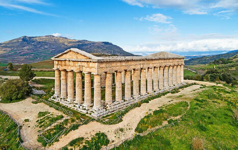


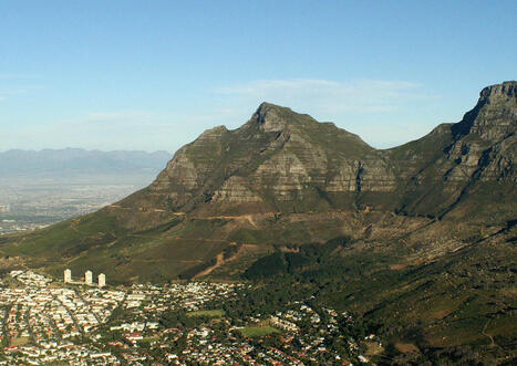


.jpg)
.jpg)
-1.jpg)
_-_How_Table_Mountain_got_its_Cloud.jpg)