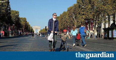

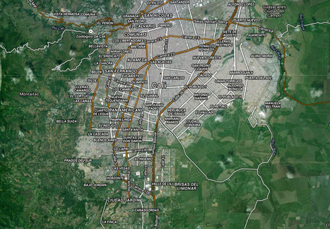
Anne Hidalgo says she wants to cut the number of cars in French capital by half as part of campaign to tackle pollution
Get Started for FREE
Sign up with Facebook Sign up with X
I don't have a Facebook or a X account


 Your new post is loading...
 Your new post is loading...
Your new post is loading...
Anne Hidalgo says she wants to cut the number of cars in French capital by half as part of campaign to tackle pollution 

Richard Aitchison's curator insight,
February 6, 2018 10:02 AM
Traffic, nobody likes to hear that word, but we are always unable to avoid it. In any major city traffic is a way of life, but how can we control it. The Mayor or Paris Anne Hidalgo has been looking for a way to limit the amount of the cars in the city or find a way to diverge traffic to some areas. Some of the reasons behind it are to address pollution issues in a city that has seen incredible increase in population and a rise in cars, which obviously gives way pollution. However, it will take time to improve public transportation and they can divert traffic as much as possible, however people still need to be able to get to work and from place to place. Also for foreigners on vacation in Paris, obviously a popular place to go, how do you deal with population problems and vacationers? Tourism is very important for Paris and there is a few concerns with cars, first off if the city becomes overtaken by smog that is never a good thing. Second, if you divert traffic to areas it may confuse travelers, and thirdly if you make major changes to roads or buildings do you change the beautiful landscape of Paris? These issues will be challenges for many Mayors or government officials all over the world, sadly there is not an easy answer.

Kelsey McIntosh's curator insight,
March 31, 2018 2:05 PM
In an effort to clear some of the traffic in Paris, the mayor has created plans that will prevent some of the traffic in the country’s capital city. She is making these plans because of the pollution that covers the city. By getting rid of half of the traffic, having an electric tram, and introducing more bike lanes, mayor Anne Hidalgo is planning to make the city “green”.
Sign up to comment
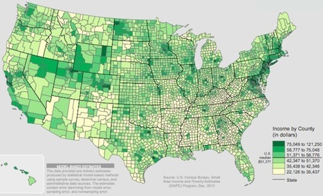
"At the county level, America is a tremendously unequal place."
GTANSW & ACT's insight:
Influences on settlement patterns. Where is Australia's population concentrated? Syllabus
I’m always disappointed that my urban acquaintances know very little of the suburbs surrounding their city. But I’m never more disappointed than when urbanites spout clichéd opinions about suburban living.
GTANSW & ACT's insight:
Perspective on suburban life

Shane C Cook's curator insight,
May 27, 2015 5:57 AM
Another testament to why gentrification is effective yet harmful to the political status of a country or area, not producing accurate results to fit the people's needs. 
Timothée Mariau's curator insight,
December 13, 2015 12:28 PM
Cet article parle de la gentrification dans le quartier d'Highland Park à Los Angeles. Ce quartier est un quartier avec une population majoritairement hispanique est constitué durant les dernières années une enclave résidentielle pour les habitants. Ce quartier était un symbole de la ségrégation raciale que connaissent une partie des villes américaines avec une concentration d'une seule population d'une seule origine ethnique dans le même quartier sans mixité sociale. Mais ces dernières années le quartier a été touché par un processus de gentrification qui a été plutôt bien accepté par les populations du quartier car cela a apporté de la mixité sociale dans le quartier avec l'arrivée de populations plus aisées provenant de différentes communautés et qui ont également créé des commerces dans le quartier. Cette gentrification qui est la plupart du temps vue d'un mauvais œil par les anciens résidents du quartier est ici acceptée car elle bénéficie en partie à la population du quartier, de plus la communauté hispanique est très importante culturellement et le fait savoir. Il y a donc une intégration des nouveaux arrivants mais en gardant tout de même l'identité originelle du quartier qui est très forte. 
Andrea J Galan's curator insight,
February 23, 2016 12:24 PM
Andrea's Inshight: I feel like the author is trying to make himself sound a little bit above the "barrio" when he says "multiethnic mount Washington". And then continues by sarcastically mentioning the charms and dysfunctions of the neighborhood. At first I was put off because I've never viewed HLP as a barrio. When I see that word I think of a ghetto slum. Which I don't think my nieghboorhood ever is. I've always viewed it as a working class neighborhood. I just dont like the barrio I think it puts a negative connotation towards the neighborhood.
Urban planners are finally recognizing that streets should be designed for people, not careening hunks of deadly metal. After over a hundred years of living with cars, some cities are slowly starting to realize that the automobile doesn't make a lot of sense in the urban context. It isn't just the smog or the traffic deaths; in a city, cars aren't even a convenient way to get around. Now a growing number of cities are getting rid of cars in certain neighborhoods through fines, better design, new apps, and, in the case of Milan, even paying commuters to leave their car parked at home and take the train instead. Unsurprisingly, the changes are happening fastest in European capitals that were designed hundreds or thousands of years before cars were ever built. In sprawling U.S. suburbs that were designed for driving, the path to eliminating cars is obviously more challenging. Read further for more on the leaders moving toward car-free neighborhoods. Via Lauren Moss
How lopsided the the proportions of an urban street corner really are. Most roads in the US are built for cars, not for pedestrians. Whether we're happy or unhappy with this, most of us are aware of it. But this brilliant illustration, made by Swedish artist Karl Jilg and commissioned by the Swedish Road Administration, shows just how extreme the situation truly is — even in an urban business district that's designed with pedestrians in mind. Tags: urban, transportation, planning, art.
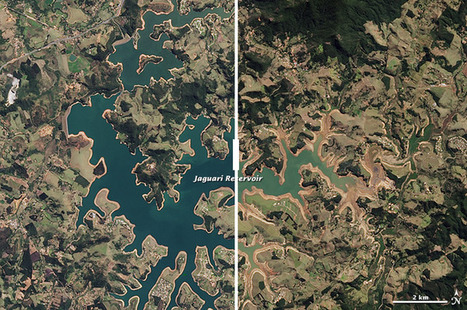
Thanks to the worst drought in eight decades, millions of people in São Paulo are facing water outages. Tags: Brazil, urban, water, urban ecology, climate change, environment depend, sustainability, agriculture, food production.

Jake Red Dorman's curator insight,
November 25, 2014 12:49 PM
Brazil’s largest city, Sao Paulo, which provides one third of the countries GPD, is now running low or water due to one of the worst droughts in 8 years. There are more than 21 million people in this city and 13 million of them are facing water outages. If it doesn't rain soon, the city could face a collapse. The city has blamed the drought of lack of water in the vapor clouds that the amazon usually provides to the city. They also blame it on deforestation and global warming. President Dilma Rousseff has questioned the cities misusage of their water supply, claiming that the city mismanaged their water supply. 
Lydia Tsao's curator insight,
March 23, 2015 10:16 AM
This shows just how important water is the human race. It also shows how humans have no sense of urgency in conserving water until it's too late. The saying "you never know a good thing until it's gone" applies in this case. The Brazilian government did not take any sufficient measures to conserve water until it realized how depleted the reservoir is. This event demonstrates the environmental impact of water depletion on humans, and how humans have such a huge impact on the geographical landscape on Earth. As seen in the picture above, many greens turned yellow as a result of the lowering water levels. The river beds are soon going to be overgrown by shrubbery as water no longer exists there. These are all results of a combination of natural (lack of rain) and human causes of resource depletion.
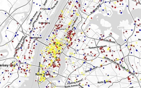
Watch the commuting patterns of New York, San Francisco and Los Angeles.
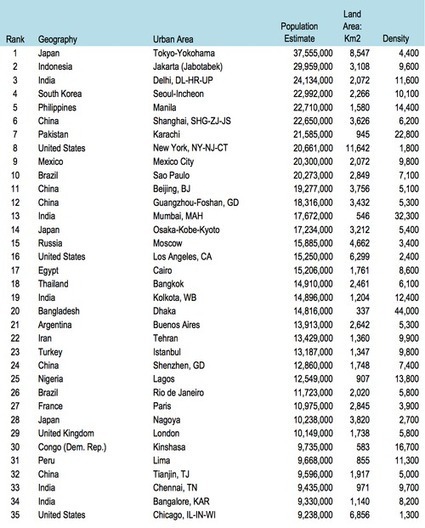
Without a question, we are living in an urban era. More people now live in cities than anywhere else on the planet and I’ve repeatedly argued that cities are our most important economic engine. As a result of these shifts, we’re seeing megacities at a scale the world has never seen before.

Sally Egan's curator insight,
June 29, 2014 9:31 PM
Mega cities and the challenges they face for the future is focus in this article. Great statistics on populations and urban densities are also included.
"About 10,000 years ago, hunter-gatherers, aided by rudimentary agriculture, moved to semi-permanent villages and never looked back. With further developments came food surpluses, leading to commerce, specialization and, many years later with the Industrial Revolution, the modern city. Vance Kite plots our urban past and how we can expect future cities to adapt to our growing populations."

Mirta Liliana Filgueira's curator insight,
June 5, 2014 2:37 PM
La urbanización Y EVOLUCIÓN De Las Ciudades.
"In the above poster the cities are arranged (roughly, in order to maximize space) by population. Clearly, size and population are not directly correlated. Some cities take up a lot more space for a smaller population. The relationship between the two, of course, is known as density (population density, urban density)."

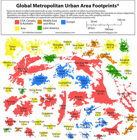
Jason Wilhelm's curator insight,
May 22, 2014 12:21 PM
Urban sprawl is a rising problem in the world due to the lack of control and its massive impact on the surrounding environment. These footprints show how unique each city's sprawl is. The surrounding environment is playing a huge role in where and how far each city extends. Chicago, for example, is limited on its eastern side due to Lake Erie's close proximity, and Cleveland is in a similar situation but on its north side where Lake Erie is. 
Sid McIntyre-DeLaMelena's curator insight,
May 29, 2014 12:35 PM
The cities are organized (approximately) to population and shows the size of cities accordingly. The different sizes of cities and their correlating populations is thus revealed from urban places around the world. Urban regions stay rather functional and could be seem similar across the board, focusing on major economic activity and transportation.
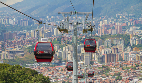
In a mountainous suburb of La Paz, Bolivia, crews are finishing the first leg of a network of gondolas, which may be the largest mass transit cable-car system in the world. Cable-car systems are hardly new tech—they are a fixture in ski resorts and mountain villages around the world. But planners are increasingly exploring their use in urban transportation systems—particularly to solve “last mile” issues, where it is difficult to connect neighborhoods to the existing mass transit network... Via Lauren Moss

GTANSW & ACT's curator insight,
April 19, 2014 3:10 AM
Australian Curriculum Geography - enhancing liveability through transport to increase social connectedness. Social connectedness influences liveability.
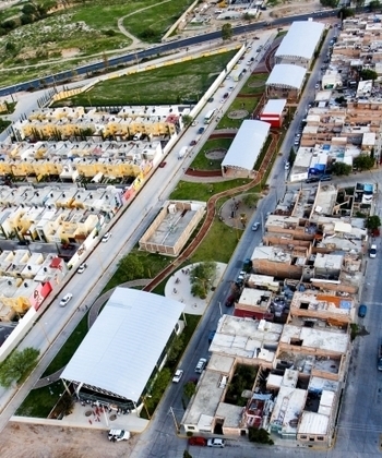
"Many good things are happening along a sliver of land that cuts through a crowded corner of Aguascalientes, a city of 1.3 million people. Fields strewn with garbage and a haven for criminals, followed the narrow path of an underground oil pipeline that traverses one impoverished neighborhood after another. In the past three years, the city has reclaimed almost all of this passage for the 300,000 people who live near it. The result is a 7.5 mile linear park that is one of Latin America’s most extraordinary urban green spaces: La Línea Verde — The Green Line."

Alec Castagno's curator insight,
October 3, 2014 1:45 PM
This article illustrates how urban renewal can be carried out without the negative effects usually associated with gentrification. The local government did this by working directly with the residents to ensure the improvements made directly reflect the needs and desires of the people that live there. It led to an improved area that not only provided activities and facilities for the locals but helped reduce the criminals and other unsavory characters that frequented the areas before. As the mayor in the article states, the park worked so much better than the common "policy of more cops and guns". 
Alyssa Dorr's curator insight,
December 16, 2014 9:20 PM
This article starts off with a story about a four year old girl named Jessica Lopez. Jessica has suffered severe asthma attacks since she was born. Her condition always worsened in the fall, due to dust rising up from the abandoned fields that bordered her family’s one-room house. Last year, city officials turned the dusty fields next to her house into a beautiful park with trails, playgrounds and shaded pavilions. Oddly enough, Jessica's asthma did not come back that fall. Her mom insists that the creation of this parked saved her life and I couldn't agree more. Most of the pollution and dust were taken out of the environment, thus making it easier for Jessica to breathe. Jessica is just one person that got help out of this. However, the amount of people in that area is equivalent to about 1.3 million. It has to have helped millions of other people as well. The park's lawn are kept nice and green and watered. Solar powered lamps are used to light the park up at night and the park is a great afternoon spot for children and their families. 
Rachel Phillips's curator insight,
February 12, 2015 6:44 PM
Personally, I love stories like this. These people took something that wasn't doing anyone any good, and was just sitting there, and turned it into something that brought the community together. This park brought life to a poor area, even though they really didn't have the means or the money to do so. However, this park can have so many benefits, and it can become an outlet. It can lower crime rates, promote health, bring in people from other cities, etc. |

Walk on the streets and you´ll be exposed to its informal economy: people who do what they can to eke out a living including washing windshields, selling food, or even singing, dancing, and performing acrobatics for a tip.
GTANSW & ACT's insight:
Contrasts found in large cities

Corey Rogers's curator insight,
December 14, 2018 5:58 PM
Most of the time when you think of Mexico you hear poor and unsuccessful cities and countries. But that is not entirely true because Mexico City is a very successful Primate City and is one of the wealthiest places to be. People need to be more mindful and do more research before making assumptions.
"The evolving role of cities and regions presents planning challenges as urban areas are work to achieve particular social, economic and environmental goals. This video explores a range of cities to examine how fully integrated planning, design, engineering and management capabilities can help to improve cities." Tags: urban, planning, urbanism, architecture.

Adam Deneault's curator insight,
December 14, 2015 9:15 PM
Definitely a good way for multi-purpose land use. They are utilizing the space they have conservatively, they really nailed this one on the head coming up with an idea to put a market right on a railroad track. Is this concept even safe or sanitary? Most definitely not. First off, it is not sanitary because that train on a daily basis has gone through all sorts of dirt and the train is literally passing right over the farmer's food that he is still going to sell to customers. Also, probably not the safest, because the people are just inches away from the passing train and with the wrong move, they can possibly fall onto the track and they are dead. I will hand it to them though, they act in an orderly fashion and move swiftly both when it comes and when it leaves. As a matter of fact, they go on with life so well after it leaves, it is almost like the train never passed through in the first place.

Nicole Canova's curator insight,
May 2, 2018 2:57 AM
In one video we see issues surrounding urban development, city planning (or lack thereof), population density, and land use, among other topics. As more and more people move into Southeast Asia's unplanned cities, there will be more crowding and people will have to use every last available inch of land, even if that means going right up to the train tracks. This is a culture shock to people in the West, where most land is single-use only.

Taylor Doonan's curator insight,
May 3, 2018 12:16 PM
Urban planning in a rapidly urbanizing area can be difficult, but in this area two very different urban entities use the land together so beautifully. This market was built around the train tracks and when the train passes through at a slow speed the market clears the tracks and both work together so flawlessly. This is uncommon for us to see because many cities in America had room to grow and expand and had ample planning time because urbanization happened much slower than it is in Asia, with urbanization happening so fast the countries need to use their space flexibly.

In James Howard Kunstler's view, public spaces should be inspired centers of civic life and the physical manifestation of the common good. Instead, he argues, what we have in America is a nation of places not worth caring about.

Zeke Robinson's curator insight,
May 26, 2015 9:23 PM
i disagree with this guy, for suburbs bring us close and save space and its good that we have them.
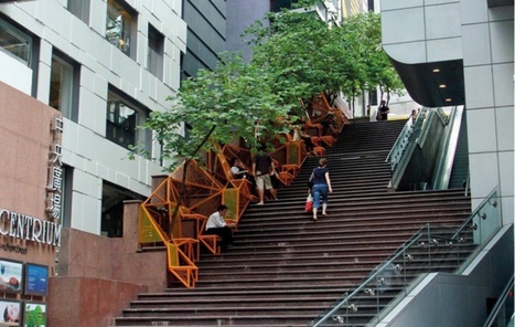
Curated by urban strategist Scott Burham, the latest exhibition at theDAC explores the array of untapped potential in our urban environments. Through installations such as a light therapy bus stop and a billboard that converts humidity into drinking water, the show will consider how infrastructure can encourage human interaction, perform alternative functions or assume an entirely new role. Via Lauren Moss

Norm Miller's curator insight,
December 30, 2014 3:38 PM
Design can make a huge difference in terms of livable cities.
Just how much of the world's cropland can we really call urban? That's been a big mystery until now. Now, a study published in the journal Environmental Research Letters has an answer: Somewhere around 1.1 billion acres is being cultivated for food in or within about 12 miles (20 kilometers) of cities. Most of that land is on the periphery of cities, but 16.6 percent of these urban farms are in open spaces within the municipal core.

Evan Margiotta's curator insight,
March 20, 2015 2:42 PM
This is a perfect application of how Von Thunen model still applies today. Von Thunen mapped how crops were distributed around cites. The crops near the city were labor intensive while the crops farther away from the city were labor extensive. Von Thunen's model is often disputed today in a world with such fast transportation, but this study shows that it still applies today. Unit 5 Agriculture 
Ellen Van Daele's curator insight,
March 22, 2015 3:34 PM
This research explores the concept of urban agriculture and the water supply needed and used. It came up with surprising results that state that 80% of urban agriculture is in the developing world and 40% of urban agriculture is in or near cities.
The research also covered water supply, stating that most of urban agriculture relies on irrigation. This is especially true in South Asia, and since the water resources are already scarce, the farmers have to compete for water with the government. 
Raychel Johnson's curator insight,
March 22, 2015 7:55 PM
Summary: This article is mostly about how much of our agriculture is grown within 20 miles of a city. It turns out 40% of agriculture is grown in this proximity of a city, and this mostly occurs with irrigated agriculture in South Asia. Most of these urban farms are in the developing world as well.
Insight: This article relates to the von Thunen model because it directly talks about the rings that occur around a city, although it is a skewed version of it. I think this is also a good example of how cities have changed since the developing of the von Thunen model, showing that developed countries are supporting the idea of urban agriculture.

"By 2025, the developing world, as we understand it now, will be home to 29 megacities. We explore the latest UN estimates and forecasts on the growth of these 'cities on steroids', and take a look at the challenges and opportunities megacities present for the tens of millions living in Lagos, Mexico City and Dhaka."

Katelyn Sesny's curator insight,
October 31, 2014 11:48 AM
This article asks and answered the question of how and when we will reach a time and place where we live will be limited (as we weigh down the world)? -UNIT 1
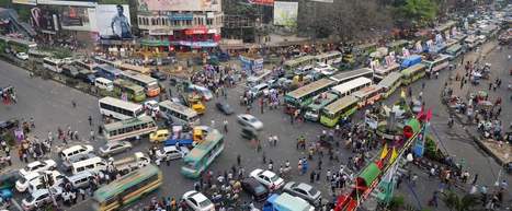
There are only 650 major intersections here—but somehow only 60 traffic lights.

Sarah Cannon's curator insight,
December 14, 2015 9:50 AM
Its amazing how much traffic can affect air pollution, especially in such a small place. Dhaka is heavily populated, traffic in this small but heavily populated community is very stressful, even to look at in the photo provided above. I can't imagine living in such a heavily populated area. I guess you can compare it to downtown New York City. However the pollution is more intense in Dhaka than it is in NYC. 
Matt Ramsdell's curator insight,
December 14, 2015 3:35 PM
This is a prime example of a megacity and the population that it cohabits the city. The huge populaiton that is se densley populated in such a small area creates for a large traffic and pedestrian issues. After watching the video you would think that there would be more accidents but living in a city like this you would get use to the population ways and learn the ways of life. 
Alex Vielman's curator insight,
December 15, 2015 12:28 AM
Dhaka, the capital of Bangladesh, suffers from overpopulation. As funny and nerve-wrecking this video was, it shows an instability on how important technology is in order for safety. In the video we can see cars just passing by fast and furociuosly within centimeters of crashing in the car in front of it. There is no one guiding traffic and nonetheless, any stop and traffic lights on the streets. It is a free for all in the middle of the capital when it comes to driving and this is a lack of safety for the people in Bangladesh. It is almost impossible for people to cross the road without a high risk of getting driven over. We can also see how there are so many cars in the are was well. The region is very overpopulated and to think how worse it would be if everyone in the area owned a car.
"About 10,000 years ago, hunter-gatherers, aided by rudimentary agriculture, moved to semi-permanent villages and never looked back. With further developments came food surpluses, leading to commerce, specialization and, many years later with the Industrial Revolution, the modern city. Vance Kite plots our urban past and how we can expect future cities to adapt to our growing populations."
Mirta Liliana Filgueira's curator insight,
June 5, 2014 2:37 PM
La urbanización Y EVOLUCIÓN De Las Ciudades.
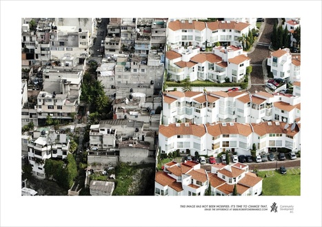
A new advertising campaign is seeking to draw attention to the gap between the wealthy and the poverty-stricken in Mexico by showing how they co-exist in disturbingly close proximity.
Alec Castagno's curator insight,
October 3, 2014 1:21 PM
The pictures show the deep divide between rich and poor in Mexico. These settlements are built to the point where luxurious condos share a wall with decaying slum housing. The roads do not connect the areas, showing how these places were constructed separately by to distinctly different communities. While the proximity between sections shows that sights, sounds, and smells most likely carry across the two sections, the rich area looks as if it has no idea what lies directly beyond their walls. The fact that the rich areas are literally walled off from the rest of the surrounding area says a lot about the deep economic divides found around the world today.
Alyssa Dorr's curator insight,
December 16, 2014 9:02 AM
Right away from looking at this picture, you can tell which side is which. I didn't even have to read the article yet to find out where the wealthier people lived and where the not so wealthy lived. The colors stood out the most to me. In the picture on the left, it is clear that this is the not so wealthy part in Mexico. The color is just filled with dark and gloominess, mostly shown in gray. The houses are also pushed very closely together. On the right side, it appears that this is the richer side of Mexico. Although the houses are closer together like the picture on the left, they are colorful. They have firm built roofs and appear to be built and taken care of much better. Something else that gives you the sense of which community is more rich is the cars. There is a whole line of cars in the right picture while in the left picture we see a few here and there. The right picture also illustrates lawns. We slightly see some grass in the left, but it is clearly not as well taken care of as the lawns in the right picture. This picture was done as an advertisement to draw attention to the gap between the two different communities. The campaign goes by the name "Erase the Differences" and hopes to get people to realize the differences in poverty that are right in front of them.

"Tracking changes in the shape of American cities over 10 years reveals which cities pack the most into a small space, but don't worry, sprawlers: Los Angeles shows you can change your fate." Today’s nearly 314 million U.S. residents will expand to 401 million in less than 40 years. Wherever you fall on the cultural spectrum between country and city mouse, the fact remains that we simply won’t be able to use up resources the way we do now in sprawling suburbs shaped by car culture. Tags: density, sustainability, housing, urban, planning, unit 7 cities.
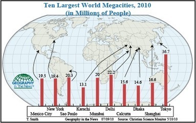
"For the first time in human history, more of the world’s 6.8 billion people live in cities than in rural areas. That is an incredible demographic and geographic shift since 1950 when only 30 percent of the world’s 2.5 billion inhabitants lived in urban environments. The world’s largest cities, particularly in developing countries, are growing at phenomenal rates. As a growing landless class is attracted by urban opportunities, meager as they might be, these cities’ populations are ballooning to incredible numbers. A May 2010 Christian Science Monitor article on “megacities” predicted that by 2050, almost 70 percent of the world’s estimated 10 billion people—more than the number of people living today—will reside in urban areas. The social, economic and environmental problems associated with a predominantly urbanized population are considerably different from those of the mostly rural world population of the past."

Colleen Blankenship's curator insight,
September 5, 2018 10:04 AM
What observations can you make about where the largest cities are? What will be the impact be of these areas in terms of resources such as housing, power, food, etc.? Where will you choose to live? |