"Today, to the southeast of Block Island, there are five new structures rising from the ocean. These are the towers of the Block Island Wind Farm, the first offshore wind energy installation in the United States. The turbines will generate 30 megawatts of energy; providing electricity to 17,000 households on Block Island and coastal Rhode Island (McCann, 2016), and replacing the diesel generators that previously powered the town New Shoreham."
Seth Dixon's insight:
One of the overriding, major take-home points of this ESRI StoryMap, is that a project of this scale, scope, and magnitude requires geographic data across many disciplines (to see the largest off-shore wind farm in the world, click here).
As a part of a national map competition sponsored by ESRI, Rhode Island is having it's own statewide map competition for students. All Rhode Island public, private, or home-schooled students (grades 4-12) are eligible to enter the contest. Maps can be submitted individually or as a team of two students.Limit of one entry per student or team.
Challenge: Your challenge is to create an original Rhode Island based map on a topic of interest or concern to you. The area mapped can range from the entire state to a smaller area, like a county or city. As an ESRI competition, you must use ArcGIS Online to create your original map. See the promotional flyer here and access more information on the competition website.
Tax credits. Lower cost of living. Restaurants and beaches. And don't forget Roger Williams and his experiment in protecting everyone's liberty of conscience.
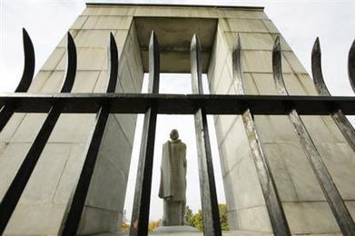
One of Colonial America's most important freethinkers has a new role as a marketing tool for the place he settled 380 years ago.
Rhode Island started out as a refuge for dissidents experimenting with revolutionary ideas that formed the backbone of U.S. democracy. Now, the tiny state is invoking its roots to draw and retain educated young people searching for a community that matches their ideals.
"Young people want to live in a place that's tolerant and diverse and inclusive," Gov. Gina Raimondo said during an interview at the Roger Williams National Memorial , which commemorates the minister and his advocacy for individual freedom. "This is part of who we are. It's not a fad or something temporary. It's ingrained in who we are as Rhode Islanders."
The Democratic governor views those principles through the lens of economic development. When PayPal announced it was halting plans to open a North Carolina branch because of that state's law blocking transgender people from using the bathroom of their choice, she called up the San Jose, California-based company and asked it to move to Rhode Island instead. Her appeal included a reference to the founding ideas of Williams' colony.
The Giant Map of Rhode Island is officially in the schools now! A huge thanks goes out to Artena Fairbairn of Robertson Elementary School (Warwick) for leading the alliance initiative to bring this 16x24 foot map to Rhode Island Schools. If you are interested in getting the map, please email sdixon [at] ric [dot] edu with the subject line “Giant RI map” to request the map to come to your school. Please include 3 weeks that would work best for your school schedule.
Check out a list of all the museums participating in Smithsonian's Museum Day Live. 46 museums in Massachusetts will offer free admission for the event.
Seth Dixon's insight:
Not in Rhode Island, but within striking distance.
Due to popular demand and support from ESRI, the RI Geography Education Alliance will have another series of workshops to help educators learn how to bring online mapping skills into the classroom. In 2015, Lyn Malone and Seth Dixon ran this as a week-long summer institute. Not everyone has a week in summer, so some have asked to have this presented on the weekends. These sessions will be condensed into two full-day workshops this fall; they will be on October 22 and 29. Participants that complete either of the 2-day workshop will receive a $100 stipend as well educational materials that will help bring GIS into the classroom. Lunch and some light breakfast refreshments will be provided. If you want to receive more information about these workshops or register, click the following link to fill out your application and reserve your spot: http://eepurl.com/cawr7D
There are few sights more heartening than that of an elementary school whose classrooms and hallways are decorated with world maps. Yet teachers should be careful to make sure that the standard depiction of the world map is not the only map their students encounter. Otherwise, they run the risk that children will assume “this is the way the world looks,” rather than the more complicated reality that “this is one of many ways of representing our world.” One useful antidote to this way of thinking is for students to explore cartograms, which are maps that use the relative area of places to present statistical data.
Saturday, July 9, 2016 8:30am - 5:30pm Don't worry, you don't need to Nature Watch for the entire duration (or have any special wildlife skills) - this isn't an endurance challenge, just some wildlife fun!
Do you love to explore and examine the natural world? Want to be a citizen scientist? Join the Museum of Natural History on Saturday, July 9, for our first annual Roger Williams Park Nature Watch, a fun ecological monitoring initiative aimed to gather information about Roger Williams Park and its inhabitants. Designed to develop scientific observation and data collection skills, Nature Watch is suitable for all levels and interests. Help contribute to the pursuit of knowledge and sign up today! Special orientation on Saturday, June 25, 11am-12pm. There is no fee to participate in the RWP Nature Watch or orientation.
More information coming soon! Contact the museum, 401.680.7221, to learn more about this special event!
""The 2015 Global Peace Index reveals a divided world, with the most peaceful countries enjoying increasing levels of peace and prosperity, while the least peaceful countries spiral into violence and conflict. Explore the state of world peace on the interactive Global Peace Index map. www.visionofhumanity.org "
Seth Dixon's insight:
The Middle East and North Africa is now the world’s least peaceful region for the first time since the Index began, due to an increase in civil unrest and terrorist activity while Europe, the world’s most peaceful region, has reached historically high levels of peace. This might not seem shocking, but there is a great richness to this dataset that can provide detailed regional information as well as answer some big questions about global security. Explore the data on your own with this interactive map of Global Peace or also of the states within the United States.
"Individuals who join or renew their NCGE memberships through this new program will receive all the benefits of membership plus an additional conference registration discount, all for the low annual membership rate of $50 for as long as the partnership remains in effect. Rhode Island Geography Education Alliance (RIGEA) members are all automatically members of the New England Geography Education Network (NEGEN)."
Seth Dixon's insight:
Partnership enables the New England Geography Education Network and the National Council for Geographic Education to combine unique strengths to develop a more focused approach to support the status and quality of geography education throughout the New England region (all RIGEA members are all automatically members of NEGEN). The NCGE-NEGEN partnership recognizes our common goals, and through our joint membership program, we provide complementary support, benefits and opportunities for geography educators in Connecticut, Maine, Massachusetts, New Hampshire, Rhode Island and Vermont. The partnership provides an opportunity for collaboration on major advancements in curricula and classroom resources, professional development, professional recognition, research, and outreach.
I am excited to see the full kit that National Geographic and Alliance leaders have put together. There are some fun lessons and plenty of room to individualize the activities and be as creative as you want to be. Here are some of files to explain the supplemental materials that are in the trunk (besides the map of course!).
The share of local workers with jobs in manufacturing plunged from 40% in 1980 to 11% in 2014, a Fed researcher reports.
A new study illustrates just how drastically employment has plunged in Rhode Island’s historic industrial base over recent decades. Since 1980, the Providence metropolitan area has experienced the largest shift in the country away from manufacturing jobs and into work requiring college degrees, according to a paper by Stephan Whitaker, a research economist at the Federal Reserve Bank of Cleveland. “In 1980, 40% of workers in the Providence metro area worked in manufacturing and 25% worked in degree-intensive fields,” Whitaker writes. “By 2014, manufacturing had dropped to just 11%, and degree-intensive jobs had risen to 47%.”
Resources about Roger Williams and his teachings to establish a sense of place, awareness, and pride for all Rhode Islanders.
Explore our collection of resources organized by topic areas related to Roger Williams's life and teachings. View essays, videos, galleries, educational activities, lesson plans, or discussion starters in each of the topic areas below.
There is still space in the Alliance's Oct 22nd and 29th mapping workshops. If you are new to digital mapping, this is for you. If you are hoping to deepen you ArcGIS online mapping skills, this is for you. Social studies, environmental science, STEM...all are welcome. Sign up and invite another educator! Registration: http://eepurl.com/cawr7D
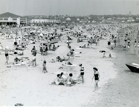
This map is a great archive of historic satellite imagery of the Ocean State, with a special nod to Providence. This is a great tool that can be used to show how and particular place in Rhode Island has changed over the years at the neighborhood scale. At the metropolitan scale, it is easy to see the population grown, development expansion, and urban sprawl. The years of data coverage are 1939, 1952, 1962, 1972, 1981, 1985, 2003, 2008, 2011, and 2014.
Check out Election Central from PBS with tools, resources & solutions to engage students in the political process.
Seth Dixon's insight:
The first presidential election last night has intensified the already polarized political conversation in the United States. This is a great resource to explore historic political maps and cartograms. It also has rich tools to project the possibilities for the 2016 election with ready-made lesson plans.
"Coming in dead last on the 200 cities measured: Boston, for the second year in a row. Boston has company. Worcester came in at No. 199, second up from Boston's position in the 200th slot. Boston and Worcester have basically been battling it out for last place in Allstate's rankings since 2014. Springfield makes a poor showing, too, at No. 196."
Seth Dixon's insight:
Don't get too excited by the news Rhode Islanders...Providence was the 194th ranked city and the state is typically the 49th ranked state. Given some on my experiences in the Ocean State, 49th might be a generous ranking.
Free Educational Seminar and RIGIS User Group Meeting
There is a wealth of aerial and satellite images of Rhode Island that are freely available online. Tapping into them can be challenging if you're unsure where to look and if you're not familiar with some basic tools and techniques to view them.
This half-day seminar will introduce you to a number of online sources of image data for Rhode Island, with a special emphasis on data available from the Rhode Island Geographic Information System (RIGIS) consortium, USGS, and NOAA. We will also highlight a suite of new image services featuring RIGIS data that are now under development by Rhode IslandView.
YOU will guide the techniques highlighted in this seminar. Vote for the technique you are most interested in learning about by registering for this event now: http://bit.ly/RIimagery_Aug19
#StraightOuttaLittleCompton! Little Compton, RI is the most rural township/municipality in #rhodeisland. On the very far southeastern side of #narragansettbay, its a forgotten corner of the Ocean State. It's a classic New England village that still has a thriving general store as the center of commercial life in the village. I highly recommend biking to explore this delightfully quaint community of yesteryear (although it's charm will transform it--construction/development projects can be seen quite frequently). #cycling#oceanstate#bikeri#newengland#landscape#LittleCompton
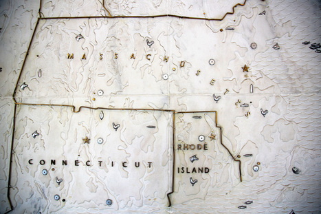
If you’re interested, you’ll need a really big wall.
Just inside the grand, arched entryway to The Boston Globe’s headquarters, there is a map like no other. It’s a two-story-tall, three-dimensional relief map of New England carved out of huge slabs of white marble. And it’s gorgeous.
The map was commissioned for a 1953 addition to the Boston Fed’s headquarters on Pearl Street. The Boston Fed building was razed in 1978 after the bank moved. This is when the map came to TheGlobe’s headquarters, where it has greeted journalists on their way to the newsroom for the last 38 years.
"Andrea Wulf's new book The Invention of Nature reveals the extraordinary life of the visionary German naturalist Alexander von Humboldt (1769-1859) and how he created the way we understand nature today. Though almost forgotten today, his name lingers everywhere from the Humboldt Current to the Humboldt penguin. Humboldt was an intrepid explorer and the most famous scientist of his age. Perceiving nature as an interconnected global force, Humboldt discovered similarities between climate zones across the world and predicted human-induced climate change. Wulf traces Humboldt’s influences through the great minds he inspired in revolution, evolution, ecology, conservation, art and literature. In The Invention of Nature Wulf brings this lost hero to science and the forgotten father of environmentalism back to life."
Seth Dixon's insight:
Alexander von Humboldt's biographer Andrea Wulf is coming to Rhode Island on May 9th to speak about the greatest scientist that people don't know about. Alexander von Humboldt has been described as the last great ancient geographer concerned with understanding an eclectic cosmography as well as the first modern geographer. He is honored far and wide throughout Europe and especially Latin America for his explorations, but given that people are confused as how to categorize him and classify his contributions, today he is under-appreciated. Geographers need to reclaim his memory and call his extensive, globetrotting work on a wide range of subjects ‘geography.’ Here are more articles and videos on the man that I feel geographers should publicly champion as their intellectual ancestor the way that biologists point to Darwin.
To get content containing either thought or leadership enter:
To get content containing both thought and leadership enter:
To get content containing the expression thought leadership enter:
You can enter several keywords and you can refine them whenever you want. Our suggestion engine uses more signals but entering a few keywords here will rapidly give you great content to curate.


 Your new post is loading...


One of the overriding, major take-home points of this ESRI StoryMap, is that a project of this scale, scope, and magnitude requires geographic data across many disciplines (to see the largest off-shore wind farm in the world, click here).
Tags: mapping, Rhode Island, ESRI, StoryMap, GIS, resources, water, coastal, energy, environment depend.