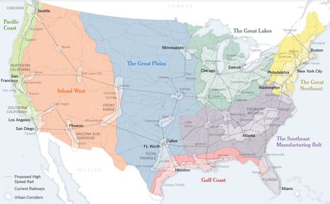
The 50-state model is holding the country back. It needs a new system, built around urban corridors.
Get Started for FREE
Sign up with Facebook Sign up with X
I don't have a Facebook or a X account


 Your new post is loading...
 Your new post is loading...
Your new post is loading...
The 50-state model is holding the country back. It needs a new system, built around urban corridors. 

Jean-Simon Venne's curator insight,
April 28, 2016 8:13 AM
We should build a similar map for technology innovaton

Character Minutes's curator insight,
July 1, 2016 7:13 PM
Great way to encourage critical thinking in students: what would this impact? Adv & Disadvantages? Compare 50 states vs this model? How would new plan be implemented?

Alex Smiga's curator insight,
August 30, 2016 2:26 PM
...and back to city states?
Sign up to comment
Watch the commuting patterns of New York, San Francisco and Los Angeles.
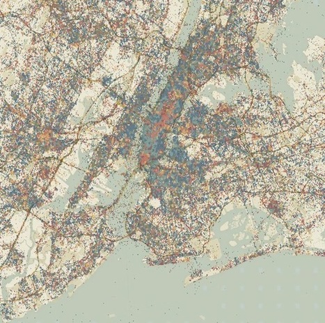
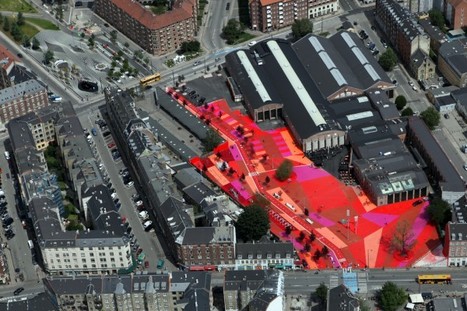
An EU-funded project is building platforms to detect patterns in how people use urban spaces.
Maps don't typically convey time very well. They're static snapshots of a moment in history. A handful of animated maps that do a good job combining time and space using either transit data or geo-tagged social-media hits. Now a new project, called Geographies of Time, is trying to do something similar with a more typical two-dimensional map. The effort is part of a broader EU-funded projects called UrbanSensing that's building platforms to detect patterns in how people use urban spaces. Via Lauren Moss

luiy's curator insight,
November 28, 2013 6:21 AM
Giorgia Lupi, the Ph.D. researcher at Milan Politecnico behind the project, began with Milan. Using tens of thousands of geo-tagged tweets, she and colleagues divided the map of the city into a fine-grained grid. The tweets were then divided into eight three-hour time intervals (from midnight to 3 a.m., 3 a.m. to 6 a.m., etc.). And the boxes in the grid were digitally colored based on the time window when Twitter was locally most active. 
nuria font-casaseca's curator insight,
April 24, 2014 9:21 AM
Les ciutats i els temps: com ens movem per la ciutat en funció de l'hora i el dia.
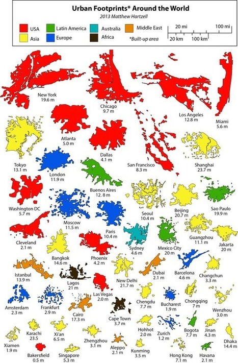
"This is a series of infographics (or geo-infographics) created by Matthew Hartzell, a friend of mine that I met when we were both geography graduate students at Penn State in few years back..."

Jacob Crowell's curator insight,
October 14, 2014 3:25 PM
This is an interesting way to graph out the urban footprints of various cities from around the world. This also shows how the United States has a number of the largest urban centers in the world. Along the top, New York, Chicago, LA, and Miami are massive compared to cities like Hong Kong. This shows how in the United States there are massive amounts of urban growth. Even in China where their population is one of the worlds biggest, Hong Kong a major city only has 7.1 million. In the United States, for the past century cities have been growing and this graph shows that. 
Samuel D'Amore's curator insight,
December 14, 2014 6:40 PM
These visuals really help to show that the size of a city doesn't necessarily correspond with it's population. Many years ago the trend was the larger the city in turn it would posses a larger population than a physically smaller city. Today this no longer holds true, in fact many smaller cities vastly out populate large sprawling cities. Most of these mega-cities in Asia and Latin America are incredibly over build and densely packed surrounded by miles of slums.
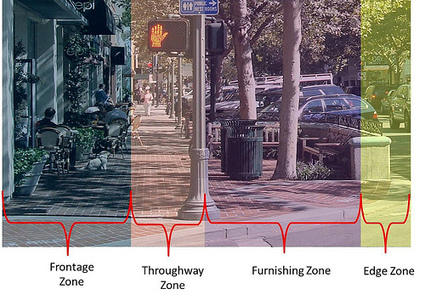
A street shouldn't just be about transportation, but also about civic definition and social and commercial interaction.
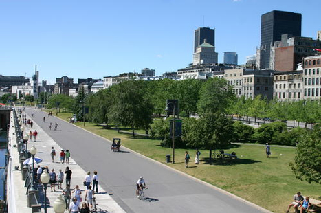
There is no better place to start using land more efficiently than with our streets, our most plentiful and visible parts of the urban commons. The recent "complete streets" movement has made a terrific contribution to getting our streets right, by insisting that they be designed so as to accommodate all users. Connectivity is hugely important to a sustainable street network to encourage walking and shorten driving trips by making destinations more convenient. The pedestrian experience should be safe and enjoyable, and should be so perceived.
Other design elements to help turn streets into worthy places are: Sidewalks with real curbs;On-street parking ;Street trees;Storefronts with elements that shelter pedestrians such as awnings, arcades, and colonnades;Buildings with windows and "other signs of human occupancy such as porches and balconies" for "eyes on the street";Design appropriate to safe motor vehicle speeds. Via Lauren Moss

Lauren Moss's curator insight,
July 17, 2013 11:57 AM
Visit the article link for more details and information on the process of creating better public spaces and the elements that make for healthy, safe and vibrant communities. 
Nienke Groen's curator insight,
July 18, 2013 8:09 AM
Nice trend: refitting streets to create connectivity

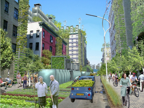
Rising sustainability concerns over the last decade have brought about a fascinating new tendency in landscape concepts for development and renewal of urban and even industrial areas. Nature is coming back to cities and that’s a wonderful opportunity for us to get back to it too. Experience the mesmerizing beauty of these nature bites inserted into urban context and let’s hope this is the future of landscape architecture! Via Lauren Moss

Lighting designers are applying the skills of their profession to further the goals of urban design, creating safer, more stimulating, and better functioning cities.
Cities rarely stand still. It is in their nature to evolve, expand, and, in some cases, contract. Whichever way they go, cities are always reinventing themselves, often one neighborhood at a time. Outdoor lighting can be a crucial part of this metamorphosis. Across the U.S., urban regeneration projects are stimulating activity in derelict infrastructure, defunct waterfronts, neglected plots of land, and dilapidated buildings. Though not completely erased, the use of fluorescent tubes and glaring security lights has been scaled back and in their place is a growing appreciation for sensitive, appropriate, and considered lighting. The arbiters of this decades-long shift are lighting designers. Their role in improving conditions to make safer, more accessible cities is increasingly key to urban design... Via Lauren Moss

Norm Miller's curator insight,
May 26, 2013 2:58 PM
Good even lighting and people make places safer. Its that simple.

From
urbantimes

It is no great revelation that architects tend to look up when exploring a city. It’s the best way to guage size, scale, placement, composition and detail – all the information required to process the qualities of a space or place.
Having spent the last few days looking up and considering the architectural impact of the New York City grid-plan layout, this article takes a particular interest in the domestic scale elements that help to service the city and punctuate the rigidity. At first the brain identifies the rhythm of the brick formation and the window layouts, it is this assumption of regularity that leaves many with this very valid conclusion based on the verticality of the grid. But in identifying this pattern – the eye becomes more accustomed, searching for further geometries or perhaps more importantly, exceptions to the rule.
Via Lauren Moss

In honor of the opening of a new garden in Paris, Reuters has pulled together a list of some of their favorite green spaces. Here are a couple favorites... Via Lauren Moss
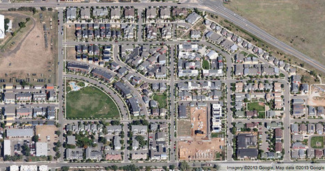
See the big picture of how suburban developments are changing the country's landscape, with aerial photos and ideas for the future Via Apres

Liam Michelsohn's curator insight,
December 10, 2013 4:13 PM
A very interesting article on changes in landscape, while looking though this I came aross so many little things i never noticed about the topical layout of housing. The main thing that is apparent is density, how closely each house is put together, the amount of land each has as well as the view from the property. Its aslo interesting to see how the design of the area can be made for easy access or be desigend to keep people out with only one enctancte and exit. All of these charasticts make up how the land is desired as well as econimcly priced, which then determins who will be able to live there. 
Jacqueline Landry's curator insight,
December 15, 2013 8:53 PM
Having the streets interconnected allows for easy traveling throughout the area. when there is more density in an area it means there are more houses , more people. The sprawl has the center on the place and the streets go out around it. The way the streets are made are for different reasons,. 
megan b clement's comment,
December 16, 2013 12:57 AM
This article talks about twenty different housing patterns and how we base these housing patterns around our society or enviroment. How looking at housing patterns can tell you what kind of neighborhood one lives in from the sky. Looking down and seeing a golf course with lush grass and big backyards shows you that this neighborhood is very expensive. Or Canal houses that utilize every inch of the waters edge to financially make them able to charge higher prices for the homes because each house has a water view and is on the waters edge.
From
ht
As more cities envision their waterfronts as lively public destinations that keep people coming back, PPS outlines the following principles to make that happen.
They are not all hard and fast laws, but rules of thumb drawn from 32 years of experience working to improve urban waterfronts around the world. These ideas can serve as the framework for any waterfront project seeking to create vibrant public spaces, and, by extension, a vibrant city. Via Lauren Moss
Lauren Moss's curator insight,
January 13, 2013 8:16 PM
Visit the article link for more information on the strategies and concepts outlined, including the following:
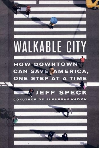
City engineers have turned our downtowns into places that are easy to get to but not worth arriving at. In Walkable City: How Downtown Can Save America, One Step at a Time (public library), city planner Jeff Speck, who spent four years leading the design division of the National Endowment for the Arts working directly with a couple hundred mayors to help solve their greatest city-planning challenges, turns a perceptive eye towards what makes a great city and how we might be able to harness the power of a conceptually simple, practically complex, immeasurably far-reaching solution in improving the fabric and experience of urban life.
Speck outlines a “General Theory of Walkability,” focusing on the four key factors of making a city attractive to pedestrians: 'it must be useful, safe, comfortable, and interesting. Each of these qualities is essential an none alone is sufficient...' Learn more about urban livability, how to create the conditions that enable pedestrian-oriented development, and the benefits of this approach to urban spaces to the economic, environmental, and cultural health of a city at the article link... Via Lauren Moss
Given the environmental straits we find ourselves in at present, architects and policy makers have to rethink our strategy of how to shape the city, buildings and urban space alike. This entails that we refrain from the strategies of the past and make do with the standing infrastructure that we already have. Preserving and rehabilitating the aging steel relics of our global cities has proven an ingenious way of saving energy, while enabling newer methods of architectural planning. Projects such as the High Line have kickstarted a new age of urban regeneration–for good or bad–with initiatives from Tel Aviv to Philadelphia attempting to replicate it success on their own turf. When it comes to urban transformation, size does not matter, per se. The subtleties of thoughtful urban projects shine through at every level, and sometime outperform their more ostentatious contemporaries.
Visit the link for photos and descriptions of 10 projects from across the globe, including public parks, infrastructure projects, cultural buildings and more... Via Lauren Moss
|
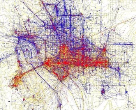
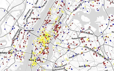
"Tourists and locals experience cities in strikingly different ways. To see just how different these two worlds are, have a look at the map of Washington D.C. above based on where people take photos. The red bits indicate photos taken by tourists, while the blue bits indicate photos taken by locals and the yellow bits might be either."
The growth of these cities will create a host of environmental and health problems.
By 2210, the global population is expected to grow from just more than 7 billion to 11.3 billion — with 87 percent of the population living in urban areas, according to a new working paper by researchers from NYU’s Marron Institute. Most of these individuals will be in what’s now the developing world — creating a host of environmental and health problems. If projections are correct, these new urban dwellers will require the world’s existing cities to expand six-fold to accommodate triple the residents, Richard Florida wrote in The Atlantic. Plus, the world will need 500 new “megacities” of 10 million or more, he wrote. Via Lola Ripollés

Valerie Bauwens's curator insight,
March 28, 2014 4:46 AM
Or will there be a natural come back to the country side? 
Jessica Rieman's curator insight,
April 2, 2014 5:42 PM
Cairo, Egypt has a population density of 9,400 residents per square kilometer. THese numbers are crazy think about it compared to MA or RI and our major cities.
Silent parks. Designing for disabilities. Human-powered data. Garbage anthropology. World-class sidewalks. Floating favelas. Paint as infrastructure. These are the keys to the cities of the future, according to the most recent TED conference, City 2.0. Last year, for the first time, the TED Prize went to an idea—the future of the city—and a million dollars was divvied up among ten grantees all over the world.
Last week was the first-ever TED City 2.0 conference, featuring several of those grantees plus many other urban leaders discussing their ideas for the future of the city. Via Lauren Moss, Raymond Versteegh, Manu Fernandez, Luciana Santos

Raymond Versteegh's curator insight,
October 6, 2013 3:36 PM
Simple ideas wrapped in big dreams. GET INSPIRED!
Not only are many cities bursting at the seams from urban overcrowding; they are also increasingly starting to bear the strains of climate change. Although there are numerous solutions to either challenge, the building up of new "eco-cities" tries to kill the two birds with one stone. But what is the role of these master-planned communities in our sustainable futures? The concept of an isolated, ecologically minded community is by no means a new one. The forward-thinking Buckminster Fuller was talking about "domed communities" in the 1960s, and in 1975 writer Ernest Callenbach published his novel Ecotopia, greatly influencing the green movements that would quickly follow. While smaller versions may have grown more organically, contemporary Eco-Cities are often top-down master plans designed by big-name firms. Since many of these Eco-Cities are still under development, we can only speculate about their future performance and whether they will be flexible enough to function as a "real city."
Visit the link to read the complete article. Via Lauren Moss
Norm Miller's curator insight,
August 12, 2013 1:43 PM
This article raises a good question. It makes more sense to retrofit existing buildings so why not existing cities?
Via Bionic City

Bionic City's curator insight,
July 16, 2013 5:29 AM
DIY Cities: Post-Industrial Urban Futures, a keynote presentation given by Design Scientist and Futurist Melissa Sterry at 'Future Cities', held on July 10th 2013 at The Biospheric Project, Salford, as part of the official programme of the Manchester International Festival 2013. To read the accompanying speech notes click http://www.slideshare.net/societas/diy-cities-post
Inspiration Kitchens in Chicago took home the Bruner Foundation’s Rudy Bruner Award for Urban Excellence (RBA) gold medal, which comes with $50,000 in support for the project. Four other projects won silver medals and $10,000. The biennial award celebrates “urban places distinguished by quality design and contributions to the social, economic, and communal vitality of our nation’s cities.” Since 1987, the Bruner Foundation has awarded 67 projects $1.2 million in support. Inspiration Kitchens is an “entrepreneurial, nonprofit initiative” on Chicago’s west side. In an economically-challenged part of the city, this LEED Gold certified facility, with a 80-seat restaurant, serves free and affordable healthy meals. Four other projects won silver medals and $10,000: read the complete article for more details. Via Lauren Moss

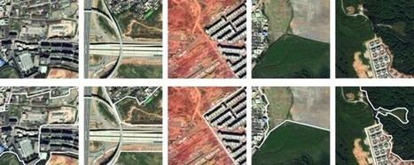
Of all the cosmic bodies studied in the long history of astronomy and space travel, the one that got the least attention was the one that ought to matter most to us—Earth. That changed when NASA created the Landsat program, a series of satellites that would perpetually orbit our planet, looking not out but down. Landsat was built for public monitoring of how the human species was altering the surface of the planet. The space agency, along with the U.S. Geological Survey (USGS), has accumulated a stunning catalog of images that, when riffled through and stitched together, create a high-definition slide show of our rapidly changing Earth, which for the first time date all the way back to 1984.
These Timelapse pictures tell the pretty and not-so-pretty story of a finite planet and how its residents are treating it — razing even as we build, destroying even as we preserve. Visit the article link to see an exclusive timelapse of climate change, deforestation and urban sprawl unfolding as Earth evolves over 30 years... Via Lauren Moss

Ishola Adebayo's comment,
July 31, 2013 9:07 AM
good day Sir, pls need help on fixing scan line errors on lansat7 ETM images from 2003 using for example ArcMap9.3 or ENVI4.5 or.........thank you so much

Courtney Barrowman's curator insight,
May 27, 2015 10:55 AM
summer work KQ2 key concepts: remote sensing, deforestation, desertification, land use, geospatial
The urban ecology framework of Patch Dynamics has been key in watching how city models such as the megalopolis and the megacity interact and generate urban ecosystem change.
Urban Design practices have always been created in response to emerging and overlapping city models and the disciplinary contexts designers find themselves in. The urban ecology framework of Patch Dynamics has been key in allowing me to see how city models such as the megalopolis and the megacity interact and generate urban ecosystem change. One's first thought about a patch may be that of a shape that changes. However, the concept of a patch in this case describes a set of patches or a mosaic that changes over time. This search is not to find or create the best patch mosaics, or those that function in the most resilient ways. Instead, it is a project of creating urban design practices and strategies for a diversity of urban actors to engage their patches and democratize the resilience cycle in their own ways. Via Lauren Moss

22 cities have called for innovative solutions to solve urban challenges as part of the Citymart urban ideas competition. The aim is to identify & share solutions to challenges that cities face.
The 2012 competition attracted 1,519 entries from 70 countries. Now Aalborg, Barcelona, Boston, Christchurch, Eindhoven, Fukuoka DC, L’Hospitalet, Lagos, Lavasa, London, Maringa, Mexico City, Oulu, Paris, Rio de Janeiro, Rosario, San Francisco, Sant Cugat, Sheffield, Tacoma, Terrassa and York all hope to evoke a similar response.
The cities have presented challenges across a vast array of areas including mobility, economic development, social inclusion, health and well-being, urban management, lighting, energy, culture, future government and sustainable lifestyles... Via Lauren Moss, Jandira Feijó

Imran Ahmed Khan's comment,
January 17, 2013 3:44 PM
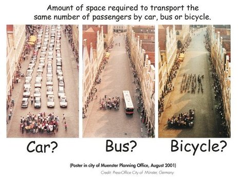
Good picture! It defines the growth of the city that impact on urbanization rate, public health, socioeconomic environment. It also tell us that if we reduce vehicles on the road more space and clean environment may we get, that reduce motality and morbadity of several disease especially lung diseases.

Lauren Jacquez's curator insight,
April 8, 2013 9:31 PM
What are the benefits for each? Drawbacks? You decide!

China's next new city will be designed by US firm KPF, next to Hunan's regional capital, around a 40-hectare lake.
Adjacent to Changsha, the ancient capital city of Hunan, the design implements the sort of urban innovation that creates a sustainable and truly habitable environment. "We can introduce integrated urban innovation," von Klemperer says, "we can combine water transport with localised energy production, cluster neighbourhood centres, advanced flood prevention and water management, and urban agriculture. Meixi is an experiment in future city planning and building. It will serve Changsha as a new CBD, but it will also serve as a paradigm for other Chinese city planners. It's a kind of live test case."
The firm seeks to achieve these goals through its dense, mixed-use urban, plan, with integration with surrounding mountains, lakes, parks and canals. Meixi Lake will eventually be home to 180,000 inhabitants, living in "villages" of 10,000 people, clustered around the canals...
Via Lauren Moss
association concert urbain's insight:
via @Territori
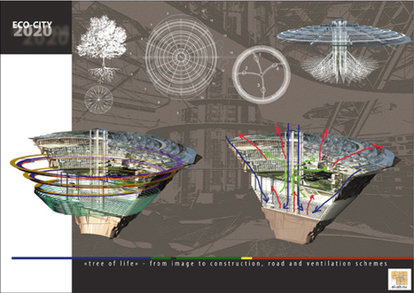
Eco-city 2020 is a proposal for the rehabilitation of the Mirniy industrial zone in Eastern Siberia, Russia designed by the innovative architectural studio AB Elis Ltd. The project would be located inside a giant man-made crater of more than one kilometer in diameter and 550 meters deep that used to be one of the world’s largest quarries. The idea is to create a new garden city shielded from the harsh Siberian environmental conditions and instead, attract tourists and residents to Eastern Siberia, with the ability to accommodate more than 100,000 people. The new city is planned to be divided in 3 main levels with a vertical farm, forests, residences, and recreational areas. One of the most interesting aspects of the proposal is the glass dome that will protect the city and would be covered by photovoltaic cells that will harvest enough solar energy for the new development. A central core houses the majority of the vertical circulations and infrastructure along with a multi-level research center. The housing area is located in the first level with outdoor terraces overlooking a forest in the center of the city, in order to create a new type of highly dense urbanism in harmony with nature.
View diagrams & renderings, and learn more about this interesting approach to urban design, sustainability and renewal at the complete article link... Via Lauren Moss, Territori
|