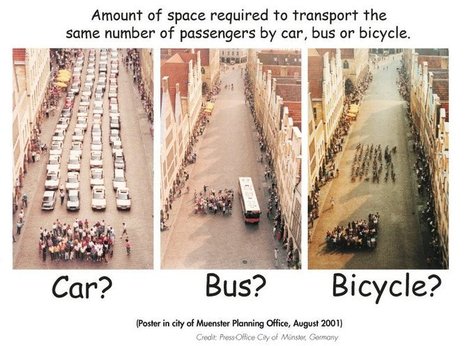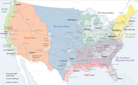
The 50-state model is holding the country back. It needs a new system, built around urban corridors.
Get Started for FREE
Sign up with Facebook Sign up with X
I don't have a Facebook or a X account


 Your new post is loading...
 Your new post is loading...
Your new post is loading...
The 50-state model is holding the country back. It needs a new system, built around urban corridors. 

Jean-Simon Venne's curator insight,
April 28, 2016 8:13 AM
We should build a similar map for technology innovaton

Character Minutes's curator insight,
July 1, 2016 7:13 PM
Great way to encourage critical thinking in students: what would this impact? Adv & Disadvantages? Compare 50 states vs this model? How would new plan be implemented?

Alex Smiga's curator insight,
August 30, 2016 2:26 PM
...and back to city states?
Sign up to comment
![[Flipboard] Bionic City magazine, September 2013 | URBANmedias | Scoop.it](https://img.scoop.it/q78tsVeOdHqHzpK6NCNrxzl72eJkfbmt4t8yenImKBVvK0kTmF0xjctABnaLJIm9)
"Completely awesome magazine on biomimetics by Melissa Sterry" Mike McCue, Founder, Flipboard Via Sergey Yatsenko, Luciana Santos
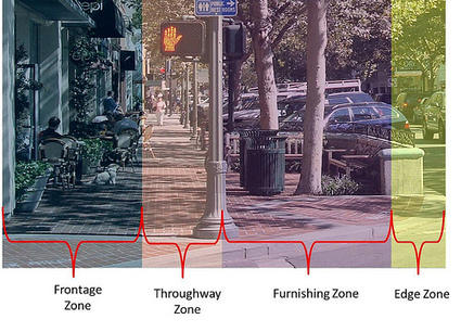
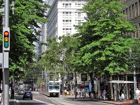
A street shouldn't just be about transportation, but also about civic definition and social and commercial interaction.
There is no better place to start using land more efficiently than with our streets, our most plentiful and visible parts of the urban commons. The recent "complete streets" movement has made a terrific contribution to getting our streets right, by insisting that they be designed so as to accommodate all users. Connectivity is hugely important to a sustainable street network to encourage walking and shorten driving trips by making destinations more convenient. The pedestrian experience should be safe and enjoyable, and should be so perceived.
Other design elements to help turn streets into worthy places are: Sidewalks with real curbs;On-street parking ;Street trees;Storefronts with elements that shelter pedestrians such as awnings, arcades, and colonnades;Buildings with windows and "other signs of human occupancy such as porches and balconies" for "eyes on the street";Design appropriate to safe motor vehicle speeds. Via Lauren Moss

Lauren Moss's curator insight,
July 17, 2013 11:57 AM
Visit the article link for more details and information on the process of creating better public spaces and the elements that make for healthy, safe and vibrant communities. 
Nienke Groen's curator insight,
July 18, 2013 8:09 AM
Nice trend: refitting streets to create connectivity

Adrian Smith + Gordon Gill Architecture, dedicated to sustainable architecture, has imagined and designed city so compact that nothing is more than a 15-minute walk away.
Dubbed “Great City,” the prototype suggests a Chinese city that might be built in 2021 on the outskirts of Chengdu, a city in the southwest of Asia. Taking up just 1.3 square miles and 320 acres, Great City could be home to 80,000 people. The project proposes that 15 per cent of the total acreage would be devoted to urban parks and green areas, 60 per cent to buildings and 25 per cent to roads and walkways. To design the world’s first pedestrian-only city, the architects considered a massive transit centre where public transport would be concentrated... Via Lauren Moss
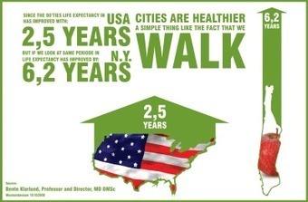
Here's a startling thought: In the years ahead, architects and planners may have a greater hand in ensuring public health than physicians will. How's that? Because by finding ways of encouraging people to walk or cycle rather than drive, city planners may be able to encourage the thing that will make us healthier, which is regular exercise. Here are some thoughts on this topic from a well-known Danish architecture firm. (Don't worry, the article is in English.)
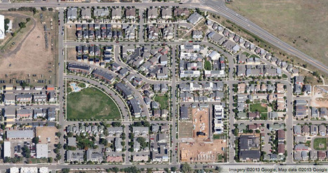
See the big picture of how suburban developments are changing the country's landscape, with aerial photos and ideas for the future Via Apres

Liam Michelsohn's curator insight,
December 10, 2013 4:13 PM
A very interesting article on changes in landscape, while looking though this I came aross so many little things i never noticed about the topical layout of housing. The main thing that is apparent is density, how closely each house is put together, the amount of land each has as well as the view from the property. Its aslo interesting to see how the design of the area can be made for easy access or be desigend to keep people out with only one enctancte and exit. All of these charasticts make up how the land is desired as well as econimcly priced, which then determins who will be able to live there. 
Jacqueline Landry's curator insight,
December 15, 2013 8:53 PM
Having the streets interconnected allows for easy traveling throughout the area. when there is more density in an area it means there are more houses , more people. The sprawl has the center on the place and the streets go out around it. The way the streets are made are for different reasons,. 
megan b clement's comment,
December 16, 2013 12:57 AM
This article talks about twenty different housing patterns and how we base these housing patterns around our society or enviroment. How looking at housing patterns can tell you what kind of neighborhood one lives in from the sky. Looking down and seeing a golf course with lush grass and big backyards shows you that this neighborhood is very expensive. Or Canal houses that utilize every inch of the waters edge to financially make them able to charge higher prices for the homes because each house has a water view and is on the waters edge.
For many years, architects and city planners from around the world have been trying to create the green ideal: an entire city built to strict environmental standards- highly functional while still retaining aesthetic value.
Here’s a look at some green building and community design that caught our attention in recent months and may (or may not) become reality in the next several years. Their physical footprints may be large, but by using features such as wind power, solar, rainwater recycling and advanced air quality controls, their carbon footprints don't have to be... Via Lauren Moss

Norm Miller's curator insight,
January 2, 2013 4:32 PM
This is going beyond Mazdar in Dubai. The reality is that we need to transform existing cities since starting from scratch is rare. We need to retrofit cities more than build new ones, but still it is interesting.
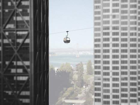
For many, aerial mass transit--either by way of tram or gondola--is an idea best left to ski resorts and World’s Fairs.
But for a growing number of urban planners and designers, aerial transit represents an alternative for cities where traditional transit options are limited. At PSFK’s recent conference in San Francisco, Frog Principal Designer Michael McDaniel unveiled an ambitious plan called the Wire, which proposes a network of gondolas over Austin, Texas. McDaniel and his team imagine a system of detachable gondolas connecting neighborhoods throughout the city, making it possible for cyclists and pedestrians to “hop” over particularly congested areas. “The big advantage here is the detachable part which means more gondolas can be added during rush hour and removed in non-peaks times,” he tells Co.Design. After looking at precedents--like dedicated bus lanes and Portland, another city whose aerial tram has been a huge success--the design team took to Austin’s streets, interviewing locals about their transit experiences... Via Lauren Moss
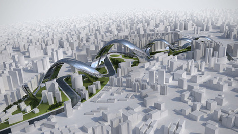
“This planning proposal seeks to determine community and bio-diversity from its historical pattern. The concept finds fundamental inspiration in the strong historical identity of the local railway line, and the historic identity of industrialization of Kaohsiung city. Inspired by the culturally and biologically responsive between the new city urban fabric and existing old town Yen Chan district, the guiding principle of the master plan is to inspire a meaningful sense of community and a shared commitment to social and environmental responsibility. The proposal also introduces a series of urban agriculture farming and integrated parks. The strategy is to infiltrate and to conceal the community and biological diversity from the nearby Wan Shu Mountain. It also reflects the historical transformation of Kaohsiung city from industrial city to a contemporary cityscape.” Via Lauren Moss
Which region in the U.S. has the largest number of sustainable cities? Having a green city isn’t just about how many people you can get to carry reusable bags to the grocery store (though that doesn’t hurt). It’s about smart development, land use, and transportation policies. It’s about waste reduction, energy efficiency, and so much more. Corporate Knights, a publication that promotes “clean capitalism,” checked in on the biggest cities across the US to see if they have policies in place to help them be more sustainable. As Huffington Post points out, the list is not about results but which cities are making the most effort. They looked specifically at the largest 54 U.S. cities, along with Pittsburgh. Each city was analyzed based on 38 policies and programs in eight categories: smart growth activities; land-use planning programs and policies; transportation planning programs and policies; pollution prevention, reduction and remediation; energy and resource conservation/efficiency, and more... Via Lauren Moss
From
www

TED Talks Eduardo Paes is the mayor of Rio de Janeiro, a sprawling, complicated, beautiful city of 6.5 million.
What should city planners be doing to maintain a vibrant city? The Mayor of Rio de Janeiro explains his vision for cities and city management for the future.
|
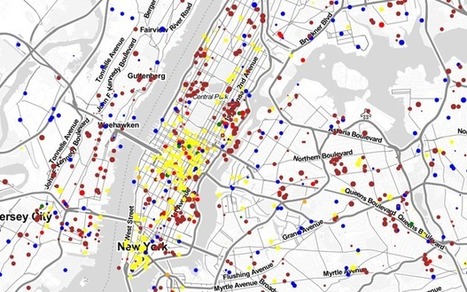
Watch the commuting patterns of New York, San Francisco and Los Angeles.
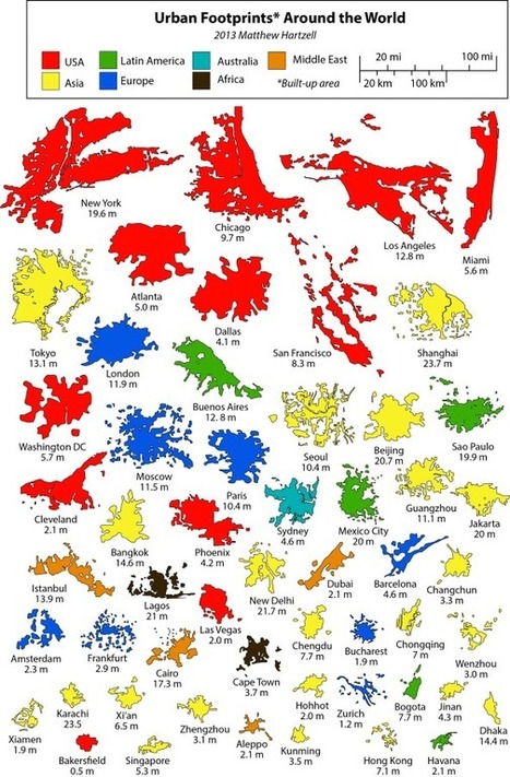
"This is a series of infographics (or geo-infographics) created by Matthew Hartzell, a friend of mine that I met when we were both geography graduate students at Penn State in few years back..."

Jacob Crowell's curator insight,
October 14, 2014 3:25 PM
This is an interesting way to graph out the urban footprints of various cities from around the world. This also shows how the United States has a number of the largest urban centers in the world. Along the top, New York, Chicago, LA, and Miami are massive compared to cities like Hong Kong. This shows how in the United States there are massive amounts of urban growth. Even in China where their population is one of the worlds biggest, Hong Kong a major city only has 7.1 million. In the United States, for the past century cities have been growing and this graph shows that. 
Samuel D'Amore's curator insight,
December 14, 2014 6:40 PM
These visuals really help to show that the size of a city doesn't necessarily correspond with it's population. Many years ago the trend was the larger the city in turn it would posses a larger population than a physically smaller city. Today this no longer holds true, in fact many smaller cities vastly out populate large sprawling cities. Most of these mega-cities in Asia and Latin America are incredibly over build and densely packed surrounded by miles of slums.
The Town Square Initiative is a yearlong volunteer effort in which Gensler designers set out to unearth and re-imagine unexpected open space in cities around the globe. All 43 Gensler offices were invited to participate in the conceptual project, in which we challenged our designers to identify open space in the city and reimagine it as a town square.
Visit the link for more images, diagrams and information on Gensler New York’s design of their future city. Via Lauren Moss
The urban ecology framework of Patch Dynamics has been key in watching how city models such as the megalopolis and the megacity interact and generate urban ecosystem change.
Urban Design practices have always been created in response to emerging and overlapping city models and the disciplinary contexts designers find themselves in. The urban ecology framework of Patch Dynamics has been key in allowing me to see how city models such as the megalopolis and the megacity interact and generate urban ecosystem change. One's first thought about a patch may be that of a shape that changes. However, the concept of a patch in this case describes a set of patches or a mosaic that changes over time. This search is not to find or create the best patch mosaics, or those that function in the most resilient ways. Instead, it is a project of creating urban design practices and strategies for a diversity of urban actors to engage their patches and democratize the resilience cycle in their own ways. Via Lauren Moss
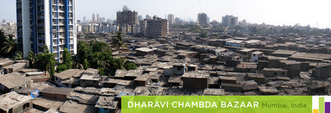
The capital of the South Asian country Bangladesh, Dhaka, has a population that is booming. However, it stands as one of the world's poorest mega-cities. This report comes from a GlobalPost series about the rise of mega-cities. Via geofoodgraz

Jess Deady's curator insight,
May 4, 2014 8:50 PM
To be a megacity like this, you have to conform to urbanization. There is no possible way to have such a populated and crowed city with farmlands around. This is a place of business yet residential areas, it also is where the marketplaces are and where kids go to school. Megacities need to be a part of an urban society in order for them to stay afloat. 
Bec Seeto's curator insight,
October 30, 2014 6:07 PM
This is a great introduction to the demographic explosion of the slums within megacities. This is applicable to many themes within geography. 
Sarah Cannon's curator insight,
December 14, 2015 10:20 AM
I can't image or even relate to the experience of living in a place like this. With rivers polluted right outside your house. And those rivers are what people bathe in and wash their clothes. I can't imagine not being able to access clean drinking water or lacking food. The people in Dhaka endure so much their whole lives, a good percentage of them will always live in poverty.

Imran Ahmed Khan's comment,
January 17, 2013 3:44 PM
Good picture! It defines the growth of the city that impact on urbanization rate, public health, socioeconomic environment. It also tell us that if we reduce vehicles on the road more space and clean environment may we get, that reduce motality and morbadity of several disease especially lung diseases.

Lauren Jacquez's curator insight,
April 8, 2013 9:31 PM
What are the benefits for each? Drawbacks? You decide!

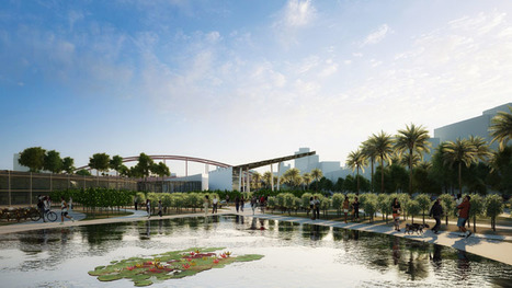
China's next new city will be designed by US firm KPF, next to Hunan's regional capital, around a 40-hectare lake.
Adjacent to Changsha, the ancient capital city of Hunan, the design implements the sort of urban innovation that creates a sustainable and truly habitable environment. "We can introduce integrated urban innovation," von Klemperer says, "we can combine water transport with localised energy production, cluster neighbourhood centres, advanced flood prevention and water management, and urban agriculture. Meixi is an experiment in future city planning and building. It will serve Changsha as a new CBD, but it will also serve as a paradigm for other Chinese city planners. It's a kind of live test case."
The firm seeks to achieve these goals through its dense, mixed-use urban, plan, with integration with surrounding mountains, lakes, parks and canals. Meixi Lake will eventually be home to 180,000 inhabitants, living in "villages" of 10,000 people, clustered around the canals...
Via Lauren Moss
association concert urbain's insight:
via @Territori
It's time to start seriously planning for climate change in the city.
New York City didn’t have to flood quite this badly, or, at least, it doesn’t have to again. There's no shortage of ideas out there for how the city could adapt to rising sea levels (or, we’ll just say it: climate change). A lot of them haven’t been deployed or more seriously studied because they seem too expensive or daunting.
But an event like Sandy quickly changes that calculus. Suddenly, some of these solutions don’t look quite as expensive as cleaning up after a hurricane... Via Lauren Moss

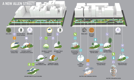
The phrase “the other side of the tracks,” connoting declining neighborhoods across from railroad lines, could easily translate to the community havoc wreaked by urban interstates. Noise, pollution, and walls of concrete can be more than a little off-putting. But new projects in cities around the world prove that freeways don’t necessarily have to be urban dead zones. In places like San Francisco and Oakland, where earthquakes led to the replacement of several freeway stretches, interstates have been redesigned and upgraded into walkable, pleasant spaces. Other innovative approaches are showing how to transform the right-of-way land, overpasses, and adjacent spaces to be visually attractive assets--and even raise property values as businesses and residents move closer and begin to look at their infrastructure more favorably. In Seattle, Freeway Park includes space on both sides of I-5 and a green-covered pedestrian overpass connecting them, giving a convention center easy access to a large parking structure across the freeway. Shanghai’s dramatic light-sculpture installation on its freeway placed the road in a new visual context for residents, and dozens of examples have followed. Melbourne used art panels and artful sound barriers to enable development to move closer to the freeway. Houston’s Buffalo Bayou Park, located underneath an interstate, attracts thousands of annual visitors to festivals and events and is facilitating adjacent property-enhancement by private owners. Via Lauren Moss
The Density Atlas is a planning, design and development resource for comparing urban densities around the world. The Atlas features a unique metrics and scale system for a comprehensive understanding of urban density. Via Ignacio López Busón
|