


Follow, research and publish the best content
Get Started for FREE
Sign up with Facebook Sign up with X
I don't have a Facebook or a X account
Already have an account: Login

URBANmedias
76.1K views |
+1 today
 Your new post is loading...
 Your new post is loading...
Your new post is loading...
![[ #Geography & #Geospatial_technologies] Envisioning the Spatial University | URBANmedias | Scoop.it](https://img.scoop.it/I9DuYRrAGpWSx0v7vxKhmjl72eJkfbmt4t8yenImKBVvK0kTmF0xjctABnaLJIm9)
If geospatial technology helped us understand the costs, would we make different decisions about the value of electric reliability?
This is an excellent article that shows this as an important moment for geography. Geospatial technologies have been official listed as a growth sector in the economy: where will the workforce gain these skills? This is the perfect time to put geographic analysis together more firmly into the curriculum with the STEM disciplines so that spatial thinking throughout the curriculum. Geospatial technologies such as GIS are a are a common space where geography and STEM discipline can meet. 

The National Geographic Education team has produced a fabulous site that has online GIS tools for understanding the environment of the Cheasapeake Bay watershed. Students can upload their data, click on various layers, and use drawing and measuring tools. Other "Fieldscope" projects are available as well at: http://education.nationalgeographic.com/education/program/fieldscope/
|
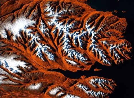
Of all the cosmic bodies studied in the long history of astronomy and space travel, the one that got the least attention was the one that ought to matter most to us—Earth. That changed when NASA created the Landsat program, a series of satellites that would perpetually orbit our planet, looking not out but down. Landsat was built for public monitoring of how the human species was altering the surface of the planet. The space agency, along with the U.S. Geological Survey (USGS), has accumulated a stunning catalog of images that, when riffled through and stitched together, create a high-definition slide show of our rapidly changing Earth, which for the first time date all the way back to 1984.
These Timelapse pictures tell the pretty and not-so-pretty story of a finite planet and how its residents are treating it — razing even as we build, destroying even as we preserve. Visit the article link to see an exclusive timelapse of climate change, deforestation and urban sprawl unfolding as Earth evolves over 30 years... Via Lauren Moss

Ishola Adebayo's comment,
July 31, 2013 9:07 AM
good day Sir, pls need help on fixing scan line errors on lansat7 ETM images from 2003 using for example ArcMap9.3 or ENVI4.5 or.........thank you so much

Courtney Barrowman's curator insight,
May 27, 2015 10:55 AM
summer work KQ2 key concepts: remote sensing, deforestation, desertification, land use, geospatial
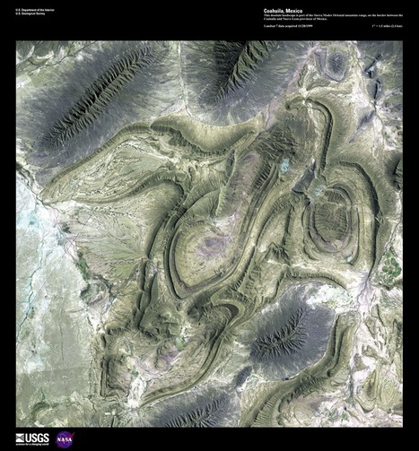
The USGS is celebrating 40 years of the LANDSAT Program by having a competition to select the top 5 "Earth as Art" images from the more than 120 scenes from their curated collection. All readers can select 5 images on the USGS website and the poll closes on July 6, 2012 (The image above is from Coahuila, Mexico).
|


This would be great to teach the power of tornadoes for Science!
En cas de catatrophe naturelle, les sociétés d'imagerie satellitaire mettent à la disposition du public leurs images. Ici deux images sont superposées et un volet permet de constater l'étendue des dégâts. A remarquer le fait que la tornade suit une trajectoire précise épargnant certains lieux tout proches.