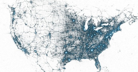
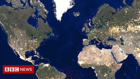
Ever wonder what it would look like to plot every single geotagged tweet since 2009 on a map? Twitter has done just that.
Get Started for FREE
Sign up with Facebook Sign up with X
I don't have a Facebook or a X account


|
Scooped by
Geography Teachers' Association of Victoria Inc. (GTAV)
onto GTAV Technology and cartography in Geography October 15, 2013 6:02 AM
|
Ever wonder what it would look like to plot every single geotagged tweet since 2009 on a map? Twitter has done just that.


 Your new post is loading...
 Your new post is loading...
Your new post is loading...
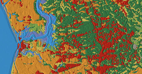
Dynamic World is a 10 meter resolution near real time global land use land cover dataset in Google Earth Engine
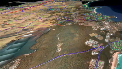
In a world-first, Tasmania will be recreated in a real-time virtual model to help predict where disasters will happen and how to keep communities safer.
Geography Teachers' Association of Victoria Inc. (GTAV)'s insight:
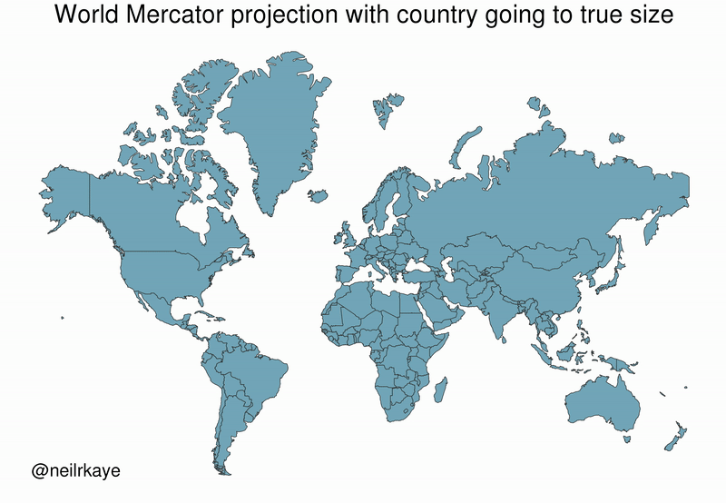
Visual Capitalist - real size of countries.

From
www

A new website lets people delve into data on the world's cities.
Geography Teachers' Association of Victoria Inc. (GTAV)'s insight:
Excellent data on lots of cities

There are 510 million km² of area on the Earth, but less than 30% of this is land. Here's the share countries make up of the Earth's surface.
Excellent study of project 2030 to map to unknown areas of the sea floor
Geography Teachers' Association of Victoria Inc. (GTAV)'s insight:
Mapping the sea floor is fascinating for Level 7 Water - link to the finding of the underwater drone off Indoiesia in December 2020
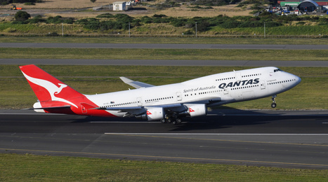
Qantas has bid adieu to its final Boeing 747-400 today. But in true Qantas style, the plane isn’t…
Geography Teachers' Association of Victoria Inc. (GTAV)'s insight:
This was cute, sad and GPS!
Scientists have discovered the magnetic field is gradually weakening in an area spanning several continents.
Geography Teachers' Association of Victoria Inc. (GTAV)'s insight:
fascinating - what is happening the the magnetic pole and why? and what impacts is it having?
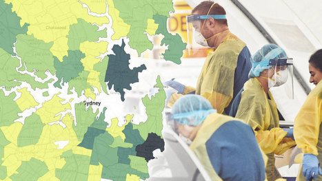
New heat maps will for the first time reveal active coronavirus cases by postcode, revealing how many people have the virus, test numbers and recovery rates.
Geography Teachers' Association of Victoria Inc. (GTAV)'s insight:
A good example of Australian mapping during coronavirus
GIS can help researchers analyze spatial data within social media posts in order to understand how people react to different features in their environment.
Geography Teachers' Association of Victoria Inc. (GTAV)'s insight:
Attitudes have as much geographical validity as statistics...

Esri Australia’s GIS for schools program provides a platform for students to understand GIS technology and gain skills that can be applied in the real world.
Geography Teachers' Association of Victoria Inc. (GTAV)'s insight:
Such a valuable, in fact essential, tool for all students. And so many jobs in the future in this area...
Ways and approaches to teach about ethics in Geographic Information Systems and related geotechnology courses. Maps are laden with ethical decisions--and need to be used and created with care and respect. Watch this video to find out more.
Geography Teachers' Association of Victoria Inc. (GTAV)'s insight:
Accurate information is often the basis of ethics. Technology can easily allow ethical approaches to be overridden. Joseph Kerski explores this.

Photogrammetry uses photographs from at least two different vantage points. It obtains depth and perspective because of separate points of observation.
Geography Teachers' Association of Victoria Inc. (GTAV)'s insight:
Fascinating article on photogrammetry explaining the process and uses - good for STEM and students with a technical bent
|
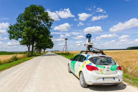
Digital mapping tools like Google Street View often obscure the realities of cities and concentrate their resources in the wealthiest countries, effectively ‘erasing’ some places from the global map.
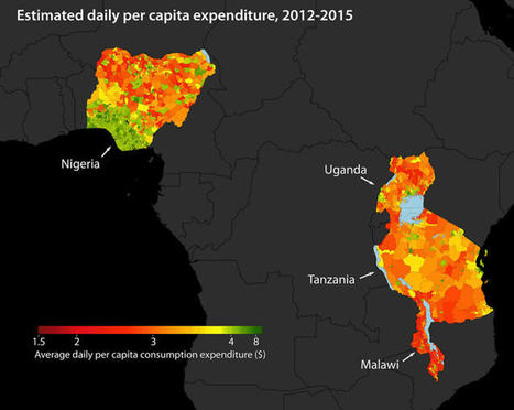
Satellite images are now being used to map poverty levels around the world using machine learning used to analyze specific poverty data using a convolutional neural network.
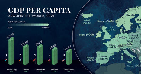
GDP per capita is one of the best measures of a country's standard of living. This map showcases the GDP per capita in every country globally.
Earth's poles are moving — and that's normal. But new research suggests that within just decades, climate change and human water use have given the poles' wandering an additional nudge.

Ideas for teachers on how to use spatial technologies in the classroom.
Geography Teachers' Association of Victoria Inc. (GTAV)'s insight:
Queensland but really useful ideas
New, interactive GPlates Portal globe showcases the world's surface geology. Beautiful and educational!
Geography Teachers' Association of Victoria Inc. (GTAV)'s insight:
Making Geology maps accessible and fascinating
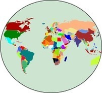
Create your own free custom World map with colors and descriptions of your choice. Download it for free and use it for a great visual representation.
Geography Teachers' Association of Victoria Inc. (GTAV)'s insight:
This is brilliant - get it! so useful
One measure of how much Melburnians adore our town and its quirky details, even when we can't get among it, is that a cult item to own right now is the puzzle of an illustrated map.
Geography Teachers' Association of Victoria Inc. (GTAV)'s insight:
The Melbourne Map is brilliant - one of these for your school would be great

This detailed and incredible map shows the exact date of origin for every one of the world's international borders.
Geography Teachers' Association of Victoria Inc. (GTAV)'s insight:
Fascinating and intruiging
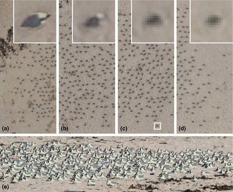
Remote sensing data from satellite and UAV imagery has been used by researchers in the mapping and observation of wildlife, in particular counting the number of animals in remote locations.
Geography Teachers' Association of Victoria Inc. (GTAV)'s insight:
Effectiuve and efficient agricultural methods
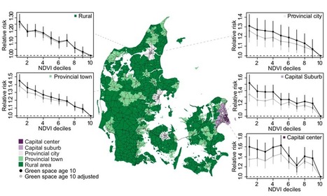
A recent large-scale study in Denmark combined historical Landsat satellite data and a survey that recorded mental health benefits to respondents to analyze the relationship between green space and mental health.
Geography Teachers' Association of Victoria Inc. (GTAV)'s insight:
This is so obvious...but now it is proven with GIS
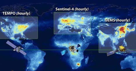
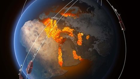
NASA, South Korea, and the European Space Agency are collaborating on a project to monitor air pollution from space. It will allow scientists to measure pollution every hour from space for the first time.
Geography Teachers' Association of Victoria Inc. (GTAV)'s insight:
Satellite technology used to monitor and help manage air pollution.
|