Climate change, urban renewal, typhoons, land redistribution: enjoy this selection of material brought to you courtesy of the Rondebosch Boys' High School Library (If you would like to receive a weekly newsletter of the latest items in this Scoop just mail me at library@rondebosch.com)
In this episode of Eye on Gauteng we look at urban renewal and the case currently being made by the residents and business owners of the Maboneng Precinct in down town Jo’burg.
The Eye on Gauteng team visits the area to hear the stories of those that live, work and play there. We also find out more about doing business in Joburg’s inner city.
Medellin is a city that has achieved a lot in the last 20 years. It has transcended its difficult past and become a better integrated, more accessible and safer place to live than before. It is no longer the ‘no-go’ city for Colombians, tourists and businesses that it once was.
Today Medellin is a bustling, cosmopolitan city with a good transport system that is clean, efficient and integrated. The city’s public spaces are well-used, accessible and contribute to uplifting the areas in which they have been developed. Citizens enjoy greater access – via the city’s integrated transit routes – to neighbouring communities, libraries, schools and other public facilities like community parks and educational institutions than previously.
Neighbourhoods, particularly in the city’s poorer areas, are safer than they were before.
Mahala profiles Greenpop, a Cape Town business with an embedded social cause.
Poloko lives on the outskirts of Joburg with his grandmother and two younger sisters. At twenty years young, he’s seen first-hand all the ills of kasi life eMzansi. Up until last year, he had been attending the local high school where puffing the odd zol by the river nearby took pole position on his daily schedule. After getting lifted, he would slip back into the hood to check on his girlfriend who, at the time, was six months pregnant with their child.
The pressure of having a baby on the way with no gainful employment, amplified by taking care of his siblings and feeling trapped inside a public education system which persistently fails to contribute meaningfully to its students’ knowledge base, led to him seeking out an alternative. That old dirty crime story. The details are sketchy; he makes the odd comment about a near-prison stint, but evades my questions which attempt to prod further. We’re at a corner café in Braamfontein; what was supposed to be short banter has turned into full conversation as we wait for our orders – a kota for him, slap-chips for me. He gets uneasy when I mention jail, so we just skip the line of questions about the crimes he’s committed.
Geoneutrinos paint picture of deep-mantle processes.
A window on the deep Earth opened unexpectedly in 2011, when Japan’s nuclear reactors were shut down after the Fukushima disaster. Before the closure, an underground particle detector called KamLAND based in Kamioka, Japan, was monitoring a torrent of neutrinos streaming from dozens of nearby nuclear reactors, seeking clues to the nature of these hard-to-catch subatomic particles. After those plants fell silent, KamLAND scientists could see more clearly a signal that had largely been obscured: a faint trickle of neutrinos produced inside the planet.
Neutrinos are generated in stars, reactors, and deep in Earth’s crust and mantle by the radioactive decay of elements such as uranium and thorium. KamLAND reported the first tentative detections of these ‘geoneutrinos’ in 2005 (ref. 1). But last month at a conference in Takayama, Japan, KamLAND scientists reported seeing them in meaningful quantities — as did a team at the Borexino neutrino detector at the Gran Sasso National Laboratory near L’Aquila, Italy.
Climate change has a disconcerting tendency to amplify itself through feedback effects. Melting sea ice exposes dark water, allowing the ocean to soak up more heat. Arctic warming speeds the release of carbon dioxide from permafrost. And, as researchers discussed at a meeting last week in Seefeld, Austria, climate extremes — heatwaves, droughts and storms — can hamper plant growth, weakening a major buffer against the rise of CO2 in the atmosphere.
“Heatwaves and droughts will very likely become more frequent in a warmer climate, and ecosystems will somehow respond,” says Philippe Ciais, a carbon-cycle researcher at the Laboratory of Climate and Environmental Sciences in Gif-sur-Yvette, France. “More storms will add an extra dimension to the problem.”
The March 11, 2011 earthquake and tsunami left more than 28,000 dead or missing. See incredible footage of the tsunami swamping cities and turning buildings into rubble.
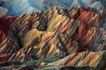
Long ago, colorful sediments were deposited in western China, layer after layer, century after century. If you were there at the time, you would have seen unremarkable ground, a single hue of dirt no different from a thousand other places on Earth.
But after thousands and thousands of years subject to the forces of pressure and tectonic movement, the total of those layers has been pushed upward, letting us peek at a rainbow-hued slice of Earth’s past perhaps unmatched on this planet. The planet looks more like the cross-section of a jawbreaker candy than layers of rock in these photos, near Zhangye, China.
The big news from Google today was the release of Street View imagery for Mount Everest, Mount Aconcagua, Mount Elbrus, and Mount Kilimanjaro. Those are four of what are referred to by mountaineers as the Seven Summits.
The imagery doesn't take you to the summit of Mount Everest but you can take a look around base camp and the approach to it. The imagery may spark your students' curiosity about Mount Everest and if it does you will want to take a look at the following resources.
DAYLIGHT filters through the ether in Africa’s tallest residential building, a brutalist cylindrical skyscraper with a hollow core that drops 54 floors to a ragged base of exposed bedrock. The view into the interior is eerie, a dim light giving it a sci-fi feel that recalls the film “Blade Runner”. But the outward-facing windows offer breathtakingly clear views, some of the best in Johannesburg, South Africa’s commercial capital.
Ponte City was a posh address when it opened in 1975 at the edge of what was then the trendy inner-city district of Hillbrow, during the race-segregated era when central Johannesburg boomed. Ambitious developers planned to add an indoor ski slope inside the building.
In South Africa, the phenomenon of gentrification is commonly associated with the resurrection of downtown Johannesburg and the rebirth of Woodstock in Cape Town. Both areas share a common denominator for gentrification: a growing middle class with disposable incomes and a taste for all things designer. And both fail to support government’s claim that it is creating inclusive cities for all, writes LAURA A WENZ. “When I first moved to New York, it was dingy, disgusting, dirty, ugly, flea-ridden, stinky and altogether terrifying – but then sadly the whole city started to go uphill,” laments Ted Mosby, the naïve and inveterately romantic protagonist of the popular American TV-comedy series How I met your Mother. His sentimental statement captures the glum irony of urban regeneration: Neighbourhoods with the right mix of historical flair, cosmopolitan ambience and urban decay perpetually attract students, young professionals and artists in search of cheap rent and inspiration.
Emma Hartley: Hadfield's photograph, taken from the International Space Station, showed a divide between the east and west of the German capital
The Berlin Wall may be physically disappearing – David Hasselhoff went there to campaign for its preservation last month – but some things last longer than mere bricks and mortar. Town planning, for instance, as Colonel Chris Hadfield demonstrated when he took this picture of Berlin from the International Space Station on Wednesday last week.
The Canadian astronaut has become a social media star thanks to his efforts to normalise space flight by telling us about his experiences through the medium. And what better way to engage humanity than by showing it pictures of itself and the planet on which it lives from his heroic perspective?
An ambitious plan to slash greenhouse-gas emissions must clear some high technical and economic hurdles.
In an industrial warehouse on the outskirts of Stuttgart, the sooty past is shaking hands with Germany's green-energy future. In one corner sits a relic destined for a museum: a cast-iron engine as big as a bus, which was used until the early 1970s to compress coal gas for lighting, cooking and heating. Nearby, a gleaming network of stainless-steel tanks uses electricity to create methane out of water and carbon dioxide.
This power-to-gas (P2G) pilot plant is the largest of its kind in the world, and the research behind it could help to propel Germany to the front of the race for cleaner energy. Developers of the €3.5-million (US$4.5-million) project say that the P2G technology is an ideal way to cope with the unreliable nature of solar and wind power. During sunny or breezy days, excess electricity can be used to make methane, which can be stored and then burned to generate power when the winds fail or the days turn dark.
The first Earth Day, in 1970, was inspired by anger. The nation was a mess. Four million gallons of oil from a blown offshore well were smearing California beaches. Flames leapt from the surface of Ohio’s Cuyahoga River. Bald eagles, our national symbol, had been winnowed by hunting and chemical pollution to a few hundred breeding pairs in the lower 48 states. It’s no wonder that 20 million people took to the streets.
Today that passion has morphed into guilt. Our lifestyles are driving global climate change, and developing countries want to grow and consume like wealthy nations. Earth Day has become a day for penance—picking up trash, turning off lights—and debating whether the environmental movement has lost its way.
Introspection is healthy within limits. And yes, saving the planet is more complicated now than it seemed 40 years ago. But analysis and what-ifs shouldn’t obscure a simple point: Without an environmental movement, the United States would be a lesser country. As Hemingway wrote in For Whom the Bell Tolls, “The world is a fine place and worth the fighting for.” Many people have lived out those words by saving beautiful spots that otherwise might be paved over, polluted, or flooded today. Here are seven examples to be thankful for, all open for visits year-round and prime destinations to enjoy on Earth Day.
It's fun to day dream while looking up at the clouds, but have you ever wondered how clouds are formed. Our science guy, Steve Spangler, shows us how to make our own cloud-maker using materials you can find in the garage.
Popular science educator Michael from Vsauce returns to the web to discuss gravity and the Sun. As a thought experiment, he asks the interesting hypothetical, “What if the sun disappeared?“
It’s not going to happen, but interestingly enough, if it did, we wouldn’t be aware that anything was wrong for a good eight minutes, as it takes that long for light to travel the millions of miles from the Sun to the Earth.
What’s surprising about Everest Base Camp is the color. It’s a flinty, gray place littered with shards of Himalayan sandstone and shale. Here and there appears a vivid green pool of alpine water. And then there’s the red, blue and green prayer flags hung by Himalayans to blow blessings in the wind.
Google Street View’s latest project, the World’s Highest Peaks, takes us to Everest and two other mountains included in the Seven Summits—the highest mountains on each of the seven continents.
Teams of mountaineers toted digital cameras on treks to the top of each mountain and integrated their images into Google maps so we can trek along with them from the comfort of our laptops, iPhones or Android devices. Like Google Street View’s Ocean gallery, the mountain images bring us to places we may never see with our own eyes.
Back in 1999, Penn State University climate scientist Michael Mann released the climate change movement's most potent symbol: The "hockey stick," a line graph of global temperature over the last 1,500 years that shows an unmistakable, massive uptick in the 20th century, when humans began to dump large amounts of greenhouse gases into the atmosphere. It's among the most compelling bits of proof out there that human beings are behind global warming, and as such has become a target on Mann's back for climate denialists looking to draw a bead on scientists.
To get content containing either thought or leadership enter:
To get content containing both thought and leadership enter:
To get content containing the expression thought leadership enter:
You can enter several keywords and you can refine them whenever you want. Our suggestion engine uses more signals but entering a few keywords here will rapidly give you great content to curate.


 Your new post is loading...


 Scoop.it!