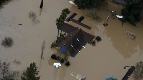
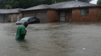
Torrential rains of nearly a half-foot in 24 hours across southern Brazil led to flooding that has killed at least 10 people.
Get Started for FREE
Sign up with Facebook Sign up with X
I don't have a Facebook or a X account


 Your new post is loading...
 Your new post is loading...
Your new post is loading...
Torrential rains of nearly a half-foot in 24 hours across southern Brazil led to flooding that has killed at least 10 people.
PIRatE Lab's insight:
Rains in Brazil have caused ten fatalities. The governor warns a larger and more destructive disaster is soon to come. Preparations and mitigations are being attempted to prevent any further losses.

No comment yet.
Sign up to comment
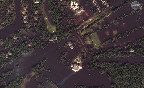
The Ohio River has crested in communities such a Pittsburgh and Marietta, Ohio, but is expected to continue to rise in Southwest Ohio, where Cincinnati is located. A water level gauge in downtown Cincinnati showed the river was expected to crest on Monday at 52.3’.
PIRatE Lab's insight:
The Ohio river has flooded many parts in West Virginia and Ohio as the water crests over the riverbanks. It is reported that "...this is the highest [the river] has been in decades." An emergency declaration has been established in several counties along the river. The NOAA river gauge has reported a peak height of 44.71 feet as of Apr 05, 2024.
From
www

The Mississippi rose to 22.7 feet in Davenport, Iowa last week.
From
www
The only way to access the towns, which are under mandatory evacuation, is by boat.
Before and after images of flooding in North Carolina from Hurricane Florence.

The Senate on Tuesday voted to renew the National Flood Insurance Program hours before it was set to expire during the height of hurricane season. The
Local, State, Federal Officials Say Major Progress Made In Cleanup Of Debris From Thomas Fire, Flood
From
kclu
Local, state, and federal officials say there’s been significant progress made in debris removal efforts connected with the Thomas Fire, and flood. At a
From
abc7
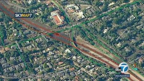
Amid ongoing search-and-rescue and cleanup operations in Montecito, a satellite view from AIR7 HD shows the destruction wrought by flooding and mudslides in the area.
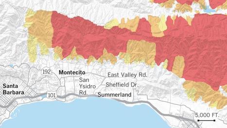
These maps show how Montecito has been hit by fires, rainfall, mudslides and debris flows.
Marketplace® is your liaison between economics and life. Noted for timely, relevant and accessible coverage of business news across both audio and digital platforms, Marketplace programs are heard by more than 14 million weekly listeners. This makes the Marketplace portfolio the most widely heard business or economic programming in the country.
Hundreds of thousands of people live in flood-prone cities like Houston, Miami, New Orleans, Tampa Bay and New York. Here’s what 500-year floods look like, or could look like, in those cities.
PIRatE Lab's insight:
Great graphic illustrating "500 year" flood events.
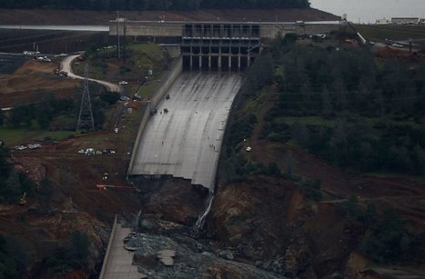
Oroville dam spillway failure was caused by design defects that left it too weak to control rushing storm water this year.
|
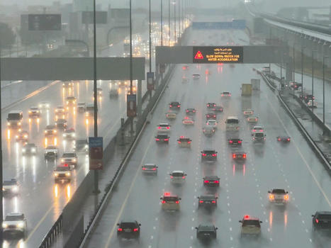
Rescue teams search for two missing people in Oman as bad weather disrupts travel in the United Arab Emirates.
PIRatE Lab's insight:
Heavy rains and severe flash flooding have been reported in parts of Oman and the UAE. Major highway systems have been closed as floodwaters partially submerge vehicles.

Autum Baird's comment,
April 19, 2024 11:45 PM
This is astonishing. Nine schoolchildren and their driver were lost because of the significant flooding, which washed away their vehicle. Every driver should be tested on what to do when roads flood. Deaths can be avoided when people shelter in place or evacuate to higher ground.

The first of two storm systems is drenching the West Coast, triggering rock slides and flooding roads. Via Anonymous Hades

David N. Folino's comment,
February 6, 7:07 PM
This love hate relationship we Californians have with rain is frustrating at times like this.

Liano Becerra's comment,
February 7, 5:28 PM
Devastating to see people stuck in their vehicles. Great that we are receiving rain and snow but it's difficult to deal with when areas are being flooded.
A controversial dam will swell the Tigris River until its waters submerge the ancient city of Hasankeyf, forcing longtime residents to flee and swallowing up cultural treasures.
PIRatE Lab's insight:
I spent my last sabbatical trying to stop a dam in Turkey. It worked (for now), but many other dams have gone forward. The rampant destruction of biodiversity and culture for the sake of geopolitical positioning is sick. This is what is wrought when science and democracy is removed from governance.

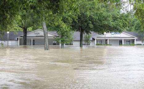
Record flooding in parts of the Midwest in March caused immense damage to agriculture. Water is still standing in fields where failed river levees have not yet been repaired. For some farmers and ranchers, already facing low commodity prices, tariffs and taxes, it’s a compounded level of stress driving record numbers to seek professional help. Nebraska PBS station NET's Jack Williams reports.
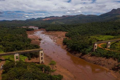
Day and night, rescue workers wade and crawl through the iron ore sludge, which is up to 24 feet deep in places.
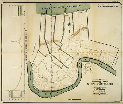
This month marks a year since the Aug. 5, 2017 flash flood and subsequent investigations in New Orleans.
Ellicott City was devastated by floodwaters Sunday, just two years after another storm ravaged the historic Howard County site.

The U.S. Army Corps of Engineers soon will hand over permanent pumping stations at the mouths of New Orleans' three primary drainage canals. The temporary pumps, which were beset with corrosion for years, will go offline.

Montecito Fire seven-person team including Maeve Juarez, Daniel Arnold and Robert Galbraith saved many people during early hours of mudflow disaster
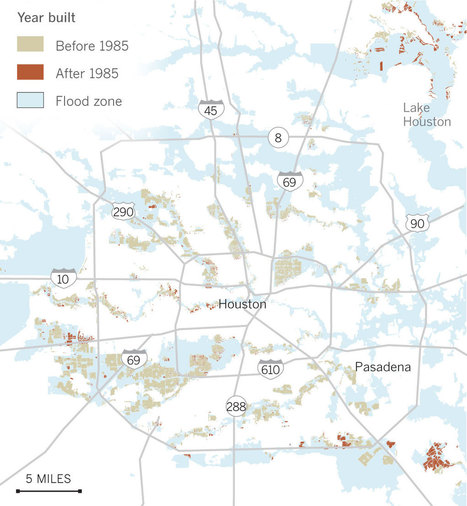
Beavers take advantage of ponds brimming with water, nearby dirt roads show little evidence of being recently inundated. In the greater Houston area, though, the staggering increase of impervious surfaces - roads, sidewalks, parking lots, anything covered with asphalt and concrete - has exacerbated the effects of flooding as development in the region has exploded. Things are further complicated in flat-as-a-pancake Houston, where much of the soil is heavily compacted and acts like pavement anyway, sending sheets of stormwater to the nearest low-lying area. A recent analysis of federal satellite data by the Houston Advanced Research Council for the Houston Chronicle shows that 337,000 acres of 1.1 million acres in Harris County were covered by impervious surfaces in 2011, the most recent year of data. That kind of development comes with a price, namely the loss of the region's natural landscape, including wetlands, prairies, coastal marshlands and forests, and thereby a greater risk of flooding. While many Houston-area homeowners blame inadequate stormwater mitigation rules for their flooding woes, city and county officials deny that but concede that it's difficult to untangle the effects of new development, flood control projects and climate change when trying to determine the culprit for the region's worsening flood problem. People love water features, said Trey Reichert, vice president and general manager of Riverstone for Johnson Development Corp. There's something very calming. Larry Dunbar was a consultant hired by Fort Bend in the early 80's to help draft the first set of detention pond requirements. [...] most counties were solely relying on drainage systems to combat runoff. The group, Residents Against Flooding, cited the 2007 widening of Bunker Hill Road north of I-10 and the elevation of nearby commercial properties, among other projects, alleging they funneled water into surrounding neighborhoods. The residents' group claims the defendants promised to build five detention ponds to alleviate flooding but only came through with one. A Texas A&M University study in 2011 found that clustered high-density development - the kind you see in the concrete-laden urban core of Houston - typically experience less in flood damages than sprawling low-density developments that have become hallmarks of Houston's suburbs. The 232 unit-complex, subsidized for low-income residents, was built in the floodway of Green's Bayou and is being rebuilt in the same spot in the city's Greenspoint neighborhood in north Houston near Bush Intercontinental Airport. Given the challenges associated with detention ponds and other structural solutions to Houston's regional flooding problems, officials are getting pressure to consider "greener" solutions. The Bayou Land Conservancy, which protects more than 2,000 acres in Montgomery County, wants to make sure development stays out of the floodplain and turn that land into a community amenity, whether a butterfly garden, wildlife habitat or a place for recreation. Stephanie Prosser, the conservancy's interim executive director, points to the Spring Creek Greenway, a forested corridor that spans the divide between Harris and Montgomery counties, as a good example of an environmentally friendly project. A study conducted by the Harris County Flood Control District two years ago looked at how water flows from the Cypress Creek watershed to Addicks and Barker reservoirs and shows that sage grass - grass with a similar root structure of the prairie grass found in that area - does a pretty good job of absorbing water given the poor absorption of the area's clay soil. In Pattison, smack dab in the middle of the Katy Prairie, more than 23 inches of rain fell during a 14-hour period on April 17 and 18, the highest amount ever recorded in the county for an historic rainfall event. [...] they'll need new roads to get there.

Here's a deep look at where major flooding events have occurred in the U.S. since 1985
PIRatE Lab's insight:
The patterns we have seen over recent decades is exactly what our general climate models suggest. Can you see the pattern here? Even with now-incorrect labels of flood frequency (based on old rainfall conditions from decades ago) this is still a great illustration of flooding extent AND the power of small, repetitive graphs to illustration change over time.
|