 Your new post is loading...

|
Scooped by
David Connolly
February 9, 2013 2:53 AM
|
A new book just published reveals the true extent of the Roman Empire’s attempts to conquer Scotland - and explores the archaeological legacy left behind. Written by Dr Rebecca Jones, an RCAHMS archaeologist and expert on the Roman frontiers, Roman Camps in Scotland brings together a full archaeological record of the Empire’s military outposts, which were designed to be the temporary homes for conquering legions and armies. Scotland is home to the largest number of surviving Roman camps in Europe, indicating that the attempts to conquer and occupy the land were much more extensive than previously thought. The new book highlights the sheer number of Roman camps throughout Scotland and the rest of the UK: up to 260 have been discovered and recorded in Scotland, adding to some 240 in England and Wales. The camps provided accommodation at the most basic level for soldiers. Although they were only occupied for very short periods of time, they have left distinctive imprints in the landscape that can still be detected today. Many camps are discovered through aerial survey flights, where the outlines of ancient structures lying beneath the soil show up as crop marks. The RCAHMS aerial survey collection and existing archives of camp excavations were used extensively by Dr Jones in her research. Now every new, known, and possible camp has been mapped and recorded, alongside details of its historical significance and role in the Roman campaigns in Scotland. Dr Jones said, “For the first time we have a picture of the true extent of the Roman war machine in Scotland. By mapping and recording the hundreds of temporary army outposts, we have provided an important benchmark for further research into the northernmost frontier of the Roman Empire.” The book is one of two new publications by Dr Jones. The second, Roman Camps in Britain, provides an overview of the Roman military operation throughout the whole of the UK. Roman Camps in Scotland is published by the Society of Antiquaries of Scotland, and Roman Camps in Britain is published by Amberley. You can also browse imagery and information on the Roman camps in Scotland on our online database Canmore. A new book just published reveals the true extent of the Roman Empire’s attempts to conquer Scotland - and explores the archaeological legacy left behind. Written by Dr Rebecca Jones, an RCAHMS archaeologist and expert on the Roman frontiers, Roman Camps in Scotland brings together a full archaeological record of the Empire’s military outposts, which were designed to be the temporary homes for conquering legions and armies. Scotland is home to the largest number of surviving Roman camps in Europe, indicating that the attempts to conquer and occupy the land were much more extensive than previously thought. The new book highlights the sheer number of Roman camps throughout Scotland and the rest of the UK: up to 260 have been discovered and recorded in Scotland, adding to some 240 in England and Wales. The camps provided accommodation at the most basic level for soldiers. Although they were only occupied for very short periods of time, they have left distinctive imprints in the landscape that can still be detected today. Many camps are discovered through aerial survey flights, where the outlines of ancient structures lying beneath the soil show up as crop marks. The RCAHMS aerial survey collection and existing archives of camp excavations were used extensively by Dr Jones in her research. Now every new, known, and possible camp has been mapped and recorded, alongside details of its historical significance and role in the Roman campaigns in Scotland. Dr Jones said, “For the first time we have a picture of the true extent of the Roman war machine in Scotland. By mapping and recording the hundreds of temporary army outposts, we have provided an important benchmark for further research into the northernmost frontier of the Roman Empire.” The book is one of two new publications by Dr Jones. The second, Roman Camps in Britain, provides an overview of the Roman military operation throughout the whole of the UK. Roman Camps in Scotland is published by the Society of Antiquaries of Scotland, and Roman Camps in Britain is published by Amberley. You can also browse imagery and information on the Roman camps in Scotland on our online database Canmore.
|
|
Scooped by
David Connolly
February 5, 2013 2:25 AM
|
Cylindrical objects made usually of fired clay but sometimes of stone were found at the Yarmukian Pottery Neolithic sites of Sha‘ar HaGolan and Munhata (first half of the 8th millennium BP) in the Jordan Valley. Similar objects have been reported from other Near Eastern Pottery Neolithic sites. Most scholars have interpreted them as cultic objects in the shape of phalli, while others have referred to them in more general terms as “clay pestles,” “clay rods,” and “cylindrical clay objects.” Re-examination of these artifacts leads us to present a new interpretation of their function and to suggest a reconstruction of their technology and mode of use. We suggest that these objects were components of fire drills and consider them the earliest evidence of a complex technology of fire ignition, which incorporates the cylindrical objects in the role of matches. Citation: Goren-Inbar N, Freikman M, Garfinkel Y, Goring-Morris NA, Grosman L (2012) The Earliest Matches. PLoS ONE 7(8): e42213. doi:10.1371/journal.pone.0042213
|
|
Scooped by
David Connolly
January 28, 2013 9:07 AM
|
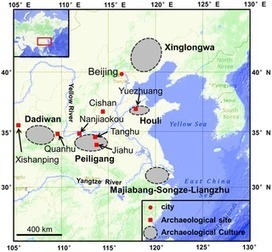
The Peiligang Culture (9000-7000 cal. yr BP) in the Middle Yellow River region, North China, has long been considered representative of millet farming. It is still unclear, however, if broomcorn millet or foxtail millet was the first species domesticated during the Peiligang Culture. Furthermore, it is also unknown whether millet was cultivated singly or together with rice at the same period. In this study, phytolith analysis of samples from the Tanghu archaeological site reveals early crop information in the Middle Yellow River region, China. Our results show that broomcorn millet was the early dry farming species in the Peiligang Culture at 7800 cal. yr BP, while rice cultivation took place from 7800 to 4500 cal. yr BP. Our data provide new evidence of broomcorn millet and rice mixed farming at 7800 cal. yr BP in the Middle Yellow River region, which has implications for understanding the domestication process of the two crops, and the formation and continuance of the Ancient Yellow River Civilization. Citation: Zhang J, Lu H, Gu W, Wu N, Zhou K, et al. (2012) Early Mixed Farming of Millet and Rice 7800 Years Ago in the Middle Yellow River Region, China. PLoS ONE 7(12): e52146. doi:10.1371/journal.pone.0052146
|
|
Scooped by
David Connolly
January 22, 2013 2:02 AM
|
The construction of large dams — and consequently the creation of extensive reservoirs — has obvious implications for the archaeological heritage and requires rapid archaeological intervention within the salvage projects set up in mitigation. This is the case of the Ilisu Dam, which will affect the Upper Tigris region in a few years. The time allowed to excavate the sites in the construction area (Ökse et al. 2008) is even more limited, requiring us to carry out the investigations very rapidly. As a result, we have developed a way of recording structures, using innovative methods of photogrammetry, to document quickly the plan and profiles of a single-storied building complex at the Iron Age settlement site of Zeviya Tivilki (Ökse et al. 2010). The complex consists of foundations of rough stones set directly on the bedrock.
|
|
Scooped by
David Connolly
January 11, 2013 2:55 AM
|
For most of human history on this planet—about 90 per cent of the time—sea levels have been substantially lower than at present, exposing large tracts of territory for human settlement. Europe alone would have had a land area increased by 40 per cent at the maximum sea level regression (Figure 1). Although this has been recognised for many decades, archaeologists have resisted embracing its full implications, barely accepting that most evidence of Palaeolithic marine exploitation must by definition be invisible, believing that nothing has survived or can be found on the seabed, and preferring instead to emphasise the opportunities afforded by lower sea level for improved terrestrial dispersal across land bridges and narrowed sea channels. In the past decade, opinions have begun to change in response to a number of factors: evidence that marine exploitation and seafaring have a much deeper history in the Pleistocene than previously recognised; the steady accumulation of new underwater Stone Age sites and materials, amounting now to over 3000 in Europe, and often with unusual and spectacular conditions of preservation (Figure 2); availability of new technologies and research strategies for underwater exploration; and the growth of targeted underwater research (Erlandson 2001; Bailey & Milner 2002; Anderson et al. 2010; Benjamin et al. 2011).
|
|
Scooped by
David Connolly
January 4, 2013 4:16 AM
|
The European Neolithization ~6000−4000 BC represents a pivotal change in human history when farming spread and the mobile style of life of the hunter-foragers was superseded by the agrarian culture. Permanent settlement structures and agricultural production systems required fundamental innovations in technology, subsistence, and resource utilization. Motivation, course, and timing of this transformation, however, remain debatable. Here we present annually resolved and absolutely dated dendroarchaeological information from four wooden water wells of the early Neolithic period that were excavated in Eastern Germany. A total of 151 oak timbers preserved in a waterlogged environment were dated between 5469 and 5098 BC and reveal unexpectedly refined carpentry skills. The recently discovered water wells enable for the first time a detailed insight into the earliest wood architecture and display the technological capabilities of humans ~7000 years ago. The timbered well constructions made of old oak trees feature an unopened tree-ring archive from which annually resolved and absolutely dated environmental data can be culled. Our results question the principle of continuous evolutionary development in prehistoric technology, and contradict the common belief that metal was necessary for complex timber constructions. Early Neolithic craftsmanship now suggests that the first farmers were also the first carpenters. Citation: Tegel W, Elburg R, Hakelberg D, Stäuble H, Büntgen U (2012) Early Neolithic Water Wells Reveal the World's Oldest Wood Architecture. PLoS ONE 7(12): e51374. doi:10.1371/journal.pone.0051374
|
|
Scooped by
David Connolly
December 29, 2012 5:27 PM
|
A 213-year oak tree-ring chronology has been constructed from timbers from several sites from first-millennium AD Constantinople, in particular, from the study of over 2000 samples from harbour installations at Yenikapı, Istanbul (Pekin & Kangal 2007). A tentative dendrochronological placement of the 213-year sequence against other tree-ring series suggests an absolute date range of AD 398–610 for the time-series (Pearson et al. submitted). We report a radiocarbon dating project to provide an independent near-absolute chronological placement for this important chronology.
|
|
Scooped by
David Connolly
December 24, 2012 3:00 AM
|
The disappearance of Neanderthals in Europe and in the northern regions of the Mediterranean basin is a debated topic in which the archaeological record plays a leading role in the development of models focused on the settlement dynamics of indigenous populations. In the last decades the investigation of markers that could shed light on the possible interactions between Neanderthals and Anatomically Modern Humans are again at the centre of attention, for chronometric refinements (Higham et al.2009; Higham 2011) as well as for the re-examination of some human remains (Benazzi et al. 2011). In large areas of the Northern Adriatic region, the latest Middle Palaeolithic is undocumented. Only in the Veneto region and ephemerally along the Dalmatian coast do archaeological sites show that the remarkable ecological diversity between the alluvial plains and the Prealps was exploited, with some key cave sites showing evidence of intense and repeated occupation. Within this context, sites are characterised by short-term use associated with neighbouring flint outcrops or used as logistical stops along seasonal routes.
|
|
Scooped by
David Connolly
December 18, 2012 5:01 PM
|
Building upon previous implementations of an on-site digital archaeology system for field recording (Levy & Smith 2007; Levy et al. 2010; Petrovic et al. 2011; Gidding et al. in press), a real-time 3D data recording interface called ArchField has been developed for a total reconstruction of architecture and recovered material culture (Figure 1). Since 1998, the methodological goal of our fieldwork has been to develop a streamlined fully integrated Geographic Information System (GIS) that would enable the production of digital top plans and at the end of the season publication-quality digital maps, charts and tables. By using GIS as the nexus for data storage and analysis, our research has played a major role in the application of digital/cyber-archaeology field methods to help answer historical, anthropological and archaeological questions. These goals have led to the innovation of a new on-site digital archaeology recording system for field recording and digital conservation called ArchField.
|
|
Scooped by
David Connolly
December 11, 2012 1:56 AM
|
Journal of Raman Spectroscopy, 2012, 43, 1523–1844
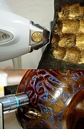
Danilo Bersani et al. The Sixth edition of the International Congress on the Application of Raman Spectroscopy in Art and Archeology (RAA 2011) was held in Parma (Italy) from 5 to 8 September 2011, following the tradition of biennial conferences started in London (2001). The previous congresses were held in Ghent (2003), Paris (2005), Modena (2007)and Bilbao (2009). As in the previous congresses, the scientific program was focused on the analysis by means of Raman spectroscopy of materials related to cultural heritage and archaeology (pigments, dyes, inks, paper, polymers, glass, ceramics, resins, fibers, corrosion products) including topics related to natural heritage (gemstones, minerals, fossils) and some aspects involving forensic science. In this edition, particular attention was put on the new techniques (CARS, SERS, resonance) and on the recent developments in Raman data interpretation (chemometrics, simulation of Raman spectra, imaging and mapping). The editorial and two further papers are free to view
|
|
Scooped by
David Connolly
December 9, 2012 3:05 AM
|
You can find this out for a house you are interested in buying or just interested in for any reason at all. You don't have to live in a house or a property to be curious about it.
|
|
Rescooped by
David Connolly
from LiveLatin
December 5, 2012 4:41 PM
|
|
|
Scooped by
David Connolly
December 4, 2012 8:53 AM
|
Presently celebrating the 200th anniversary of its re-identification by Johann Ludwig Burckhardt in 1812, the ancient city of Petra is experiencing a surge in interest. In the landscape surrounding this famed World Heritage site, however, there is a wealth of archaeological potential that spans over 1 million years—including occupation by three hominin species (Homo erectus, Homo neanderthalensis and Homo sapiens sapiens)—to more recent historical settlements. This short article introduces an Early Bronze Age site north of Petra, discovered by a Brown University project designed to document the entire range of occupation in the Petra region.
|
|
|
Scooped by
David Connolly
February 8, 2013 11:50 AM
|
Do you enjoy a dark steaming cup of coffee or a light warm mug? Kurt Hunt, aka the Sexy Archaeologist, examines the color of coffee using a Munsell chart.
|
|
Scooped by
David Connolly
January 28, 2013 9:57 AM
|
|
|
Scooped by
David Connolly
January 25, 2013 2:19 AM
|
An international team comprised of experts in diving and underwater archaeology from Sri Lanka, India, Indonesia, Malaysia and the Philippines participated in the assessment of a shipwreck at Godawaya, Sri Lanka.
|
|
Scooped by
David Connolly
January 11, 2013 12:03 PM
|
The Tomb of the Shroud is a first-century C.E. tomb discovered in Akeldama, Jerusalem, Israel that had been illegally entered and looted. The investigation of this tomb by an interdisciplinary team of researchers began in 2000. More than twenty stone ossuaries for collecting human bones were found, along with textiles from a burial shroud, hair and skeletal remains. The research presented here focuses on genetic analysis of the bioarchaeological remains from the tomb using mitochondrial DNA to examine familial relationships of the individuals within the tomb and molecular screening for the presence of disease. There are three mitochondrial haplotypes shared between a number of the remains analyzed suggesting a possible family tomb. There were two pathogens genetically detected within the collection of osteological samples, these were Mycobacterium tuberculosis and Mycobacterium leprae. The Tomb of the Shroud is one of very few examples of a preserved shrouded human burial and the only example of a plaster sealed loculus with remains genetically confirmed to have belonged to a shrouded male individual that suffered from tuberculosis and leprosy dating to the first-century C.E. This is the earliest case of leprosy with a confirmed date in which M. leprae DNA was detected.
|
|
Scooped by
David Connolly
January 7, 2013 2:22 AM
|
Imagine having to write about a rock. A simple thing really? Well, no, you aren’t allowed to see the rock. All you are allowed to do is witness the splash and ripples in the pond after the rock’s been thrown in. From the size of the splash, the noise and the resulting ripples you can guess what the rock might look like in terms of size and dimensions. But it’s not the same as holding that rock in your hand. This is an apt metaphor for trying to work out the Etruscans, they were hugely influential and their ripples pulse through Roman culture yet so much of what we’d normally use to define and understand them is absent. We don’t have any Etruscan plays or writings, we rely instead on the reports of others. It’s a delicious mystery.
|
|
Scooped by
David Connolly
January 2, 2013 3:45 PM
|
The province of Dalmatia was divided into three juridical districts (conventi iuridici): Scardona, Salona and Narona, of which the first was organized on the basis of the territorial principle and encompassed a higher number of municipalities... The provincial imperial cult was organized in the territories of Hispania Citerior (Tarraconensis), south-west Germania and Illyricum, thus in those provinces in which major wartime gains and conquests were achieved precisely by the cult’s founders, Gaius Julius Caesar and Octavian Augustus. Of the three districts (conventi) recorded in the province of Dalmatia, the archaeological remains indicate official worship of a regional imperial cult within the Scardona conventus, and probably within the Salona conventus as well. According to epigraphic material that mentions ara Augusti Liburnorum, sacerdos Liburnorum and civitates Liburniae, the cult was organized only for the Liburnian community. Archaeological evidence from the territory of Narona speaks of organized imperial worship already during the lifetime of Augustus, although they all indicate the cult’s municipal level. During the era of the Flavian dynasty, the regional imperial cult in Scardona was revived, while a new regional imperial cult was established for the communities of south-east Dalmatia in Doclea.
|
|
Scooped by
David Connolly
December 27, 2012 3:36 AM
|
Space competition effects are well-known in many microbiological and ecological systems. Here the authors analyze such an effect in human populations. The Neolithic transition (change from foraging to farming) was mainly the outcome of a demographic process that spread gradually throughout Europe from the Near East. In Northern Europe, archaeological data show a slowdown on the Neolithic rate of spread that can be related to a high indigenous (Mesolithic) population density hindering the advance as a result of the space competition between the two populations. By measuring this slowdown from a database of 902 Early Neolithic sites and develop a time-delayed reaction-diffusion model with space competition between Neolithic and Mesolithic populations, to predict the observed speeds. The comparison of the predicted speed with the observations and with a previous non-delayed model show that both effects, the time delay effect due to the generation lag and the space competition between populations, are crucial in order to understand the observations.
|
|
Scooped by
David Connolly
December 21, 2012 7:10 AM
|
|
|
Scooped by
David Connolly
December 13, 2012 2:11 AM
|
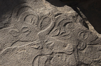
The Messak Project started in summer 2010 as a joint project of the Libyan Department of Archaeology and the Italian-Libyan Archaeological Mission in the Acacus and Messak of Sapienza University of Rome, a three-year programme of heritage research and management of the Messak plateaux in south-western Libya. At the end of February 2011, in the final stages of the first season, the civil uprising interrupted the research and determined the termination of the project. After eight months of conflict, there is growing concern from the international scientific community about the state of the Libyan cultural heritage and its role in the future of the country ( http://whc.unesco.org/en/news/799/). In this respect, we believe that communication of the preliminary results of the project can contribute to keep focusing attention on the Libyan situation, and to emphasise the wealth and outstanding value of the cultural heritage in a remote but crucial area for the country.
|
|
Scooped by
David Connolly
December 10, 2012 2:51 AM
|
Kazeroun County is located in Fars province in Iran at an altitude of 732m asl (Figure 1). The plain of Kazeroun and Lake Parishan sit between two mountain ranges oriented north-west to south-east (Mozaffarian 1994: 25). The majority of studies in this area have been conducted by western archaeologists on historical sites (in particular of the Sassanid period) such as the city of Bishapour and at Tange Chogan, Sar Mashad and Tange Ghandil. The objective of this survey was to locate and identify prehistoric sites in the area under study; more broadly to study settlement patterns, population fluctuations over time, the relationship between sites and the environment and finally to identify important central places. To survey the Kazeroun plain, satellite maps and a topographic map at a scale of 1:50 000 were first prepared, and the plain divided into four parts: north, south, east and west. The survey itself was conducted from south to north and the sampling method was random. For each site, a Kazeroun Survey number (SK number) was assigned. The data gathered included GPS position, site dimensions, local topography, information regarding place names or historical background, and factors such as vegetation, climate and landscape.
|
|
Scooped by
David Connolly
December 7, 2012 3:39 AM
|
Interest in the processes by which human populations expanded from a presumed centre of origin in Africa to colonise the rest of the world has never been higher, thanks to new fossil, archaeological, palaeoclimatic and genetic data. Strong attention currently focuses on the Arabian Peninsula, and the proposal, stimulated by palaeogenetic interpretations, that Anatomically Modern Humans originating in East Africa dispersed rapidly across the southern end of the Red Sea and the Arabian Peninsula about 60 000 years ago, fuelled by new adaptations involving reliance on marine foods and seafaring, and culminating in the colonisation of New Guinea and Australia (Walter et al. 2000; Macaulay et al. 2005; Mellars 2006).
|
|
Scooped by
David Connolly
December 5, 2012 12:57 PM
|
Although world-renowned as an archaeological site, there have been few research projects in Pompeii looking at the spatial and chronological patterning of plant food use from an archaeobotanical perspective. The recent 12 years of archaeological excavations (1995–2006) by the Anglo-American Project in Pompeii have provided a rare opportunity to investigate a whole city block (Regione VI, Insula 1). This included a blanket sampling strategy of all contexts where archaeobotanical macro-remains, both carbonised and calcium phosphate replaced material, have been recovered, the results from which are reported here.
|


17 December 2011