Your new post is loading...

|
Scooped by
Dr. Stefan Gruenwald
February 9, 2017 6:12 PM
|
Wish you had another hour in the day to get everything done? Just wait 200 million years, when days here on Earth will stretch to 25 hours. While we like to think of the Earth’s rotation as one of the few constants in this world, it’s anything but. For hundreds of millions of years, days have been growing longer and longer. The changes are small enough that our circadian clocks can’t detect them, but atomic clocks certainly can. According to the National Institute of Standards and Technology, which runs the United States’ atomic clocks, days today are longer than those a century ago by two milliseconds. Add that up over millions of years and you start to see real changes—days in the Jurassic period were only 23 hours long, for example.
|
|
Scooped by
Dr. Stefan Gruenwald
January 29, 2017 1:28 PM
|
Climate simulations show how changes in Earth’s orbit alter the distribution of sea ice on the planet, helping to set the pace for the glacial cycle. Earth is currently in what climatologists call an interglacial period, a warm pulse between long, cold ice ages when glaciers dominate our planet’s higher latitudes. For the past million years, these glacial-interglacial cycles have repeated roughly on a 100,000-year cycle. Now a team of Brown University researchers has a new explanation for that timing and why the cycle was different before a million years ago. Using a set of computer simulations, the researchers show that two periodic variations in Earth’s orbit combine on a 100,000-year cycle to cause an expansion of sea ice in the Southern Hemisphere. Compared to open ocean waters, that ice reflects more of the sun’s rays back into space, substantially reducing the amount of solar energy the planet absorbs. As a result, global temperature cools. “The 100,000-year pace of glacial-interglacial periods has been difficult to explain,” said Jung-Eun Lee, an assistant professor in Brown’s Department of Earth, Environmental and Planetary Studies and the study’s lead author. “What we were able to show is the importance of sea ice in the Southern Hemisphere along with orbital forcings in setting the pace for the glacial-interglacial cycle.”
|
|
Scooped by
Dr. Stefan Gruenwald
January 17, 2017 12:19 AM
|
Scientists have found that 55 million years ago the Arctic was once a lot like Miami, with an average temperature of 74 degrees Fahrenheit, alligator ancestors and palm trees, scientists say. That conclusion, based on first-of-their-kind core samples extracted from more than 1,000 feet below the Arctic Ocean floor, is contained in three studies published in Thursday's issue of the journal Nature.
Scientists say the findings are both a glimpse backward at a region heated by naturally produced greenhouse gases run amok and a sneak peek at what manmade global warming could do someday.
Scientists believe a simple fern may have been responsible for cooling things back down by sucking up massive amounts of the carbon dioxide responsible for the warming. But this natural solution to global warming wasn't exactly quick: It took about a million years.
The Earth went through an extended period of natural global warming, capped off by a supercharged spike of carbon dioxide that accelerated the greenhouse effect even more about 55 million years ago. Scientists already knew this "thermal event" happened, but figured that while the rest of the world got really hot, the polar regions were still comfortably cooler, maybe about 52 degrees on average.
But the new research from the multinational Arctic Coring Expedition found the polar average was closer to 74. "It's the first time we've looked at the Arctic, and man, it was a big surprise to us," said study co-author Kathryn Moran, an oceanographer at the University of Rhode Island. "It's a new look to how the Earth can respond to these peaks in carbon dioxide."
The 74-degree temperature — based on core samples, which act as a climatic time capsule — was probably the year-round average. But because the data is so limited, it could also be simply the summertime average, researchers said.
"Imagine a world where there are dense sequoia trees and cypress trees like in Florida that ring the Arctic Ocean," said Yale geology professor Mark Pagani, a study co-author. He said it was probably a tropical paradise, "but the mosquitoes were probably the size of your head."
Researchers are not sure what caused the sudden boost of carbon dioxide that set the greenhouse effect on broil. Possible culprits could be huge releases of methane from the ocean, gigantic continent-sized burning of trees, or lots of volcanic eruptions.
|
|
Scooped by
Dr. Stefan Gruenwald
December 14, 2016 1:56 PM
|
Aerosols could cool the planet without ozone damage | To halt the rise of global temperatures, Harvard researchers are looking at solar geoengineering, which would inject light-reflecting sulfate aerosols into the stratosphere to cool the planet. The planet is warming at an unprecedented rate, and reducing emissions of greenhouse gases alone is not enough to remove the risk. Last year’s historic Paris climate agreement set the goal of keeping global temperatures no higher than 1.5 degrees Celsius above preindustrial levels. Emission reductions will be central to achieving that goal, but supplemental efforts can further reduce risks. One drastic idea is solar geoengineering — injecting light-reflecting sulfate aerosols into the stratosphere to cool the planet. Researchers know that large amounts of aerosols can significantly cool the planet; the effect has been observed after large volcanic eruptions. But these sulfate aerosols also carry significant risks. The biggest known risk is that they produce sulfuric acid in the stratosphere, which damages ozone. Since the ozone layer absorbs ultraviolet light from the sun, its depletion can lead to increased rates of skin cancer, eye damage, and other adverse consequences. Now, researchers from the Harvard John A. Paulson School of Engineering and Applied Sciences (SEAS) have identified an aerosol for solar geoengineering that may be able to cool the planet while simultaneously repairing ozone damage. The research is published in the Proceedings of the National Academy of Sciences. “In solar geoengineering research, introducing sulfuric acid into the atmosphere has been the only idea that had any serious traction until now,” said David Keith, the Gordon McKay Professor of Applied Physics at SEAS and professor of public policy at the Harvard Kennedy School, the first author of the paper. “This research is a turning point and an important step in analyzing and reducing certain risks of solar geoengineering.”
|
|
Scooped by
Dr. Stefan Gruenwald
December 8, 2016 5:18 PM
|
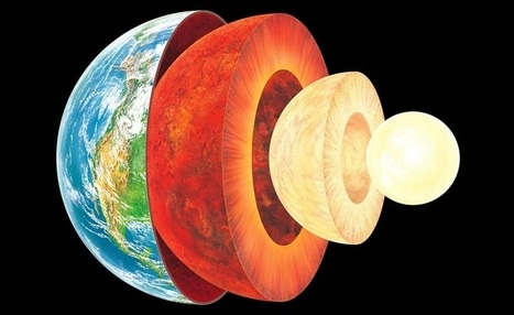
Einstein’s general theory of relativity predicts the center of the Earth is two years younger than the crust. Our home planet is young at heart. According to new calculations, Earth’s center is more than two years younger than its surface. In Einstein’s general theory of relativity, massive objects warp the fabric of spacetime, creating a gravitational pull and slowing time nearby. So a clock placed at Earth’s center will tick ever-so-slightly slower than a clock at its surface. Such time shifts are determined by the gravitational potential, a measure of the amount of work it would take to move an object from one place to another. Since climbing up from Earth’s center would be a struggle against gravity, clocks down deep would run slow relative to surface time pieces. Over the 4.5 billion years of Earth’s history, the gradual shaving off of fractions of a second adds up to a core that’s 2.5 years younger than the planet’s crust, researchers estimate in the May European Journal of Physics. Theoretical physicist Richard Feynman had suggested in the 1960s that the core was younger, but only by a few days.
|
|
Scooped by
Dr. Stefan Gruenwald
November 28, 2016 1:02 PM
|
These white mounds are the world’s largest gypsum dune field, centerpiece of the White Sands National Monument. The white hills sprawling in every direction look like mounds built by snow plows, or massive hills of sugar. In fact, they’re the world’s largest gypsum dune field: the White Sands National Monument, located in southern New Mexico. During the last Ice Age, melting snow and ice from the San Andres Mountains (west of the dunes) and the Sacramento Mountains (to the east) eroded minerals from the hillsides and carried them downhill to the basin below. Lake Otero formed on the spot. As the climate warmed and the water evaporated, the basin remained full of selenite (the crystalline form of gypsum) and created the Alkali Flats. Over time, winds broke the crystals into sand grains, which built up into the dunes visible in this mosaic of photographs taken by an astronaut from the International Space Station on June 20, 2016. Today, that geological process continues. Gypsum-rich mountain waters flow down into the basin below, where the hot desert sun dries the water and winds break up newly formed selenite crystals. At the south end of the monument, occasional rains cause water to accumulate in Lake Lucero before evaporating. Because the basin has no outlet, gypsum here accumulates instead of getting pushed downstream and dissolving.
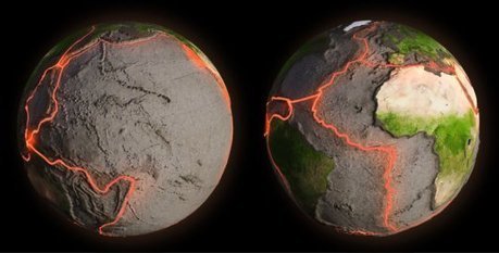
A 35-mile rift in the desert of Ethiopia will likely become a new ocean eventually, researchers now confirm. The crack, 20 feet wide in spots, opened in 2005 and some geologists believed then that it would spawn a new ocean. But that view was controversial, and the rift had not been well studied. A new study involving an international team of scientists and reported in the journal Geophysical Research Letters finds the processes creating the rift are nearly identical to what goes on at the bottom of oceans, further indication a sea is in the region's future. The same rift activity is slowly parting the Red Sea, too. Using newly gathered seismic data from 2005, researchers reconstructed the event to show the rift tore open along its entire 35-mile length in just days. Dabbahu, a volcano at the northern end of the rift, erupted first, then magma pushed up through the middle of the rift area and began "unzipping" the rift in both directions, the researchers explained in a statement today. "We know that seafloor ridges are created by a similar intrusion of magma into a rift, but we never knew that a huge length of the ridge could break open at once like this," said Cindy Ebinger, professor of earth and environmental sciences at the University of Rochester and co-author of the study. The result shows that highly active volcanic boundaries along the edges of tectonic ocean plates may suddenly break apart in large sections, instead of in bits, as the leading theory held. And such sudden large-scale events on land pose a much more serious hazard to populations living near the rift than would several smaller events, Ebinger said. "The whole point of this study is to learn whether what is happening in Ethiopia is like what is happening at the bottom of the ocean where it's almost impossible for us to go," says Ebinger. "We knew that if we could establish that, then Ethiopia would essentially be a unique and superb ocean-ridge laboratory for us. Because of the unprecedented cross-border collaboration behind this research, we now know that the answer is yes, it is analogous."
Via Kathy Bosiak
|
|
Scooped by
Dr. Stefan Gruenwald
November 3, 2016 1:45 PM
|
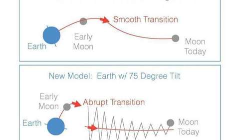
Earth's Moon is an unusual object in our solar system, and now there's a new theory to explain how it got where it is, which puts some twists on the current "giant impact" theory. The work is published Oct. 31 in the journal Nature. The Moon is relatively big compared to the planet it orbits, and it's made of almost the same stuff, minus some more volatile compounds that evaporated long ago. That makes it distinct from every other major object in the Solar System, said Sarah Stewart, professor of Earth and planetary sciences at the University of California, Davis and senior author on the paper. The textbook theory of lunar formation goes like this. Late in the formation of the solar system came the "giant impact" phase, when hot planet-size objects collided with each other. A Mars-sized object grazed what would become Earth, throwing off a mass of material from which the Moon condensed. This impact set the angular momentum for the Earth-Moon system, and gave the early Earth a five-hour day. Over millennia, the Moon has receded from the Earth and the rotation has slowed to our current 24-hour day. Scientists have figured this out by looking at the Moon's current orbit, working out how rapidly angular momentum of the Earth-Moon system has been transferred by the tidal forces between the two bodies, and working backwards. But there are a couple of problems with the textbook theory. One is the Moon's surprisingly Earth-like composition. Another is that if the Moon condensed from a disk of material rotating around Earth's equator, it should be in orbit over the equator. But the Moon's current orbit is tilted off the equator, meaning some more energy must have been put in to move it. Stewart, her former postdoctoral fellow Matija Ćuk (now a scientist at the SETI Institute in Mountain View, Calif.), with Douglas Hamilton at the University of Maryland and Simon Lock, Harvard University, have come up with an alternative model. In the new model, a high energy collision left a mass of vaporized and molten material from which the Earth and Moon formed. The Earth was set spinning with a two-hour day, its axis pointing towards the Sun. Because the collision could have been more energetic than in the current theory, the material from Earth and the impactor would have mixed together, and both Earth and Moon condensed from the same material and therefore have a similar composition. As angular momentum was dissipated through tidal forces, the Moon receded from the Earth until it reached a point called the "LaPlace plane transition," where the forces from the Earth on the Moon became less important than gravitational forces from the Sun. This caused some of the angular momentum of the Earth-Moon system to transfer to the Earth-Sun system. This made no major difference to the Earth's orbit around the Sun, but it did flip Earth upright. At this point, the models built by the team show the Moon orbiting Earth at a high angle, or inclination, to the equator. Over a few tens of million years, the Moon continued to slowly move away from Earth until it reached a second transition point, the Cassini transition, at which point the inclination of the Moon—the angle between the Moon's orbit and the Earth's orbit about the sun—dropped to about five degrees, putting the Moon more or less in its current orbit.
|
|
Scooped by
Dr. Stefan Gruenwald
October 13, 2016 12:54 AM
|
New data has confirmed that the Earth has been experiencing the hottest temperatures on record. The latest findings from NASA’s top climate scientists now reveal the world is heating up at a rate that hasn’t occurred within the past 1,000 years. According to NASA, the planet will continue to warm “at least” 20 times faster than the historical average over the next 100 years. Gavin Schmidt, director of Nasa’s Goddard Institute for Space Studies, said that “in the last 30 years we’ve really moved into exceptional territory.” He added, “It’s unprecedented in 1,000 years. There’s no period that has the trend seen in the 20th century in terms of the inclination (of temperatures).” July 2016 was the hottest month on record, and this year the average global temperature peaked at 1.38˚C above levels reported in the 19th century. That number is dangerously close to the 1.5C limit determined by the Paris Climate Agreement. Nasa warns that temperatures will only increase by leaps and bounds at the rate we are going. If we have even the slimmest of hopes to combat this unprecedented rate of global warming, Schmidt says, “maintaining temperatures below the 1.5˚C guardrail requires significant and very rapid cuts in carbon dioxide emissions or co-ordinated geo-engineering. That is very unlikely. We are not even yet making emissions cuts commensurate with keeping warming below 2˚C.” “It’s the long-term trend we have to worry about though and there’s no evidence it’s going away and lots of reasons to think it’s here to stay,” Schmidt said. “There’s no pause or hiatus in temperature increase. People who think this is over are viewing the world through rose-tinted spectacles. This is a chronic problem for society for the next 100 years.”
|
|
Scooped by
Dr. Stefan Gruenwald
September 20, 2016 12:57 PM
|
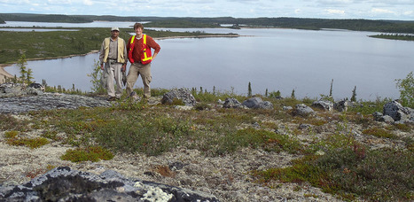
Addressing fundamental unknowns about the earliest history of Earth’s crust, scientists have precisely dated the world’s oldest rock unit at 4.02 billion years old. Driven by the University of Alberta, the findings suggest that early Earth was largely covered with an oceanic crust-like surface. “It gives us important information about how the early continents formed,” says lead author Jesse Reimink. “Because it’s so far back in time, we have to grasp at every piece of evidence we can. We have very few data points with which to evaluate what was happening on Earth at this time.” In fact, only three locations worldwide exist with rocks or minerals older than 4 billion years old: one from Northern Quebec, mineral grains from Western Australia, and the rock formation from Canada’s Northwest Territories examined in this new study. While it is well known that the oldest rocks formed prior to 4 billion years ago, the unique twist on Reimink’s rock is the presence of well-preserved grains of the mineral zircon, leaving no doubt about the date it formed. The sample in question was found during fieldwork by Reimink’s PhD supervisor, Tom Chacko, professor in the Department of Earth and Atmosphere Sciences, in an area roughly 300 kilometres north of Yellowknife. Reimink recently completed his PhD at the University of Alberta before starting a post-doctoral fellowship at the Carnegie Institute for Science in Washington, D.C. “Zircons lock in not only the age but also other geochemical information that we’ve exploited in this paper,” Reimink continues. “Rocks and zircon together give us much more information than either on their own. Zircon retains its chemical signature and records age information that doesn’t get reset by later geological events, while the rock itself records chemical information that the zircon grains don’t.” He explains that the chemistry of the rock itself looks like rocks that are forming today in modern Iceland, which is transitional between oceanic and continental crust. In fact, Iceland has been hypothesized as an analog for how continental crusts started to form.
|
|
Scooped by
Dr. Stefan Gruenwald
September 19, 2016 3:03 PM
|
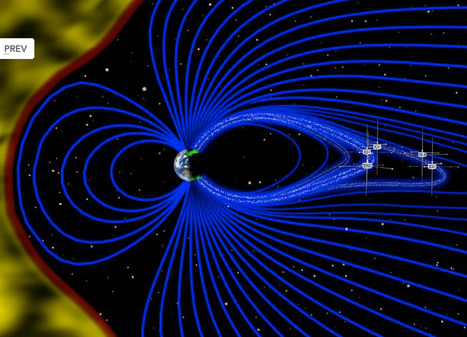
The majestic auroras have captivated humans for thousands of years, but their nature -- the fact that the lights are electromagnetic and respond to solar activity -- was only realized in the last 150 years. Thanks to coordinated multi-satellite observations and a worldwide network of magnetic sensors and cameras, close study of auroras has become possible over recent decades. Yet, auroras continue to mystify, dancing far above the ground to some, thus far, undetected rhythm. Using data from NASA's Time History of Events and Macroscale Interactions during Substorms, or THEMIS, scientists have observed Earth's vibrating magnetic field in relation to the northern lights dancing in the night sky over Canada. THEMIS is a five-spacecraft mission dedicated to understanding the processes behind auroras, which erupt across the sky in response to changes in Earth's magnetic environment, called the magnetosphere. These new observations allowed scientists to directly link specific intense disturbances in the magnetosphere to the magnetic response on the ground. A paper on these findings was published in Nature Physics on Sept. 12, 2016. "We've made similar observations before, but only in one place at a time - on the ground or in space," said David Sibeck, THEMIS project scientist at NASA's Goddard Space Flight Center in Greenbelt, Maryland, who did not participate in the study. "When you have the measurements in both places, you can relate the two things together." Understanding how and why auroras occur helps us learn more about the complex space environment around our planet. Radiation and energy in near-Earth space can have a variety of effects on our satellites - from disrupting their electronics to increasing frictional drag and interrupting communication or navigation signals. As our dependence on GPS grows and space exploration expands, accurate space weather forecasting becomes ever more important. The space environment of our entire solar system, both near Earth and far beyond Pluto, is determined by the sun's activity, which cycles and fluctuates through time. The solar system is filled with solar wind, the constant flow of charged particles from the sun. Most of the solar wind is deflected from Earth by our planet's protective magnetosphere.
|
|
Scooped by
Dr. Stefan Gruenwald
August 29, 2016 12:19 AM
|
Continents cruise in the slow lane. Moving just millimeters at a time, it took the ancient supercontinent Pangea hundreds of millions of years to break apart into today’s landmasses. But a study published Tuesday shows that the journey wasn’t always a leisurely drive. When under extreme strain, the tectonic plates hit the throttle and accelerated to speeds 20 times faster than they were traveling before. “It’s the equivalent of moving around as a pedestrian to moving around in a very fast BMW,” said Dietmar Muller, a geophysicist at the University of Sydney and an author of the paper, which appeared in Nature. “While the continental crust was still being stretched, all of a sudden there was this amazing acceleration, and we didn’t know why.” After analyzing seismic data from across the world and building a model, Dr. Muller and his team discovered that plates move in two distinct phases: a slow phase and a fast one. During the slow phase, the continental crusts, which can be more than 20 miles thick, are stretched out little by little while remaining connected. But then suddenly, one or both of the continents step on the gas pedal. “A critical point is reached when the connection between the two continents becomes so weak it can no longer resist the forces trying to pull it apart,” Dr. Müller said. “This acceleration is directly related to the thinning of the crust.” Using a computer simulation they illustrated the points in geologic history when pairs of land masses shifted speeds as they drifted apart. This is most dramatically seen between North America and Africa during Pangea’s initial rift some 240 million years ago.
|
|
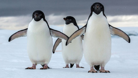
Scooped by
Dr. Stefan Gruenwald
June 30, 2016 6:46 PM
|
A new study finds significant impact, and a possible silver lining, for the iconic birds over the next century. Adélie penguins (Pygoscelis adeliae) have survived in Antarctica for nearly 45,000 years, adapting to glacial expansions and sea ice fluctuations driven by millennia of climatic changes. The penguins remained resilient through these changes, but new research from the University of Delaware suggests that unique 21st-century climates may pose an existential threat to many of the colonies on the Antarctic continent. Published Wednesday in Scientific Reports, the study, led by oceanographer Megan Cimino, found that up to 60 percent of the current Adélie penguin habitat in Antarctica could be unfit to host colonies by the end of the century. The Adélie penguin is one of two true Antarctic penguins—the other being the emperor penguin (Aptenodytes forsteri)—and it inhabits the full extent of the continent. The penguins nest on land during the austral (southern) summer, and migrate during the winter to the edge of the sea ice, where they are able to feed at sea. Using a combination of field survey data and high-resolution satellite imagery, the researchers were able to stitch together 30 years of colony data, from 1981 to 2010, at sites ringing Antarctica. Looking at the year-to-year data, the researchers were able to identify population trends at each colony site for the full 30-year period. The scientists found diverging trends at different sites. Some colonies, like the closely monitored population near Palmer Station, a United States research hub in northern Antarctica, saw declines of over 80 percent.
|
|
|
Scooped by
Dr. Stefan Gruenwald
February 8, 2017 1:43 PM
|
Three new minerals discovered by a Michigan Tech alumnus are secondary crusts found in old uranium mines. They're bright, yellow and hard to find. The mines closed four decades ago, but that doesn’t stop air and water from traveling the long tunnels of Red Canyon. The old opening at the mine—the adit—cuts straight into the hill and has helped make new minerals. The adit opens to a dry panorama in southern Utah. "Have you ever seen The Hills Have Eyes? It's that kind of creepy, barren desert landscape," says Travis Olds '12 and now a graduate student at Notre Dame studying uranyl mineral compounds. He adds that he and others find mineralogy so exciting because of "the idea that there are things we still don't know—and someone can see a pretty crystal and appreciate it." Olds specifically studies uranyl minerals because, as radioactive materials, it is important to know where they are found and how they change in different environments. Within the past year, he found three new uranium minerals in Red Canyon: leesite, leószilárdite and redcanyonite.
|
|
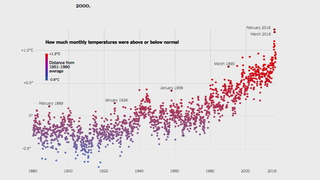
Rescooped by
Dr. Stefan Gruenwald
from Nostri Orbis
January 20, 2017 3:29 PM
|
Global temperatures have continued to rise, making 2016 the hottest year on the historical record and the third consecutive record-breaking year, scientists say. Of the 17 hottest years ever recorded, 16 have now occurred since 2000.
Via Fernando Gil
|
|
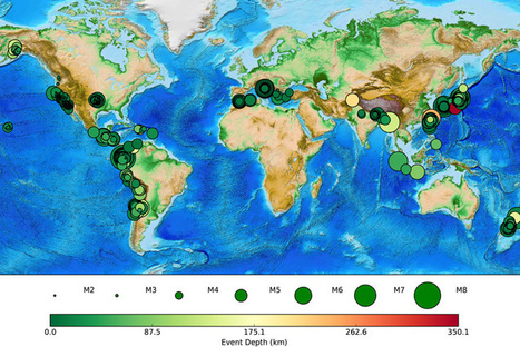
Scooped by
Dr. Stefan Gruenwald
December 15, 2016 11:38 PM
|
The Android app harnesses a smartphone’s motion detectors to measure earthquake ground motion, then sends that data back to the Berkeley Seismological Laboratory for analysis. The eventual goal is to send early-warning alerts to users a bit farther from ground zero, giving them seconds to a minute of warning that the ground will start shaking. That’s enough time to take cover or switch off equipment that might be damaged in a quake. To date, nearly 220,000 people have downloaded the app, and at any one time, between 8,000 and 10,000 phones are active — turned on, lying on a horizontal surface and connected to a wi-fi network — and thus primed to respond. An updated version of the MyShake app will be available for download today (Dec. 14) from the Google Play Store, providing an option for push notifications of recent quakes within a distance determined by the user, and the option of turning the app off until the phone is plugged in, which could extend the life of a single charge in older phones. “The notifications will not be fast initially — not fast enough for early warning — but it puts into place the technology to deliver the alerts and we can then work toward making them faster and faster as we improve our real-time detection system within MyShake,” said project leader Richard Allen, a UC Berkeley professor of earth and planetary sciences and director of the seismology lab. In a presentation today, during this week’s annual meeting of the American Geophysical Union in San Francisco, UC Berkeley developer and graduate student Qingkai Kong will summarize the app’s performance. Ten months of operation clearly shows that the sensitivity of the smartphone accelerometers and the density of phones in many places are sufficient to provide data quickly enough for early warning. The phones readily detect the first seismic waves to arrive — the less destructive P waves — and send the information to Berkeley in time to issue an alert that the stronger S wave will soon arrive.
|
|
Scooped by
Dr. Stefan Gruenwald
December 10, 2016 12:54 PM
|
Ancient texts help piece together the planet's rotational history. Belinda Smith reports. When ancient and medieval astronomers dutifully jotted details about lunar and solar eclipses onto clay tablets and parchment, little did they know that information would one day be used to calculate the Earth’s spin – and how it’s slowed over the millennia. A trio of physicists in the UK gathered records from 720 BCE to 1600 CE which describe partial or total eclipses. From these, they calculated the planet’s rate of rotation at the time. Writing in the Proceedings of the Royal Society A, they found that an Earth day grew by an average of less than two-thousandths of a second each century. That the Earth’s spin is slowing isn’t new. It should be, after all – a little of the planet’s rotational momentum is constantly transferred to the moon’s orbital momentum. This means the moon speeds up slightly and slowly pulls away from Earth – at around four centimeters each year – while the planet takes a little longer to complete one full rotation (or a day). Richard Stephenson from the University of Durham and Leslie Morrison have examined historical eclipses for clues about the Earth’s rotation for nearly four decades.
|
|
Scooped by
Dr. Stefan Gruenwald
November 28, 2016 1:55 PM
|
Passengers simmered in Jacuzzis and feasted on gourmet cuisine this summer as the 850-foot cruise ship Crystal Serenity moved through the Northwest Passage. But in the summer of 1778, when Capt. James Cook tried to find a Western entrance to the route, his men toiled on frost-slicked decks and complained about having to supplement dwindling rations with walrus meat. The British expedition was halted north of the Bering Strait by "ice which was as compact as a wall and seemed to be 10 or 12 feet high at least," according to the captain's journal. Cook's ships followed the ice edge all the way to Siberia in their futile search for an opening, sometimes guided through fog by the braying of the unpalatable creatures the crew called Sea Horses. More than two centuries later, scientists are mining meticulous records kept by Cook and his crew for a new perspective on the warming that has opened the Arctic in a way the 18th century explorer could never have imagined. Working with maps and logs from Cook's voyage and other historical records and satellite imagery, University of Washington mathematician Harry Stern has tracked changes in ice cover in the Chukchi Sea, between Alaska and Russia, over nearly 240 years. The results, published this month in the journal Polar Geography, confirm the significant shrinkage of the summer ice cap and shed new light on the timing of the transformation. The analysis also extends the historical picture back nearly 75 years, building on previous work with ships' records from the 1850s. "This old data helps us look at what conditions were like before we started global warming, and what the natural variability was," said Jim Overland, a Seattle-based oceanographer for the National Oceanic and Atmospheric Administration who was not involved in Stern's project.
New information about conditions that can cause Earth's tectonic plates to sink into the earth has been released in a new report. In a paper published in Proceedings of the National Academy of Sciences (PNAS) Saint Louis University researchers report new information about conditions that can cause Earth's tectonic plates to sink. John Encarnacion, Ph.D., professor of earth and atmospheric sciences at SLU, and Timothy Keenan, a graduate student, are experts in tectonics and hard rock geology, and use geochemistry and geochronology coupled with field observations to study tectonic plate movement. "A plate, by definition, has a rigidity to it. It is stiff and behaves as a unit. We are on the North American Plate and so we're moving roughly westward together about an inch a year," Encarnacion said. "But when I think about what causes most plates to move, I think about a wet towel in a pool. Most plates are moving because they are sinking into Earth like a towel laid down on a pool will start to sink dragging the rest of the towel down into the water." Plates move, on average, an inch or two a year. The fastest plate moves at about four inches a year and the slowest isn't moving much at all. Plate motions are the main cause of earthquakes, and seismologists and geologists study the details of plate motions to make more accurate predictions of their likelihood. "Whenever scientists can show how something that is unexpected might have actually happened, it helps to paint a more accurate picture of how Earth behaves," Encarnacion said. "And a more accurate picture of large-scale Earth processes can help us better understand earthquakes and volcanoes, as well as the origin and locations of mineral deposits, many of which are the effects and products of large-scale plate motions."
Via Mariaschnee
|
|
Scooped by
Dr. Stefan Gruenwald
November 3, 2016 2:32 PM
|
When a mountain-sized asteroid struck the deep ocean off the coast of Antarctica 2.5 million years ago, it set off an apocalyptic chain of events: a devastating rain of molten rock and then a deadly tsunami that inundated the coastlines of the Pacific Ocean. But according to a team of Australian researchers, this was just the beginning. Then came a protracted ice age that killed off many of the Earth’s large mammals. The Eltanin meteor, named after the USNS Eltanin which surveyed the area in 1964, is the only impact that has ever been discovered in a deep-ocean basin. These deep water impacts must be more common – so much of the planet is ocean – but they’re tricky to find because of the inaccessible depths of the impact craters. Researchers examining sediments in the area discovered tiny grains of impact melt and debris from meteorite fragments. Something big smashed this spot.
An asteroid strike on land is devastating, but an asteroid strike in the deep ocean is even worse. On both land and ocean, you get the plume of water vapor, sulfur, and dust blasted into the high atmosphere, raining molten rock down across a wide area. But for asteroid strikes in the ocean, this is followed by a devastating tsunami that inundates coastlines around the world. There are waves hundreds of meters high at the crash site, and they travel deep inland on every coastline. A local event becomes a global event. But with the Eltanin meteor, this was followed by a prolonged ice age. Professor James Goff and his colleagues from the University of New South Wales in Australia have been researching the Eltanin meteor and its after-effects. The timing of the impact seems to line up with geologic deposits in Chile, Australia and Antarctica. Geologists traditionally connected these deposits with slower geological processes, like glaciation. But Goff and his team think these deposits might have been dropped all at once by the devastating tsunami from Eltanin. Here’s a video that shows how the impact and subsequent tsunami might have played out. Although the Earth was already thought to be cooling in the mid to late Pliocene, the material kicked into the high atmosphere by Eltanin could have pushed the planet’s climate past the tipping point: - “There’s no doubt the world was already cooling through the mid and late Pliocene,” says co-author Professor Mike Archer. “What we’re suggesting is that the Eltanin impact may have rammed this slow-moving change forward in an instant – hurtling the world into the cycle of glaciations that characterized the next 2.5 million years and triggered our own evolution as a species.”
It was this time of a global ice age that transitioned the planet from the Pliocene to the Pleistocene. It was a bad time to be a Chalicothere or Anthracotheriidae, but a good time to be a hominid. So… thanks Eltanin.
|
|
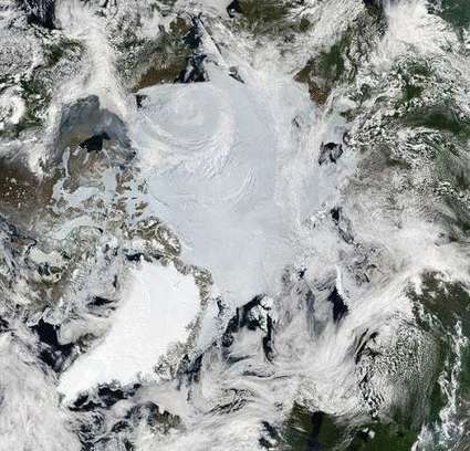
Scooped by
Dr. Stefan Gruenwald
October 20, 2016 6:47 PM
|
About 71% of the Earth is covered in water. Most of that is in oceans, rivers, and lakes, but some is frozen in the Earth's two ice sheets. Those ice sheets, which cover most of Greenland and Antarctica, only contain 2% of the world's total water supply, but a whopping 70% of the Earth's fresh water. Scientists estimate that if the Antarctic Ice Sheet—the larger of the two—melted, sea level would rise by around 60 meters (200 feet). Not only that, but it could affect the weather: a study showed that less sea ice in the Arctic causes rainier summers in western Europe, and another study suggests that it's causing more extreme heat waves in the United States and elsewhere. And counterintuitively, melting ice also causes more melting ice. A 2016 study found that a shrinking in the Greenland Ice Sheet causes what are known as "blocking events," where high-pressure systems park themselves on top of one area for days or even weeks. This brings warm, moist air that heats the surface below and causes even more ice to melt. Explore the relationship between polar ice and climate change in the videos below.
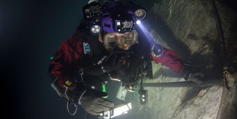
Czech abyss is so deep the Empire State Building could fit inside. A team of explorers has found the deepest underwater cave yet discovered, with a bottom that lies at least 1,325 feet below the water's surface. Polish explorer Krzysztof Starnawski, who led the team, first explored the cave -- named Hranická Propast and located near the Czech town of Hranice -- in 1999, and instantly knew it was an unusual find. He told National Geographic, which sponsored his most recent expedition, that hot water saturated with carbon dioxide bubbled up like a volcano, and made his exposed skin itch. A series of dives over the years hinted at the abyss' depth. In 2014, he reached 656 feet, thinking he had found the bottom, only to discover a very narrow opening that led to a vertical tunnel. The following year, some of the rock in the cave had crumbled, widening the opening and making it possible for him to squeeze through. He reached a depth of 869 feet and released a probe, which at 1,214 feet landed on what was probably a pile of debris from the collapsed passage above.
Via Kathy Bosiak
|
|
Scooped by
Dr. Stefan Gruenwald
September 19, 2016 3:08 PM
|
Geologic strain of tides during full and new moons could increase magnitude of tremors. Big earthquakes, such as the ones that devastated Chile in 2010 and Japan in 2011, are more likely to occur during full and new moons — the two times each month when tidal stresses are highest. Earth’s tides, which are caused by a gravitational tug-of-war involving the Moon and the Sun, put extra strain on geological faults. Seismologists have tried for decades to understand whether that stress could trigger quakes. They generally agree that the ocean’s twice-daily high tides can affect tiny, slow-motion tremors in certain places, including California’s San Andreas fault1 and the Cascadia region2 of the North American west coast. But a new study, published on 12 September in Nature Geoscience3, looks at much larger patterns involving the twice-monthly tides that occur during full and new moons. It finds that the fraction of high magnitude earthquakes goes up globally as tidal stresses rise. Satoshi Ide, a seismologist at the University of Tokyo, and his colleagues investigated three separate earthquake records covering Japan, California and the entire globe. For the 15 days leading up to each quake, the scientists assigned a number representing the relative tidal stress on that day, with 15 representing the highest. They found that large quakes such as those that hit Chile and Tohoku-Oki occurred near the time of maximum tidal strain — or during new and full moons when the Sun, Moon and Earth align. For more than 10,000 earthquakes of around magnitude 5.5, the researchers found, an earthquake that began during a time of high tidal stress was more likely to grow to magnitude 8 or above.
|
|
Scooped by
Dr. Stefan Gruenwald
September 19, 2016 2:43 PM
|
The temperature of the Earth’s crust ranges considerably. At its outer edge, where it meets the atmosphere, the crust’s temperature is the same temperature as that of the air. So, it might be as hot as 35 °C in the desert and below freezing in Antarctica. On average, the surface of the Earth’s crust experiences temperatures of about 14°C. However, the hottest temperature ever recorded was 70.7°C (159°F), which was taken in the Lut Desert of Iran as part of a global temperature survey conducted by scientists at NASA’s Earth Observatory. Meanwhile, the coldest temperature ever recorded on Earth was measured at the Soviet Vostok Station on the Antarctic Plateau – which reached an historic low of -89.2°C (-129°F) on July 21st, 1983. That’s quite the range already. But consider the fact that the majority of the Earth’s crust lies beneath the oceans. Far from the Sun, temperatures can reach as low as 0-3° C (32-37.5° F) where the water reaches the crust. Still, a lot balmier than a cold night in Antarctica!
|
|
Scooped by
Dr. Stefan Gruenwald
August 19, 2016 12:25 PM
|
“The Arctic sea ice responded very rapidly to past climate changes. During the coldest periods of the past 90,000 years the sea ice edge spread relatively quickly to the Greenland-Scotland Ridge, and probably far into the Atlantic Ocean.” says Ulrike Hoff, a researcher at Centre for Arctic Gas Hydrate, Environment and Climate (CAGE). Sea ice amplifies the climate changes that are occurring at any given time. Its growth and melting has profound effects on climate, the marine environment and ocean circulation. Hoff and colleagues studied the past distribution of sea ice, in the so far longest existing sea ice record in a marine sediment core. The core was retrieved from 1200m water depth from the ocean floor of the Nordic Seas, just off the Faroe Islands. The core represents 90,000 years of sediment layers, and it is by studying those layers that scientist can reveal the changes in sea ice and past climate. It was the tiniest of evidence in these layers that brought this strong confirmation of sea ice behavior to light. They are a type of phytoplankton, called diatoms, and they are everywhere around you. Diatoms are single celled algae with a cell wall made up of silica. “They are the golden brown coating in the glass of a street lamp, and shiny stuff in your make-up. They are even used in tooth paste as a cleaning agent.,” says Hoff. “Diatoms are truly amazing, and can be preserved in marine and lake sediments for millions of years. I have personally examined diatom fossils that are 65 million of years old, and they look much the same as the diatoms that we find living today.”
|