Your new post is loading...

|
Scooped by
Dr. Stefan Gruenwald
August 16, 2019 12:35 PM
|
If lightning strikes near the North Pole, and no one is around to hear it, does it make a sound? Yes, because there’s a global array of sensors that’s always listening, pinpointing lightning strikes in time and space from as far away as 6,000 miles. Recently, the North Pole played host to a rare thunderstorm, an event that may become less rare as climate change ramps up. And it would have gone entirely unnoticed by faraway humans if it weren’t for the assistance of a company called Vaisala, which operates the sensor network and uses it to triangulate a lightning strike, feeding the data to outfits like the National Weather Service. “This is a relatively new system, and so our ability to detect lightning that far north has drastically improved over the last 5 to 10 years,” says Alex Young, a meteorologist with the National Weather Service in Fairbanks, Alaska. “As opposed to: who knows if an event like this happened 30 years ago?”
|
|
Scooped by
Dr. Stefan Gruenwald
July 19, 2019 11:48 AM
|
The ice sheet covering West Antarctica is at risk of sliding off into the ocean. While further ice-sheet destabilization in other parts of the continent may be limited by a reduction of greenhouse gas emissions, the slow, yet inexorable loss of West Antarctic ice is likely to continue even after climate warming is stabilized. A collapse might take hundreds of years but will raise sea levels worldwide by more than three meters. A team of researchers from the Potsdam Institute for Climate Impact Research (PIK) is now scrutinizing a daring way of stabilizing the ice sheet: Generating trillions of tons of additional snowfall by pumping ocean water onto the glaciers and distributing it with snow canons. This would mean unprecedented engineering efforts and a substantial environmental hazard in one of the world’s last pristine regions – to prevent long-term sea level rise for some of the world’s most densely populated areas along coastlines from the US to China. “The fundamental trade-off is whether we as humanity want to sacrifice Antarctica to safe the currently inhabited coastal regions and the cultural heritage that we have built and are building on our shores. It is about global metropolises, from New York to Shanghai, which in the long term will be below sea level if nothing is done“ explains Anders Levermann, physicist at the Potsdam Institute for Climate Impact Research (PIK) and Columbia University and one of the authors of the study. “The West Antarctic Ice Sheet is one of the tipping elements in our climate system. Ice loss is accelerating and might not stop until the West Antarctic ice sheet is practically gone.”
|
|
Rescooped by
Dr. Stefan Gruenwald
from Soggy Science
June 10, 2019 2:05 PM
|
A large space object about a mile wide is believed to have crashed into Earth around 1.2 Billion (bn) years ago. The location of an ancient impact crater made by the biggest asteroid ever to hit Britain has been traced to a spot under the sea between mainland Scotland and the Outer Hebrides. Researchers at Oxford and Aberdeen universities found signs of the violent collision in Scotland on a field trip in 2008, but have only now pinpointed where the asteroid came down. Tests on rocks near Ullapool in north-west Scotland revealed that an object about a mile wide had crashed into a spot in the Minch, a strait that separates the mainland and northern Inner Hebrides from Lewis and Harris, six miles west of the village of Lochinver. The 38,000 mph collision, which thumped a 12-mile-wide crater into the ground, happened 1.2 bn years ago, when most life on Earth was still in the oceans and plants had yet to take root on land. At the time, what is now Scotland was a semi-arid land that lay close to the equator. “The impact would have sent huge roiling clouds of dust and gas at several hundred degrees in all directions from the impact site,” said Ken Amor, an Oxford researcher who led the latest study. What is left of the crater is submerged in 200-meter-deep water and covered in sediment.
Via Grant W. Graves
|
|
Scooped by
Dr. Stefan Gruenwald
January 15, 2019 12:53 AM
|
The destruction that a large earthquake can cause often doesn’t end when the ground stops shaking. Many produce aftershocks, smaller tremors hours or even days later caused by the ground’s reaction to the first quake. These aftershocks can sometimes cause more damage than the primary quake. And though we can usually predict the size of an aftershock, we haven’t been so great at predicting its location. Now, that could change. Researchers from Harvard University and Google’s AI division have created a neural network that can assess how likely it is that a particular location will experience an aftershock. The best part? It’s more accurate than the best existing models. They published their study Wednesday in the journal Nature.
|
|
Scooped by
Dr. Stefan Gruenwald
November 21, 2018 8:01 PM
|
Industrial emissions of ozone depleting substances (ODSs) during the second half of the twentieth century have led to one of the most visible human impacts on the Earth: the Antarctic ozone hole. The ozone loss intensified in the 1980s and reached the level of saturation (i.e., complete loss of ozone) due to the high levels of ODSs in the atmosphere. Significant changes in the southern hemispheric climate have been observed in the past decades due to this unprecedented ozone loss. Although the most recent studies suggest healing in the Antarctic ozone hole, the status of ozone in the loss saturation layer (~13–21 km) has not been discussed in detail. Now, a comprehensive analysis of vertical, spatial and temporal evolution of ozone loss saturation (ozone mixing ratio ≤ 0.1 ppmv) in the Antarctic vortex using high resolution measurements for the 1979–2017 period reveals that the loss saturation began in 1987 and continued to occur in all winters thereafter, except in the major warming winters of 1988 and 2002. However, this recent analysis shows a clear reduction in the frequency of occurrence of ozone loss saturation over the period 2001–2017 consistently throughout various datasets (e.g., ozonesonde and satellite measurements of ozone profiles and total columns), thereby revealing the emergence of an important milestone in ozone recovery.
|
|
Scooped by
Dr. Stefan Gruenwald
August 8, 2018 11:33 AM
|
The oxygenation of Earth’s atmosphere was thanks, in part, to iron and silica particles in ancient seawater, according to a new study by geomicrobiologists at the University of Alberta. But these results solve only part of this ancient mystery. Early organisms called cyanobacteria produced oxygen through oxygenic photosynthesis, resulting in the oxygenation of Earth’s atmosphere. But cyanobacteria needed protection from the sun’s UV radiation in order to evolve. That’s where iron and silica particles in ancient seawater come in, according to Aleksandra Mloszewska, a former PhD student who conducted this research under the supervision of Kurt Konhauser, professor in the Department of Earth and Atmospheric Sciences, and George Owttrim, professor in the Department of Biological Sciences. The research team characterized the effect of UV stress on cyanobacteria and the degree of radiation through the seawater medium through a combination of microbiological, spectroscopic, geochemical and modeling techniques. Their results show that the presence of high silica and iron concentrations in early sea water allowed for the formation of iron-silica precipitates that remained suspended in the ocean for extended periods of time. “In effect, the iron-silica particles acted as an ancient ‘sunscreen’ for the cyanobacteria, protecting them from the lethal effects of direct UV exposure,” said Konhauser, the senior author from UAlberta. “This was critical on the early Earth before a sufficiently thick ozone layer was established that could enable marine plankton to spread across the globe, as is the case today.”
|
|
Scooped by
Dr. Stefan Gruenwald
July 9, 2018 7:47 PM
|
The Jeerinah Formation in Western Australia, where a UW-led team found a sudden shift in nitrogen isotopes. “Nitrogen isotopes tell a story about oxygenation of the surface ocean, and this oxygenation spans hundreds of kilometers across a marine basin and lasts for somewhere less than 50 million years,” said lead author Matt Koehler. Earth’s oxygen levels rose and fell more than once hundreds of millions of years before the planetwide success of the Great Oxidation Event about 2.4 billion years ago, new research from the University of Washington shows. The evidence comes from a new study that indicates a second and much earlier “whiff” of oxygen in Earth’s distant past — in the atmosphere and on the surface of a large stretch of ocean — showing that the oxygenation of the Earth was a complex process of repeated trying and failing over a vast stretch of time. The finding also may have implications in the search for life beyond Earth. Coming years will bring powerful new ground- and space-based telescopes able to analyze the atmospheres of distant planets. This work could help keep astronomers from unduly ruling out “false negatives,” or inhabited planets that may not at first appear to be so due to undetectable oxygen levels. “The production and destruction of oxygen in the ocean and atmosphere over time was a war with no evidence of a clear winner, until the Great Oxidation Event,” said Matt Koehler, a UW doctoral student in Earth and space sciences and lead author of a new paper published the week of July 9 , 2018 in the Proceedings of the National Academy of Sciences (PNAS).
|
|
Scooped by
Dr. Stefan Gruenwald
June 5, 2018 1:01 AM
|
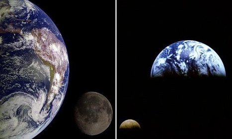
The moon is moving away from Earth at a rate of 1.5 inches (3.82 cm) per year. As it drifts further from Earth, its gravitational pull weakens. This reduces the speed of Earth's spin and means days are slowly getting longer. Scientists discovered that a day used to be 18 hours long 1.4 billion years ago.
Eventually, days will lengthen significantly as the Earth's only celestial body pulls away — reducing the gravitational pull on our planet. Researchers found the shorter days were caused, at least in part, by the moon's closer proximity to Earth. The closer the moon was to the surface of the planet, the stronger its gravitational pull and the quicker it made Earth spin. This contributed to the days on Earth lasting six hours less than they do today. Prof Stephen Meyers, of the University of Wisconsin-Madison and co-author of the study, said: 'As the moon moves away, the Earth is like a spinning figure skater who slows down as they stretch their arms out.'
Professor Meyers and his team attempted to chronicle how the relationship between Earth and the moon has altered over time. They used a complex statistical method that links astronomical theory with geological observation — known as astro-chronology. Using this method, they were able to look back at Earth's geologic past and reconstruct the history of the solar system.
Professor Meyers said: 'One of our ambitions was to use astro-chronology to tell time in the most distant past, to develop very ancient geological time scales. 'We want to be able to study rocks that are billions of years old in a way that is comparable to how we study modern geologic processes.'
|
|
Scooped by
Dr. Stefan Gruenwald
May 2, 2018 2:42 PM
|
A study of the most recent near-reversals of the Earth's magnetic field by an international team of researchers, including the University of Liverpool, has found it is unlikely that such an event will take place anytime soon. There has been speculation that the Earth's geomagnetic fields may be about to reverse , with substantial implications, due to a weakening of the magnetic field over at least the last two hundred years, combined with the expansion of an identified weak area in the Earth's magnetic field called the South Atlantic Anomaly, which stretches from Chile to Zimbabwe. In a paper published in the Proceedings of the National Academy of Sciences, a team of international researchers model observations of the geomagnetic field of the two most recent geomagnetic excursion events, the Laschamp, approximately 41,000 years ago, and Mono Lake, around 34,000 years ago, where the field came close to reversing but recovered its original structure. The model reveals a field structures comparable to the current geomagnetic field at both approximately 49,000 and 46,000 years ago, with an intensity structure similar to, but much stronger than, today's South Atlantic Anomaly (SAA); their timing and severity is confirmed by records of cosmogenic nuclides. However, neither of these SAA-like fields developed into an excursion or reversal. Richard Holme, Professor of Geomagnetism at the University of Liverpool, said: "There has been speculation that we are about to experience a magnetic polar reversal or excursion. However, by studying the two most recent excursion events, we show that neither bear resemblance to current changes in the geomagnetic field and therefore it is probably unlikely that such an event is about to happen.
|
|
Scooped by
Dr. Stefan Gruenwald
April 12, 2018 6:19 PM
|
This would allow us to gain a new understanding of extraterrestrial life. Life on other planets might not be located the most obvious of places. While researchers used to think that Earth-like planets such as Mars or Venus were capable of holding life, modern research has shown that places like Europa or Enceladus are much more likely to be hospitable (Europa and Enceladus are two frozen moons of Jupiter and Saturn respectively). However, astronomers have evidence that beneath the frozen surface lies a vast ocean of liquid where life may very well thrive. Researchers want to explore this avenue before actually landing a shuttle on the surface of these moons (which may take a very long time) and the best way to do that is by studying subglacial lakes. Subglacial lakes are bodies of water perfectly sealed under a glacier — typically an ice cap or ice sheet. There are 400 known subglacial lakes in the world, most of which can be found in Antarctica, with Lake Vostok being probably the most well known. Since they’re sealed off from the rest of the world, life can develop andadapt independently — this essentially means that subglacial lakes are potentially unique microbial habitats which can provide information about how life might have developed on places like Europa. Now, lead author Anja Rutishauser, a Ph.D. student at the University of Alberta, has found the first subglacial lakes in the Canadian High Arctic. “If there is microbial life in these lakes, it has likely been under the ice for at least 120,000 years, so it likely evolved in isolation,” Rutishauser said. “If we can collect a sample of the water, we may determine whether microbial life exists, how it evolved, and how it continues to live in this cold environment with no connection to the atmosphere.” What makes these newly discovered lakes extra special is that they seem to contain very salty water — all other subglacial lakes we know of are thought to contain freshwater, or only mildly saline water. All subglacial lakes are good analogs for life beyond Earth, but the hypersaline nature of these newly discovered lakes makes them particularly tantalizing analogs for ice-covered moons in our solar system, according to the researchers. There is strong evidence that Jupiter’s icy moon Europa contains hypersaline water. The lake was discovered using remote sensing, which is promising, especially considering that NASA’s Europa Clipper mission, which is set to launch sometime in the 2020s and take samples from Europa, will use similar remote sensing techniques. An analysis of the radar data shows that the lakes are located 550 to 750 meters beneath the Devon Ice Cap, one of the largest ice caps in the Canadian Arctic. They’ve not had contact with the outside world for tens of thousands of years.
|
|
Scooped by
Dr. Stefan Gruenwald
February 11, 2018 1:25 PM
|
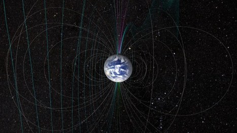
The magnetic field of the Earth is like a shield of protection that saves the atmosphere and life on Earth from the bombardment of hazardous charged particles from space. However, the strength of the magnetic field is not constant and is subject to change that will be accompanied by many consequences. Studies have documented that the Earth's magnetic field changes direction and the reversal happens every several hundred thousand years. The process is often preceded by a drastic weakening of the geomagnetic field. Some of the trends are pointing to the fact that a reversal of Earth's magnetic field is due. The prime signal of it is the depletion of the magnetic field at the rate of 5 percent a century. This is considered a forerunner to the reversal of the magnetic poles, and the consequences will include a breakdown of communication systems and heavy damage to energy infrastructure and electricity transmission systems. So, it is reasonable to assume that the reversal of the geomagnetic field can happen in the next 2,000 years. However, an exact date for the reversal in geomagnetic field is too hard to predict. Over the years, the magnetic power of the Earth has been declining at an alarming rate, especially in the last 160 years. This weakening has been explicit in a vast area in the Southern Hemisphere between Zimbabwe and Chile and known as the South Atlantic Anomaly. Data from observatories show that an unusual feature of reversed polarity beneath southern Africa exists at the core-mantle boundary where the liquid iron in the outer core overlaps with the relatively hard part of the Earth's interior. The geomagnetic field is generated by the flow of molten iron in the liquid outer core of Earth. In the South Atlantic Anomaly, the magnetic field is weak and satellites orbiting the region are vulnerable as protection against radiation is too low and satellite electronics are exposed to radiation risk. At this part, there is a reversal of polarity vis-a-vis the average global magnetic field. According to experts, this patch is the main contributor to the South Atlantic Anomaly, with simulations having shown that such patches like the one below Southern Africa do appear preceding geomagnetic reversals.
|
|
Scooped by
Dr. Stefan Gruenwald
November 20, 2017 2:44 PM
|
Every so often, the Earth’s rotation slows by a few milliseconds per day. This is inconsequential to the average human, and causes only mild annoyance to the people whose job it is to measure Earth’s rotation with great precision. That may be about to change, if the hypothesis set out by two geologists proves true. In a study published in Geophysical Research Letters earlier this year, Roger Bilham of the University of Colorado and Rebecca Bendick of the University of Montana predict that, because of Earth’s slowing rotation, the world will see a significant spike in large earthquakes in 2018. To make this prediction, Bilham and Bendick studied every earthquake since 1900 that recorded more than 7.0 on the moment magnitude scale. They found that approximately every 32 years, there is an uptick in these large quakes. The only factor that strongly correlates is a slight slowing of the Earth’s rotation in a five-year period before the uptick.
|
|
Scooped by
Dr. Stefan Gruenwald
November 10, 2017 2:27 PM
|
According to NASA, the ozone hole reached its peak extent on Sept. 11, covering an area about two and a half times the size of the United States – 7.6 million square miles in extent - and then declined through the remainder of September and into October. NOAA ground- and balloon-based measurements also showed the least amount of ozone depletion above the continent during the peak of the ozone depletion cycle since 1988. NOAA and NASA collaborate to monitor the growth and recovery of the ozone hole every year. “The Antarctic ozone hole was exceptionally weak this year,” said Paul A. Newman, chief scientist for Earth Sciences at NASA's Goddard Space Flight Center in Greenbelt, Maryland. “This is what we would expect to see given the weather conditions in the Antarctic stratosphere.” The smaller ozone hole in 2017 was strongly influenced by an unstable and warmer Antarctic vortex – the stratospheric low pressure system that rotates clockwise in the atmosphere above Antarctica. This helped minimize polar stratospheric cloud formation in the lower stratosphere. The formation and persistence of these clouds are important first steps leading to the chlorine- and bromine-catalyzed reactions that destroy ozone, scientists said. These Antarctic conditions resemble those found in the Arctic, where ozone depletion is much less severe. In 2016, warmer stratospheric temperatures also constrained the growth of the ozone hole. Last year, the ozone hole reached a maximum 8.9 million square miles, 2 million square miles less than in 2015. The average area of these daily ozone hole maximums observed since 1991 has been roughly 10 million square miles. Although warmer-than-average stratospheric weather conditions have reduced ozone depletion during the past two years, the current ozone hole area is still large because levels of ozone-depleting substances like chlorine and bromine remain high enough to produce significant ozone loss. Scientists said the smaller ozone hole extent in 2016 and 2017 is due to natural variability and not a signal of rapid healing. First detected in 1985, the Antarctic ozone hole forms during the Southern Hemisphere’s late winter as the returning sun’s rays catalyze reactions involving man-made, chemically active forms of chlorine and bromine. These reactions destroy ozone molecules. Thirty years ago, the international community signed the Montreal Protocol on Substances that Deplete the Ozone Layer and began regulating ozone-depleting compounds. The ozone hole over Antarctica is expected to gradually become less severe as chlorofluorocarbons—chlorine-containing synthetic compounds once frequently used as refrigerants – continue to decline. Scientists expect the Antarctic ozone hole to recover back to 1980 levels around 2070.
|
|
|
Scooped by
Dr. Stefan Gruenwald
August 8, 2019 1:41 PM
|
The last reversal of Earth's magnetic poles happened long before humans could record it, but research on the flow of ancient lava has helped scientists estimate the duration of this strange phenomenon. A team of researchers used volcanic records to study Earth's last magnetic-field reversal, which occurred about 780,000 years ago. They found that this flip may have taken much longer than researchers previously thought, the scientists reported in a new study. Earth's magnetic field has flipped dozens of times in the past 2.5 million years, with north becoming south and vice versa. Scientists know the last reversal took place during the Stone Age, but they have little information about the duration of this phenomenon and when the next "flip" might occur.
|
|
Scooped by
Dr. Stefan Gruenwald
July 18, 2019 11:28 AM
|
In a world where energy consumption is on the rise, our only hope is the development of new energy-generation technologies. Although currently used renewable energy sources such as wind and solar energy have their merits, there is a gigantic, permanent, and untapped energy source quite literally under our noses: geothermal energy. Generating electricity from geothermal energy requires devices that can somehow make use of the heat within the Earth's crust. Recently, a team of scientists at Tokyo Tech, led by Dr. Sachiko Matsushita, have made great progress in the understanding and development of sensitized thermal cells (STCs), a kind of battery that can generate electric power at 100 degrees C or less. Several methods for converting heat into electric power exist, however, their large-scale application is not feasible. For example, hot-and-cold redox batteries and devices based on the Seebeck effect are not possible to simply bury them inside a heat source and exploit them. Dr. Matsushita's team have previously reported the use of STCs as a new method for converting heat directly into electric power using dye-sensitized solar cells. They also replaced the dye with a semiconductor to allow the system to operate using heat instead of light. The graph above illustratively represents the STC, a battery that consists of three layers sandwiched between electrodes: an electron transport layer (ETM), a semiconductor layer (germanium), and a solid electrolyte layer (copper ions). In short, electrons go from a low-energy state to a high-energy state in the semiconductor by becoming thermally excited and then get transferred naturally to the ETM. Afterwards, they leave through the electrode, go through an external circuit, pass through the counter electrode, and then reach the electrolyte. Oxidation and reduction reactions involving copper ions take place at both interfaces of the electrolyte, resulting in low-energy electrons being transferred to the semiconductor layer so that the process can begin anew, thus completing an electric circuit. However, it was not clear at that time whether such a battery could be used as a perpetual engine or if the current would stop at some point. After testing, the team observed that electricity indeed stopped flowing after a certain time and proposed a mechanism explaining this phenomenon. Basically, current stops because the redox reactions at the electrolyte layer stop owing to the relocation of the different types of copper ions. Most importantly, and also surprisingly, they found out that the battery can revert this situation itself in the presence of heat by simply opening the external circuit for some time; in other words, by using a simple switch. "With such a design, heat, usually regarded as low-quality energy, would become a great renewable energy source," states Matsushita.
|
|
Scooped by
Dr. Stefan Gruenwald
March 22, 2019 3:17 PM
|
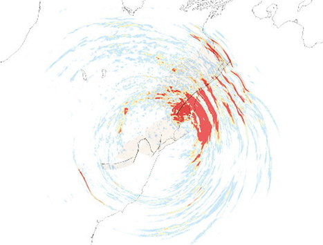
The 2016 Kaikoura earthquake (magnitude 7.8) on the South Island of New Zealand is among the most intriguing and best-documented seismic events anywhere in the world – and one of the most complex. The earthquake exhibited a number of unusual features, and the underlying geophysical processes have since been the subject of controversy. LMU geophysicists Thomas Ulrich and Dr. Alice-Agnes Gabriel, in cooperation with researchers based at the Université Côte d'Azur in Valbonne and at Hong Kong Polytechnic University, have now simulated the course of the earthquake with an unprecedented degree of realism. Their model, which was run on the Bavarian Academy of Science’s supercomputer SuperMUC at the Leibniz Computing Center (LRZ) in Munich, elucidates dynamic reasons for such uncommon multi-segment earthquake. This is an important step towards improving the accuracy of earthquake hazard assessments in other parts of the world. Their findings are being published in Nature Communications.
|
|
Scooped by
Dr. Stefan Gruenwald
December 6, 2018 1:39 PM
|
Rising sea levels could become overwhelming sooner than previously believed, according to the authors of the most comprehensive study yet of the accelerating ice melt in Greenland. Run-off from this vast northern ice sheet – currently the biggest single source of meltwater adding to the volume of the world’s oceans – is 50% higher than pre-industrial levels and increasing exponentially as a result of manmade global warming, says the paper, published in Nature on Wednesday. Almost all of the increase has occurred in the past two decades – a jolt upwards after several centuries of relative stability. This suggests the ice sheet becomes more sensitive as temperatures go up. “Greenland ice is melting more in recent decades than at any point in at least the last four centuries, and probably more than at any time in the last seven to eight millennia,” said the lead author Luke Trusel, of Rowan University. “We demonstrate that Greenland ice is more sensitive to warming today than in the past – it responds non-linearly due to positive feedbacks inherent to the system. Warming means more today than it did even just a few decades ago.”
|
|
Scooped by
Dr. Stefan Gruenwald
August 8, 2018 8:38 PM
|
Blood Falls is an aptly named feature in Antarctica. The 100-foot stream of water running down the side of a glacier is a deep, rich, blood red. Though we’ve known for decades what causes the red color, it took more than 100 years for scientists to discover the source of Blood Falls: a secret, ancient, underground lake. Blood Falls were first discovered by Australian explorer Griffith Taylor during an expedition in 1911. At the time, he and other explorers guessed that the red color might be caused by algae living in the water. “It's unearthly, it's unreal,” Steve Martin, an Antarctic historian, told Motherboard on the latest episode of Science Solved It. “So when [explorer] Griffith Taylor and his friends saw the blood falls flowing red out of the end of the Taylor Glacier, they must have thought it was just another incredible oddity in a very strange part of the world.” Though scientists later realized it was the high iron content that turned the water bloody red (the water oxidizes and turns red when exposed to air), they still didn’t know where the water was coming from or how the falls formed. “We did not know where the brine came from. We didn't know how it made its way through the glacier,” explained Erin Pettit, one of the scientists who solved the mystery of Blood Falls. “If the brine started at the base of the glacier, it should have continued to flow at the base.” The Pettit team published their findings and were able to confirm them when a drilling team visited the region the following year. By using the map Pettit and her team had created, the drilling crew located where the underground source should be and got to work. Sure enough, red brine squirted up around the drill. Along with finding the source of Blood Falls, the scientists also provided more context for life forms that had previously been discovered there: tiny microbes capable of surviving in super salty, high-iron, very cold water, without sunlight, under a glacier. It turns out these extremophiles were even more extreme than previously recognized, and studying them further can help us understand how life might survive in other extreme environments, such as outer space. “That first discovery is leading us on a track of further discovery and further explanation,” Martin said. “Antarctica still has not yielded up all her secrets.”
|
|
Scooped by
Dr. Stefan Gruenwald
July 31, 2018 11:27 PM
|
The human population on Earth is about 7.6 billion people (and counting). But according to a new global census of biomass, humans are barely a rounding error compared to the rest of life on Earth. As Seth Borenstein at The Associated Press reports, the biomass of humanity—measured by the dry-weight of carbon that makes up our bodies—is equivalent to just one ten-thousandth of all biomass on our planet. Anyone who has walked through a jungle or wandered a grassland may already have guessed that humans are a pretty small part of Earth’s organic matter. The carbonaceous winners are plants, which make up about 80 percent of all biomass on Earth. Bacteria comes in second at 13 percent and fungus is third at just 2 percent. Of the 550 gigatons of biomass carbon on Earth, animals make up about 2 gigatons, with insects comprising half of that and fish taking up another 0.7 gigatons. Everything else, including mammals, birds, nematodes and mollusks are roughly 0.3 gigatons, with humans weighing in at 0.06 gigatons. The research appears in The Proceedings of the National Academy of Sciences. “The fact that the biomass of fungi exceeds that of all animals’ sort of puts us in our place,” Harvard evolutionary biologist James Hanken, who was not involved with the study, tells Borenstein. The animal species with the biggest biomass is Antarctic krill.
|
|
Scooped by
Dr. Stefan Gruenwald
June 13, 2018 7:52 PM
|
Nitrogen fixation in the surface ocean impacts global marine nitrogen bioavailability and thus microbial primary productivity. Until now, cyanobacterial populations have been viewed as the main suppliers of bioavailable nitrogen in this habitat. Although PCR amplicon surveys targeting the nitrogenase reductase gene have revealed the existence of diverse non-cyanobacterial diazotrophic populations, subsequent quantitative PCR surveys suggest that they generally occur in low abundance. Now, a team of scientists used state-of-the-art metagenomic assembly and binning strategies to recover nearly one thousand non-redundant microbial population genomes from the TARA Oceans metagenomes. Among these, they provided the first genomic evidence for non-cyanobacterial diazotrophs inhabiting surface waters of the open ocean, which correspond to lineages within the Proteobacteria and, most strikingly, the Planctomycetes. Members of the latter phylum are prevalent in aquatic systems, but have never been linked to nitrogen fixation previously. Moreover, using genome-wide quantitative read recruitment, the group of scientists were able to demonstrate that the discovered diazotrophs were not only widespread but also remarkably abundant (up to 0.3% of metagenomic reads for a single population) in both the Pacific Ocean and the Atlantic Ocean northwest. These results extend decades of PCR-based gene surveys, and substantiate the importance of heterotrophic bacteria in the fixation of nitrogen in the surface ocean.
|
|
Scooped by
Dr. Stefan Gruenwald
May 9, 2018 2:08 PM
|
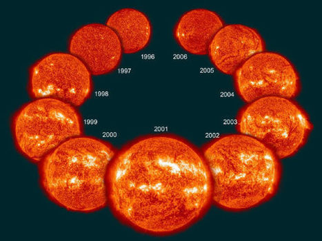
Pioneering new research from the University of Exeter, UK, has revealed when the 11-year solar cycle is in its ‘weaker’ phase, there are warm spells across the Arctic in winter, as well as heavy snowfall across Eurasia. Dr. Indrani Roy, a researcher at the College of Engineering, Mathematics and Physical Sciences at the University of Exeter, evaluated the impact of the 11-year solar cycle — measured in terms of solar sunspot number (SSN) — as a driving factor to modulate Arctic and surrounding climate. “We explored how the solar cycle — a periodic change in the Sun’s activity including changes in the levels of solar UV radiation and changes in the SSNs — can be linked with the Polar vortex and Arctic Oscillation phenomenon, which affects winter Arctic and Eurasian climate,” Dr. Roy explained. “It subsequently can influence weather conditions in Europe, including the UK, Scandinavia and Asia,” she said. The study observed that during periods when the winter SSN falls below average, the Arctic warming extends from the lower troposphere to high up in the upper stratosphere. On the other hand there is a cooling when SSN is above average. “In spite of all other influences and complexities, it is still possible to segregate a strong influence from the Sun,” Dr. Roy noted. “There are reductions of sea-ice in the Arctic and a growth in the Eurasian sector is observed in recent winters. This study shows those trends are related and current weaker solar cycle is contributing to that.”
|
|
Rescooped by
Dr. Stefan Gruenwald
from Geology
April 13, 2018 5:08 PM
|
Mapping minerals from space was one of the main motivating reasons for creating the earliest multispectral satellite systems such as the Landsat satellites when they were launched in 1972. More modern systems, including the recent Landsat 8,Sentinel-2, and ASTER, have improved upon this endeavor by giving more accurate readings at higher resolutions. Using spectral response functions along with pixel aggregate has shown that the Sentinel-2 satellite compares favorably to maps created by ASTER, which since the early 2000s had become among the leading multispectral satellite systems for geological mapping. In particular, shortwave infrared (SWIR; 0.9-1.7 microns for wavelength) and visible and near-infrared bands (VNIR; 0.36-1.05 microns for wavelength) show comparable results in detecting iron. In 2000, NASA had launched its Hyperion system, which covers 0.4-2.5/spi mu/m spectral range with 242 bands. While hyperspectral imagery has been established with aircraft systems, where the wide band coverage means that many types of minerals could potentially be differentiated more easily, this type of system was not used on satellites. Hyperion was NASA’s way of testing the utility of hyperspectral satellite imagery for various applications. Because of the increased band coverage, what has been useful about Hyperion is that it does provide capabilities to detect a wide variety of minerals, comparable to some extent to some aircraft systems. Minerals such as carbonates, chlorite, epidote, kaolinite, alunite, buddingtonite, muscovite, hydrothermal silica, and zeolite are evident using different bands from the system. In many regions, the most common surface minerals are found within clays. This has required new techniques to be made to utilize satellite systems to better map types of clays and minerals found within. Using SWIR and thermal infrared (TIR) bands, it has become possible to differentiate clay types that include illite from montmorillonite clays. This can have important implications for agricultural areas or areas that have greater or worse water retention, including groundwater deposits, due to clay and mineral types found affecting water deposits. Variation in the clay signatures could also be potentially used to monitor erosion activities, including wind and water erosion that affects surfaces.
Via Dr. Catherine Russell
|
|
Scooped by
Dr. Stefan Gruenwald
March 19, 2018 7:35 PM
|
The phenomenon of ‘Steve’ - a glowing arc seen in Alberta, Canada by amateur scientists – has now been named by Nasa the unusual name 'Steve'.. The history behind this discovery is the following: A group of citizen scientists in Alberta, Canada, weren’t sure what the glowing purple (sometimes green) arc in the night sky they had been photographing really was. Nor were the scientists Elizabeth MacDonald, a space physicist at Nasa, and Eric Donovan, an associate professor of physics and astronomy at the University of Calgary; the group – known as the Alberta Aurora Chasers, who photograph the Aurora Borealis, or Northern Lights – showed them their pictures in a pub. It wasn’t, Donovan told them, a proton aurora (the northern lights are normally a result of electrons colliding with gases in the Earth’s atmosphere), as they had thought. “They pulled up this beautiful photograph of this thing,” Donovan told the New York Times last year. “And I’m like, ‘I don’t know what that is, but it’s not the proton aurora.’” It needed a name: “Steve” sounded as good as any. It was inspired by a scene in the 2006 animation Over the Hedge, in which the animal characters are confronted with a mysterious row of shrubs. The phenomenon does now have a backronym of an official name: strong thermal emission velocity enhancement (Steve for short). It can be spotted further south than the northern lights and is thought to be, according to a recently published paper, “an optical manifestation” of another phenomenon, the sub-auroral ion drift. Steve is a visible strip of ionized gas, traveling at 4 miles/s. Last week, Nasa called on citizen scientists and photographers to help with its research into Steve and report sightings to the Aurorasaurus project. It is, Donovan has said, “a truly new era” of collaboration between amateur scientists and professionals.
|
|
Scooped by
Dr. Stefan Gruenwald
December 11, 2017 11:30 PM
|
In late December 2014, a submarine volcano in the South Pacific Kingdom of Tonga erupted, sending a violent stream of steam, ash and rock into the air. The ash plumes rose as high as 30,000 feet (9 kilometers) into the sky, diverting flights. When the ash finally settled in January 2015, a newborn island with a 400-foot (120-meter) summit nestled between two older islands – visible to satellites in space.
The newly formed Tongan island, unofficially known as Hunga Tonga-Hunga Ha'apai after its neighbors, was initially projected to last a few months. Now it has a 6- to 30-year lease on life, according to a new NASA study.
Hunga Tonga-Hunga Ha'apai is the first island of this type to erupt and persist in the modern satellite era, it gives scientists an unprecedented view from space of its early life and evolution. The new study offers insight into its longevity and the erosion that shapes new islands. Understanding these processes could also provide insights into similar features in other parts of the solar system, including Mars.
|
|
Scooped by
Dr. Stefan Gruenwald
November 20, 2017 2:20 PM
|
The oldest water in the ocean didn't reach its advanced years by accident. Deep in the North Pacific, a vast stretch of submerged ocean is trapped in a kind of stasis between powerful currents and the sea floor, and for the ancient waters caught in this airless 'shadow zone', it's almost like time stands still. "What we have found is that at around 2 kilometers (1.2 miles) below the surface of the Indian and Pacific Oceans there is a 'shadow zone' with barely any vertical movement that suspends ocean water in an area for centuries," says oceanographer Casimir de Lavergne from the University of New South Wales in Australia. "Carbon-14 dating had already told us the most ancient water lied in the deep North Pacific. But until now we had struggled to understand why the very oldest waters huddle around the depth of 2 kilometers."
|