A team at the University of Southampton are pioneering a technique to predict when an ecosystem is likely to collapse, which may also have potential for foretelling crises in agriculture, fisheries or even social systems preventing another "Easter Island" collapse from occuring. The scientists applied a mathematical model to a real world situation, the environmental collapse of a lake in China, to help prove a theory which suggests an ecosystem 'flickers', or fluctuates dramatically between healthy and unhealthy states, shortly before its eventual collapse.
"We wanted to prove that this 'flickering' occurs just ahead of a dramatic change in a system – be it a social, ecological or climatic one – and that this method could potentially be used to predict future critical changes in other impacted systems in the world around us," said John Dearing, head of geography at Southampton.
Eminent Australian scientist Professor Frank Fenner, emeritus professor of microbiology at the Australian National University (ANU), who helped to wipe out smallpox, predicts humans will probably be extinct within 100 years, because of overpopulation, environmental destruction and climate change. Tools, such as that being pioneered at Southampton, may prevent this dire prediction from becoming a reality. If past is prolgue, 70,000 years ago the human population was reduced to small isolated groups in Africa, apparently because of drought, according to a 2010 analysis by researchers at Stanford University. The estimated the number of early humans may have shrunk as low as 2,000 before numbers began to expand again in the early Stone Age.
Tiny bands of early humans, forced apart by harsh environmental conditions, coming back from the brink to reunite and populate the world. Truly an epic drama, written in our DNA." Wells is director of the Genographic Project, launched in 2005 to study anthropology using genetics. The report was published in the American Journal of Human Genetics.
Fenner says homo sapiens will not be able to survive the population explosion and “unbridled consumption,” and will become extinct, perhaps within a century, along with many other species. United Nations official figures from last year estimate the human population is seven billion, and is predicted to pass seven billion next year.
Once its axis tilts, how does the Earth “know” to return to its normal orientation? Work by Harvard researchers provides some answers.
What would happen if the Earth’s axis suddenly tilted by 50 degrees or more? It may sound like the plot of a bad science fiction movie, but scientists say it’s not an academic question — geological records clearly show such shifts have indeed happened several times throughout the planet’s history, with dramatic effects on climate and sea level.
To understand how the Earth “knows” how to return to its original orientation, Creveling and Mitrovica turned to two images, the first being the stretching of a rubber band. Jerry X. Mitrovica, professor of geophysics, and Jessica Creveling illustrate their research using a model of the Earth inside the Geological Museum at Harvard. As the planet shifts on its axis, stress on the tectonic plates that make up Earth’s crust increases, Mitrovica explained. That increased stress acts like a stretched rubber band, gradually pulling the planet back to its original rotation axis, even after millions of years of rotation at a different angle.
Previous research conducted by Mitrovica uncovered a similar phenomenon on Mars. However, while the Earth’s surface is made up of many different plates, the surface of Mars consists of a single plate. “We have shown that even with those breaks, [the Earth] still has a bit of that rubber band effect,” Mitrovica said. The second effect at work in drawing the planet back to its original orientation,
Mitrovica explained, is similar to that of a toy punching bag that bounces back up after being pushed over. Because the Earth is not a perfect sphere, when the rotation pole moves, the extra mass centered around the equator acts like an anchor, pulling the pole back to its original place. These massive shifts in the Earth’s position could have played a role in the planet’s long-term development, and life on it.
A controversial American businessman dumped around 100 tonnes of iron sulphate into the Pacific Ocean as part of a geoengineering scheme off the west coast of Canada in July, a Guardian investigation can reveal. Lawyers, environmentalists and civil society groups are calling it a "blatant violation" of two international moratoria and the news is likely to spark outrage at a United Nations environmental summit taking place in India this week.
Satellite images appear to confirm the claim by Californian Russ George that the iron has spawned an artificial plankton bloom as large as 10,000 square kilometres. The intention is for the plankton to absorb carbon dioxide and then sink to the ocean bed – a geoengineering technique known as ocean fertilisation that he hopes will net lucrative carbon credits.
George is the former chief executive of Planktos Inc, whose previous failed efforts to conduct large-scale commercial dumps near the Galapagos and Canary Islands led to his vessels being barred from ports by the Spanish and Ecuadorean governments. The US Environmental Protection Agency warned him that flying a US flag for his Galapagos project would violate US laws, and his activities are credited in part to the passing of international moratoria at the United Nations limiting ocean fertilisation experiments. Scientists are debating whether iron fertilisation can lock carbon into the deep ocean over the long term, and have raised concerns that it can irreparably harm ocean ecosystems, produce toxic tides and lifeless waters, and worsen ocean acidification and global warming.
A first analysis of the ice that froze onto the drillbit used in last February’s landmark drilling to a pristine Antarctic lake shows no native microbes came up with the lake water, according to Sergey Bulat of Petersburg Nuclear Physics Institute (Russia). The very uppermost layer of Lake Vostok appears to be “lifeless” so far, says Bulat, but that doesn’t mean the rest of it is.
Bulat reported what he calls his team’s “very preliminary results” on Tuesday, at the 12th European Workshop on Astrobiology (ENEA 2012), in Stockholm, Sweden, at the AlbaNova University Center. Bulat and his colleagues counted the microbes present in the ice sample and checked their genetic makeup to figure out the phylotypes. They counted fewer than 10 microbes/ml — about the same magnitude they would expect to find in the background in their clean room. And three of the four phylotypes they identified matched contaminants from the drilling oil, with the fourth unknown but also most likely from the lubricant.
Bulat hopes to get clean samples from the ice frozen in the borehole below where the drill bit stopped. That won’t be until next May (2013), if all goes well after the next Russian drilling expedition in December-January. Even if the top of the lake ends up being empty, Bulat suspects microbes will come from lower water depths, or from sediment samples at the bottom of the lake.
Lake Vostok is a stand-in for icy bodies that might harbor life, like Jupiter’s moon Europa. Gerda Horneck of the German Aerospace Center (DLR) said that any result from Lake Vostok is important for astrobiology, and the search for extremophiles that could give hints of what life could be like elsewhere. “Let’s see what comes out next round,” she told me at the end of the meeting on Wednesday.
Most people are familiar with the pale blue dot image of Earth taken by Voyager in 1990. Its blueness is significant, of course, because it is Earth’s abundant liquid water that makes it look that way. But if you looked at the light that is reflected from Earth carefully, you would see several interesting features. One, caused by vegetation, is called “red edge”. Green plants absorbs a lot of red light creating a big, sudden jump in reflectivity in the red bit of the visible light spectrum. An alien, if it could get a good look, would be able to tell than Earth had plenty of vegetation because of this red edge.
Hajime Kawahara at Tokyo Metropolitan University and Yuka Fujii at the University of Tokyo in Japan describe how they created 2D maps of what the light from an Earth-like planet would look like with various features on its surface. By watching a planet over time their technique is able to build up a more detailed image – a blue marble, rather than a pale blue dot. Maps like these may one day provide us with an indication of what the environment is like on a faraway exoplanet.
They note, however, that the characteristics of vegetation (or any organism with chlorophyll) could vary depending on their planet’s host star. The signature of chlorophyll near a hot star could have a blue, rather than red, edge to protect a plant’s leaves from overheating. Or on a planet that orbits a cool, dim star chlorophyll may appear black as it tries to absorb as much light as possible across the whole range of the visible spectrum.
A day where we have to use these techniques to decide which of an abundance of potential Earth 2.0s to travel to seems a long, long way away. But that doesn’t mean we can’t start daydreaming about which we will aim for first.
Photosynthesis is the single most important transformation on Earth. Using the energy in sunlight, all plants—from single-celled algae to towering redwoods—knit carbon dioxide and water into food and release oxygen as a byproduct. Every year, humanity uses up roughly 40 percent of the planet’s photosynthesis for our own purposes—from feeding a growing population to biofuels. Given that growing human population, is there a limit to how much of the world’s photosynthesis we can appropriate?
Satellite measurements now allow precise measurements of the amount of photosynthesis taking place on the planet’s seven continents and assorted islands—or what scientists call “net primary productivity.” Such measurements are based on the amount of ground covered by plants, the density of that growth, and observations of temperature, sunlight and available water. Using these measurements, ecological modeler Steven Running of the University of Montana concludes that plants produce nearly 54 billion metric tons of carbohydrates a year—the bulk of it the complex organic chains of cellulose and lignin.
Running has also looked back over the past 30 years and discovered that the total amount of photosynthesis is surprisingly stable. Despite local weather that ranged from droughts to floods, plants soldier on producing roughly the same amount of food year in and year out, varying by less than 2 percent annually. This may be because the inputs of photosynthesis also vary so little—sunlight strength fluctuates only mildly, as does precipitation on a global basis. This finding suggests to Running that the plants’ “net primary productivity” might be usefully thought of as a planetary boundary, a threshold or safe limit for human impacts on natural systems.
Uur population is estimated to swell to 9 billion by 2050. Will the photosynthesis on this planet be able to keep up?
Our lives are based on conventions that seem rock solid when they aren't, at least in comparison with cosmic time-scales. The duration of a day changes in time, determined by the gyrations of the Earth-Moon pair.
Today, the most obvious effect of this attraction is the tides, two high and two low a day. (The Sun also plays a role in the tides, but we will leave it aside.) Actually, the tidal effect varies with the cube of the distance, which means that in the past tides were positively huge. Very roughly, if the distance decreases by a factor of 6, as simulations estimate was the case when the moon was forming, the tidal force increases by a factor of 216. In practice things probably weren't as dramatic, but it is fair to estimate that billions of years ago tides could have reached many hundreds of feet. The Earth's crust, being then much more malleable, would heave periodically by as much as 200 feet. As the Moon moved away from the Earth (currently at about 4 centimeters per year), the tides gradually quieted down.
This enormous tidal effect caused (and still causes) a drag in the Earth-moon system, dissipating much of its rotational energy. As a consequence, the moon's spinning slowed down so that its rotation rate is the same as the time it takes to go once around the Earth—and that's why we only see one side of the Moon—while the Earth's spinning diminished considerably: days were shorter in the past.
People often wonder if time has been in a hurry as of late. The answer is no: a minute is a minute, and will remain such for as long as we stick with the sexagesimal system for hours, minutes and seconds. What does change, however, is the duration of a day, even if absurdly slowly for human standards. As of now, a day becomes longer by about 1.7 milliseconds per century. At this rate, half a billion years ago a day lasted a bit over 22 hours and one year had 397 days.
The magnetic field of the Earth has reversed its polarity several hundred times during the past 160 million years. Polarity reversals are known to be strongly irregular and chaotic, and the reversal durations are relatively short (typically a few thousand years) compared with the constant polarity intervals between reversals. This image shows a simple deterministic model illustrating the geomagnetic reversals. The model is based on the non-linear interaction between two magnetic modes (dipole and quadrupole) and one velocity component of the Earth's core flow, and the image shows typical trajectories in the 3D phase space. The corresponding strange attractor reproduces irregular reversals between two symmetrical states. While the behavior in a given polarity is strongly chaotic and seems random, the path followed by trajectories during a reversal is always the same: during a reversal, the magnetic field changes shape (from dipolar to quadrupolar structure), rather than simply vanishing.
Audio of the phenomenon known as “chorus,” radio waves within Earth’s magnetosphere that are audible to the human ear, as recorded on Sept. 5, 2012 by RBSP’s Electric and Magnetic Field Instrument Suite and Integrated Science (EMFISIS). Five six-second 'events' are captured in this sample, and they are played end-to-end, one right after the other, without gaps.
Researchers from the Electric and Magnetic Field Instrument Suite and Integrated Science (EMFISIS) team at the University of Iowa have released a new recording of an intriguing and well-known phenomenon known as “chorus,” made on Sept. 5, 2012. The Waves tri-axial search coil magnetometer and receiver of EMFISIS captured several notable peak radio wave events in the magnetosphere that surrounds the Earth. The radio waves, which are at frequencies that are audible to the human ear, are emitted by the energetic particles in the Earth’s magnetosphere.
Did a massive comet explode over Canada 12,900 years ago, wiping out both beast and man in North America and propelling the earth back into an ice age?
In a recent study, Richard Firestone found concentrations of spherules (micro-sized balls) of metals and nano-sized diamonds in a layer of sediment dating 12,900 years ago at 10 of 12 archaeological sites that his team examined. The mix of particles is thought to be the result of an extraterrestrial object, such as a comet or meteorite, exploding in the earth’s atmosphere. Among the sites examined was USC’s Topper, one of the most pristine U.S. sites for research on Clovis, one of the earliest ancient peoples.
Younger-Dryas is what scientists refer to as the period of extreme cooling that began around 12,900 years ago and lasted 1,300 years. While that brief ice age has been well-documented – occurring during a period of progressive solar warming after the last ice age – the reasons for it have long remained unclear. The extreme rapid cooling that took place can be likened to the 2004 sci-fi blockbuster movie “The Day After Tomorrow.”
Firestone’s team presented a provocative theory: that a major impact event – perhaps a comet – was the catalyst. His copious sampling and detailed analysis of sediments at a layer in the earth dated to 12,900 years ago, also called the Younger-Dryas Boundary (YDB), provided evidence of micro-particles, such as iron, silica, iridium and nano-diamonds. The particles are believed to be consistent with a massive impact that could have killed off the Clovis people and the large North American animals of the day. Thirty-six species, including the mastodon, mammoth and saber-toothed tiger, went extinct and also humans suffered a major set-back.
This summer’s heat and rainlessness, which rivals the devastating 1988 drought, has left crops withering in the fields and farmers trying to calculate their losses. An analysis by The New York Times looks at the widely varying effects of this summer’s heat and drought on crops critical to the nation’s farm economy.
Mother Nature didn’t create this geothermal wonder, but neither did aliens. In 1916, a rancher drilled a well in hopes of turning the desert into a fertile wetland, but accidentally hit a geothermal pocket of water. It wasn’t until 1964 that boiling water started to escape to the surface and that is how this geothermal wonder came to be. It’s located on private property, the Fly Ranch. This phenomena has been named Fly Geyser in the Black Rock Desert of Nevada, located about 20 miles north of Gerlach.
The sits upon a sludge and dirt platform and is surrounded by terraces of warm water ponds which have spread to 30 – 40 pools over 74 acres. The geyser has continuously grown since the 1960s. It constantly spews hot water about five feet into the air which can been seen from miles away. The three green and red massive rock pillars that are 10 to 12-foot calcium carbonate cones – actually they are only about 3 feet tall, but the added height is due to the mounds they sit on. The red and green coloring on Fly Geyser is caused by thermophilic algae. Fish were added to warm pools surrounding the Fly Geyser and birds come there too creating a new ecosystem in a desert habitat.
In 1957 the Russians established a remote base in Antarctica -- the Vostok station. It soon became a byword for hardship -- dependent on an epic annual 1000km tractor journey from the coast for its supplies. The coldest temperature ever found on Earth (-89°C) was recorded here on the 21st July 1983. It's an unlikely setting for a lake of liquid water. But in the 1970's a British team used airborne radar to see beneath the ice, mapping the mountainous land buried by the Antarctic ice sheet. Flying near the Vostok base their radar trace suddenly went flat. They guessed that the flat trace could only be from water. It was the first evidence that the ice could be hiding a great secret.
But 20 years passed before their suspicions were confirmed, when satellites finally revealed that there was an enormous lake under the Vostok base. It is one of the largest lakes in the world -- at 10,000 square km it's about the extent of Lake Ontario, but about twice as deep (500m in places). The theory was that it could only exist because the ice acts like a giant insulating blanket, trapping enough of the earth's heat to melt the very bottom of the ice sheet.
Five years ago, the last report of the Intergovernmental Panel on Climate Change painted a gloomy picture of our planet’s future. As climate scientists gather evidence for the next report, due in 2014, Michael Le Page gives seven reasons why things are looking even grimmer.
Kaffeklubben Sø, the world's most northerly lake, was entombed beneath a near-permanent layer of ice some 2400 years ago. Now it is beginning to thaw – and some of the organisms that disappeared from its waters are beginning to return. The finding is the latest evidence that warmer temperatures in polar regions can result in rapid ecological changes.
Located at 83° 37' north, on the coastal plain of northern Greenland, the 48-hectare Kaffeklubben Sø looks out over the Arctic Sea. "It's kind of the end of the earth," says Bianca Perren of the University of Franche-Comté in Besançon, France. One to two metres of ice cover the lake year-round, but a "moat" of water forms around the edge of the lake in summer when average temperatures rise to 1.6 °C.
The lake formed about 3500 years ago when local precipitation increased, says Perren. A few species of silica-shelled algae called diatoms lived in the young lake, but their populations declined as regional temperatures cooled, and they vanished entirely 2400 years ago. All that survived under the ice were hardy cyanobacteria, which require little light and can survive even under several metres of ice.
A couple of brief summer thaws allowed diatoms to return briefly, but the lake remained nearly barren until around 1960, when the first diatom species returned. The latest water samples, collected by Perren and her colleagues, contain some 20 species.
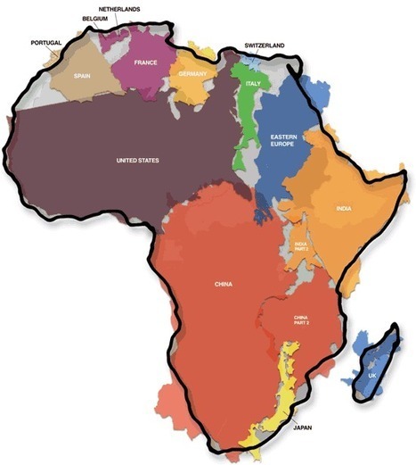
This is another old classic image that I might have shared earlier but it merits repeating. As Salvatore Natoli (a leader in geography education) once said, "In our society we unconsciously equate size with importance and even power." This is one reason why many people have underestimated the true size of Africa relative to places that they view as more important or more powerful.
As we can see, there's a little overlapping here and some empty spots but it's pretty accurate. The United States and China are in the top 5 largest countries of the world list and they still fit in the 2nd largest continent of the world, Africa. I'd like to see the size comparison between Africa and Russia. I did some research on that and it turns out that Russia is a little over half the size of Africa, maybe the size of the combination of the United States and China.
Our planet's magnetic field is in a constant state of change, say researchers who are beginning to understand how it behaves and why.
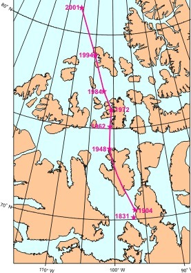
Every few years, scientist Larry Newitt of the Geological Survey of Canada goes hunting. He grabs his gloves, parka, a fancy compass, hops on a plane and flies out over the Canadian arctic. Not much stirs among the scattered islands and sea ice, but Newitt's prey is there--always moving, shifting, elusive. His quarry is Earth's north magnetic pole. Scientists have long known that the magnetic pole moves. James Ross located the pole for the first time in 1831 after an exhausting arctic journey during which his ship got stuck in the ice for four years. No one returned until the next century. In 1904, Roald Amundsen found the pole again and discovered that it had moved--at least 50 km since the days of Ross.
The pole kept going during the 20th century, north at an average speed of 10 km per year, lately accelerating "to 40 km per year," says Newitt. At this rate it will exit North America and reach Siberia in a few decades. Keeping track of the north magnetic pole is Newitt's job. "We usually go out and check its location once every few years," he says. "We'll have to make more trips now that it is moving so quickly." Earth's magnetic field is changing in other ways, too: Compass needles in Africa, for instance, are drifting about 1 degree per decade. And globally the magnetic field has weakened 10% since the 19th century. When this was mentioned by researchers at a recent meeting of the American Geophysical Union, many newspapers carried the story. A typical headline: "Is Earth's magnetic field collapsing?" Probably not. As remarkable as these changes sound, "they're mild compared to what Earth's magnetic field has done in the past," says University of California professor Gary Glatzmaier.
Sometimes the the whole magnetic field of Earth completely flips. The north and the south poles swap places. Such reversals, recorded in the magnetism of ancient rocks, are unpredictable. They come at irregular intervals averaging about 300,000 years; the last one was 780,000 years ago. Are we overdue for another? No one knows.
Earth gains about 40,000 tons of dust every year, the remnants of the formation of the solar system, which are attracted by our gravity and become part of the matter in our planet. In addition, NASA says that Earth gains about 160 tons of matter each year because the global temperature is going up and based on thermodynamics, the global mass has to increase. Earth's core loses energy over time. It's like a giant nuclear reactor that burns fuel. Less energy means less mass. 16 tonnes of that are gone every year. Not much. So why is Earth losing so much mass then?
Here's the big mass loss: about 95,000 tons of hydrogen and 1,600 tons of helium escape Earth every year. They are too light for gravity to keep them around, so they get lost. They just vanish into interplanetary space. The result -- the rough estimate is -50,000 tons of matter lost every year. Which is only about 0.000000000000001% mass loss every year, so it will take trillions of years to deplete all hydrogen from Earth (most is bound in water).
I can kind of see God's hand in this. I think He planned this gain and lost perfectly knowing it would take billions of years for humans lives to be effected.ET
There is evidence that some microbial life had migrated from the Earth’s oceans to land by 2.75 billion years ago, though many scientists believe such land-based life was limited because the ozone layer that shields against ultraviolet radiation did not form until hundreds of millions years later.
But new research from the University of Washington suggests that early microbes might have been widespread on land, producing oxygen and weathering pyrite, an iron sulfide mineral, which released sulfur and molybdenum into the oceans. Sulfur could have been released into sea water by other processes, including volcanic activity. But evidence that molybdenum was being released at the same time suggests that both substances were being liberated as bacteria slowly disintegrated continental rocks. If that is the case, it likely means the land-based microbes were producing oxygen well in advance of what geologists refer to as the “Great Oxidation Event” about 2.4 billion years ago that initiated the oxygen-rich atmosphere that fostered life as we know it. In fact, the added sulfur might have allowed marine microbes to consume methane, which could have set the stage for atmospheric oxygenation. Before that occurred, it is likely large amounts of oxygen were destroyed by reacting with methane that rose from the ocean into the air.
Russian scientists are claiming that a gigantic deposit of industrial diamonds found in a huge Siberian meteorite crater during Soviet times could revolutionize industry.
The Siberian branch of Russian Academy of Sciences said that the Popigai crater in eastern Siberia contains “many trillions of carats” of “impact diamonds” — good for technological purposes, not for jewelry, and far exceeding the currently known global deposits of conventional diamonds.
Nikolai Pokhilenko, the head of the Geological and Mineralogical Institute in Novosibirsk, told RIA Novosti news agency Monday that the diamonds include other molecular forms of carbon. He said they could be twice as hard as conventional diamonds and therefore have superlative industrial qualities.
Pokhilenko said that the diamonds owe their unparalleled hardness to enormous pressure and high temperatures at the moment of explosion when a giant meteorite hit 35 million years ago, leaving a 100-kilometer (60-mile) crater.
The Earth's magnetic field is generated in the fluid outer core by a self-exciting dynamo process. Electrical currents flowing in the slowly moving molten iron generate the magnetic field. In addition to sources in the Earth's core the magnetic field observable at the Earth's surface has sources in the crust and in the ionosphere and magnetosphere. The geomagnetic field varies on a range of scales and a description of these variations is now made, in the order low frequency to high frequency variations, in both the space and time domains. The final section describes how the Earth's magnetic field can be both a tool and a hazard to the modern world.
When a rock is formed it usually acquires a magnetisation parallel to the ambient magnetic field, i.e. the core-generated field. From careful analyses of directions and intensities of rock magnetisation from many sites around the world it has been established that the polarity of the axial dipole has changed many times in the past, with each polarity interval lasting several thousand years. These reversals occur slowly and irregularly, and for a period of about 30 million years around about 100 million years before present, there were no reversals at all. In addition to full reversals there have been many aborted reversals when the magnetic poles are observed to move equatorwards for a while but then move back and align closely with the Earth's spin axis. The solid inner metal core is thought to play an important role in inhibiting reversals. At the present time we are seeing a 6% decline in the dipole moment per century. Whether this is a sign of an imminent reversal is difficult to say.
In 2012, scientists completed a first-ever study with detailed data on the limits of life that thrives deep in the cracks of hot undersea volcanoes, places called hydrothermal vents. The microbes that live in the ocean depths inhale hydrogen and carbon dioxide and exhale methane. There is a tremendous, enormous amount of microbial biomass living within the Earth’s crust in the sediments. Some estimates are that it’s about 1/3 of the total biomass. Others have suggested that it may even rival the biomass that’s living on the surface of the planet.
Astrobiologists think that if there is life in our solar system, say, on Mars, or on Europa, then it’s going to be similar kinds of life. Life that’s independent of sunlight and life that’s independent of oxygen. So by understanding the life and the constraints on the life that lives in these hydrothermal environments, it gives us some idea of what to expect we can expect on these other planets and how we might be able to model this life, using computer models.
Melting of white Arctic ice, currently at its lowest level in recent history, is causing more absorption. Thirty years ago there was typically about eight million square kilometres of ice left in the Arctic in the summer, and by 2007 that had halved, it had gone down to about four million, and this year it has gone down below that. The volume of ice in the summer is only a quarter of what it was 30 years ago and that's really the prelude to this final collapse.
The polar ice cap acts as a giant parasol, reflecting sunlight back into the atmosphere in what is known as the albedo effect. But white ice and snow reflect far more of the sun's energy than the open water that is replacing it as the ice melts. Instead of being reflected away from the Earth, this energy is absorbed, and contributes to warming.
The recent eruption of Iceland's Eyjafjallajökull volcano disrupted air traffic over much of Europe and stranded thousands of passengers across the world. The total cost is estimated to be $5 billion in lost GDP in 2010 alone. But now that dust has cleared, we can see that the eruption was small by historical standards, and there is always the chance of a bigger one: At any given time there are roughly 20 active volcanoes around the world, and there are 16 volcanoes—called "Decade Volcanoes"—that are currently noted to have a history of large eruptions and a proximity to populated areas. Imagine the cost if one of those erupts.
To get content containing either thought or leadership enter:
To get content containing both thought and leadership enter:
To get content containing the expression thought leadership enter:
You can enter several keywords and you can refine them whenever you want. Our suggestion engine uses more signals but entering a few keywords here will rapidly give you great content to curate.


 Your new post is loading...

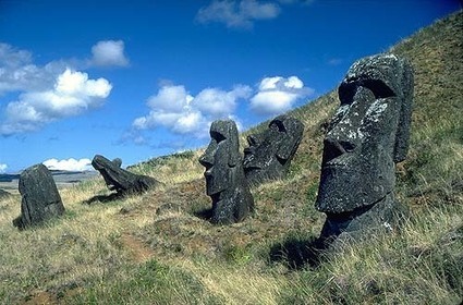


geography article on Australia about how there ecosystem might collapse and become the new Easter island