Your new post is loading...

|
Scooped by
Dr. Stefan Gruenwald
March 26, 2013 11:15 PM
|
Scientists at the University of Georgia have discovered a way to transform carbon dioxide trapped in the atmosphere into useful industrial products, possibly allowing scientists to make biofuels from CO2 in the atmosphere. “Basically, what we have done is create a microorganism that does with carbon dioxide exactly what plants do-absorb it and generate something useful,” said Michael Adams, member of UGA’s Bioenergy Systems Research Institute, Georgia Power professor of biotechnology and Distinguished Research Professor of biochemistry and molecular biology in the Franklin College of Arts and Sciences. “Basically, what we have done is create a microorganism that does with carbon dioxide exactly what plants do-absorb it and generate something useful,” said Michael Adams, member of UGA’s Bioenergy Systems Research Institute, Georgia Power professor of biotechnology and Distinguished Research Professor of biochemistry and molecular biology in the Franklin College of Arts and Sciences. During the process of photosynthesis, plants use sunlight to transform water and carbon dioxide into sugars that the plants use for energy, much like humans burn calories from food. These sugars can be fermented into fuels like ethanol, but it has proven extraordinarily difficult to efficiently extract the sugars, which are locked away inside the plant’s complex cell walls. “What this discovery means is that we can remove plants as the middleman,” said Adams, who is co-author of the study detailing their results published March 25 in the early online edition of the Proceedings of the National Academies of Sciences. “We can take carbon dioxide directly from the atmosphere and turn it into useful products like fuels and chemicals without having to go through the inefficient process of growing plants and extracting sugars from biomass.” The process is made possible by a unique microorganism called Pyrococcus furiosus, or “rushing fireball,” which thrives by feeding on carbohydrates in the super-heated ocean waters near geothermal vents. By manipulating the organism’s genetic material, Adams and his colleagues created a kind of P. furiosus that is capable of feeding at much lower temperatures on carbon dioxide. The research team then used hydrogen gas to create a chemical reaction in the microorganism that incorporates carbon dioxide into 3-hydroxypropionic acid, a common industrial chemical used to make acrylics and many other products. With other genetic manipulations of this new strain of P. furiosus, Adams and his colleagues could create a version that generates a host of other useful industrial products, including fuel, from carbon dioxide. When the fuel created through the P. furiosus process is burned, it releases the same amount of carbon dioxide used to create it, effectively making it carbon neutral, and a much cleaner alternative to gasoline, coal and oil. “This is an important first step that has great promise as an efficient and cost-effective method of producing fuels,” Adams said. “In the future we will refine the process and begin testing it on larger scales.”
|
|
Scooped by
Dr. Stefan Gruenwald
March 13, 2013 3:42 PM
|
In the past 100 years, average temperatures on Earth have changed by 1.3 degrees. Previously, that large of a swing took 5,000 years. That's the word from researchers who pored over temperature data going back to the end of the last ice age. There's plenty of evidence that the climate has warmed up over the past century, and climate scientists know this has happened throughout the history of the planet. But they want to know more about how this warming is different. Now a research team says it has some new answers. It has put together a record of global temperatures going back to the end of the last ice age — about 11,000 years ago — when mammoths and saber-tooth cats roamed the planet. The study confirms that what we're seeing now is unprecedented. What the researchers did is peer into the past. They read ice cores from polar regions that show what temperatures were like over hundreds of thousands of years. But those only reveal changes in those specific regions; cores aren't so good at depicting what happened to the whole planet. Tree rings give a more global record of temperatures, but only back about 2,000 years. Shaun Marcott, a geologist at Oregon State University, says "global temperatures are warmer than about 75 percent of anything we've seen over the last 11,000 years or so." The other way to look at that is, 25 percent of the time since the last ice age, it's been warmer than now. You might think, so what's to worry about? But Marcott says the record shows just how unusual our current warming is. "It's really the rates of change here that's amazing and atypical," he says. Essentially, it's warming up superfast. Here's what happened. After the end of the ice age, the planet got warmer. Then, 5,000 years ago, it started to get cooler — but really slowly. In all, it cooled 1.3 degrees Fahrenheit, up until the last century or so. Then it flipped again — global average temperature shot up. "Temperatures now have gone from that cold period to the warm period in just 100 years," Marcott says. So it's taken just 100 years for the average temperature to change by 1.3 degrees, when it took 5,000 years to do that before. The research team tracked temperature by studying chemicals in the shells of tiny, fossilized sea creatures called foraminifera. Their temperature record matches other techniques that look back 2,000 years, which supports the validity of their much longer record.
|
|
Scooped by
Dr. Stefan Gruenwald
March 11, 2013 11:04 AM
|
Vegetation growth at Earth's northern latitudes increasingly resembles lusher latitudes to the south, according to a NASA-funded study. Vegetation growth at Earth's northern latitudes increasingly resembles lusher latitudes to the south, according to a NASA-funded study based on a 30-year record of land surface and newly improved satellite data sets. Of the 10 million square miles (26 million square kilometers) of northern vegetated lands, 34 to 41 percent showed increases in plant growth (green and blue), 3 to 5 percent showed decreases in plant growth (orange and red), and 51 to 62 percent showed no changes (yellow) over the past 30 years. Satellite data in this visualization are from the AVHRR and MODIS instruments, which contribute to a vegetation index that allows researchers to track changes in plant growth over large areas.
An international team of university and NASA scientists examined the relationship between changes in surface temperature and vegetation growth from 45 degrees north latitude to the Arctic Ocean. Results show temperature and vegetation growth at northern latitudes now resemble those found 4 degrees to 6 degrees of latitude farther south as recently as 1982.
"Higher northern latitudes are getting warmer, Arctic sea ice and the duration of snow cover are diminishing, the growing season is getting longer and plants are growing more," said Ranga Myneni of Boston University's Department of Earth and Environment. "In the north's Arctic and boreal areas, the characteristics of the seasons are changing, leading to great disruptions for plants and related ecosystems."
|
|
Scooped by
Dr. Stefan Gruenwald
March 7, 2013 11:01 AM
|
The world's oldest meteorite crater —a giant impact zone more than 62 miles wide — has been found in Greenland, scientists say. Scientists think it was formed 3 billion years ago by a meteorite 19 miles (30 kilometer) wide — which, if it hit Earth today, would wipe out all higher life. The crater is so wide that it would reach the edge of space 62 miles (100 km) above Earth if stood on end. The crater was "discovered" at an office in Copenhagen by scientist Adam Garde as he pored over maps showing nickel and platinum abundance in the target region of West Greenland. Garde, a senior research scientist with the Geological Survey of Denmark and Greenland, saw a both simple and extreme explanation for several strange geological features in this region: an impact from a meteorite that may have contained valuable metals.
|
|
Scooped by
Dr. Stefan Gruenwald
February 22, 2013 12:10 PM
|
Researchers from Amherst College and The University of Texas at Austin have described a new technique that might one day reveal in higher detail than ever before the composition and characteristics of the deep Earth.
There's just one catch: The technique relies on a fifth force of nature (in addition to gravity, the weak and strong nuclear forces and electromagnetism) that has not yet been detected, but which some particle physicists think might exist. Physicists call this type of force a long-range spin-spin interaction. If it does exist, this exotic new force would connect matter at Earth's surface with matter hundreds or even thousands of kilometers below, deep in Earth's mantle. In other words, the building blocks of atoms—electrons, protons, and neutrons—separated over vast distances would "feel" each other's presence. The way these particles interact could provide new information about the composition and characteristics of the mantle, which is poorly understood because of its inaccessibility.
"The most rewarding and surprising thing about this project was realizing that particle physics could actually be used to study the deep Earth," says Jung-Fu "Afu" Lin, associate professor at The University of Texas at Austin's Jackson School of Geosciences and co-author of the study appearing this week in the journal Science.
This new force could help settle a scientific quandary. When earth scientists have tried to model how factors such as iron concentration and physical and chemical properties of matter vary with depth—for example, using the way earthquake rumbles travel through the Earth or through laboratory experiments designed to mimic the intense temperatures and pressures of the deep Earth—they get different answers. The fifth force, assuming it exists, might help reconcile these conflicting lines of evidence.
Earth's mantle is a thick geological layer sandwiched between the thin outer crust and central core, made up mostly of iron-bearing minerals. The atoms in these minerals and the subatomic particles making up the atoms have a property called spin. Spin can be thought of as an arrow that points in a particular direction. It is thought that Earth's magnetic field causes some of the electrons in these mantle minerals to become slightly spin-polarized, meaning the directions in which they spin are no longer completely random, but have some preferred orientation. These electrons have been dubbed geoelectrons.
|
|
Scooped by
Dr. Stefan Gruenwald
February 20, 2013 10:53 PM
|
In a probable scenario for climate change, New Orleans will no longer exist. Neither will Atlantic City, N.J. Boston will look much like it did in the 17th century, before the city was dredged up to build a port. And Florida will no longer keep its distinct appendage shape. These geographical changes due to sea-level rise are only the beginning, scientists bluntly stated at a briefing yesterday convened by Senate Environment and Public Works Committee Chairwoman Barbara Boxer (D-Calif.). "Today's talk underscored what I already knew, but gives me more facts," said Boxer. "We have to act because our children and our grandchildren need us to act." Storms are likely to travel in different patterns than they did before, much like Superstorm Sandy did. Increasing temperatures are changing the cycles of plants and trees and extending the pollination period to exacerbate allergies. In the hottest cities, it will be uncomfortable to step outside during the day. And limited agricultural growth will severely strain the world's ability to feed itself, said a panel composed of two atmospheric scientists, one public health expert and one biological oceanographer. "The last two years [2011 and 2012] have had the largest number of billion-dollar events," said Donald Wuebbles, a professor of atmospheric sciences at the University of Illinois.
Rising temperatures will increase human exposure to mold, microbial pathogens and infectious diseases, said John Balbus, senior adviser for public health at the National Institute of Environmental Health Sciences. Studies are indicating that the greatest heat-related harm come may not from extreme exposure but rather from the lower but more frequent stress of increasingly hot summer days. "We've seen the geographical range of ticks that cover Lyme disease shift northward, and is predicted to shift further northward in the United States and in Canada," said Balbus, adding that there are limited studies on the actual incidence of Lyme disease. Melting ice is causing heat exchanges between the oceans and the atmosphere that were not possible before, said James McCarthy, a professor of biological oceanography at Harvard University. "Storms like Superstorm Sandy that begin in the tropics and escape the tropics [now] because of the exceptionally warm surface water remain intense until landfall," he said. "When that storm hits, as it did, we have unprecedented potential for disruption."
|
|
Scooped by
Dr. Stefan Gruenwald
February 15, 2013 7:31 PM
|
A meteor that exploded over Russia this morning was the largest recorded object to strike the Earth in more than a century, scientists say. The explosion rivaled a nuclear blast, but the space rock was still too small for existing advance-warning networks to spot. Infrasound data collected by a network designed to watch for nuclear weapons testing suggests that today's blast released hundreds of kilotons of energy. That would make it far more powerful than the nuclear weapon tested by North Korea just days ago and the largest rock crashing on the planet since a meteor broke up over Siberia's Tunguska river in 1908.
"It was a very, very powerful event," says Margaret Campbell-Brown, an astronomer at the University of Western Ontario in London, Canada, who has studied data from two infrasound stations near the impact site. Her calculations show that the meteoroid was approximately 15 meters across when it entered the atmosphere, and put its mass at around 40 tons. "That would make it the biggest object recorded to hit the Earth since Tunguska," she says. The meteor appeared at around 09:25 a.m. local time over the region of Chelyabinsk, near the southern Ural Mountains. The fireball blinded drivers and a subsequent explosion blew out windows and damaged hundreds of buildings. So far, more than 700 people are reported to have been injured, mainly from broken glass, according to a statement from the Russian Emergency Ministry.
|
|
Scooped by
Dr. Stefan Gruenwald
February 8, 2013 11:15 PM
|
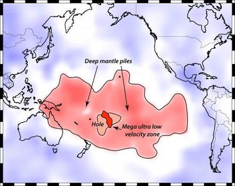
This map shows Earth’s surface superimposed on a depiction of what a new University of Utah study indicates is happening 1,800 miles deep at the boundary between Earth’s warm, rocky mantle and its liquid outer core. Using seismic waves the probe Earth’s deep interior, seismologist Michael Thorne found evidence that two continent-sized piles of rock are colliding as they move atop the core. The merger process isn’t yet complete, so there is a depression or hole between the merging piles. But in that hole, a Florida-sized blob of partly molten rock -- called a “mega ultra low velocity zone” -- is forming from the collision of smaller blobs on the edges of the continent-sized piles. Thorne believe this process is the beginning stage of massive volcanic eruptions that won’t occur for another 100 million to 2100 million years.
|
|
Scooped by
Dr. Stefan Gruenwald
January 28, 2013 7:47 PM
|
Each year, hundreds of millions of metric tons of dust, water, and human-made pollutants make their way into the atmosphere, often traveling between continents on jet streams. Now a new study confirms that some microbes make the trip with them, seeding the skies with billions of bacteria and other organisms—and potentially affecting the weather. What's more, some of these high-flying organisms may actually be able to feed while traveling through the clouds, forming an active ecosystem high above the surface of the Earth. The discovery came about when a team of scientists based at the Georgia Institute of Technology in Atlanta hitched a ride on nine NASA airplane flights aimed at studying hurricanes. Previous studies carried out at the tops of mountains hinted that researchers were likely to find microorganisms at high altitudes, but no one had ever attempted to catalog the microscopic life floating above the oceans—let alone during raging tropical storms. After all, it isn't easy to take air samples while your plane is flying through a hurricane. Despite the technical challenges, the researchers managed to collect thousands upon thousands of airborne microorganisms floating in the troposphere about 10 kilometers over the Caribbean, as well as the continental United States and the coast of California. Studying their genes back on Earth, the scientists counted an average of 5100 bacterial cells per cubic meter of air. Although the researchers also captured various types of fungal cells, the bacteria were over two orders of magnitude more abundant in their samples. Well over 60% of all the microbes collected were still alive. The researchers cataloged a total of 314 different families of bacteria in their samples. Because the type of genetic analysis they used didn't allow them to identify precise species, it's not clear if any of the bugs they found are pathogens. Still, the scientists offer the somewhat reassuring news that bacteria associated with human and animal feces only showed up in the air samples taken after Hurricanes Karl and Earl. In fact, these storms seemed to kick up a wide variety of microbes, especially from populated areas, that don't normally make it to the troposphere. Although many of the organisms borne aloft are likely occasional visitors to the upper troposphere, 17 types of bacteria turned up in every sample. Researchers like environmental microbiologist and co-author Kostas Konstantinidis suspect that these microbes may have evolved to survive for weeks in the sky, perhaps as a way to travel from place to place and spread their genes across the globe. "Not everybody makes it up there," he says. "It's only a few that have something unique about their cells" that allows them survive the trip.
|
|
Scooped by
Dr. Stefan Gruenwald
January 27, 2013 10:44 PM
|
Researchers believe that ancient archaea, similar in shape to this Halobacteria, used aerobic respiration 2.9 billion years ago to produce an active form of vitamin B6 Billions of years ago, a tiny, single-celled organism started using oxygen. It is not exactly known when this happened, or why, but a team of scientists has come closer than ever before to finding that out. They have identified the earliest known example of an aerobic metabolism, the process of using oxygen as fuel. The discovery may even provide clues as to where the oxygen came from in the first place. To travel so far back in time, evolutionary bioinformaticist Gustavo Caetano-Anollés of the University of Illinois, Urbana-Champaign, along with colleagues in China and South Korea, did a bit of molecular sleuthing. They scoured published genomes from all groups of organisms-although they didn't include viruses in this study-focusing on pieces of proteins known as domains. These pieces have their own distinguishing shapes that provide clues to the protein's function and can be categorized based on various characteristics. Just like a Victorian house has certain features that set it apart from a Tudor mansion, researchers can tell the difference between different domains based on their shape. The team produced a kind of molecular clock by establishing an evolutionary sequence for single-domain proteins. Caetano-Anollés and his colleagues could then tie that sequence to the geologic timeline. By correlating the appearance of domains integral to events such as the rise of eukaryotes, organisms with membrane-bound cellular structures, they could determine an approximate date for the origin of particular domains. "Molecular clocks aren't perfect," Caetano-Anollés acknowledges. "And sometimes they misbehave. But the [domains] that we sampled that were linked to clear-cut events had good agreement." The researchers found that the most ancient aerobic process was the production of pyridoxal, or the active form of vitamin B6, they report today in Structure. This reaction appeared about 2.9 billion years ago, along with an oxygen-producing enzyme called manganese catalase. This enzyme detoxifies hydrogen peroxide by breaking it down into water and oxygen. Caetano-Anollés hypothesizes that early organisms got the oxygen they needed to produce vitamin B6 from this breakup of hydrogen peroxide. The authors argue that these ancient organisms would have encountered massive amounts of hydrogen peroxide in their environment due to the bombardment of glacial ice by ultraviolet radiation, which can generate the compound.
|
|
Scooped by
Dr. Stefan Gruenwald
January 22, 2013 8:42 PM
|
An unusual event playing out high in the atmosphere above the Arctic Circle is setting the stage for what could be weeks upon weeks of frigid cold across wide swaths of the U.S. When the sudden stratospheric warming event began in early January, that signaled to weather forecasters that a cool down was more likely to occur by the end of the month, since it usually takes many days for developments in the stratosphere to affect weather in the troposphere, and vice versa. As the polar stratosphere warms, high pressure builds over the Arctic, causing the polar jet stream to weaken. At the same time, the midlatitude jet stream strengthens, while also becoming wavier, with deeper troughs and ridges corresponding to more intense storms and high pressure areas. In fact, sudden stratospheric warming events even make so-called “blocked” weather patterns more likely to occur, which tilts the odds in favor of the development of winter storms in the U.S. and Europe. The graph shows the evolution of the stratospheric warming event. The contours show absolute heights and the shading are height anomalies in the middle stratosphere, or about 16 miles above the surface. The height anomalies are a good proxy for temperature anomalies in the stratosphere with red representing high heights or warm temperatures and blue low heights or cold temperatures. You can see at the beginning of the loop a cohesive polar vortex along the coast of Northern Eurasia and then this area of higher heights or warm temperaturs rush poleward from Siberia into the polar vortex splitting it into two pieces, one over Eurasia and one over North America. The dramatic rise in heights or temperatures over the Pole is the sudden stratospheric warming. The result is that pieces of the polar vortex move equatorward and with it the associated cold temperatures. Usually something similar occurs in the troposphere in the ensuing weeks.
|
|
Scooped by
Dr. Stefan Gruenwald
January 5, 2013 1:28 PM
|
For centuries people have tried to predict earthquakes-with no success. Magnetic signals from rocks deep inside the earth are the latest prospect. The dream is to be able to forecast earthquakes like we now predict the weather. Even a few minutes' warning would be enough for people to move away from walls or ceilings that might collapse or for nuclear plants and other critical facilities to be shut down safely in advance of the temblor. And if accurate predictions could be made a few days in advance, any necessary evacuations could be planned, much as is done today for hurricanes. Scientists first turned to seismology as a predictive tool, hoping to find patterns of foreshocks that might indicate that a fault is about to slip. But nobody has been able to reliably distinguish between the waves of energy that herald a great earthquake and harmless rumblings. Seismologists just can't give a simple yes or no answer to the question of whether we're about to have a large earthquake, said Thomas Jordan, director of the University of Southern California's Southern California Earthquake Center at a meeting of the American Geophysical Union (AGU) in San Francisco in December. So some scientist have turned their attention to other signals, including electricity, that might be related to activity occurring below ground as a fault prepares to slip One theory is that when an earthquake looms, the rock "goes through a strange change," producing intense electrical currents, says Tom Bleier, a satellite engineer with QuakeFinder, a project funded by his parent company, Stellar Solutions, of Cambridge, Massachusetts. "These currents are huge," Bleier said at the AGU meeting. "They're on the order of 100,000 amperes for a magnitude 6 earthquake and a million amperes for a magnitude 7. It's almost like lightning, underground."
|
|
Rescooped by
Dr. Stefan Gruenwald
from Science News
December 4, 2012 11:07 AM
|
Hoping to expand our understanding of auroras and other fleeting atmospheric events, a team of space-weather researchers designed and built NORUSCA II, a new camera with unprecedented capabilities that can simultaneously image multiple spectral bands, in essence different wavelengths or colors, of light. The camera was tested at the Kjell Henriksen Observatory (KHO) in Svalbard, Norway, where it produced the first-ever hyperspectral images of auroras—commonly referred to as "the Northern (or Southern) Lights"—and may already have revealed a previously unknown atmospheric phenomenon.
Via Sakis Koukouvis
|
|
|
Scooped by
Dr. Stefan Gruenwald
March 18, 2013 12:17 PM
|
Scientists have long known that veins of gold are formed by mineral deposition from hot fluids flowing through cracks deep in Earth’s crust. But a study published today in Nature Geoscience has found that the process can occur almost instantaneously — possibly within a few tenths of a second. The process takes place along 'fault jogs' — sideways zigzag cracks that connect the main fault lines in rock, says first author Dion Weatherley, a seismologist at the University of Queensland in Brisbane, Australia. When an earthquake hits, the sides of the main fault lines slip along the direction of the fault, rubbing against each other. But the fault jogs simply open up. Weatherley and his co-author, geochemist Richard Henley at the Australian National University in Canberra, wondered what happens to fluids circulating through these fault jogs at the time of the earthquake. What their calculations revealed was stunning: a rapid depressurization that sees the normal high-pressure conditions deep within Earth drop to pressures close to those we experience at the surface. For example, a magnitude-4 earthquake at a depth of 11 kilometres would cause the pressure in a suddenly opening fault jog to drop from 290 megapascals (MPa) to 0.2 MPa. (By comparison, air pressure at sea level is 0.1 MPa.) “So you’re looking at a 1,000-fold reduction in pressure,” Weatherley says. Big earthquakes will produce bigger pressure drops, but for gold-vein formation, that seems to be overkill. More interesting, Weatherley and Henley found, is that even small earthquakes produce surprisingly big pressure drops along fault jogs. “We went all the way to magnitude –2,” Weatherley says — an earthquake so small, he adds, that it involves a slip of only about 130 micrometres along a mere 90 centimetres of the fault zone. “You still get a pressure drop of 50%,” he notes.
That, Weatherley adds, might be one of the reasons that the rocks in gold-bearing quartz deposits are often marbled with a spider web of tiny gold veins. “You [can] have thousands to hundreds of thousands of small earthquakes per year in a single fault system,” he says. “Over the course of hundreds of thousands of years, you have the potential to precipitate very large quantities of gold. Small bits add up.” Weatherley says that prospectors might be able to use remote sensing techniques to find new gold deposits in deeply buried rocks in which fault jogs are common. “Fault systems with lots of jogs can be places where gold can be distributed,” he explains. But Taka’aki Taira, a seismologist at the University of California, Berkeley, thinks that the finding might have even more scientific value. That’s because, in addition to showing how quartz deposits might form in fault jogs, the study reveals how fluid pressure in the jogs rebounds to its original level — something that could affect how much the ground moves after the initial earthquake.
|
|
Scooped by
Dr. Stefan Gruenwald
March 12, 2013 1:45 AM
|
There are many bizarre things in Australia, but few go even close to the pink lake Hillier.
Lake Hillier is a pink-coloured lake on Middle Island in Western Australia – the largest island from the Recherche Archipelago, a group of about 105 islands. A narrow strip of land composed of sand dunes covered by vegetation separates it from the ocean. The tiny lake only spans 600 meters wide, but the pink color is just unmistakable – and downright weird. What you’re seeing around it is a ime of white salt and a dense woodland of Paperbark and Eucalypt trees. The first reported sighting dates back to the journals of Matthew Flinders, a British navigator and hydrographer in 1802. Nobody knows exactly why it’s pink! The flamboyant rose pink color does not alter when you take the water and put it into a container, and many biologists believe this is all caused by a combination of low nutrient concentrations and bacteria (Dunaliella salina & Halobacterium, to be more precise).
|
|
Scooped by
Dr. Stefan Gruenwald
March 7, 2013 11:05 AM
|
Deep in water-filled underground caves beneath Australia's Nullarbor Plain, cave divers have discovered unusual 'curtains' of biological material – known as Nullarbor cave slimes. An unusual combination of microbes thrive in the Weebubbie caves. "Earlier studies on the community suggested that there was an unusual chemistry going on in the caves, but we didn't know how the microbes were making a living in the cave environment," says the lead scientist Professor Ian Paulsen, Macquarie University. In order to find this 'missing link', the team of researchers made use of a range of new technologies, such next-generation sequencing of environmental DNA and scanning electron microscopy to take an in-depth look at the composition of the Weebubbie cave slime community. This approach detected a dominant group of organisms in the cave slimes, known as the Thaumarchaeota. This community of microbes thrives in the total dark, independent of photosynthesis. It is thought that the periodic inundations of the Nullarbor caves by the sea occurred a number of times in the geological past and so researchers suggest that the Weebubbie Thaumarchaeota may have a marine origin. "We know that the Nullarbor Plain's karst system arose from the sea in the Middle Miocene period and so this may be a clue as to where the Weebubbie Thaumarchaeota came from," says Professor Paulsen The research team says this analysis shows that the organisms make up the Weebubbie cave slime community make their living in a very unusual way – by oxidizing ammonia in the salty cave water – and are completely independent of sunlight and ecosystems on the surface. "It just goes to show that life in the dark recesses of the planet comes in many strange forms, many of which are still unknown," says Professor Paulsen.
|
|
Scooped by
Dr. Stefan Gruenwald
March 4, 2013 5:33 PM
|
The Great Oxidation Event occured around 2.3 billion years ago, when it was no longer possible for newly created oxygen to be captured in chemical compounds. Instead, it started to accumulate as oxygen in the oceans and in the atmosphere. Before this event, in the Earth's early atmosphere, there were only traces of free oxygen. All life was based exclusively on anaerobic processes - chemical reactions that did not require oxygen. With the emergence of cyanobacteria that oxidized water with the help of light and produced oxygen as a by-product, the conditions for life on Earth gradually began to transform. New research by scientists at the University of Bristol and Boston University suggests that the evolution of multicellularity coincided with increased diversification of cyanobacteria and the Great Oxidation Event. Cyanobacteria are among the most diverse prokaryotic phyla, with morphotypes ranging from unicellular to multicellular filamentous forms, including those able to irreversibly differentiate in form and function. It has been suggested that cyanobacteria raised oxygen levels in the atmosphere around 2.45–2.32 billion years ago during the Great Oxidation Event and dramatically changing life on the planet. However, little is known about the possible interplay between the origin of multicellularity, diversification of cyanobacteria, and the rise of atmospheric oxygen. The team tested whether the evolution of multicellularity overlapped with the Great Oxidation, and whether multicellularity is associated with significant shifts in diversification rates in cyanobacteria. The results indicate an origin of cyanobacteria before the rise of atmospheric oxygen. The evolution of multicellular forms coincided with the onset of the Great Oxidation Event and an increase in diversification rates, suggesting that multicellularity could have played a key role in triggering cyanobacterial evolution. In prior studies, geochemists challenged the simple notion of an up-only trend for early oxygen and provided the first compelling direct evidence for a major drop in oxygen after The Great Oxidation event some, which was critical for the origin and evolution of the first forms of eukaryotic life. The second big step in the up-only hypothesis occurred almost two billion years later, coinciding with the first appearances and earliest diversification of animals.
|
|
Scooped by
Dr. Stefan Gruenwald
February 21, 2013 3:04 PM
|
The meteorite on February 14th weighed about 10,000 tons. According to NASA, the power released during the explosion was equivalent to 500 kiloton, which is 30 times the power of the bomb that destroyed Hiroshima. NASA experts describe the Chebarkul meteorite as the second largest since 1908, when a meteor hit Tunguska in Siberia. Such a meteor strike can be expected every 100 years, a NASA expert said. Chelyabinsk meteorite fragments are already on sale on one of the most popular online auctions, Ebay. Not only the citizens of Russia are among the vendors but also Americans are involved. Astronomers could not trace the Chelyabinsk meteor because this celestial body was approaching from the Sun, and telescopes did not see it in the sunshine, Deputy Director of the Sternberg Astronomical Institute at the Moscow State University Sergei Lamzin said. "It was impossible to detect it, because it was flying fromthe Sun. But if it was flying at night, our MASTER telescopes’network could have traced it", Lamzin said to journalists. MASTER telescopes can observe bursts in the Universe, watch comets, meteors and space debris. The system includes telescopes, located in the Tunka valley, Moscow region, Kislovodsk, in the Urals and in Blagoveschensk. In the period of time around the fall of the Chelyabinsk meteor, the Russian Meteor weather satellite registered an increase in the concentration of water molecules in the orbit that possibly indicates that the space "guest" was a comet. Researchers say the meteorite exploded into at least seven large pieces and hundreds of small ones. One of the bigger fragments plunged into the local Chebarkul Lake, forming an 8-meter ice hole. REPORT is here: http://tinyurl.com/b8tbrkh
|
|
Scooped by
Dr. Stefan Gruenwald
February 18, 2013 8:29 PM
|
An asteroid half the size of a football field passed closer to Earth than any other known object of its size on Friday, the same day an unrelated and much smaller space rock blazed over central Russia, creating shock waves that shattered windows and injured 1,200 people.
Asteroid 2012 DA14, discovered just last year, passed about 17,200 miles from Earth at 2:25 p.m. EST (1925 GMT), closer than the networks of television and weather satellites that ring the planet. "It's like a shooting gallery here. We have two rare events of near-Earth objects approaching the Earth on the same day," NASA scientist Paul Chodas said during a webcast showing live images of the asteroid from a telescope in Australia. Scientists said the two events, both rare, are not related -the body that exploded over Chelyabinsk, Russia, at 10:20 p.m. EST Thursday (0320 GMT Friday) came from a different direction and different speed than DA14. "It's simply a coincidence," Chodas said. NASA has been tasked by the U.S. Congress to find and track all near-Earth objects that are .62 miles in diameter or larger. The effort is intended to give scientists and engineers as much time as possible to learn if an asteroid or comet is on a collision course with Earth, in hopes of sending up a spacecraft or taking other measures to avert catastrophe. About 66 million years ago, an object 6 miles in diameter smashed into what is now the Yucatan Peninsula in Mexico, leading to the demise of the dinosaurs, as well as most plant and animal life on Earth. Scientists estimate that only about 10 percent of smaller objects, such as DA14, have been found. "Things that are that tiny are very hard to see. Their orbits are very close to that of the Earth," said Paul Dimotakis, a professor of aeronautics and applied physics at the California Institute of Technology in Pasadena.
|
|
Scooped by
Dr. Stefan Gruenwald
February 8, 2013 11:26 PM
|
ESA Observing the Earth homepage, features the latest news on Earth observation missions and satellites, including ERS 1, ERS 2, Envisat, Metop, Meteosat and Living Planet. Satellites show that the recent ozone hole over Antarctica was the smallest seen in the past decade. Long-term observations also reveal that Earth’s ozone has been strengthening following international agreements to protect this vital layer of the atmosphere. According to the ozone sensor on Europe’s MetOp weather satellite, the hole over Antarctica in 2012 was the smallest in the last 10 years. The instrument continues the long-term monitoring of atmospheric ozone started by its predecessors on the ERS-2 and Envisat satellites. Since the beginning of the 1980s, an ozone hole has developed over Antarctica during the southern spring – September to November – resulting in a decrease in ozone concentration of up to 70%. Ozone depletion is more extreme in Antarctica than at the North Pole because high wind speeds cause a fast-rotating vortex of cold air, leading to extremely low temperatures. Under these conditions, human-made chlorofluorocarbons – CFCs – have a stronger effect on the ozone, depleting it and creating the infamous hole. Over the Arctic, the effect is far less pronounced because the northern hemisphere’s irregular landmasses and mountains normally prevent the build-up of strong circumpolar winds. To understand these complex processes better, scientists rely on a long time series of data derived from observations and on results from numerical simulations based on complex atmospheric models. Although ozone has been observed over several decades with multiple instruments, combining the existing observations from many different sensors to produce consistent and homogeneous data suitable for scientific analysis is a difficult task. Within the ESA Climate Change Initiative, harmonised ozone climate data records are generated to document the variability of ozone changes better at different scales in space and time. With this information, scientists can better estimate the timing of the ozone layer recovery, and in particular the closure of the ozone hole. Chemistry climate models show that the ozone layer may be building up, and the hole over Antarctica will close in the next decades.
|
|
Scooped by
Dr. Stefan Gruenwald
February 7, 2013 2:24 AM
|
The hole in the Antarctic ozone layer has caused changes in the way that waters in the southern oceans mix, an international study shows. A team of scientists led by Professor Darryn Waugh ofJohns Hopkins University, has found that waters originating at the surface at sub-tropical latitudes is mixing into the deeper ocean at a much higher rate than it did 20 years ago, and the reverse is true for waters closer to Antarctica.
|
|
Scooped by
Dr. Stefan Gruenwald
January 28, 2013 6:53 PM
|
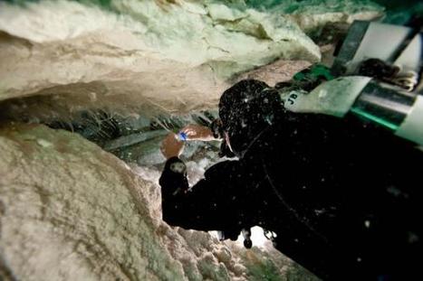
Scientists have peered for the first time into the interior of a lake hidden beneath the Antarctic ice sheet. Subglacial Lake Whillans, located less than 400 miles from the South Pole, had sat isolated under the ice for hundreds of thousands of years—perhaps up to a million years. But over the last week a team of ice drillers has used a jet of hot water to melt a narrow hole into the lake through 2,600 feet of ice. Final confirmation that the lake had been reached unfolded inside a steel shipping container parked on the ice sheet on four massive skis. Seventeen people crowded into this mobile control room as a video camera was lowered into the borehole. All eyes were riveted to a computer monitor. A scene reminiscent of cosmic wormhole travel unfolded on it: the camera steered into the black void at the center of the screen; the smooth, round, undulating walls of ice-hole scrolled by on the edges. Billowing clouds obscured the camera’s view in the lower reaches of the hole. Then, as the swirling silt settled, a fuzzy picture emerged: the camera lay on its side, its lens looking across a muddy brown bottom strewn with small rocks. Wisps of mud drifted above. The image, knitted in rows of grainy pixels, echoed the first pictures of the Martian surface, radioed back by the Viking lander almost 40 years ago. The door of the control room opened and in stepped a woman covered head to ankle in a sterile white Tyvek suit—Jill Mikucki, a microbiologist from the University of Tennessee in Knoxville who had helped lower the camera into the lake. Mikucki pointed her own little Canon at the image on the computer monitor and tried to snap a photo—“Oh,” she murmured, disappointed: the cold had killed her batteries. She paused. “It’s beautiful,” she said, forced to appreciate it in the moment—“really beautiful”—then she hurried out to help retrieve the camera.
|
|
Scooped by
Dr. Stefan Gruenwald
January 25, 2013 11:30 AM
|
Greenland was about eight degrees warmer 130,000 years ago than it is today, an analysis of an almost three-kilometer-long ice core in Greenland has revealed. It is important to understand what happened in Greenland during the Eemian period because the temperatures experienced then are "within the realms of where we are heading", says Etheridge. However, he says the previous warming was due to the Earth receiving more of the Sun's radiation due to its orbit at the time, while today's warming is being driven by increases in greenhouse gases in the atmosphere. The study also shows sea levels were on average 6 meters higher. The results provide "important benchmarks for future climate change projections" in temperature and the contribution of the two main ice sheets to sea level rises, Rubino says. He says the study also reveals the Greenland ice sheet did not melt as much as previously thought so was not the major contributor to sea level at that time. "It shows the major contribution to sea level rises was not coming from the Greenland ice shelf," he says. "It was previously believed that Greenland melted entirely during the Eemian, but in fact the ice sheet was not that much different from what it is now."
|
|
Scooped by
Dr. Stefan Gruenwald
January 7, 2013 11:22 AM
|
The deadliest hurricane in the period since 1851 hit Texas in 1900 and claimed 8,000 lives. Hurricane Sandy, which struck the U.S. in October 2012, is estimated to have caused upward of 110 fatalities in the U.S. and $50 billion in damage (in 2012 dollars). The deadliest hurricane to strike the United States since 1851 was the Galveston, Texas hurricane of Sept. 1900. The category 4 storm claimed 8,000 lives by most reports, although the true toll may have been as high as 12,000. The costliest hurricane was the 1926 category 4 storm that hit southeast Florida in 1926. The unnamed storm caused $165 billion in damage (in 2005 dollars). By comparison, 2005’s hurricane Katrina had the third-highest death toll, killing 1,200. Katrina was the second costliest hurricane, with $113 billion in damage (2005 dollars). Another extremely costly hurricane was 1992’s Andrew, which did $59 billion worth of damage in southeast Florida and Louisiana. The practice of giving storms names became widespread in World War II. Initially, only female names were used, but since 1979, storms have been given both male and female names. Damage amounts and death tolls are from an August, 2011 study by NOAA entitled “The Deadliest, Costliest, and Most Intense United States Tropical Cyclones from 1851 to 2010 (and Other Frequently Requested Hurricane Facts.”
|
|
Scooped by
Dr. Stefan Gruenwald
January 4, 2013 1:33 PM
|
By considering the unique sea-level "fingerprint" created by a melting ice sheet, a team of geophysicists in North America has developed a new method for pinpointing the sources of global sea-level rise. Their approach could provide a way to measure the impact of the Greenland and West Antarctic ice sheets – the greatest sources of uncertainty in projections of future sea-level changes. Long-term variations in sea level are caused by processes including thermal expansion of the water, changes in ocean circulation, and changes in the size of glaciers and ice sheets. Measurements from tide gauges indicate a global average sea-level rise of 1–2 mm/yr during the 20th century. However, this estimate ignores geographical variations in sea level, and provides no information about the contribution of different processes. One possible way to pick apart the total sea-level change is to look for the distinct pattern, or fingerprint, of a melting ice sheet. Close to the ice sheet, for example, the sea level tends to fall. This is a result of both the local uplift of the Earth's crust after being relieved of the great weight of the ice and a reduction in the ice sheet's gravitational pull on the ocean. Moving further away from the ice sheet, however, the sea level rises progressively. Melt rates of 0.3 and 0.5 mm/yr were assumed for the Greenland (GIS) and West Antarctic (WAIS) ice sheets, respectively, along with their predicted fingerprints. The researchers then applied the Kalman filter to this synthetic dataset, initializing the algorithm with melt rates of zero. The algorithm was found to estimate the melt rates most accurately when applied to the maximum number of tide gauges, providing enough information for the ice-sheet fingerprints to be separated from the globally uniform trend. The final estimated melt rates for the GIS and WAIS were 0.21 and 0.38 mm/yr, respectively, close to the values used in the synthetic dataset. The 1σ uncertainties associated with these values indicate the magnitude of ice-sheet melting that could potentially be detected in real sea-level records.
|