

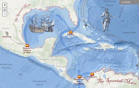

Explore the travels and exploits of five real pirates of the Caribbean. Click through the tabs to track the adventures of each pirate overlaid on Spanish ports and pirate strongholds in the area. Zoom into the map to see additional detail.
Get Started for FREE
Sign up with Facebook Sign up with X
I don't have a Facebook or a X account


 Your new post is loading... Your new post is loading...
Explore the travels and exploits of five real pirates of the Caribbean. Click through the tabs to track the adventures of each pirate overlaid on Spanish ports and pirate strongholds in the area. Zoom into the map to see additional detail.
Seth Dixon's insight:
This interactive StoryMap is great way to show the historical and geographic context of colonial-era piracy in the Caribbean.
Tags: Middle America, ESRI, mapping, historical. 
|
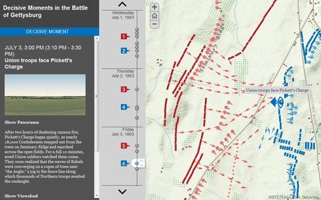
"GIS has given us the chance to re-examine how the Civil War battle was won and lost."
Seth Dixon's insight:
July 1-3 mark the 150th anniversary of the Battle of Gettysburg, and it seems only appropriate to share these rich, interactive resources to commemorate the event (this particular interactive feature uses an ESRI storymap template). This fantastic example from the Smithsonian Magazine shows how history teaching and research can be benefited by using GIS with the example of Gettysburg. Many student today visit the sites of the Battle of Gettysburg and get a greater appreciation of battle by getting a sense of the lay of the land and the challenged confronting both armies. National Geographic has additionally put together resources to made out other Civil War battles. GIS is not a tool that is just for geographers; any analysis that requires spatial analysis can be mapped.

Todd Pollard's curator insight,
February 4, 2014 10:34 PM
I really like this interactive map application. 
Rich Schultz's curator insight,
November 18, 2014 3:14 PM
Just another of the millions of uses for GIS... |


This pirate excursion map is so cool and gives a great look at the travels of different pirates. As we get farther away from these time periods, it seems like the idea of these Caribbean pirates are fictional. To hear true historical events about these individual pirates is very interesting. I would love to take a time machine back to Port Royal during these times to experience that madness.
Imagine the horror a native of the Caribbean must have felt when white men came into their scenic lands and pillaged their villages and plundered their treasuries? Blackbeard otherwise known as Edward Teach, would light slow burning cannon fuses and place them in his beard to create an aura about him as he fought and raided these port of call. Calico Jack Rackham, a great pirate name if there ever was one, was best known for having a pair of female pirates aboard. Instantly becomes one of my heroes! Then you have William Parker who was actually an opportunist backed by England who plundered Spanish treasures throughout Central America. Here is my favorite pirate joke; what is a pirate's favorite letter? "R" you say? No, it's the letter "C", pirates love the sea....
very interesting interactive map