


"GIS has given us the chance to re-examine how the Civil War battle was won and lost."
Get Started for FREE
Sign up with Facebook Sign up with X
I don't have a Facebook or a X account


 Your new post is loading... Your new post is loading...
"GIS has given us the chance to re-examine how the Civil War battle was won and lost."
Seth Dixon's insight:
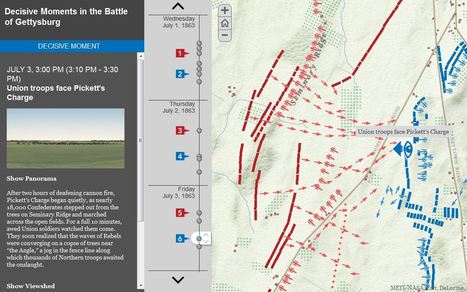
July 1-3 mark the 150th anniversary of the Battle of Gettysburg, and it seems only appropriate to share these rich, interactive resources to commemorate the event (this particular interactive feature uses an ESRI storymap template). This fantastic example from the Smithsonian Magazine shows how history teaching and research can be benefited by using GIS with the example of Gettysburg. Many student today visit the sites of the Battle of Gettysburg and get a greater appreciation of battle by getting a sense of the lay of the land and the challenged confronting both armies. National Geographic has additionally put together resources to made out other Civil War battles. GIS is not a tool that is just for geographers; any analysis that requires spatial analysis can be mapped. 
|
This is a video introduction to www.historypin.com which might just prove to be a very useful and important project. It's historical geography powered by collaborative mapping that is infused with social media dynamics. Backed by Google, they are geo-tagging old photos to recreate the historical geographies of all places and comparing them with current street view images. You can search by topic, place or date...this has the potential to be very big.
|


I really like this interactive map application.
unit 1
Just another of the millions of uses for GIS...