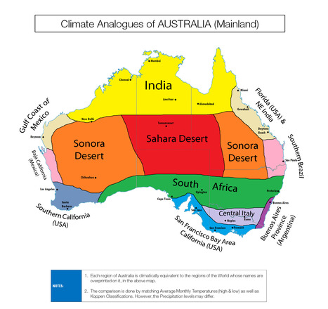

"Triton1982 makes maps by comparing each of the city's highest and lowest average temperatures against the Koppen classification system."
Get Started for FREE
Sign up with Facebook Sign up with X
I don't have a Facebook or a X account


 Your new post is loading...
 Your new post is loading...
Your new post is loading...
"Triton1982 makes maps by comparing each of the city's highest and lowest average temperatures against the Koppen classification system." 

Kelsey McIntosh's curator insight,
May 3, 2018 10:23 PM
This is an interesting map that compares Australia's climate to that of other regions. By doing this, the artist clearly explains how vast Australia's climate truly is. Because of its size, it is possible to think that Australia would not have such a diverse climate. However, its regions are comparable to deserts, the tropics, and temperate zones.

Matt Danielson's curator insight,
December 12, 2018 4:30 PM
I found this very interesting. I always imagined Australia as a temperate cost with a vast dessert/prairie interior that was generally inhospitable. Though the interior part is true I learned that the coastal areas vary greatly in climate. This allows for a much more varied ecosystem in Australia than I ever imagined.

Corey Rogers's curator insight,
December 15, 2018 8:39 PM
This map makes it easier to understand the climate that is inside Australia. It is cool how every part of the country has its own unique climate. It also shows just how big Australia is and how crazy their climate can be.
Sign up to comment

See where 11,967 cyclones overlap in space in this fascinating look at the planet's most powerful storms. The gusty cartography plots the paths all the tropical cyclones recorded in the past 170 years. Brighter areas show where they have overlapped in space, representing areas of historically frequent hurricane activity. Via Lauren Moss
|
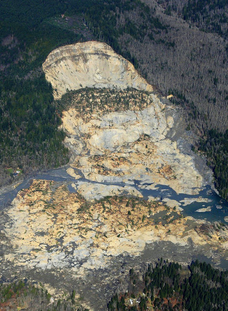
Human contribution to geomorpoloogical hazardsIn recent decades the state allowed logging — with restrictions — on the plateau above the Snohomish County hillside that collapsed in last weekend’s deadly mudslide.

Geofreak's curator insight,
April 3, 2014 1:39 PM
Mijnbouw en aardverschuivingen, een goede combinatie ...... 
PIRatE Lab's curator insight,
April 7, 2014 11:48 AM
There are several reasons for mudslides--some are purely a result of physical geography and others are related to land use patterns. This last week's mudslide in Washington state was a combination of the two and although this impacts one place (see on map), it is a good teaching moment to discuss the environmental impacts of land use patterns and resource extraction projects. As seen in this interactive, the river was cutting at the base of the hill, while loggers were clear-cutting at the top of the mountain. Trees help prevent erosion as the roots hold the soil in place--a critical piece to the puzzle in a very rainy climate. With $1 million worth of timber on the slope, logging companies persisted despite objections from the Department of Natural Resources and some restrictions (but in hindsight, those restrictions clearly were not enough).
View the impact in ArcGIS online: Before and After Swipe, LiDAR I and II, and Imagery.
Questions to Consider: Other than economic worth, what other ways are there to value and evaluate the environment? How could this landscape have been protected and managed better or was this mudslide inevitable? 
El Futuro deWaukesha's curator insight,
April 18, 2014 12:03 AM
Working on an Inquiry of recent natural disasters with first grader.

Paul Nicoara's curator insight,
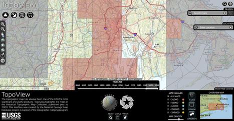
May 5, 2013 5:05 PM
The National Geologic Map Database is a simple interactive tool to find USGS topographic maps that you can dowload. Users can search for current or historic maps. |