Secondo giorno della visita ufficiale alle Isole Solomon...


 Your new post is loading...
 Scoop.it! Secondo giorno della visita ufficiale alle Isole Solomon... 
No comment yet.
Sign up to comment
Scoop.it!

Art - community of artists and those devoted to art. Digital art, skin art, themes, wallpaper art, traditional art, photography, poetry / prose. Art prints. Via Jimi Paradise
Scoop.it!

Lisandra Aguila Rico, 21 anni, era stata fermata in Campania
Scoop.it!

Momenti di panico nella metropolitana di Madrid catturati da una delle telecamere di sorveglianza: un uomo cade sui binari della metropolitana e batte la testa, forse perde conoscenza, proprio mentre il treno si sta avvicinando alla stazione.
Scoop.it!

La discesa in campo di Matteo Renzi e lo stile mutuato dalla tv: il sindaco di Firenze rinnova il palinsesto del centrosinistra...
Scoop.it!

Il 36% appoggerà un partito tradizionale. Il consenso per Bersani supera di poco il 50% tra gli elettori pd, ma non conquista la maggioranza nel centrosinistra.
Scoop.it!

Seconda sconfitta consecutiva in casa per i rossoneri, apparsi lenti e senza qualità.
Scoop.it!

"One of the best things about using an iPad is the great apps that we can run on it. There are excellent apps for just about any purpose you can think of.
This week’s pick is Hobbit Movies, the official companion app for the The Hobbit: An Unexpected Journey – the upcoming Peter Jackson directed movie that continues his series bringing Tolkien classics to the big screen. This is the first of a trilogy of films from Jackson adapting Tolkien’s The Hobbit." Via John Evans
Scoop.it!
John Lennon and Paul McCartney singing a duet "Ain't That a Shame" http://www.youtube.com/watch?v=yxRFdJyZg1k
Follow Me On Google Plus https://plus.google.com/115285805034937175151/posts
Follow Me On Twitter https://twitter.com/krazyfella
Home of our Hearts-Cape Breton http://pinterest.com/krazyfella/home-of-our-hearts-cape-breton-nova-scotia/
Scoop.it!

OggiNotizieGossip - Nicole Minetti testimonial del Fatebenefratelli?
Scoop.it!
Gossip/ Balotelli, una super Porsche per il fratello EnockVirgilioMilano, 15 set. (TMNews) - L'ultima "follia" di Mario Balotelli è un'auto nuova, non per lui, ma per il fratello.
|
Scoop.it!

«L'Italia sta facendo bene. Sugli aiuti decida da sola».
Scoop.it!

Atteso un calo delle vendite a causa della debolezza del mercato italiano.
Scoop.it!

La presidente: «Alla Regione Lazio catastrofe come alluvione di Firenze».
Scoop.it!

Il pedaggio ritorna, con alcune novità, dopo la sospensione decisa dal Consiglio di Stato...
Scoop.it!

La messa sulla spiaggia di Beirut davanti a 500 mila persone: «I cristiani collaborino con tutte le persone di buona volontà»...
Scoop.it!

Il segretario del Pdl: «Sostegno alla Polverini per finanziamenti trasparenti alla Regione Lazio»...
Scoop.it!

Fornero: «Ho chiesto un incontro a Marchionne» Bersani: «Spettacolo poco simpatico» Alfano: «Abbandono sarebbe cattiva notizia per il Paese»...
Scoop.it!

Après l'immense succès de "The Artist", Michel Hazanavicius devrait poursuivre sa carrière aux Etats-Unis en mettant en scène Natalie Portman et Tom Hanks.
Scoop.it!

Actress and U.N. envoy Angelina Jolie visited a Syrian refuge camp in Baghdad and met with government officials Saturday on a visit to Iraq. Via Amarji
Scoop.it!
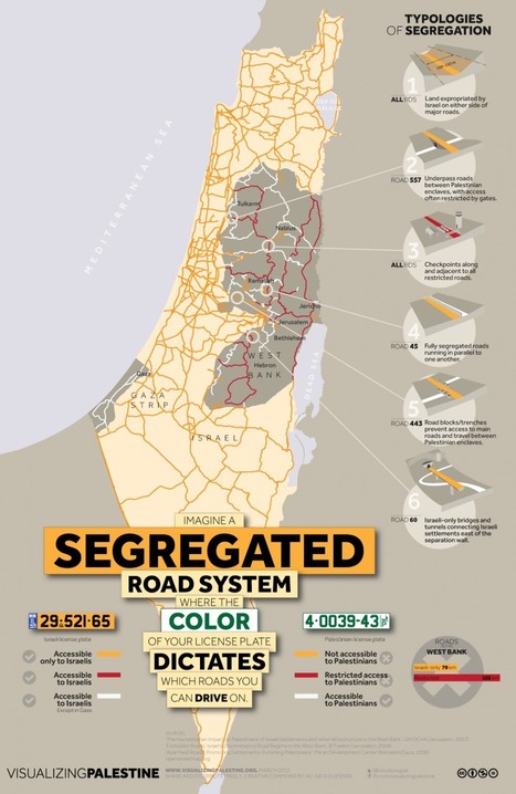
Tags: MiddleEast, territoriality, transportation, borders, conflict, governance, political, unit 4 political.

Zach & Wafeeq's curator insight,
November 4, 2014 5:04 PM
Area/Geography: This is a diagram of what Israel is like for Palestinians and Israelis. It shows extremely restricted access for Palestinians. Whereas Israelis have all of the roads. This diagram fairly falls under the Area/Geography category because of the fact of how the Israeli government is manipulating the area/geography of the land of Israel to suit their best interest. 
Jacqueline Garcia pd1's curator insight,
March 22, 2015 3:33 PM
Here one can see the political territoriality among Israel. For example in this article webpage we saw that people with Palestinian license plates can not drive on Israeli roads. This is one of the many instances where people are segregated according to their beliefs. 
Olivia Campanella's curator insight,
October 31, 2018 11:30 AM
In this article you can see a map of how the roads in the Palestinian territories were split. There is a key down at the bottom to see which roads were for Israel and which were for Palestinians.
Scoop.it!

Due membri delle Pussy Riot hanno lasciato la Russia per evitare un nuovo procedimento giudiziario.
Scoop.it!

TM NewsGossip/ Valeria Bruni Tedeschi e Louis Garrel si lascianoTM NewsMilano, 15 set.
|