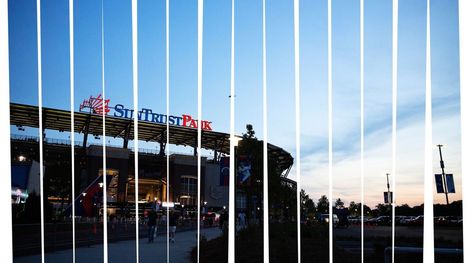
BARCELONA in Flow Motion - A fast moving short film.... Gold prize winner at Timelapse Showfest 2014 In few other cities is it possible to walk from spectacular…
In 1965, voters from the five counties that still make up metro Atlanta—Cobb, Fulton, Gwinnett, Clayton and DeKalb—went to the ballot box to decide the future of the region’s public transportation system. The counties that voted “yes” would begin planning a regional rail system that would eventually be called MARTA (Metro Atlanta Rapid Transportation Authority); counties that voted “no” would be excluded from the system. Fulton, Gwinnett, Clayton, and Dekalb passed the resolution while Cobb County voted it down. To this day, the closest MARTA comes to operating in Cobb County is a single bus route that runs from Midtown Atlanta to the Cumberland Transfer Center, just across the county line.
The liveability of urban slums in the developing world makes an interesting study linking access to services and facilities, community identity, social connectedness, environmental quality and safety.
Historic Aerials provides free online access to historical aerial photography, current aerial photos and topographic (topo) maps. You can view aerial photography from the 1920s through today. Use our multi-year comparison tools to detect changes in property. Come and explore your favorite points of interest.
"What Cezanne did for apples, Rob Whitworth does for city traffic" - Robert Krulwich - National Public Radio (NPR) Rob Whitworth is a prominent urban filmmaker…
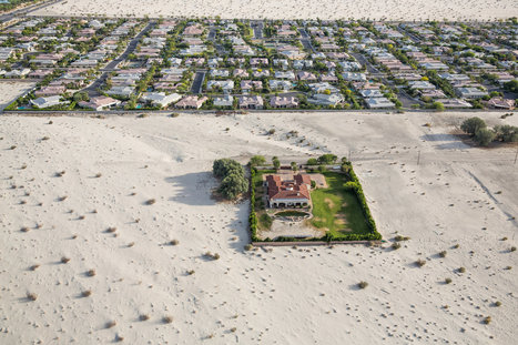
A punishing drought is forcing a reconsideration of whether the aspiration of untrammeled growth that has for so long been the state’s engine has run against the limits of nature.
"In 'How to Make an Attractive City,' a new video from the School of Life, London-based Swiss writer Alain de Botton offers a cheeky, thought-provoking, six-point manifesto on the need for making beauty a priority in urban architecture and design."
History is a major attraction to tourists in any city, and Paris seems to have all these requirements to be a good urban city. The variety in architecture that is blended in within past and present structures gives a distinct look and attraction. Planning, of course, would help satisfy public expectations and the variety of culture and color would add to the delightful qualities of the city. Amenities contribute to the diversity of the city and businesses affect the image of culture in the city.
Several hundred million more people are expected to move to cities in East Asia over the next 20 years as economies shift from agriculture to manufacturing and services, according to a World Bank report
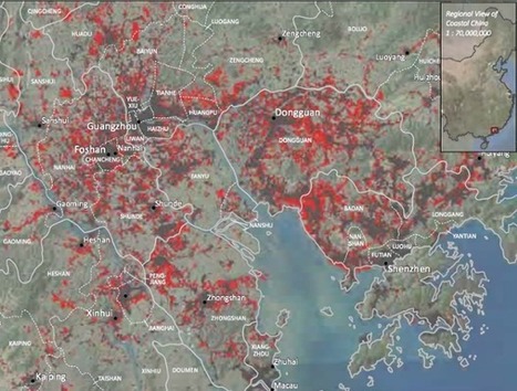
Cities in this region have experienced spectacular growth; they are at the heart of China's manufacturing and exporting boom. For example, Shenzen was a small city with about 10,000 residents in 1980 but is now a megacity with over 10 million people. China's SEZs (Special Economic Zones). Cities that were once separate entities have coalesced into a large conurbation and if they are counted as one, it's now the largest metropolitan area. Cities like London and New York become global cities over hundreds of years--this happened in one generation. Click here for 5 infographics showing East Asia's massive urban growth.
Tags: APHG, urban, industry, manufacturing, economic, unit 7 cities, megacities, China, East Asia.
These photographs - part of an anti-poverty advertising campaign by a Mexico City-based agency - show an ocean of tumbledown concrete apartments next to smart, colourful residences.
It is interesting how the demographic pattern of Favela serve as the only option for the housing of the poor in Brazil. The lack of jobs and better opportunities force many families to build their houses in the heel of the mountains. However, these mountain based houses are faced with many severe problems involving electricity, sewage, and water. The city offers a lot of opportunities for everyone, except for the poor who are the most in need. Transportation is another issue for these impoverished communities. It takes a lot of time to go up and down from these favelas, and becomes difficult for those that live on the highest peaks. Another important concern is drugs and crime rates that make these poor neighborhood dangerous in which to reside. Favelas are typical houses in the Brazil, which has the highest percentage of poverty out of all South American countries. In the meantime, favela will continue to serve as the permanent residencies of those too poor to afford housing in the Brazilian urban landscape.
This slide show teaches you what primate cities are and gives you an example and background of one. It teaches you about Mexico City and the characteristics of it.
This article relates to Unit 7: Cities and Urban Land Use because it teaches you about primate cities. Primate cities have disproportionately large populations and is over two times larger than the next largest city in the country
Mexico City is a primate city, since it's population is significantly larger than any other city in Mexico. Primate cities are only deemed primate cities if they are double or more the population of the running up city.
Primate cities show population distribution since a large majority of the population is centralized around one area.
Tokyo, Japan is the original mega-city, a throbbing, dynamic metropolis of 32.5 million people, well over 50 percent more massive than the world's next large...
As I was walking home from work in San Francisco a number of years ago, a Days Inn caught my eye. The hotel itself is nothing special, but it sat at an odd angle to the street. Why would anyone build that way, I wondered.
Land-use theories, like the galactic city model, are key to understanding urban geography. This guide will help you master the AP Human Geography Exam.
atistics are like crystal balls -- when examined closely, they can help predict a country’s future (and give important clues about the past). Kim Preshoff explains how using a visual tool called a population pyramid helps policymakers and social scientists make sense of the statistics, using three different countries' pyramids as examples.
BARCELONA in Flow Motion - A fast moving short film.... Gold prize winner at Timelapse Showfest 2014 In few other cities is it possible to walk from spectacular…
Definitely a good way for multi-purpose land use. They are utilizing the space they have conservatively, they really nailed this one on the head coming up with an idea to put a market right on a railroad track. Is this concept even safe or sanitary? Most definitely not. First off, it is not sanitary because that train on a daily basis has gone through all sorts of dirt and the train is literally passing right over the farmer's food that he is still going to sell to customers. Also, probably not the safest, because the people are just inches away from the passing train and with the wrong move, they can possibly fall onto the track and they are dead. I will hand it to them though, they act in an orderly fashion and move swiftly both when it comes and when it leaves. As a matter of fact, they go on with life so well after it leaves, it is almost like the train never passed through in the first place.
In one video we see issues surrounding urban development, city planning (or lack thereof), population density, and land use, among other topics. As more and more people move into Southeast Asia's unplanned cities, there will be more crowding and people will have to use every last available inch of land, even if that means going right up to the train tracks. This is a culture shock to people in the West, where most land is single-use only.
Urban planning in a rapidly urbanizing area can be difficult, but in this area two very different urban entities use the land together so beautifully. This market was built around the train tracks and when the train passes through at a slow speed the market clears the tracks and both work together so flawlessly. This is uncommon for us to see because many cities in America had room to grow and expand and had ample planning time because urbanization happened much slower than it is in Asia, with urbanization happening so fast the countries need to use their space flexibly.
**RUNNER UP, PEOPLE'S CHOICE AWARD**URBAN DESIGN FINALISTA home building and improvement program run by a 25-year-old Mexican NGO. Echale homes are made of adobe bricks called Adoblock, which use local soil. The homes have other environmentally-friendly technologies like rainwater collection systems and solar heating.
"Fans may not list which team they favor on the census, but millions of them do make their preferences public on Facebook. Using aggregated data provided by the company, we were able to create an unprecedented look at the geography of baseball fandom, going down not only to the county level, as Facebook did in a nationwide map it released a few weeks ago, but also to ZIP codes."
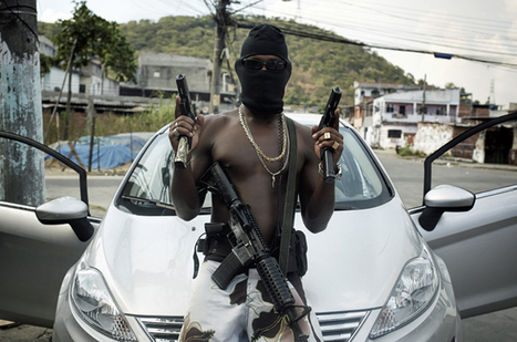
The Brazilian government's 'pacification' initiative has led to drug busts and shootouts in Rio's favelas.
Just a few months before Rio de Janeiro welcomes visitors for the World Cup, and two years before it hosts the Olympics, security within the city remains a major issue. The government currently promotes the policy of "pacification", where security forces engage in raids, drug busts, and even gunfights with suspected gang members. This pacification policy is supposed to pave the way for the development of long-neglected favelas in Rio, Brazil's second-biggest city and home to 11 million people. However, many of the favelas remain in the hands of an army of drug dealers and criminals who are not willing to step down or be pacified.
I believe that absolutely no one is surprised that right before an international event, the hosting city is cracking down on its problem areas. I am skeptical of the Brazilin governments promise to develop the long neglected Favelas. After Rio finishes hosting the 2016 Summer games, the government will once again neglect the Favelas. There will no longer be an incentive for the government to care about the favelas. The eyes of the world will be off the city and things can return to normal. The only losers in this equation are the actual residents of these slums. Once again the promise of better days will ripped from them. An added injury is that there informal economy will have been destroyed. While life in an informal economy is hard by any measure, it is still a way of making a living. The increased police presence will destroy that way of life and replace it with empty promises.
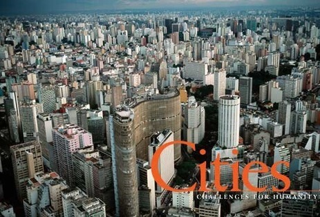
"By 2030, two out of three people will live in an urban world, with most of the explosive growth occurring in developing countries. For a preview of the future, the last in the Challenges for Humanity series explores São Paulo, Brazil; Lagos, Nigeria; Bangkok, Thailand; and Hyderabad, India."
I thought this article was good as it gave information on how the world as we know it is growing and cities are popping up everywhere. Developing countries are seeing a large increase in growth and with that comes the growth of cities. With this, more megacities will be born and hopefully the quality of life increases with life in cities.
To get content containing either thought or leadership enter:
To get content containing both thought and leadership enter:
To get content containing the expression thought leadership enter:
You can enter several keywords and you can refine them whenever you want. Our suggestion engine uses more signals but entering a few keywords here will rapidly give you great content to curate.


 Your new post is loading...