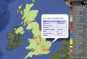
This Sway builds on the topics covered in 'An introduction to quantitative and cartographic skills for fieldwork using ArcGIS Online', which covered the basics of creating, adding and mapping data to
This Sway builds on the topics covered in 'An introduction to quantitative and cartographic skills for fieldwork using ArcGIS Online', which covered the basics of creating, adding and mapping data to
Test your knowledge and understanding of key A Level Geography topics with our growing collection of revision quizzes. For the latest news of all our Geography
Just a few tips on exam technique - apologies for the poor editing I was trying to get it done in time for a revision lesson! Will upload a better edited ver...
A simpler explanation of standard deviation, written by a former math-major-turned-journalist who likes to explain math to people don't understand or just plain hate it.
Objective: To be able to use and recognise a variety of map symbols and to understand why they are used. IST Learner Profile Link - Knowledgeable & Inquirer New activity for 2016 - Emoji mappin
To get content containing either thought or leadership enter:
To get content containing both thought and leadership enter:
To get content containing the expression thought leadership enter:
You can enter several keywords and you can refine them whenever you want. Our suggestion engine uses more signals but entering a few keywords here will rapidly give you great content to curate.


 Your new post is loading...