Your new post is loading...

|
Scooped by
Pôle Veille AgroParisTech
November 30, 2013 12:37 PM
|
Team Location: North Central Climate Science Center, Fort Collins, Colorado
Enhanced vegetation index (EVI) image of Fraser Experimental Forest derived from Landsat 5 imagery. This image was taken in July 2010.
|
|
Scooped by
Pôle Veille AgroParisTech
November 30, 2013 12:35 PM
|
Le satellite servira à conduire des expérimentations scientifiques, mener des études topographiques, surveiller le rendement des cultures céréalières et aider...
|
|
Scooped by
Pôle Veille AgroParisTech
November 30, 2013 12:29 PM
|
Team Location: University of Georgia, Athens, Georgia
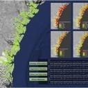
Time series analysis of salt marsh habitats across the Georgia Coast. Image Credit: Georgia Ecological Forecasting Team, NASA DEVELOP National Program.
|
|
Scooped by
Pôle Veille AgroParisTech
November 30, 2013 12:25 PM
|
Team Location: Wise County Clerk of Court’s Office, Wise, Virginia; and Langley Research Center, Hampton, Virginia Energy demand (2010) based on average energy consumption per capita and population distribution data from Suomi NPP satellite and...
|
|
Scooped by
Pôle Veille AgroParisTech
November 30, 2013 12:08 PM
|
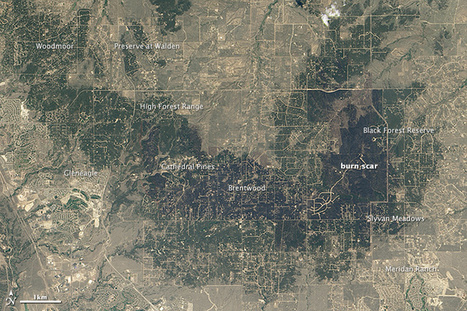
How development patterns helped make the Black Forest fire so damaging.
|
|
Scooped by
Pôle Veille AgroParisTech
November 30, 2013 12:01 PM
|
Team Location: Goddard Space Flight Center, Greenbelt, Maryland
A calculated water basin surrounding the Amboseli National Park, and a portion of Mt. Kilimanjaro. Flow accumulation is shown in white and blue.
|
|
Scooped by
Pôle Veille AgroParisTech
November 30, 2013 11:51 AM
|
By Domingos Xavier Viegas1, Christoph Aubrecht2,3, Sergio Freire4 1 University of Coimbra, Department of Mechanical Engineering 2 AIT Austrian Institute of Technology, Energy Department 3 The World Bank, LAC Urban and Disaster Risk Management 4...
La biomasse forestière est une information capitale pour l’étude du cycle du carbone mais difficile à mesurer à l’échelle globale. La mission BIOMASS permettra de relever ce défi en fournissant une cartographie bi-annuelle de la biomasse des forêts à l'échelle mondiale. Celle-ci permettra d’améliorer les estimations des stocks et flux de carbone des écosystèmes forestiers, en particulier pour les régions tropicales actuellement les plus critiques vis-à-vis du bilan de carbone du fait notamment de la déforestation, et ainsi de mieux comprendre le rôle des puits et sources de carbone dans le changement climatique. BIOMASS devrait également ouvrir des perspectives d’exploration de la structure du sous-sol terrestre, notamment pour les surfaces arides, englacées ou gelées en permanence (pergélisol).
Via Le CNRS Occitanie Ouest
|
|
Scooped by
Pôle Veille AgroParisTech
November 30, 2013 11:38 AM
|
Vers une gestion fine à la parcelle en tenant compte de ses ...
La France Agricole
... développés pour l'intrant eau.
|
|
Scooped by
Pôle Veille AgroParisTech
November 10, 2013 4:46 AM
|
La Chine lance un satellite de télédétection Quotidien du Peuple Le satellite de télédétection Yaogan XVIII a été lancé mardi à 10H50 par une fusée porteuse Longue marche 2C depuis le centre de lancement de satellites de Taiyuan, capitale de la...
|
|
Scooped by
Pôle Veille AgroParisTech
November 10, 2013 4:38 AM
|
Prendre la mesure de l'enjeu
Paysan Breton
Pour les contrôles de surfaces, environ 70 % se font par télédétection. Un taux élevé de dossiers est accepté dans le cadre de ce contrôle administratif.
|
|
Scooped by
Pôle Veille AgroParisTech
November 8, 2013 8:12 AM
|
A photograph by an astronaut on the International Space Station shows a progressively shrinking glacier in the North Patagonian Icefield.
|
|
Scooped by
Pôle Veille AgroParisTech
November 8, 2013 8:11 AM
|
Université du Québec (Communiqué de presse) Les drones au service de la recherche en océanographie Université du Québec (Communiqué de presse) Spécialiste en télédétection, le professeur en océanographie physique Martin Montes travaille sur un...
|
|
|
Scooped by
Pôle Veille AgroParisTech
November 30, 2013 12:37 PM
|
Team Location: Wise County Clerk of Court’s Office, Wise, Virginia; and Tecnológico de Monterrey Campus Saltillo, Saltillo, Mexico
Normalized Differential Drought Index of Coahuila Mexico (Drought).
|
|
Scooped by
Pôle Veille AgroParisTech
November 30, 2013 12:31 PM
|
Satellite views of night lights help reveal the strings of roads, rails, and rivers than connect the citizens of the United States.
|
|
Scooped by
Pôle Veille AgroParisTech
November 30, 2013 12:27 PM
|
Team Location: Langley Research Center, Hampton, Virginia; and Patrick Henry Building, Richmond, Virginia
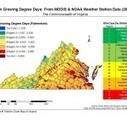
Map showing Degree Days during the growing season (April 1-Oct. 31). A list of suggested grape varietals per region is provided.
|
|
Scooped by
Pôle Veille AgroParisTech
November 30, 2013 12:22 PM
|
Maxisciences
B-31, l'iceberg géant, dérive en Antarctique sous l'œil des satellites
Futura Sciences
Les dernières photographies prises par le satellite Aqua de la Nasa conduisent à des dimensions de 35 km par 20, soit 700 km2.
|
|
Scooped by
Pôle Veille AgroParisTech
November 30, 2013 12:04 PM
|
Bienvenue sur le serveur de cours de l'ENSG. Vous trouverez ici de nombreux contenus pédagogiques que vous pouvez consulter librement.
|
|
Scooped by
Pôle Veille AgroParisTech
November 30, 2013 11:59 AM
|
Team Location: John C. Stennis Space Center, Stennis, Mississippi
(Left) NOAA scientists sample Sargassum. Image Credit: NOAA National Ocean Service. (Right) NDVI calculated on a Landsat 7 ETM+ scene from Aug.
|
|
Scooped by
Pôle Veille AgroParisTech
November 30, 2013 11:50 AM
|
|
|
Scooped by
Pôle Veille AgroParisTech
November 30, 2013 11:47 AM
|
Des banques européennes financent des exploitations illégales d ...
EurActiv France
AdT a eu recours à des images satellite, à des données commerciales, ainsi qu'à des rapports de terrain pour réaliser son rapport.
|
|
Scooped by
Pôle Veille AgroParisTech
November 30, 2013 11:28 AM
|
En bref : des pêches non déclarées identifiées avec Google Earth
Futura Sciences
Le logiciel Google Earth permet de visualiser la Terre à partir de la compilation d'images aériennes ou satellites.
|
|
Scooped by
Pôle Veille AgroParisTech
November 10, 2013 4:39 AM
|
Maxisciences
EN IMAGES. La beauté de la Terre vue des satellites
TF1
...
|
|
Scooped by
Pôle Veille AgroParisTech
November 8, 2013 8:17 AM
|
Development on the edge of the wilderness is increasing the risk of destructive wildfires in Colorado.
|
|
Scooped by
Pôle Veille AgroParisTech
November 8, 2013 8:11 AM
|
L'Express Le marché des drones prend son envol L'Express Labellisée jeune entreprise innovante, la PME bordelaise, forte de ses huit ingénieurs en recherche et développement, vient de lancer son Vitidrone spécialisé dans la télédétection des...
|


 Scoop.it!