


From the moon to the cosmos, this is the universe we live in.
Get Started for FREE
Sign up with Facebook Sign up with X
I don't have a Facebook or a X account


 Your new post is loading...
 Your new post is loading...
Your new post is loading...
From the moon to the cosmos, this is the universe we live in.
Beth Dichter's insight:
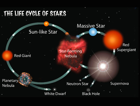
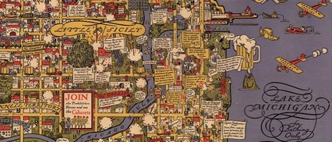
Outer space fascinates learners...and this post from VOX provides 40 maps that are divided into sections: * The Solar System * Earth * Space History * The Moon * Mars * The Rest of the Solar System * Beyond the Solar System If you teach Earth Science many of these maps may be of interest. One map that many students may find of interest is takes a look at the universe based on the moon being 1 pixel. It is located at this link. 
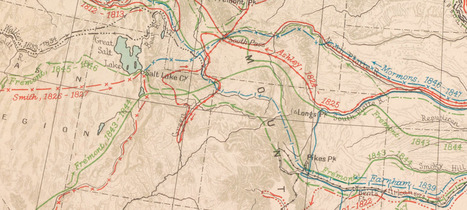
"Here you will find one of the greatest historical atlases: Charles O. Paullin and John K. Wright's Atlas of the Historical Geography of the United States, first published in 1932. This digital edition reproduces all of the atlas's nearly 700 maps. Many of these beautiful maps are enhanced here in ways impossible in print, animated to show change over time or made clickable to view the underlying data—remarkable maps produced eight decades ago with the functionality of the twenty-first century."
Beth Dichter's insight:
This old atlas provides new functionality due to technology! Maps have been georectified, many are animated allowing you to see a progression over time, many are clickable providing access to data such as population demographics or crop production, and much more. Have fun exploring.
Beth Dichter's insight:
Are you looking for ways to learn online this year? Check out this post which provides 13 possibilities for you to explore. A few of them are: * Get inspired by great speeches - listen to speeches from turning points in history, movies and more! * Directory of open access journals - do you need to research a topic? Check out journals that provide free access. * Publish your own graphic novel - Use Comic Master to write a graphic novel (or perhaps, have students in your class use it). * Explore maps - new and old. With GPS we may neglect maps, yet maps are an amazing tool. Learn about geograpgy, culture, history and more as you explore old maps (and new) at a variety of websites. Nine additional links await you when you click through to this post!
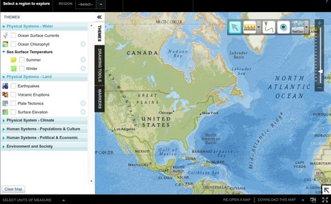
National Geographic Education beta has a new tool, MapMaker Interactive, that allows you to explore your world with maps. Select the region you want to map. There are options for themes, data and tools that allow for customization. Themes include Physical Systems: Water, Land and Climate; Human Systems: Population & Culture and Political and Economic; and Environment and Society. There are drawing tools and markers and you may download maps that you create. There is also a version that is black and white that has basic map elements as well as borders and names and other features. These maps may be printed out. The link to this is http://education.nationalgeographic.com/education/mapping/outline-map/?map=USA&ar_a=1.

Lindsay Hoyt's curator insight,
June 26, 2017 11:31 PM
Great tool for World History and U.S. History classrooms.
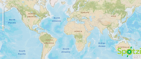
Spotzi shows you the world in a unique and astonishing way. It not only shows you street maps and high detail areal maps. That’s just a starter. Spotzi goes beyond any political border and zooms in to any aspect of our planet. This has been made possible by the extent data resources at NASA, the World Bank and our own data warehouse.
Educational resources of the U.S. Geological Survey serving primary and secondary education (K-12) repositories, reports, publications, maps, aerial photography.
|
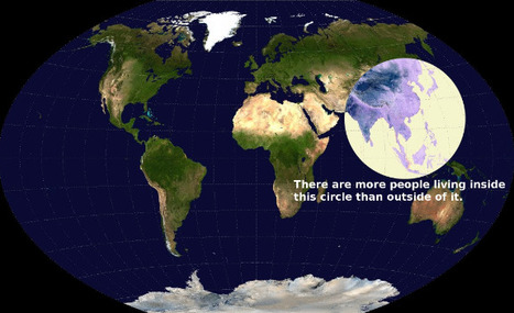
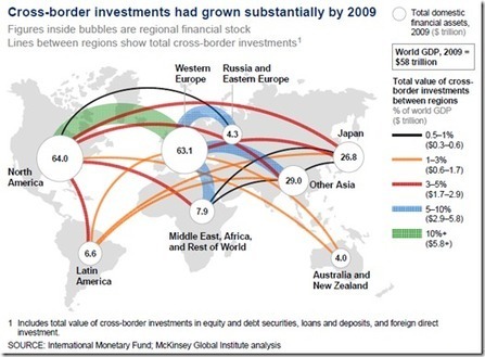
These 22 charts and maps all told me something I found surprising. Some of them genuinely changed the way I think about the world.
Beth Dichter's insight:
If you are looking for some maps that will have students scratch their heads and consider come concepts in a new light this post will provide you with 22 choices. The one above intrigued me. It shows a map of the world, and has a circle that shows where more people live than the rest of the world. I suspect this image would bring up many questions, and that many would be interdisciplinary. Click through to the post to find many other great maps and charts.

Gary Harwell's curator insight,
October 5, 2014 2:06 AM
Some cool stuff to share with your students. 
Leah Hood's curator insight,
August 22, 2017 4:54 PM
If you are looking for some maps that will have students scratch their heads and consider come concepts in a new light this post will provide you with 22 choices. The one above intrigued me. It shows a map of the world, and has a circle that shows where more people live than the rest of the world. I suspect this image would bring up many questions, and that many would be interdisciplinary. Click through to the post to find many other great maps and charts.
If you're a visual learner like myself, then you know maps, charts and infographics can really help bring data and information to life. Maps can make a point resonate with readers and this c...
Beth Dichter's insight:
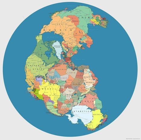
Maps are great visuals for teaching about concepts of space (as in spatial intelligence) and data. This collection of forty maps is diverse and you will find quite a few that you may want to share with students but check them out first. Based on the grade level you teach there may be maps you will not share. Luckily there are links to where the map was first found. A few of the maps are listed below. The one in the image is a "Map of 'Pangea' with Current International Borders." * Countries that do not use the Metric System * The Only 22 Countries in the World that Britain has not Invaded * Map of Time Zones in Antarctica * Global Internet Usage Based on Time of Day * World Map of Earthquakes since 1898 * The 7000 Rivers that Feed the Mississippi River
Who says that learning has to be lame? Take the boring out of those old Social Studies books add in cool stories, links, and videos, and you get Go Social Studies Go. Currently there are 6 sections: Global Religions, History (ancient, medieval, 19th & 20th century, colonial, American), World Geography, Choose Your Own Adventure (The Underground Railroad and Immigration with more to be added), History Legal Files (the Trial of Marie Antoinette with Brown vs Topeka Board of Ed. to be added soon), Cool Sites (a Scoop.it site by Go Social Studies Go), and Teacher Resources (a wikispaces site). It appears that additional information will be added. If you teach social studies check this site out, and share it with others!
The OldMapsOnline Portal is an easy-to-use gateway to historical maps in libraries around the world. It allows the user to search for online digital historical maps across numerous different collections via a geographical search. Search by typing a place-name or by clicking in the map window, and narrow by date. The search results provide a direct link to the map image on the website of the host institution.

Visual literacy has practical uses across the curriculum. Learning science, technology, social studies, health and nutrition, history and geography, mathematics, arts and crafts all rely on visual texts such as maps, diagrams, graphs, timelines or tables. Find many free items and ideas on this website, which is geared to Grades K - 8.
An addictive collection of beautiful charts, graphs, maps, and interactive data visualization toys -- on topics from around the world.
|


Thx Beth Dichter! This is terrific!
Thx Beth Dichter