


 Your new post is loading...

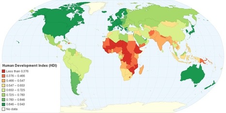

"This map shows Human Development Index (HDI) for 169 countries in the World. The HDI is a comparative measure of life expectancy, literacy, education, and standard of living for countries worldwide. The HDI sets a minimum and a maximum for each dimension, called goalposts, and then shows where each country stands in relation to these goalposts, expressed as a value between 0 and 1, where greater is better. The Human Development Index (HDI) measures the average achievements in a country in three basic dimensions of human development: health, knowledge and standard of living."
Tags: development, statistics, worldwide.


This article discusses the Human Development Index (HDI), what it is, and how it is calculated.
This chart displays that the top three spots on the HDI are occupied by Norway, Australia, and the Netherlands respectively, with the USA coming in fourth. As HDI is calculated by comparing aspects like literacy, standard of living, education, and life expectancy, why are two European countries and Australia in the top 3? Something to be looked at is the in-migration of each country. Immigrants arrival in large numbers in some countries can lower HDI if they are refugees or come from a country with a lower HDI, for they may be illiterate, have a low education, and therefore a low life expectancy. With in migration to the US tightly controlled but in constant motion, their HDI could be pulled down to 4th. As Norway and Australia and the Netherlands are not the main destination for refugees, their HDI could be higher.
The HDI is the human development index which ranks countries in many different aspects. The higher the country the more developed and modern it is. The least amount of death and the longest lives are here. It is more stable the higher the country.
This relates to the topic in unit 6 of HDI. this map shows the basic HDIS of the world and the patterns formed by the HDI layout of the world.
This map shows the Human Development Index around the world. The HDI depends on a set list of variables, ranking them from 1st to last. Nations considered to be "Western" are more developed than nations in regions such as Africa and Asia, although all nations are slowly but steadily developing, improving their Human Development Index ranking.
The HDI shows development in nations, although leaving out Inequality factors. This map also allows us to see spatially what regions tend to be more developed as well as developing.