


 Your new post is loading...


In the construction world, 3D modelling and model-based design, which integrate BIM, GIS and survey, and laser-scanning (LiDAR) in a 3D visualisation environment, are increasingly being used to improve the design and build phases of the construction process.
According to McGraw-Hill Construction, the overall adoption of BIM has increased from 17% in 2007 to 71% in 2012 in the US, registering a 45% growth over the last three years, or 400% growth over the last five years. McGraw-Hill Construction estimates that the use of BIM for infrastructure is about three years behind the BIM use on vertical projects but predicts that adoption in the horizontal market will occur at a faster rate than the rate of adoption in the vertical market.
Via Jed Fisher


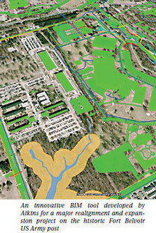
#BIM and #GIS convergence continues to gain ground.
Software BIM/GIS Companies like bim+ (bimplus.net), Onuma, ESRI, Revizto, Trimble, Autodesk, Bentley, and others seem to be seeing this and are working on some innovative solutions. (For example, take a look at an earlier Onuma Ted talk http://sco.lt/4yGuSf ;).
It makes a lot of sense, afterall, we now have an intelligent building BIM model that is connected to a ton of Information. Once the building is built it needs to run, that means monitoring energy, water/grid usage, even see the parking and population effect. Plus of course surveying and visualization needs (e.g. things get really exciting when you can look at a building with VR/AR x-ray vision on an see the infromation you need).
Smart Buildings make Smart Cities.