Télédétection veille IST INRAE & AgroParisTech
131.4K views | +3 today
Follow
Télédétection veille IST INRAE & AgroParisTech
Veille effectuée sur la télédétection - Curated by IST INRAE & AgroParisTech
Your new post is loading...

Popular Tags

Scooped by Pôle Veille AgroParisTech
November 3, 2013 8:22 AM
Scoop.it!

Getting Dirty to Understand Salt Marsh Dieback

Getting Dirty to Understand Salt Marsh Dieback | Télédétection veille IST INRAE & AgroParisTech | Scoop.it
VPS Project Title: Getting Dirty to Understand Salt Marsh Dieback Project Team: Georgia Ecological Forecasting Team (shubho@uga.edu) Team Location: University of Georgia, Athens, Georgia Time series analysis of salt marsh habitats across the...
No comment yet.
Scooped by Pôle Veille AgroParisTech
November 2, 2013 2:54 PM
Scoop.it!

Mapping Where No White Oak Has Gone Before

Mapping Where No White Oak Has Gone Before | Télédétection veille IST INRAE & AgroParisTech | Scoop.it
Species distribution map of White Oak. Areas in red show high probability of the species occurrence where blue show low probability of species occurrence. Image Credit: Cumberland Ecological Forecasting Team, NASA DEVELOP National Program.
No comment yet.
Scooped by Pôle Veille AgroParisTech
November 2, 2013 2:48 PM
Scoop.it!

La Chine lance un satellite de télédétection - Centre d'Informations Internet de Chine

La Chine lance un satellite de télédétection Centre d'Informations Internet de Chine Le satellite de télédétection Yaogan XVIII a été lancé mardi à 10H50 par une fusée porteuse Longue marche 2C depuis le centre de lancement de satellites de...
No comment yet.
Scooped by Pôle Veille AgroParisTech
November 2, 2013 2:14 PM
Scoop.it!

Fall Colors in Pennsylvania

Fall Colors in Pennsylvania | Télédétection veille IST INRAE & AgroParisTech | Scoop.it
Cooler temperatures and shorter days have transformed Pennsylvania’s forests.
No comment yet.
Scooped by Pôle Veille AgroParisTech
November 2, 2013 2:11 PM
Scoop.it!

Utilizing NASA EOS to Expand Agricultural Production in Virginia

Utilizing NASA EOS to Expand Agricultural Production in Virginia | Télédétection veille IST INRAE & AgroParisTech | Scoop.it
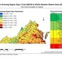
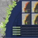
VPS Project Title: Utilizing NASA EOS to Expand Agricultural Production in Virginia Project Team: Virginia Agriculture Team Team Location: Langley Research Center, Hampton, Virginia; and Patrick Henry Building, Richmond, Virginia Map showing Degree...
No comment yet.
Scooped by Pôle Veille AgroParisTech
November 2, 2013 2:09 PM
Scoop.it!

Satellites Becoming Vital to International Development

Satellites Becoming Vital to International Development | Télédétection veille IST INRAE & AgroParisTech | Scoop.it
Envisat Advanced Synthetic Aperture Radar (ASAR) of the Mekong Delta, Vietnam. Image Credit: EOWorld.
No comment yet.
Scooped by Pôle Veille AgroParisTech
October 26, 2013 10:34 AM
Scoop.it!

Rapid error assessment for quantitative estimations from Landsat 7 gap-filled images

Rapid error assessment for quantitative estimations from Landsat 7 gap-filled images | Télédétection veille IST INRAE & AgroParisTech | Scoop.it

The failure of the Scan Line Corrector (SLC) of the Landsat ETM+ (Enhanced Thematic Mapper Plus) instrument in 2003 had resulted in missing values for 22% of each scene. As the remaining pixels were of high quality, several procedures had been developed to fill the gaps and increase the usability of the SLC-off images. In this letter, a methodology is presented to assess the error when estimating quantitative parameters from gap-filled Landsat 7 images. The error from the gap-filling procedure was estimated using an external reference image. The methodology was applied in a Mediterranean river basin using two types of gap-filling methods and the error was estimated for leaf area index (LAI), actual evapotranspiration (ETa) and soil moisture in the rootzone (SMrz), three remotely sensed products which are commonly used in hydrological studies. The results suggest that the interpolation method had lower errors in all examined products. The proposed methodology is an imperative step that each user of gap-filled products could use to estimate the associated error before using the maps.

No comment yet.
Scooped by Pôle Veille AgroParisTech
October 26, 2013 10:23 AM
Scoop.it!

La télédétection laisse entrevoir des pistes prometteuses - LE MATiN

La télédétection laisse entrevoir des pistes prometteuses - LE MATiN | Télédétection veille IST INRAE & AgroParisTech | Scoop.it
LE MATiN La télédétection laisse entrevoir des pistes prometteuses LE MATiN Aujourd'hui, toute une gamme de satellites, à haute, moyenne et basse résolution, permet de surveiller l'environnement, faire des comparaisons dans le temps et l'espace et...
No comment yet.
Scooped by Pôle Veille AgroParisTech
October 26, 2013 10:21 AM
Scoop.it!

Suivi de la couche active de surface et du pergélisol au québec et en arctique par télédétection satellite

No comment yet.
Scooped by Pôle Veille AgroParisTech
October 25, 2013 3:18 AM
Scoop.it!

Les technologies spatiales contribuent à la coopération ... - Quotidien du Peuple

Les technologies spatiales contribuent à la coopération ... - Quotidien du Peuple | Télédétection veille IST INRAE & AgroParisTech | Scoop.it
Les technologies spatiales contribuent à la coopération ...
Quotidien du Peuple
24.10.2013 à 16h23.
No comment yet.
Scooped by Pôle Veille AgroParisTech
October 25, 2013 3:17 AM
Scoop.it!

Oil and gas sector gears up for Sentinels

Oil and gas sector gears up for Sentinels | Télédétection veille IST INRAE & AgroParisTech | Scoop.it
Originally Published by ESA Observing the Earth
The international body representing the oil and gas industry is promoting the use of satellite Earth observation as the industry explores new frontiers.
No comment yet.
Scooped by Pôle Veille AgroParisTech
October 24, 2013 11:59 AM
Scoop.it!

R&D spatiale: Le Technion prépare une nuée de satellites miniatures - IsraelValley

R&D spatiale: Le Technion prépare une nuée de satellites miniatures - IsraelValley | Télédétection veille IST INRAE & AgroParisTech | Scoop.it
R&D spatiale: Le Technion prépare une nuée de satellites miniatures IsraelValley L'ISA s'apprête à lancer avec le CNES (Centre national d'études spatiales) français le satellite VENmicro-S (Vegetation and Environment monitoring on a New...
No comment yet.
Scooped by Pôle Veille AgroParisTech
October 24, 2013 11:58 AM
Scoop.it!

The Power of Spatial information is its Tangibility

The Power of Spatial information is its Tangibility | Télédétection veille IST INRAE & AgroParisTech | Scoop.it
By Sara LaFia
California State Polytechnic University, Pomona, California, U.S.
A team of DEVELOP interns at NASA Langley Research Center have utilized NASA’s Earth Observing System to assess North Carolina’s exceptionally harsh 2011 wildfire season.
No comment yet.
Scooped by Pôle Veille AgroParisTech
November 2, 2013 2:55 PM
Scoop.it!

Drought Drought Everywhere, And Not a Model to Use: Monitoring Drought in Uruguay

Drought Drought Everywhere, And Not a Model to Use: Monitoring Drought in Uruguay | Télédétection veille IST INRAE & AgroParisTech | Scoop.it
VPS Project Title: Drought Drought Everywhere, And Not a Model to Use: Monitoring Drought in Uruguay Project Team: Uruguay Agriculture Team Team Location: International Research Institute for Climate and Society, Palisades, New York The DSI (using...
No comment yet.
Scooped by Pôle Veille AgroParisTech
November 2, 2013 2:52 PM
Scoop.it!

Flooding along the Heilong River

Flooding along the Heilong River | Télédétection veille IST INRAE & AgroParisTech | Scoop.it
2013 brought record flooding to the Amur (Heilong) River.
No comment yet.
Scooped by Pôle Veille AgroParisTech
November 2, 2013 2:19 PM
Scoop.it!

New 3D Imagery in Detroit, Salt Lake City, and likely other cities

New 3D Imagery in Detroit, Salt Lake City, and likely other cities | Télédétection veille IST INRAE & AgroParisTech | Scoop.it
Originally Published by Google Earth Blog
While nothing has been announced by Google yet, it appears there was recently some fresh 3D Imagery released.
No comment yet.
Scooped by Pôle Veille AgroParisTech
November 2, 2013 2:11 PM
Scoop.it!

Challenges in Agricultural Practices in the Mountains of Eastern Bhutan

Challenges in Agricultural Practices in the Mountains of Eastern Bhutan | Télédétection veille IST INRAE & AgroParisTech | Scoop.it
VPS Project Title: Challenges in Agricultural Practices in the Mountains of Eastern Bhutan Project Team: Bhutan Agriculture Terra MODIS image of Bhutan, highlighting areas with higher soil moisture and vegetative growth in cyan suggesting areas for...
No comment yet.
Scooped by Pôle Veille AgroParisTech
November 2, 2013 2:10 PM
Scoop.it!

A Decade of Water

A Decade of Water | Télédétection veille IST INRAE & AgroParisTech | Scoop.it
Groundwater supplies are decreasing across much of the world.
No comment yet.
Scooped by Pôle Veille AgroParisTech
November 2, 2013 2:09 PM
Scoop.it!

Lluta River, Chile

Lluta River, Chile | Télédétection veille IST INRAE & AgroParisTech | Scoop.it
The Lluta River provides a lifeline of water to one of the driest places in the world. However, the water is steeped with arsenic and boron.
No comment yet.
Scooped by Pôle Veille AgroParisTech
October 26, 2013 10:34 AM
Scoop.it!

Using the USGS Landsat 8 Product

Using the USGS Landsat 8 Product | Télédétection veille IST INRAE & AgroParisTech | Scoop.it

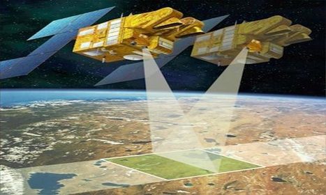
The standard Landsat 8 products provided by the USGS EROS Center consist of quantized and calibrated scaled Digital Numbers (DN) representing multispectral image data acquired by both the Operational Land Imager (OLI) and Thermal Infrared Sensor (TIRS).  


The products are delivered in 16-bit unsigned integer format and can be rescaled to the Top Of Atmosphere (TOA) reflectance and/or radiance using radiometric rescaling coefficients provided in the product metadata file (MTL file), as briefly described below.  The MTL file also contains the thermal constants needed to convert TIRS data to the at-satellite brightness temperature.  Further details can be found in the LDCM Cal/Val Algorithm Description Document and the Landsat 8 Science Users’ Handbook available from the Landsat website.

No comment yet.
Scooped by Pôle Veille AgroParisTech
October 26, 2013 10:22 AM
Scoop.it!

Apport de la télédétection et du SIG dans la prévention des épidémies de paludisme

Apport de la télédétection et du SIG dans la prévention des épidémies de paludisme - Présentation de la 4e édition du Cours international « Atelier Paludisme » - Djibrine DJALLE - Chercheur - Institut Pasteur de Bangui - République Centrafricaine ...

No comment yet.
Scooped by Pôle Veille AgroParisTech
October 26, 2013 10:21 AM
Scoop.it!

OTB: logiciel libre de traitement d’images satellites

La multiplication des capteurs et des satellites d’une part et l’amélioration des produits issus de la télédétection d’autre part se traduisent par des applications de plus en plus nombreuses dans les divers domaines de...

No comment yet.
Scooped by Pôle Veille AgroParisTech
October 25, 2013 3:17 AM
Scoop.it!

Live Fuel Moisture Content Derived from Remote Sensing Estimates in Temperate Shrublands and Grasslands

Live Fuel Moisture Content Derived from Remote Sensing Estimates in Temperate Shrublands and Grasslands | Télédétection veille IST INRAE & AgroParisTech | Scoop.it
The Eurosiberian region. Image Credit: Environmental Remote Sensing Research Group, University of Alcalá.
 
Sara Jurdaoa,, Marta Yebraa,b and Emilio Chuviecoa
a Department of Geography, University of Alcalá.
No comment yet.
Scooped by Pôle Veille AgroParisTech
October 24, 2013 11:59 AM
Scoop.it!

GEOSS Future Products: Recommendations from a Workshop

GEOSS Future Products:  Recommendations from a Workshop | Télédétection veille IST INRAE & AgroParisTech | Scoop.it
The Global Earth Observing System of Systems (GEOSS) is a platform to make varied sensor and model data available in an interoperable manner.
No comment yet.
Scooped by Pôle Veille AgroParisTech
October 24, 2013 11:59 AM
Scoop.it!

The Time to Start Building a Live Global Resource Inventory is Now

The Time to Start Building a Live Global Resource Inventory is Now | Télédétection veille IST INRAE & AgroParisTech | Scoop.it
By Fouad Khan
Central European University, Budapest
One of the factors that led to enlightenment and the transformation of European nations from feudal societies to industrialized market economies was the standardization of the bushel size.
No comment yet.