


Pix4D is your solution to convert thousands of aerial images, taken by lightweight UAV or aircraft into geo-referenced 2D mosaics and 3D surface models and point clouds.
Get Started for FREE
Sign up with Facebook Sign up with X
I don't have a Facebook or a X account


 Your new post is loading...
 Your new post is loading...
Your new post is loading...
Pix4D is your solution to convert thousands of aerial images, taken by lightweight UAV or aircraft into geo-referenced 2D mosaics and 3D surface models and point clouds. 
No comment yet.
Sign up to comment

Apple's new iPhone 5S looks pretty nifty, but the 64-bit argument is a marketing ploy, not a seriously needed capability.

UALogger is a simple and lightweight logging tool for iOS and Mac apps. It allows you to customize the log format, customize when to log to the console at runtime, and allows collection of the entire recent console log for your application. It includes the UALogger class and class methods, and a few handy macros. Via Alessio Nonni
Featured iPhone Development Resources,iOS Development Libraries,Objective-C,Open Source iOS Libraries And Tools Last year I mentioned an open source UITableView replacement library called MGBox that provided a very stylish and customizable... Via Vincent Demay
|
![Android 4.4 with full 64-bit support? [Rumor] | IOS Development | Scoop.it](https://img.scoop.it/TtBjCD5VcmpctZj3BJ4ZyDl72eJkfbmt4t8yenImKBVvK0kTmF0xjctABnaLJIm9)
Will Android 4.4 comes with full 64-bit support? It is still a rumor but Android 4.4 could be the first 64-bit Android
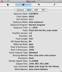
Are you writing a camera app or image editing app for iOS but are clueless on how to add geolocation to your pictures? Baffled by the lack of information in the otherwise very thorough XCode documentation? I feel your pain my friend. Or actually, felt, cause I got your meds right here.

TechCrunch’s Sarah Perez wrote an editorial this week about start-up companies who do not seem to care that “Android is better.” In her piece, she dives into reasons why start-ups choose iOS, among them being “Revenue. Development. (And Everyone Else is Doing It.)” (Sarah Perez, “Startups Apparently Do Not Care That Android is Better”). Read more at http://www.appleballa.com/2013/08/106393/why-start-ups-choose-ios-save-money-and-time-more-anything-else#I1DobY7pqROqx7lI.99 ;
How To Make an App - iOS Apps and Games Development: http://discountlink.net/app-dev-secrets/ If you want to learn how to make an app or game and be successf...
|


