URBAN EARTH is a project to (re)present our habitat by walking across some of the largest urban areas on Earth.
This is the introductory video to the Urban Earth youtube channel. The goal of this "guerrilla geography" is to see and understand the city beyond the tourism guidebook.
Daniel Raven-Ellison, the creator of the project is one of National Geographic's "Emerging Explorers" and in this video, demonstrates the methods behind his urban explorations. You can see his influence in helping found http://www.missionexplore.net as a portal for alternative geographies to engage students.
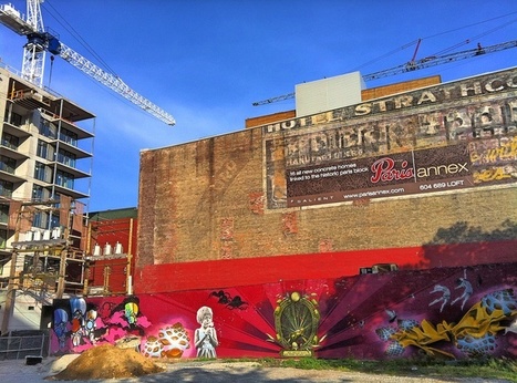
If done right, cities can preserve their character while bringing in new business...
"Gentrification can be done in a manner as such that it will not just demolish the old city but rather build upon it. Involving the residents would be a key factor in this process, more often then not it is the new ones moving in who decide the fate of the area. Retaining original buildings and recylcing them into something new helps preserve the original culture of the area. The main issue with gentrification is the loss of the familiarity within the area."
Find In-depth Review, Video And Infographic On World Population. Learn more about population growth.
This video displays some intriguing statistics about global population growth. Equally important the video explores some concerns that are presented with a large population. You can also view all the images as one long infographic. Admittedly, this video (and most academic literature) approaches the population issue from a strong perspective which advocates for the reduction of total population; if you feel it necessary to have an ideological counterweight in the classroom, this article from the LA Times may be what you are looking for.
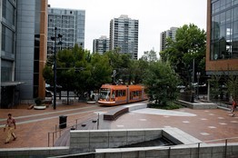
Cities from Los Angeles to Atlanta are making big bets to revitalize their downtowns by bringing back a form of transportation many abandoned decades ago: the streetcar.
The streetcar was a staple in urban development projects generations ago and was subsequently abandoned. Many mid-sized cities today (and a few large ones) are returning to that 'outdated' mode of transportation and hoping that streetcar stops will encourage businesses to open shop in those neighborhoods.
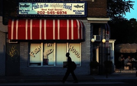
As upscale, high-rise condos and hipster bars opened nearby, longtime customers joked: Is this really still “the ’hood”? Not anymore.
In a gentrifying neighborhood in Washington D.C. that was historically African-American, Fish in the ’Hood was an iconic restaurant that captured the feel of the area. Just this May, the storefront restaurant was renamed Fish in the Neighborhood.
Questions to Ponder: Why? Does it matter? What does it mean?
Gentrification deals with the forcing out of lower income residents and making space available for the more affluent. The re-naming of Fish in the 'Hood shows how gentrification forces the culture of entire communities to change. Although this restaurant was popular before, they were forced to re-brand so they can stay in business. Gentrification exiles the poor, with that their culture. This restaurant shows that, as more upscale business open up to service the needs of more affluent citizens, any business that has the perception of being the contrary will soon be out of business. This matters because it shows how gentrification destroys communities image, and culture for the sake of increasing revenue and real estate value. What is exhibit here is not only a socio-economic shift but also a racial shift as well. This neighborhood was predominately African American before it began to gentrify, "The 'Hood" is a saying that correlates with African American culture. This restaurant's re-branding shows that they no longer can continue to bring in customers with a name that is part of the African American vernacular. Furthermore, it shows the racial trends that go with gentrification where minority culture is pushed out as more money flows in.
The article talks about a restaurant called Fish In The NeighborHood, with emphasis on Hood, that has not been affected by the gentrification that has happened in the area. He still refers to the area as "Hood" even with all the newly built building. The article also describes the process of the gentrification, and people's opinions on the name of the restaurant compared to the area.
This article relates to Unit 7: Cities and Urban Land Use because it explains the idea and process of gentrification. It gives an example of how some buildings are unaffected by the gentrified area.
this article is taking the time to plainly spell out what gentrification is and where it is happening. Gentrification means the taking of lowe class land and making it more valuable to try and boost the overall way of life in that area. Most people are blind to this system and should take the time to learn about it.
Patrick assesses the future of world order, state sovereignty, and multilateral cooperation.
The 21st century is the dawn of a new era in human history: more people on Earth live in cities than in the countryside. The impacts of this new basic fact are far-reaching. One of those is that cities that are in particular environments are more prone to certain natural disasters and will be increasingly vulnerable as their populations increase (especially megacities in the developing world).
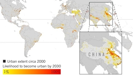
Projections of urban growth indicate areas where biodiversity is at high risk.
"Areas such as tropical Africa and eastern China are expected to be hot spots of urbanization during the next several years, according to researchers, who used satellite imagery and other data to project future urban expansion through 2030. 'We're not forecasting population, we're forecasting the expansion of urban space,' rawl, land use, urban ecology, biogeography, unit 7 cities, environment.
This article is about urban growth and decline, Africa and Asia are predicted to be hot spots of urban growth in the next few years. Geographer Karen Seto of Yale University in New Haven has creted a graph that finally accounts for variations in how individual cities occupy their land and the impact they have on local ecosystems.
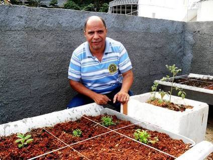
Urban Agriculture Sprouts in Brazil’s Favelas - Organic agriculture is a growing trend in big cities around the world, including Latin America, and no...
This article nicely ties two commonly taught issues in human geography that aren't the the typical combination: 1) the growth of organic farming and 2) the spread of squatter settlements and slums in the developing world.
This is a new trend spreading to Brazil. Now with the organic craze that has been going around in past years farmers have sought out way to grow their food more organically. This also allows poor areas to benefit from organic farming because it is now present in their area and they can no buy food that is good and of their choice.
Seeing how even Urbanized areas of the world can get into agriculture shows that you do not need to have geographic land advantage to grow crops. The Brazilian favelas are getting into agriculture to bring extra income and a sense of community to the area, getting more agriculture into these urban areas will be aided by the government in order to keep the urban agriculture movement growing
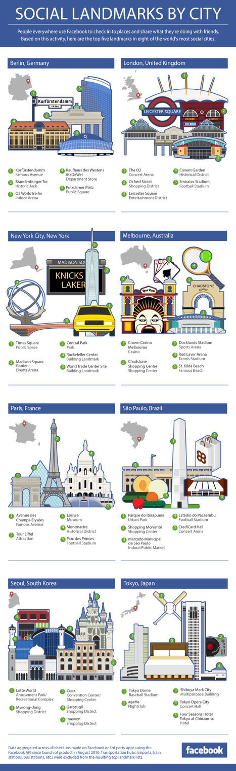
Facebook most social cities: People everywhere use Facebook to check in to places. Here you can see the 5 top hotspots of the most "social"cities.
Questions to ponder: What attributes do these commonly 'checked into' landmarks have in common? Are you surprised that some are or are not on the list?
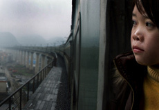
Every spring, China's cities are plunged into chaos as 130 million migrant workers journey to their home villages for the New Year in the world's largest human migration.
I've posted in the past about this documentary which portrays the The cultural importance of New Year's in China and the massive corresponding migratory shifts that take place.
"Last Train Home takes viewers on a heart-stopping journey with the Zhangs, a couple who left infant children behind for factory jobs 16 years ago, hoping their wages would lift their children to a better life. They return to a family growing distant and a daughter longing to leave school for unskilled work. As the Zhangs navigate their new world, Last Train Home paints a rich, human portrait of China's rush to economic development."
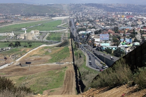
This is an important lesson, especially for those who actually live in Arizona/Mexico and have seen the border itself. Learning about the Arizona/Mexican border is important and shouldn't be left solely to teaching it only in those areas. The maps included in the lesson plan are efficient and could be used in the high school setting.
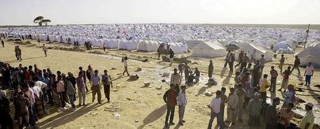
The key facts and figures about refugees, IDPs, asylum seekers and stateless people from UNHCR's annual Global Trends report.
Not all migation is voluntary. Refugees and other non-voluntary migrants often are in their situation due to complex geographic factors beyond their control at the national scale.
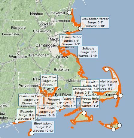
This interactive map of coastal Massachusetts and Rhode Island shows some basic flooding data including: 1) where are the flood warnings (essential the entire coastline), 2) how high the storm surge is, and 3) how high the waves are.
KV: Development of a high end apartment complex in a low income area would force pre-gentrification people out of the neighborhood. The taxes would get raised to amounts that make it difficult for these people to afford. However, the people in charge of this project are ignoring the consequences and focusing on the 5 million dollars tax break.
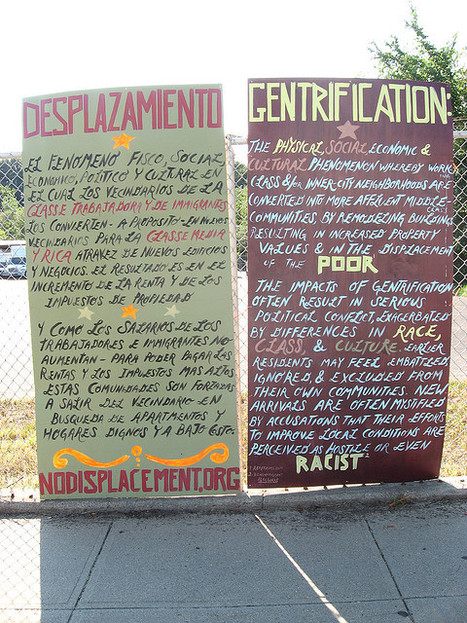
SD: This sign went up in to 2006 protest the mills-to-condo developments in Providence, Rhode Island. Click here to see the photographer's work.
Gentrification has both positive and negative affects on the city. I believe that it is beneficial for a city to take older buildings and utilize them or flip them into malls or financially beneficial businesses for their economy. But on the other hand you are taking people who were living in these areas with low rent and after you flip these buildings the rent is going to rise substancially. Therefore these former residents cannot afford to stay in the apartments and have to relocate their homes. Its hard to pick a side.
Walk Appeal promises to be a major new tool for understanding and building walkable places
What is a reasonable distance to walk around town? If walking the urban environment is and of itself an experience worth having automotive transport goes down and walking goes up.
Urban infrastructure is more important for most people than distance in deciding whether to get in the car or walk down the street (for distances under 2 miles).
Bottom line: neighborhoods that have an appealing sense of place are more walkable.
TED Talks 400 years after Hudson found New York harbor, Eric Sanderson shares how he made a 3D map of Mannahatta's fascinating pre-city ecology of hills, rivers, wildlife -- accurate down to the block -- when Times Square was a wetland and you...
Scientists have learned that world's largest cities once had a natural landscape of freshwater wetlands and salt marshes, ponds and streams, forests and fields with an equally diverse wildlife community. By focusing on the city's biodiversity of 400 years ago and the modern era, information can be gathered about what has changed, what has remained constant, where the city was done well and where it needs to improve. This source is useful because it allows for the visualization of NYC in a way never seen before. Urban environments, such as NYC, have a landscape largely created by humans, so the skyscrapers, pavement, and mass population is far removed from the landscape it once was.
a Ted talk presented by Eric Sanderson, of New York City and the before premises and lost area of New York. Basically using different map area of 3D ideas of Manhattans fascinating a pre-city different are of things that come and disappeared. This high definition map also was used for military of the American revolution to see where all the ecological, river, and wildlife is. This has a different observation in looking at the different ecological geography
I've used similar videos in my classes and students are usually quite shocked to see how a city like Bangkok, Thailand operates. I've used this as a 'hook' for lessons of population growth, urbanization, economic development, sustainability, megacities and city planning.
On the one hand this disturbed me. All I kept thinking when I saw the people go back on the tracks is that they could easily be killed.In fact, I wonder how many accidents have ever occurred near this area. All it would take is some sort of malfunction on the train in which the horn wasn’t sounding to provide ample warning or someone gets in another person’s way so there isn’t enough time to close down the shop. On the other hand, this made me realize just how efficient a population could become at using space. Everything was timed so that the entire area moved out of the way without an issue. So rather than let any land go to waste, the area uses it despite the risk to its population. Though it really isn't like the population has a choice though. So in instances where there is such overpopulation, it is interesting to see how well the society can adapt to the phenomenon. I do wonder what would happen if the country becomes more developed and the population declines. Would this type of land continue in the future or be disband? I know that in our country there are many laws that would make this illegal, but our country also has the space avoid developing the land in such a manner. When comparing it to the laws of the United States, I would think the country would eventually drift away from this use of land when possible. However, now that I watch the video, I have a new appreciation for maximizing land and I hope that the efficient could continue. Just in a less scary manner.
Talk about using every inch of space available to you. I find this video crazy not only because of the safety hazards, but just how people seem to go about this like it is normal. This would never take place in America!
An absolute amazing dynamic is seen in this video. To say that Bangkok is trying to use most of its open space up would be an understatement. In developed countries, you would not only never see this happen but you would not even see a thought of doing something like this. There are violations every where you look.
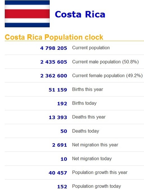
Real time statistics for current population of any country. Real time data on population, births, deaths, net migration and population growth.
This site shows various demographic statistics for every country including some based on projections in demographic trends in the given country. If the current trends hold (which they won't, but that is still an interesting measure), the entire Japanese population will disappear in 1,000 years according to this Global Post article.
I believe India has more men than women because sometimes when women can't have a son for their first or second child, the men would beat the women to death, or in some instances women are captured and sold for wives, and they may commit suicide they are so depressed. Also, some pregnant women find out their baby is a girl, they would aport or abandon her because sons are apparently more important and successful because they would stay home and take care of their parents when they are elderly and they would carry on the families name. -rt
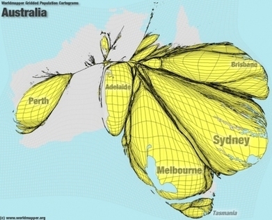
I found these cartograms from an article in the Telegraph and was immediately impressed. The cartograms originated here and use data from the Global Rural-Urban Mapping Project as to create the int...
This series of cartograms shows some imbalanced populations (such as the pictured Australia) by highlighting countries that have established forward capitals. Question to ponder: Do forward capitals change the demographic regions of a country significantly enough to justify moving the capital?
This is from 'worldmapper' - it is a great sight to help you understand using technology the most densely populated areas of various countries. What do you think they are?
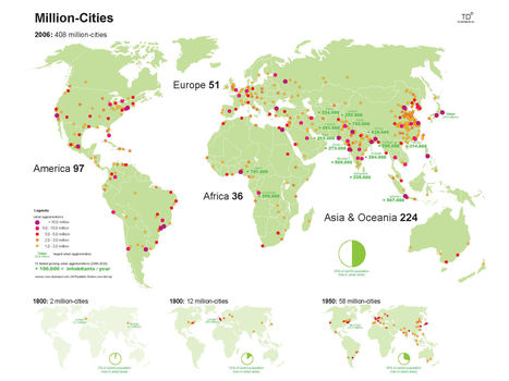
Rome was the first city with one million residents, with that occuring in 5 BC. Over a thousand years later, London and Beijing joined that group as industrialization became the impetus for wide-scale urbanization. Today we are seeing an explosion of "million cities" throughout the world.
Ian Goldin, Director of the Oxford Martin School, warns that a backlash against immigration would wreak havoc on everything from hospitals to the high-tech industry. The interview is part of the Risk Response Network’s “What if?
This is article can be an intriguing introduction to a thought exercise geared towards understanding the economic impact of migration and the social processes that create our world.
It was just over two centuries ago that the global population was 1 billion — in 1804. But better medicine and improved agriculture resulted in higher life expectancy for children, dramatically increasing the world population, especially in the West.
This is an excellent video for population and demographic units, but also for showing regional and spatial patterns within the global dataset (since terms like 'overpopulation' and 'carrying capacity' inherently have different meanings in distinct places and when analyzed at various scales). It is also a fantastic way to visualize population data and explain the ideas that are foundational for the Demographic Transition Model.
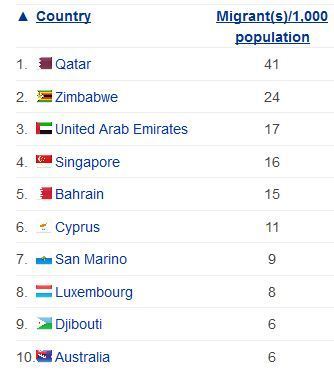
This is an interesting little chart because it reveals to us which countries have the highest percentage of migrants that make up their general population. Definitely suprised me to see Qatar as the number one on the list, I would have expected the US to be at the top, but it is not even in the top 10!
Remember this is based on a % of the total population, and not total #. Which countries have the most migrants per capita living there? What spatial or development patterns do you see on this list?
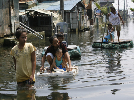
A refugee is a person who has been pushed away from their homeland and seeks refuge in another place. The United Nations High Commissioner on Refugees (UNHCR) provides a more narrow definition of a refugee as someone who flees their home country due to a “well-founded fear of being persecuted for reasons of race, religion, nationality, membership of a particular social group or political opinion.”
As Neal Lineback notes in this Geography in the News post, not all refugees are covered by this definition. Environmental refugees have been forced to leave their homes beause of soil degradation, deserticfication, flooding, drought, climate change and other environmental factors.
Refugees are found in a large percent of Earth’s surface. Some people chose to migrate, while others are forced. Some leave their home in order to get away from their country, for example due to a war. Many flee to nearby countries and are afraid to return to their hometown because they are frightened of what might happen if they go back. Another reason many refugees leave their country is due to environmental problems and the people cannot afford to live in that country.
I felt like this article was very relevant to our Unit 2, Population. We have talked about refugees and migration in a great deal and I thought this map was a good visual. I also liked the information it provided about what refugees really are and that they are really a part of the world migration pattern.
Refugees are often thought of as those with the "refugee problems" they face, the problems they create and the constant struggle they possess of never being able to go home for the political/religious dispute in their homeland.
However this articles goes into depth of the definition of a refugee and furthermore focuses on the topic of "environmental refugees' who are forced to get up and leave their land due to soul degradation, flooding, etc. - UNIT 2
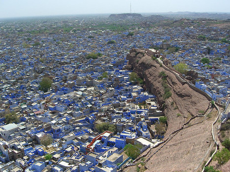
Jodhpur, India is well known for the beautiful wave of blue houses that dominate the landscape of a rather dry region. However, it is believed that these blue houses originally were the result of ancient caste traditions.
Brahmins (who were at the very top of the caste system) housed themselves in these “Brahmin Blue” homes to distinguish themselves from the members of other castes. Now that the Indian government officially prohibits the caste system, the use of the color blue has become more widespread. Yet Jodhpur is one of the only cities in India that stands steadfast to its widespread aesthetics obsession with the color blue which is making it increasingly unique, creating a new sense of communal solidarity among its residence.
The blue color shows how traditional Hindu society has influenced the overall aesthetic of the area. Because the blue signified the elite class of the society, everyone took to the color and the entire city reflects its popularity. The fact that almost every building in the city is painted the same color shows how dominant the Hindu society and culture was.
To get content containing either thought or leadership enter:
To get content containing both thought and leadership enter:
To get content containing the expression thought leadership enter:
You can enter several keywords and you can refine them whenever you want. Our suggestion engine uses more signals but entering a few keywords here will rapidly give you great content to curate.


 Your new post is loading...