Stage 5 Changing Places
8.7K views | +0 today
Follow
Stage 5  Changing Places
Resources  linked to the NSW Geography Syllabus K - 10  
Curated by GTANSW & ACT
Your new post is loading...
Scooped by GTANSW & ACT
Scoop.it!

The Invasion of America

The Invasion of America | Stage 5  Changing Places | Scoop.it

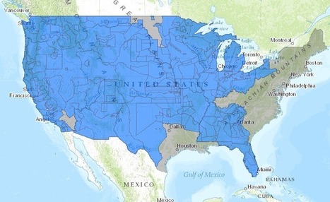
This interactive map, produced by University of Georgia historian Claudio Saunt to accompany his new book West of the Revolution: An Uncommon History of 1776, offers a time-lapse vision of the transfer of Indian land between 1776 and 1887. As blue “Indian homelands” disappear, small red areas appear, indicating the establishment of reservations (above is a static image of the map; visit the map's page to play with its features).

Courtney Barrowman's curator insight, June 23, 2014 12:25 PM

unit 1 Perception and bias of maps

Tom Cockburn's curator insight, June 24, 2014 5:51 AM

This will likely resonate with 'first peoples' everywhere

Scooped by GTANSW & ACT
Scoop.it!

Urbanization and the evolution of cities across 10,000 years

"About 10,000 years ago, hunter-gatherers, aided by rudimentary agriculture, moved to semi-permanent villages and never looked back. With further developments came food surpluses, leading to commerce, specialization and, many years later with the Industrial Revolution, the modern city. Vance Kite plots our urban past and how we can expect future cities to adapt to our growing populations."

Mirta Liliana Filgueira's curator insight, June 5, 2014 2:37 PM

La urbanización Y EVOLUCIÓN De Las Ciudades.

s smith's curator insight, June 7, 2014 9:01 PM

A great look at urbanisation. 

Fathie Kundie's curator insight, June 8, 2014 9:48 AM

تاريخ التطور الحضري

Scooped by GTANSW & ACT
Scoop.it!

American Centroid Helps To Trace Path Of U.S. Migration

American Centroid Helps To Trace Path Of U.S. Migration | Stage 5  Changing Places | Scoop.it

"David Greene talks to writer Jeremy Miller about the American Centroid. That's the place where an imaginary, flat, weightless and rigid map of the U.S. would balance perfectly if all 300 million of us weighed the exact same."

GTANSW & ACT's insight:

The centre of population in the USA has moved further inland and southward compared to Australia. Comparing urbanisation in USA and Australia.

Al Picozzi's curator insight, August 4, 2013 1:45 PM

Awesome way to show how the settlement of the US continues to move west with the population growing on the West Coast at a faster rate.  If you look at the biggest jump between 1850 and 1860 it shows the mass immigration into the US and the further migration to the western part of the US especailly with the gold rush starting in 1849.  Great littel piece of information.

Blake Welborn's curator insight, November 11, 2013 10:33 PM

Informative, short podcast that details the changing migration of the US. This allows for the comparison of migration and time and the effects of migration over the years in the US. 

Emily Bian's curator insight, October 17, 2014 7:32 PM

The center of the U.S. population moves about every 10 years. 

In our APHUG textbook, it also talked about the center moving west. It also talks about the patterns and shifts of migration in the U.S going more west and south now, than before. I wonder if the trend will continue?  

It relates because we talked about this map in APHUG class, and it was in the textbook. The population trend is moving Southwest.

This is interesting for next year's APHUG students, because they get to see a population trend right in the US! It's a good article to think about why population trends are the way it is.

2) migration

Scooped by GTANSW & ACT
Scoop.it!

Layers in the Landscape

No comment yet.
Scooped by GTANSW & ACT
Scoop.it!

Satellite Images of Urban Sprawl

Satellite Images of Urban Sprawl | Stage 5  Changing Places | Scoop.it
The past century has been defined by an epic migration of people from rural areas to the city. In 2008, for the first time in history, more of the Earth's population was living in cities than in the countryside.


 The 'slide bar' in the middle allows the viewer to scroll between before and after images of major metropolitan areas that have experienced dramatic growth in the last 10-30 years. 


The attached images is on Dubai, UAE.  Notice the man-made islands, especially the 'archipelago' in the shape of the world that is 2.5 miles off the coast of Dubai.

No comment yet.
Scooped by GTANSW & ACT
Scoop.it!

Urbanization and the evolution of cities across 10,000 years

"About 10,000 years ago, hunter-gatherers, aided by rudimentary agriculture, moved to semi-permanent villages and never looked back. With further developments came food surpluses, leading to commerce, specialization and, many years later with the Industrial Revolution, the modern city. Vance Kite plots our urban past and how we can expect future cities to adapt to our growing populations."

Mirta Liliana Filgueira's curator insight, June 5, 2014 2:37 PM

La urbanización Y EVOLUCIÓN De Las Ciudades.

s smith's curator insight, June 7, 2014 9:01 PM

A great look at urbanisation. 

Fathie Kundie's curator insight, June 8, 2014 9:48 AM

تاريخ التطور الحضري

Scooped by GTANSW & ACT
Scoop.it!

These Interactive Maps Compare 19th Century American Cities to Today

These Interactive Maps Compare 19th Century American Cities to Today | Stage 5  Changing Places | Scoop.it

" The Smithsonian Magazine recently dipped into David Rumsey's collection of over 150,000 maps to find some of the best representations of American cities over the past couple hundred years. With some simple programming, they were able to overlay images of vintage maps of some major cities onto satellite images from today. The results are fascinating."

Vincent Lahondère's curator insight, January 6, 2016 5:02 PM

Entre art et géographie...

Lindsay Hoyt's curator insight, June 26, 2017 11:31 PM

Helps connects the past to the present.

Vincent Lahondère's curator insight, January 9, 2018 10:06 AM

Très original ! Site en anglais

Scooped by GTANSW & ACT
Scoop.it!

The Rise of Megacities

The Rise of Megacities | Stage 5  Changing Places | Scoop.it
By 2025, the developing world will be home to 29 megacities.


Through this interactive mapping feature with rich call-out boxes, the reader can explore the latest UN estimates and forecasts on the growth of megacities (urban areas with over 10 million residents).  These 'cities on steroids' have been growing tremendously since the 1950s and present a unique set of geographic challenges and opportunities for their residents. 


Tags: urban, megacities.

Peter Steffan's curator insight, October 9, 2013 5:00 PM

Very cool!

Tori Denney's curator insight, May 27, 2015 3:36 PM

World cities and megacities - Presently , the mega cities of the world have to have a population of at least 10,000. Many cities are very near the minimum to be considered a mega city, but are not quite there. By 2025, the developing world, as we understand it now, is estimated to be home to 29 megacities.