


 Your new post is loading...

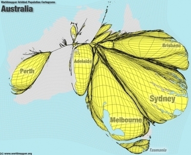

I found these cartograms from an article in the Telegraph and was immediately impressed. The cartograms originated here and use data from the Global Rural-Urban Mapping Project as to create the int...
This series of cartograms shows some imbalanced populations (such as the pictured Australia) by highlighting countries that have established forward capitals. Question to ponder: Do forward capitals change the demographic regions of a country significantly enough to justify moving the capital?


Interseting way to visualy map population density.
It's a creative and vial way to map population density.
This is from 'worldmapper' - it is a great sight to help you understand using technology the most densely populated areas of various countries. What do you think they are?