Stage 5 Changing Places
8.7K views | +0 today
Follow
Stage 5  Changing Places
Resources  linked to the NSW Geography Syllabus K - 10  
Curated by GTANSW & ACT
Your new post is loading...
Scooped by GTANSW & ACT
Scoop.it!

In Kenya, Using Tech To Put An 'Invisible' Slum On The Map

In Kenya, Using Tech To Put An 'Invisible' Slum On The Map | Stage 5  Changing Places | Scoop.it
A billion people worldwide live in slums, largely invisible to city services and governments — but not to satellites.
John Blunnie's curator insight, July 28, 2013 1:11 PM

Great how tech and globalization can help represed people in other countries.

Meagan Harpin's curator insight, October 6, 2013 5:07 PM

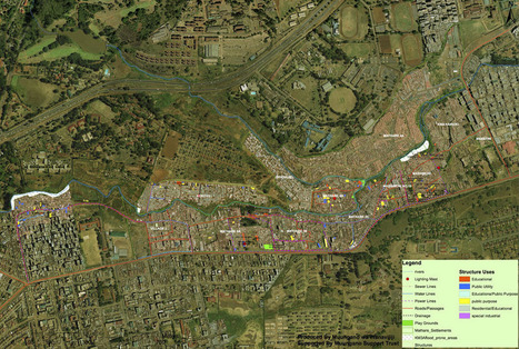
The slum-mapping movement began in India almost a decade ago and migrated to africa, the idea of this is to make slums a reality to people who have never set foot in one before. The maps can be used in court to stop evictions or simply to raise awarance. I think this idea is on the right track of what needs to be done. These people need help and so many people incuding the governement pretend they arent their but with these maps as proof they can no longer do that.    

Elizabeth Bitgood's curator insight, March 19, 2014 10:24 AM

Slums and squatter settlements are a problem that a lot of the developing world has to deal with.  The unsafe and unsanitary buildings cause headaches and problems for the leaders of the cities they surround.  This story is hopeful in that the city did manage to bring a water line out to get clean water to the people living in this area.  Perhaps this will lead to a better quality of life of the inhabitants of this particular slum.  Also the project of mapping such areas can be a useful tool for city planners to better regulate these areas and help the people that live there.,

Scooped by GTANSW & ACT
Scoop.it!

GIS and The City 2.0

GIS and The City 2.0 | Stage 5  Changing Places | Scoop.it

The City, for the first time in human history, houses more of our species than the countryside.  This fundamental fact means that geographers must study the city more.  GIS offers many of the tools needed for that type of sustained inquiry. Geospatial technologies are no longer only for the 'tech geeks,' researchers or even the tech saavy; GIS and other technologies are a learning platform for 21st century geo-literacy.  

No comment yet.
Scooped by GTANSW & ACT
Scoop.it!

The Rise of Megacities

The Rise of Megacities | Stage 5  Changing Places | Scoop.it
By 2025, the developing world will be home to 29 megacities.


Through this interactive mapping feature with rich call-out boxes, the reader can explore the latest UN estimates and forecasts on the growth of megacities (urban areas with over 10 million residents).  These 'cities on steroids' have been growing tremendously since the 1950s and present a unique set of geographic challenges and opportunities for their residents. 


Tags: urban, megacities.

Peter Steffan's curator insight, October 9, 2013 5:00 PM

Very cool!

Tori Denney's curator insight, May 27, 2015 3:36 PM

World cities and megacities - Presently , the mega cities of the world have to have a population of at least 10,000. Many cities are very near the minimum to be considered a mega city, but are not quite there. By 2025, the developing world, as we understand it now, is estimated to be home to 29 megacities.