

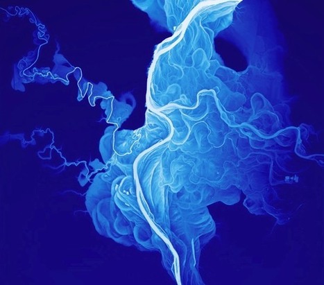

"If you measure the contours of a river valley with Lidar (like radar with lasers), you get a beautiful map of all the historical river channels."
Get Started for FREE
Sign up with Facebook Sign up with X
I don't have a Facebook or a X account


 Your new post is loading...
 Your new post is loading...
Your new post is loading...
"If you measure the contours of a river valley with Lidar (like radar with lasers), you get a beautiful map of all the historical river channels." 
No comment yet.
Sign up to comment
|

Sally Egan's curator insight,
December 7, 2014 4:27 PM
A very siual form using simple language to explain the meandering of rivers. Applicable to the course work on Hydrosphere. 
Jason Schneider's curator insight,
January 27, 2015 12:15 AM
So pretty much, the water controls rivers rather than particles controlling the river. Also, it appears that the motion and strength of the water causes rivers to bend and form in different curves. I'd like to think of it as a ball bouncing from side to side and every time it touches the border land of a river, it expands to the opposite side. However, when the water flow is hitting the side of a river, the opposite side is not getting any force from the water flow. In that case, the side that is not getting hit by the water flow slowly moves to the side that is being by the water flow causing river curves. 
GTANSW & ACT's curator insight,
June 1, 2015 2:07 AM
The geomorphic processes that produce landforms, including a case study of at least one landform
|


For the beauty of this picture. Follow the link to see the ancient courses of Mississippi River, I had once the idea to draw maps of the lower course of the Loue River in France not in a scientific purpose, but just for a kind of fractal art.