URBANmedias
75.1K views | +0 today
Follow
URBANmedias
le mediation des aménagements urbains
Your new post is loading...
Rescooped by association concert urbain from retail and design
Scoop.it!

The World's MOST Densely Populated CITIES

The World's MOST Densely Populated CITIES | URBANmedias | Scoop.it
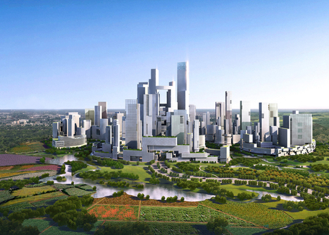
The growth of these cities will create a host of environmental and health problems.


By 2210, the global population is expected to grow from just more than 7 billion to 11.3 billion — with 87 percent of the population living in urban areas, according to a new working paper by researchers from NYU’s Marron Institute.

Most of these individuals will be in what’s now the developing world — creating a host of environmental and health problems.

If projections are correct, these new urban dwellers will require the world’s existing cities to expand six-fold to accommodate triple the residents, Richard Florida wrote in The Atlantic. Plus, the world will need 500 new “megacities” of 10 million or more, he wrote.


Via Lola Ripollés
Valerie Bauwens's curator insight, March 28, 2014 4:46 AM

Or will there be a natural come back to the country side?

Jessica Rieman's curator insight, April 2, 2014 5:42 PM

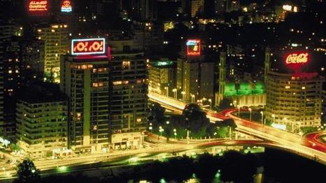
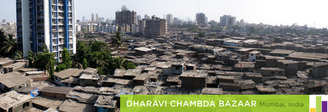
 Cairo, Egypt has a population density of 9,400 residents per square kilometer. THese numbers are crazy think about it compared to MA or RI and our major cities.

MsPerry's curator insight, August 12, 2014 8:03 PM

APHG-U2 & U6

Rescooped by association concert urbain from urbanism and urban governance
Scoop.it!

Megacities Reflect Growing Urbanization Trend

The capital of the South Asian country Bangladesh, Dhaka, has a population that is booming. However, it stands as one of the world's poorest mega-cities. This report comes from a GlobalPost series about the rise of mega-cities.


Via geofoodgraz
Jess Deady's curator insight, May 4, 2014 8:50 PM

To be a megacity like this, you have to conform to urbanization. There is no possible way to have such a populated and crowed city with farmlands around. This is a place of business yet residential areas, it also is where the marketplaces are and where kids go to school. Megacities need to be a part of an urban society in order for them to stay afloat.

Bec Seeto's curator insight, October 30, 2014 6:07 PM

This is a great introduction to the demographic explosion of the slums within megacities.  This is applicable to many themes within geography.   

Sarah Cannon's curator insight, December 14, 2015 10:20 AM

I can't image or even relate to the experience of living in a place like this. With rivers polluted right outside your house. And those rivers are what people bathe in and wash their clothes. I can't imagine not being able to access clean drinking water or lacking food. The people in Dhaka endure so much their whole lives, a good percentage of them will always live in poverty.

Scooped by association concert urbain
Scoop.it!

Public Transit and Density

Public Transit and Density | URBANmedias | Scoop.it
Imran Ahmed Khan's comment, January 17, 2013 3:44 PM
Good picture! It defines the growth of the city that impact on urbanization rate, public health, socioeconomic environment. It also tell us that if we reduce vehicles on the road more space and clean environment may we get, that reduce motality and morbadity of several disease especially lung diseases.
Lauren Jacquez's curator insight, April 8, 2013 9:31 PM

What are the benefits for each?  Drawbacks? You decide!

Rescooped by association concert urbain from Transition * L'impossible n'est que temporaire
Scoop.it!

Brève histoire de la densité urbaine & 5 idées pour l'avenir (vidéo)

Brève histoire de la densité urbaine & 5 idées pour l'avenir (vidéo) | URBANmedias | Scoop.it

En un quart d'heure, Kent Larson, architecte et directeur du programme Home_n au MIT, pionnier de l'architecture open source, brosse une histoire de la densité urbaine et la prolonge par un prospective autour de cinq concepts innovants. La vidéo étant à la fois dense et intéressante. Elle rassemble des tendances très actuelles et les illustre avec des exemples concrets. Je vous propose de la regarder ou de lire le petit compte rendu ci-dessous.


Via Nathalie
No comment yet.
Scooped by association concert urbain
Scoop.it!

Comparing URBAN Footprints

Comparing URBAN Footprints | URBANmedias | Scoop.it

"This is a series of infographics (or geo-infographics) created by Matthew Hartzell, a friend of mine that I met when we were both geography graduate students at Penn State in few years back..."

Jacob Crowell's curator insight, October 14, 2014 3:25 PM

This is an interesting way to graph out the urban footprints of various cities from around the world. This also shows how the United States has a number of the largest urban centers in the world. Along the top, New York, Chicago, LA, and Miami are massive compared to cities like Hong Kong. This shows how in the United States there are massive amounts of urban growth. Even in China where their population is one of the worlds biggest, Hong Kong a major city only has 7.1 million. In the United States, for the past century cities have been growing and this graph shows that.

Samuel D'Amore's curator insight, December 14, 2014 6:40 PM

These visuals really help to show that the size of a city doesn't necessarily correspond with it's population. Many years ago the trend was the larger the city in turn it would posses a larger population than a physically smaller city. Today this no longer holds true, in fact many smaller cities vastly out populate large sprawling cities. Most of these mega-cities in Asia and Latin America are incredibly over build and densely packed surrounded by miles of slums. 

Edgar Manasseh Jr.'s curator insight, January 22, 2015 7:16 PM

Pretty cool.


Rescooped by association concert urbain from Développement social et culturel de territoires
Scoop.it!

Get a Bird's-Eye View of America's Housing Patterns

Get a Bird's-Eye View of America's Housing Patterns | URBANmedias | Scoop.it
See the big picture of how suburban developments are changing the country's landscape, with aerial photos and ideas for the future

Via Apres
Liam Michelsohn's curator insight, December 10, 2013 4:13 PM

A very interesting article on changes in landscape, while looking though this I came aross so many little things i never noticed about the topical layout of housing. The main thing that is apparent is density, how closely each house is put together, the amount of land each has as well as the view from the property. Its aslo interesting to see how the design of the area can be made for easy access or be desigend to keep people out with only one enctancte and exit. All of these charasticts make up how the land is desired as well as econimcly priced, which then determins who will be able to live there.

Jacqueline Landry's curator insight, December 15, 2013 8:53 PM

Having the streets interconnected allows for easy  traveling throughout the area.  when there is more density in an area it means there are more houses , more people.  The sprawl has the center on the place and the streets go out around it. The way the streets are made are for different reasons,.

megan b clement's comment, December 16, 2013 12:57 AM
This article talks about twenty different housing patterns and how we base these housing patterns around our society or enviroment. How looking at housing patterns can tell you what kind of neighborhood one lives in from the sky. Looking down and seeing a golf course with lush grass and big backyards shows you that this neighborhood is very expensive. Or Canal houses that utilize every inch of the waters edge to financially make them able to charge higher prices for the homes because each house has a water view and is on the waters edge.
Rescooped by association concert urbain from green streets
Scoop.it!

Sustainable Urbanism: a high-density, car-free vertical city in Chengdu, China

Sustainable Urbanism: a high-density, car-free vertical city in Chengdu, China | URBANmedias | Scoop.it
Work is about to start on a high-density, car-free "satellite city" for 80,000 people close to Chengdu in China.


Designed by Chicago firm Adrian Smith + Gordon Gill Architecture, the 1.3 square km 'Great City' will feature a high-rise core surrounded by a buffer landscape of open space (60% of the total area). Residents will be able to walk from the city center to its edge in just 10 minutes.

“The design is attempting to address some of the most pressing urban issues of our time,” said architect Gordon Gill. “We’ve designed this project as a dense vertical city that acknowledges and in fact embraces the surrounding landscape.”

“The sustainability framework for Great City, custom-designed based on the principles of LEED-ND and BREEAM, follows an integrated approach toward meeting the overall objectives of environmental, economic and social sustainability,” notes Peter J. Kindel, AIA, ASLA, AS+GG’s Director of Urban Design. “Great City will incorporate innovative technologies and infrastructure systems to achieve 48% energy savings of a conventional urban development.”


The architects also note that the city will use 48% less energy and 58% less water than conventional developments of this size, producing 89% less landfill waste and generating 60% less carbon dioxide...


Via Lauren Moss
No comment yet.
Rescooped by association concert urbain from Landscape Urbanism
Scoop.it!

The DENSITY Atlas

The DENSITY Atlas | URBANmedias | Scoop.it

The Density Atlas is a planning, design and development resource for comparing urban densities around the world. The Atlas features a unique metrics and scale system for a comprehensive understanding of urban density.


Via Ignacio López Busón
No comment yet.