omnia mea mecum fero
14.2K views | +0 today
Follow
omnia mea mecum fero
όλα τα δικά μου τα κουβαλάω πάνω μου
Curated by pa3geo
Your new post is loading...
Rescooped by pa3geo from visual data
Scoop.it!

Infographic: Hackers Create An Amazing, Illegal Portrait Of The Internet

Infographic: Hackers Create An Amazing, Illegal Portrait Of The Internet | omnia mea mecum fero | Scoop.it

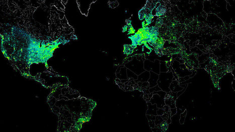
It wasn’t malicious. The file itself was the size of a small JPEG. It was given the absolute lowest priority. And it was set to self-destruct if anything went wrong. But this small file allowed one single hacker to measure the Internet activity of nearly half a million connected devices around the world, then share the results with everyone.

How was this even possible? The "hacker" barely hacked anything. In reality, they gained access to all these systems because each had the default "root" set as a password. With this access in hand, they ran several tests focusing on Internet structure and activity. And what they created from all this data is a spectacular map that captures a day in the life of the Internet (and all of its users).


Via Lauren Moss
Annenkov's comment, May 10, 2013 11:24 PM
США и Европа как очаги информатизации
Sakis Koukouvis's comment, May 11, 2013 3:17 AM
Wonderful
Nacho Vega's curator insight, May 11, 2013 12:18 PM

Creative power: hacking at the end of the world!


Using "root" as universal key :))

Rescooped by pa3geo from Just like every drop of rain...
Scoop.it!

Interactive World Statistics

Interactive World Statistics | omnia mea mecum fero | Scoop.it

The Brazilian government's geographic department (Instituto Brasileiro de Geografia e Estatística-roughly equivalent to the U.S. Census Bureau) has compiled an fantastic interactive world factbook (available in English and Spanish as well as Portuguese).  The ease of navigation allows the user to conduct a specific search of simply explore demographic, economic, environmental and development data on any country in the world.    


Via sofilab
No comment yet.
Rescooped by pa3geo from Science News
Scoop.it!

[VIDEO] 3D city models - automated processes

To enable as many cities as possible to have their own 3D city model, the specialists from 3D Reality Maps, perfected the next generation of high resolution 3D landscape models, and the technology for 3D modeling of cities.

Via Sakis Koukouvis
No comment yet.
Rescooped by pa3geo from visual data
Scoop.it!

Infographic: An Amazing, Invisible Truth About Wikipedia

Infographic: An Amazing, Invisible Truth About Wikipedia | omnia mea mecum fero | Scoop.it

Every Wikipedia entry has an optional feature we take for granted--geotagging. An entry on the Lincoln Memorial will be linked to its specific latitude and longitude in Washington D.C. On any individual post, this may or may not be a useful thing. But what about looking at these locations en masse?

That was a question asked by data viz specialist and programmer Olivier Beauchesne. To find out, he downloaded all of Wikipedia (it’s open-source, after all) then used an algorithm that would assemble 300 topical clusters from popular, related keywords. Then he placed the location of each article in these topical clusters on a map. What he found was astounding...


Via Lauren Moss
No comment yet.
Rescooped by pa3geo from visual data
Scoop.it!

How Google Builds Its Maps—and What It Means for the Future of Everything

How Google Builds Its Maps—and What It Means for the Future of Everything | omnia mea mecum fero | Scoop.it
An exclusive look inside Ground Truth, the secretive program to build the world's best accurate maps.


Behind every Google Map, there is a much more complex map that's the key to queries but hidden from view. The deep map contains the logic of places: their no-left-turns and freeway on-ramps, speed limits and traffic conditions. This is the data that Google uses to navigate you from point A to point B.

Last week, Google showed me the internal map and demonstrated how it was built- the first time the company has let anyone see how the project it calls GT, or "Ground Truth," actually works.

Google opened up at a key moment in its evolution. The company began as an online search company, but then the mobile world exploded. Now, where you're searching from has become almost as important as what you're searching for. Google responded by creating an operating system, brand, and ecosystem that has become the only significant rival to Apple's iOS.

And for good reason. If Google's mission is to organize all the world's information, the most important challenge -- far larger than indexing the web -- is to take the world's physical information and make it accessible and useful...


Read the entire article for a fascinating look at how Google utilizes mapping systems, geo data, mobile technology, and visual representation to manage massive amounts of data from varying sources, including one of the most important to the success of Google Maps- human intelligence.


Via Lauren Moss
No comment yet.
Rescooped by pa3geo from Science News
Scoop.it!

Ordering the Heavens: A Visual History of Mapping the Universe

Ordering the Heavens: A Visual History of Mapping the Universe | omnia mea mecum fero | Scoop.it
From Copernicus to Ancient Korea, or what the Chinese concept of change has to do with Aztec astrology.

Via Sakis Koukouvis
No comment yet.