Your new post is loading...

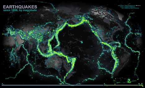

This map of all the world's recorded earthquakes between 1898 and 2003 is stunning. As you might expect, it also creates a brilliant outline of the plates of the Earth's crust—especially the infamous "Ring of Fire" around the Pacific Plate.
The plate boundaries are amazingly vivid in this geovisualization of the all the earthquakes over a 105 year span. How did scientist orginally come up with the theory of plate tectonics? How did spatial thinking and mapping play a role in that scientific endeavor?
Via Martin Daumiller, Sakis Koukouvis