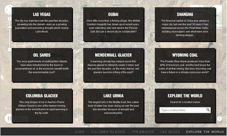

Exclusive timelapse: See climate change, deforestation and urban sprawl unfold as Earth evolves over 30 years.
Get Started for FREE
Sign up with Facebook Sign up with X
I don't have a Facebook or a X account


|
Scooped by
Adrian Bahan (MNPS)
onto UNIT I APHuG |
Exclusive timelapse: See climate change, deforestation and urban sprawl unfold as Earth evolves over 30 years.


 Your new post is loading...
 Your new post is loading...
Your new post is loading...
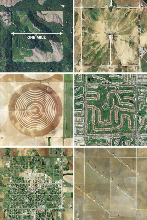
"The images here, taken from the Instagram account @the.jefferson.grid show just a few of the landscapes that can be squeezed into the one-mile squares. The idea behind this sprawling checkerboard emerged after the Revolutionary War. As the United States expanded westward, the country needed a systematic way to divide its newly acquired lands. The original colonies were surveyed using the British system of 'metes and bounds,' with parcels delineated using local geography.
That approach doesn’t scale very well, and Jefferson proposed to slice the young United States into gridded plots of land. Jefferson's idea became a reality in 1785 when it was enacted as the Public Land Survey System. Today his grid covers much of the country, and it is still used to survey federal lands — an idea that shaped the physical landscape of half a continent."
Tags: images, land use, landscape, social media, planning, spatial, scale, historical.

Dyna-e International's curator insight,
September 1, 2015 12:32 PM
No such thing as being off the grid really. ~ Ron Sandack

Explore the popularity of some of the world’s favourite foods on Instagram. Discover Instagram’s capital of curry, which cities are big on burgers, and where pulled pork is most prolific.
Visualizing everything from the spread of religion to the most racially tolerant countries to the world's writing systems.
"Geography. It lets you study the world. No, really, THE WORLD. Think about that. What other subject deals with rocks? Moving continents? AND climate? Diffusion of plants and animals? Water quality? Now, what if you add some human systems--do the other sciences let you relate the earth to economic or political systems? And culture--food, religion, music, housing, or language? How about urban systems and settlement forms? Past, present, and future, anywhere in the world? And how many subject areas let you look at something from a scientific, social-scientific, humanistic, AND artistic perspective? Yeah, I said artistic--I like to illustrate my findings with a nice map.

Emily Bian's curator insight,
October 3, 2014 5:20 PM
This scoop caught my eye because of all the cartoons and memes. Some of them are pretty funny geography puns, and I'm sure other people will enjoy this. There is world and human geography, and I have already learned world geography. World Geography has already helped me learn a lot about the world around me. Before, I was very illiterate in maps, but now I'm pretty decent. I can't wait to learn more in human geography! 1) geography as a field of inquiry It's a FB page of geography and it basically spreads the topic of geography, which is increasing in awareness. I think everybody should learn world geo and human geo is a good elective to take. 
Colleen Blankenship's curator insight,
March 28, 8:51 PM
Studying geography, especially AP Human Geography means studying everything! Look to see all the components as they reveal themselves as we study!
Full album & lyrics: http://www.marblesthebrainstore.com/brain-beats-2 Music by Renald Francoeur, Drawing by Craighton Berman, Video by Don Markus "Tour the ...

Emma Boyle's curator insight,
November 20, 2013 8:28 AM
The chorus gets a little old, but I dare you not to like this video.
The map, as an innovation, is extremely important. Simply constructing a useful representation of our world onto a piece of paper (or clay or vellum or whate...
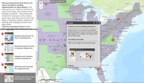
"Did you know know that there are some excellent reading opportunities in Story Maps? This map serves as a table of contents for using Story Maps with Common Core Reading Standards. Reinventing the wheel isn't necessary with so many great maps and data sources that will help us teaching reading, writing and thinking with engaging content and little effort."
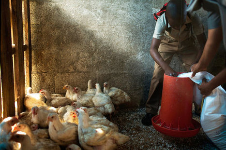
"The country has taken on a bold new strategy in the face of expensive food imports: make farming patriotic and ubiquitous."

Matthew DiLuglio's curator insight,
November 27, 2013 4:34 PM
I have discussed Jamaica with some former classmates of mine, and they informed me that a lot of people are really poor there. They said that the people there were very friendly, and hooked my friends up with some outstanding agricultural products at a really good price, but these people are very poor. I think that because Jamaica was involved in the slave trade, and they didn't really as much of have slaves to do work like the US, but Jamaica was still involved in the slave trade, which ensured the presence of slaves. While the US was building as a country, Jamaica was not thriving as much. I think that the agriculture in Jamaica is (by what my friends say) fabulous as far as illegal crops go, but the agriculture FOR the Jamaicans (such as food) is lacking. I read in the article that a European Development Agency sent money to Jamaica to help them be able to build chicken coops... So the chickens are enslaved too, and doomed to lay eggs or become a Sunday dinner. That is kind of sad. In all truth, I enjoy the taste of meat, but look forward to when meat and plants will be synthesized with no living tissue involved, because, after all, plants are alive too. There are so many things that people have taken from the Earth, without giving anything back. We are approaching the era where people should be more concerned with the environment, and what they can do for the Earth. I think Jamaica should be given new technology that serves synthetic meat and synthetic vegetables, as a way to aid their agricultural and economic situation, rather than money for chicken coops from some pompous European cults. 
Nathan Chasse's curator insight,
February 8, 2014 1:53 PM
The article describes how Jamaica and a couple other Caribbean nations are beginning to focus more on food crops than cash crops. Being dependent on imports for food can be disastrous for these islands when a global food shortage makes prices skyrocket. Being food independent will likely allow Jamaica to increase its net agricultural gains so long as the production and demand for its cash crops of bananas and sugarcane remain high.

Jess Deady's curator insight,
February 18, 2014 12:56 PM
Understanding how other countries survive their everyday lives is an important part of being a civil human being. As shown in one of the clips, a boy is putting on a tie before school and is on his way to eat breakfast. Not only does he have to eat breakfast at home, but he also is eating a stew that he picked the crops for. I could never imagine picking my own food in order to survive life. This scoop is enlightening in many ways.
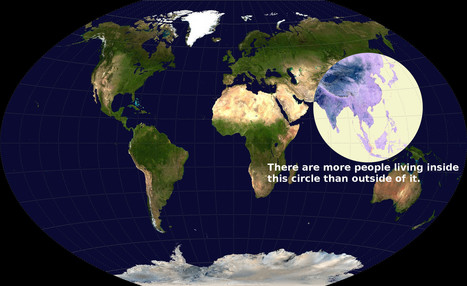
This is a fabulous map---but is the statement true?

Matt Ramsdell's curator insight,
December 14, 2015 2:25 PM
After analyzing this map and looking at the busiest cities and countries in the world I believe this statement to be true. China a giant and very populated country, India is also within the top ten and so is Japan. Once all these have been looked at you can clearly tell that this area of the world is easily the most populated. Many of the other countries and nations have large swaths of land that are very lightly populated. This is a robust area of the world and in some cases the most expansive. 
Adam Deneault's curator insight,
December 14, 2015 6:33 PM
It surprises me how many people live in just that one circle! it is hard to believe or probably explain to someone that with all the other space in the world, that the circles region has more people in it than what is not circled. Although, it could be validated by more reliable or more sources, because with the world that we live in now, numbers can easily be forged. I do believe though that 51% of the world's population does live here.

Alex Vielman's curator insight,
December 14, 2015 11:58 PM
This is perhaps the most intriguing map I've been able to analyze. Could it be possible that more people live in that circle than out of it? The world is HUGE and to think the majority of the population resides here, is truly incredible. India, has a huge population living in there for such a small area. Currently, India has over 1 billion people living there making it the second most populous country before China with 1.3 billion. China has a bigger surface area than India and it is interesting to know how these areas compare. The important issue with India is the fact that, with so many people, there is a lack of housing and sanitation unavailable to provide to so many people. The facts are giving that India suffers from overpopulation, clearly, this image has to be true.
View Full Lesson on TED-ED BETA: http://ed.ted.com/lessons/how-pandemics-spread In our increasingly globalized world, a single infected person can board a pl...
This is a great demonstration of why spatial thinking is critical to so many fields, including medicine.
Tags: diffusion, medical, historical, spatial. Via Matthew Wahl

Miles Gibson's curator insight,
November 23, 2014 11:33 AM
Unit 1 nature and perspectives of geography This video is about how a world wide pandemic can occur and has occurred in history. I thought this was interesting because it spoke of many specific events like the black death and the 2010 cholera outbreak in haiti, gave detailed information, and was very informal. This relates to unit 1 because it shows how pandemics and epidemics occur in a detailed way. It also shows how geography has related to epidemic outbreaks by showing disease spread maps and showing how doctors used this to solve the issue of it. |
This site is used to highlight the distortion issues caused by the Mercator map projection. It can be used to show the true size of countries How it Works 1. Enter a country or state name 2. Hover over selection for size information 3. Click on selection to drag 4. Right-click on selection to delete
Tags: mapping, visualization, map projections, cartography, perspective.
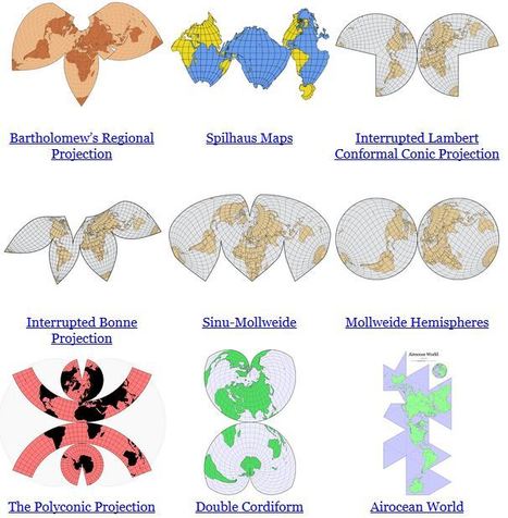
"In some ways, all 2D maps of Earth are interrupted at some point, even if it’s just along the antimeridian at 180°. Interruptions are often in areas of less interest e.g. oceans for a land-focused map."

Alex Smiga's curator insight,
September 7, 2015 4:23 PM
Seth Dixon's insight:
No screenshot could do justice to this animation. It transforms a map of the world from one map projection to another, and in the 5 second interval it 'spins the globe' to give you a sense of the the spatial distortions inherent in all projections. This is but one of the many visualizations fromJason Davies mapping project. 
Vincent Lahondère's curator insight,
January 4, 2018 5:42 PM
Un site qui permet de visualiser les principales projections cartographiques
"Data is great, but working with numbers can be intimidating. We have more data than ever before that is available to us, and graphs, charts, and spreadsheets are ways that data can be shared. If that data has a spatial element to it, the best way to visualize a large dataset might just be a map."
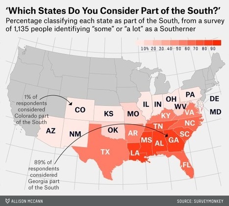
"The Southerners were considerably more certain of which states are their own. While the top few Midwest states barely pulled 80 percent of the vote, nearly 90 percent of respondents identified Georgia and Alabama as Southern, and more than 80 percent placed Mississippi and Louisiana in the South. South Carolina, Tennessee, Florida and North Carolina all garnered above 60 percent."

Wilmine Merlain's curator insight,
November 1, 2014 10:40 PM
When I think of states that constitute as being a part of southern United States, I think of VA, NC, SC, GA, MS, AL, LA, TX, and FL. I never thought of KY as being a state a part of the south. Although its geographical location demonstrate it being relatively close to being in the south, I always thought of KY being a Midwest because of the weather similarities with states that are located in the Midwest.
Miles Gibson's curator insight,
November 22, 2014 8:08 PM
Unit 1 nature and perspective of geography This map is a map of the p.o.v. of a surveyed group stating what they think the south is. They answered with suprising accuracy overall with some outliers. This map shows the stereotypes of the area that people deem it. This relates to unit 1 because it shows a perceptual map of an area that isn't truly defined. This is a perceptual map because of its undefined borders and a level of accuracy at the personal level.
Adam Deneault's curator insight,
December 4, 2015 9:37 PM
As someone who had a summer home in Orlando, Florida, and having friends and family there too, we would occasionally have the discussion what we considered the South. For myself, I always had the idea that the south was from North Carolina to Florida and from Florida as far west as Texas. As for the deep south, I would consider Alabama, Georgia and Florida to be the deep south. I have a friend currently stationed at Camp Lejeune in North Carolina and he considers NC and anything under to be the South.
Maps don’t just tell you which street to turn left on. Maps convey information that shapes our lives, deepen our understanding of problems and our ability to create solutions, and whisk our imaginations to new lands. Via Thomas Forsgren
If you're a visual learner like myself, then you know maps, charts and infographics can really help bring data and information to life. Maps can make a point resonate with readers and this c... Via Ryan LaHayne
Miles Gibson's curator insight,
November 23, 2014 11:51 AM
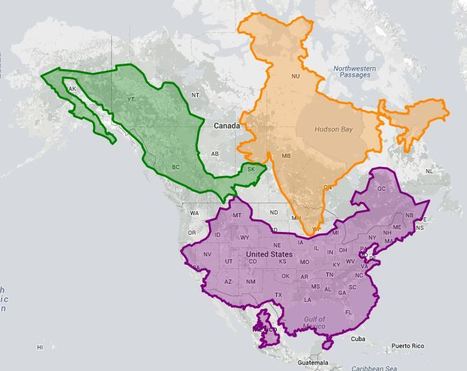
Unit 1 nature and perspectives These maps listed are maps showing the world in different ways to show how the size of the countries are actually in comparison to each other. It also makes a good repesentation of the location of the countries in a relative distance. This relates to unit 1 because it shows the parts of the world in a type of reference map and generally explains the world's parts, which is a major part of unit 1. It also shows scale and place in this map. This is a difinitive part of unit 1.
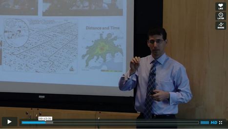
Seth Dixon, a Rhode Island College geography professor and the coordinator of the RI Geography Education Alliance, gave the keynote address at the Thinking Geographically about International Issues 2013 summer institute, in a talk entitled What Does Good Geography Teaching Look Like?

GTANSW & ACT's curator insight,
August 31, 2013 2:25 AM
This is a great video and sa reminder of how we should be approaching our teaching of the Australian Curriculum. 
Jarrod Dodds's curator insight,
April 13, 2014 8:49 PM
In this video, Seth Dixon demonstrates a profound knowledge of geographical concepts . More importantly, it's his delivery and approach to teaching those concepts.
Watch this video and respond to the questions.
1) Highlight what methods the professor uses to engage students effectively.
2) Why do you think those methods are important, particularly for the subject of geography?
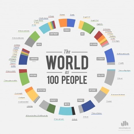
"Infographics to explain global statistics."

Leoncio Lopez-Ocon's curator insight,
August 27, 2013 3:49 PM
Un conjunto de sencillas infografias para visualizar estadisticas de la humanidad en el tiempo presente 
Sid McIntyre-DeLaMelena's curator insight,
May 29, 2014 12:11 PM
If the World was 100 People shows the statistics of the world as in smaller proportions allowing them to be easily visualized. Some of the graphics divide the people into regions and nationalities mainly as Formal by continents .
Exclusive timelapse: See climate change, deforestation and urban sprawl unfold as Earth evolves over 30 years.

Ishola Adebayo's comment,
July 31, 2013 9:07 AM
good day Sir, pls need help on fixing scan line errors on lansat7 ETM images from 2003 using for example ArcMap9.3 or ENVI4.5 or.........thank you so much

Courtney Barrowman's curator insight,
May 27, 2015 10:55 AM
summer work KQ2 key concepts: remote sensing, deforestation, desertification, land use, geospatial
Adrian Bahan (MNPS)'s insight:
I need to show this Day 1 of next school year
From the NY TImes "We have created 10 activities for teaching about geography using Times content, all related to the National Geography Standards." Carla Saunders originally scooped this on "History and Geography in the 21st Century Classroom." GENIP recently released (via NCGE) the second edition of "Geography for Life"--the National Geography Standards. Here are some interesting activities using Times articles. I am a fan of the NY Times Learning Network--you can get great ideas here! Via Carla Saunders, Jamie Strickland, Matthew Wahl
|


Exciting!!
summer work KQ2 key concepts: remote sensing, deforestation, desertification, land use, geospatial