

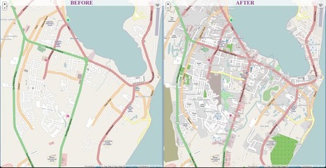

Volunteers across the world are building the digital infrastructure for the organization's Typhoon Haiyan relief efforts
Get Started for FREE
Sign up with Facebook Sign up with X
I don't have a Facebook or a X account


 Your new post is loading...
 Your new post is loading...
Your new post is loading...
Volunteers across the world are building the digital infrastructure for the organization's Typhoon Haiyan relief efforts 
|


online maps are being used to help locate the best way possible to help transport food and resources to those most in need. They van locate bridges and the world is pulling together with tehcnolgy and accurate maps to help the American red Cross maximize in time and manpower. It seems that after Hurricane Katrina and the Earthquakes in Haiti and Japan, We have been improving our strategies for how to best help people around the globe come together put our time energy and resources together to best help people whose lives have been devasted and crushed by the forces of mother nature.
Having a map of the current landscape, after the typhoon will speed up relief and rescue efforts by showing areas to land and set up help stations. The digital world is immediate now and this will change how organizations such as the Red Cross provide relief to suffering people.