The artistic collection entitled 'Landscapes' compiled "the bizarre instances of cartographic dissonance inflicted by the Dutch government over their virtual lands. As Henner notes, the number of censored sites within the small country of the Netherlands is surprising, as is the technique used by officials to disguise them. Tracts of land deemed vulnerable to attack or misappropriation are transformed into large tapestries of multi-colored polygons, archipelagos of abstraction floating in swaths of open fields, dense forests, and clusters of urban development." See the original gallery here: http://mishka.lockandhenner.com/blog/?p=574
Research and publish the best content.
Get Started for FREE
Sign up with Facebook Sign up with X
I don't have a Facebook or a X account
Already have an account: Login
 Your new post is loading... Your new post is loading...
 Your new post is loading... Your new post is loading...

olsen jay nelson's comment,
August 16, 2012 7:46 AM
This is just what I've been looking for, believe it or not:-)

Paul Rymsza's comment,
August 22, 2012 2:15 PM
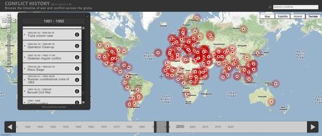
the potential of this site is amazing between the interactive learning system and the correlation between the timeline and location. If the human geography class is anything like this i can't wait for it!
|
benjamin costello's curator insight,
May 20, 2015 5:38 PM
Interesting concept but not totally fleshed out for use by historians... genealogists perhaps would have a better or easier time using this program. It is very interesting but it only allows for one movement, so rather than showing the history of a nation you can show the history of a family through its interactive timelines. Google maps is not always accurate as well. |


