MAZAMORRA en morada
22.5K views | +0 today
Follow
MAZAMORRA en morada
Una colección de materiales heterogéneos que sólo tienen en común el suscitar el interés del compilador y de los lectores que presuntamente van a interesarse, mezclando opiniones, informaciones y curiosidades...
Curated by parislima
Your new post is loading...
Scooped by parislima
Scoop.it!

Cartographic ANOMALIES: How Map Projections Have Shaped Our Perceptions of the World

Cartographic ANOMALIES: How Map Projections Have Shaped Our Perceptions of the World | MAZAMORRA en morada | Scoop.it

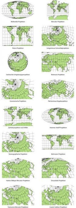
Elizabeth Borneman explores how cartography and cartographic projections help and hinder our perception of the world.

"How do you think the world (starting with our perceptions) could change if the map looked differently? What if Australia was on top and the hemispheres switched? By changing how we look at a map we truly can begin to explore and change our assumptions about the world we live in."


Geography doesn’t just teach us about the Earth; it provides ways for thinking about the Earth that shapes how we see the world.  Maps do the same; they represent a version of reality and that influences how we think about places. 


Tags: mapping, perspective.

samantha benitez's curator insight, November 22, 2014 2:53 PM

helps show the different perspectives of our world and how it has changed. also shows many different forms of mapping our world throughout time.

Emily Coats's curator insight, May 27, 2015 10:34 AM

UNIT 1 

This article discusses map projections and how they shape our perception of the world. Maps influence how we see the world, and could change the way we see it as well. These projections show us many different views of the Earth, which is very influential to our perspectives. This applies to unit 1 and its major concepts and underlying geographical perspective such as analyzing maps. 

Vicki S Albritton's curator insight, August 26, 2016 8:35 PM
What we see isn't always what is.
Scooped by parislima
Scoop.it!

Maps of the Future

Maps of the Future | MAZAMORRA en morada | Scoop.it
A 1989 prediction about portable GPS devices was right on the money...


As technology continues to speed ahead, how we interact with maps will keep evolving.  This is a thoughtful blog post that spectulates about the future of mapping. 

No comment yet.
Scooped by parislima
Scoop.it!

40 Maps That EXPLAIN The Middle East

40 Maps That EXPLAIN The Middle East | MAZAMORRA en morada | Scoop.it
These maps are crucial for understanding the region's history, its present, and some of the most important stories there today.
Alex Vielman's curator insight, November 23, 2015 3:17 PM

Maps like the ones posted in this article, really helps people to understand and break down deeply of understanding the entire region as a whole. Visualization is very important in geography when trying to understand the region people are talking about. this region as goes down to the Mesopotamia Era. It is important to know, how the culture was in this area to how it differentiated during the Ottoman Empire. During the first couple of maps, we can begin to see the division of the entire region. As you go on, we begin to notice the divisions between people, religion, language between states and in-states. There is so much information to know about the Middle East region and it may be even harder to understand due to the tons of changes and separations, but it is important to understand these divisions like the Sunni's and the Shi'ites in order to fully explain the development and the current situations that are occurring in this region as we speak. 

Matt Ramsdell's curator insight, December 7, 2015 5:18 PM

These 40 maps are a very interesting way of showing how people have traveled around and moved about the Earth from the time of the fertile crescent era to the people of today. It shows us the paths that people have taken to move to a new location. How they used the Meditteranean Sea to move from one side to the other. It also shows how the Tigris and Euphrates came together to form a smaller area of the Persian gulf. This led to smalled economic growth because now there is less land for imports and exports.

Kelvis Hernandez's curator insight, December 12, 2018 10:49 PM
Being able to explain any region in just 40 maps is a very bold claim. While no one would be able to do this Vox was able to make a very interesting set of historically, culturally, and politically themed visualizations of this continuously changing part of the world. Some maps show the borders of an empire past, others discuss the many ethnic groups that call the region their home, and yet another discusses the importance of oil and who has it.