

"49 Maps That Explain The U.S. For Dumb Foreigners--The United States is mind-boggling. Right?!"
Get Started for FREE
Sign up with Facebook Sign up with X
I don't have a Facebook or a X account


 Your new post is loading...
 Your new post is loading...
Your new post is loading...
"49 Maps That Explain The U.S. For Dumb Foreigners--The United States is mind-boggling. Right?!" 
|


It's to see these "maps" that "explain" the U.S. in almost a sarcastic matter. Americans are living in what researches call megaregions. After, doing our Map of the U.S. for an assignment, it becomes difficult to divide regions when one is so familiar with one area, in my case, New England. New England, or the Northeast, is considered a megaregion because there is high population density in this area. In the map that displays these megaregions, its interesting to see those areas that are emerging. For example, in the map it saids Cascadia is emegering which is the corner of the U.S., the state of Washington.
Some people think that the U.S. population is spread throughout the whole map. Its interesting to actually realize that 47% of the U.S. has zero population. This was an awesome article thats loaded with fun interesting facts.
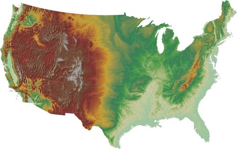
Understanding the landscape of our Country is important. The way to best understand it is to look at maps, especially these maps, and get a hold on what the country looks like. From the height of exploration to seeing where the most trees are within the country. This map has a lot of information for anyone who has questions.