Merveilles - Marvels
29.3K views | +0 today
Follow
Merveilles - Marvels
Cabinet des curiosités, coups de coeurs, trouvailles probables ou improbables, très très loin ou tout près, produites par la main de l'homme ou par la nature...
Curated by Alcofribas
Your new post is loading...
Scooped by Alcofribas
Scoop.it!

Handkerchief Maps

Handkerchief Maps | Merveilles - Marvels | Scoop.it

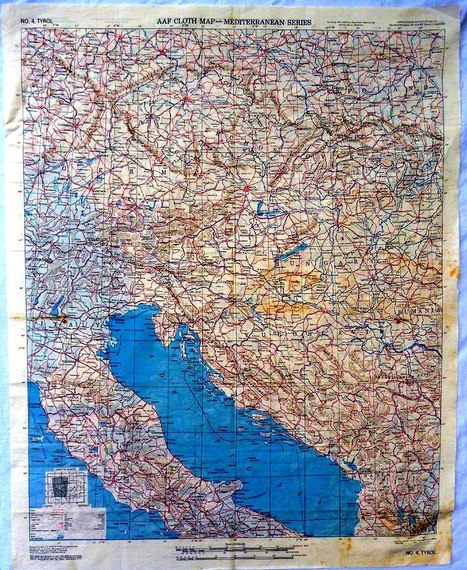
I have three half-metre-square maps of southern Europe framed on my living-room wall. Printed by the American air force on acetate rayon – lightweight, waterproof and hard to tear – the ‘handkerchief maps’ were given to my father-in-law, Howard Walker, who flew with the Australian Air Force during the Second World War. He started operational flying from Brindisi in October 1944, in Lancaster bombers that dropped supplies – guns, explosives, food and clothing – for partisans in northern Italy, Yugoslavia and northern Greece. ‘My job,’ he says, ‘was to ride up in the perspex nose of the plane to pick out landmarks of any sort that would help the navigator affirm or correct the plane’s course.’...


No comment yet.
Scooped by Alcofribas
Scoop.it!

Le tour du monde avec la BNF

Le tour du monde avec la BNF | Merveilles - Marvels | Scoop.it

Comment les grands navigateurs, au XIV ème siècle, se représentaient ils la planète? Avec quels instruments se lançaient ils sur les océans? Comment transcrivaient ils leurs découvertes? L'exposition de la BNF, "L'âge d'or des cartes marines, quand l'Europe découvrait le monde", répond à toutes ces questions et à bien d'autres. A la fois savante et didactique, elle aborde de nombreuses thématiques _le rôle des cartes, les grandes découvertes, l'hégémonie européenne, la création d'une iconographie des Nouveaux Mondes.._ à travers une sélection de 80 des plus belles cartes portulans du monde, et une centaine de pièces rares, globes, instruments astronomiques, objets d'art et d'ethnographie, dessins, estampes, manuscrits, rassemblés pour la première fois dans une scénographie très travaillée. Le jeune public est très attendu pour ce tour du monde: un parcours-jeu est proposé aux  8-12 ans et de nombreux ateliers sont  organisés, jusqu'à la fin de l'année scolaire pour les élèves, du CE2 à la Terminale...

No comment yet.
Scooped by Alcofribas
Scoop.it!

The True Size Of Africa

The True Size Of Africa | Merveilles - Marvels | Scoop.it

This is another old classic image that I might have shared earlier but it merits repeating. As Salvatore Natoli (a leader in geography education) once said, "In our society we unconsciously equate size with importance and even power." This is one reason why many people have underestimated the true size of Africa relative to places that they view as more important or more powerful...

Afrikasources's curator insight, January 15, 2014 10:10 AM

Just a reminder

Maria la del Varrio's curator insight, December 5, 2014 11:01 AM

It is incredible big, but unfortunately most of the north area is cover by the big Sahara and most of the are is typically unfertilized. 

Jason Schneider's curator insight, March 9, 2015 4:29 PM

As we can see, there's a little overlapping here and some empty spots but it's pretty accurate. The United States and China are in the top 5 largest countries of the world list and they still fit in the 2nd largest continent of the world, Africa. I'd like to see the size comparison between Africa and Russia. I did some research on that and it turns out that Russia is a little over half the size of Africa, maybe the size of the combination of the United States and China.

Scooped by Alcofribas
Scoop.it!

Interactive Earth at Night

Interactive Earth at Night | Merveilles - Marvels | Scoop.it
Rescooped by Alcofribas from Kiosque du monde : A la une
Scoop.it!

Exposition « L’Âge d’or des cartes marines » | Bibliothèque nationale de France

Exposition « L’Âge d’or des cartes marines » | Bibliothèque nationale de France | Merveilles - Marvels | Scoop.it

Des premières images de la Méditerranée aux planisphères nautiques, l'exposition retrace l'histoire des cartes marines et montre comment elles ont accompagné les grandes étapes de la découverte du monde...


Via musée du quai Branly - Jacques Chirac
No comment yet.