Machines Pensantes
48.2K views | +0 today
Follow
Machines Pensantes
La vie sous toutes ses formes
Your new post is loading...
Scooped by association concert urbain
Scoop.it!

How are satellite images different from photographs?

How are satellite images different from photographs? | Machines Pensantes | Scoop.it

"Satellites acquire images in black and white, so how is it possible to create the beautiful color images that we see on television, in magazines, and on the internet? Computers provide us with the answer.

Images created using different bands (or wavelengths) have different contrast (light and dark areas). Computers make it possible to assign 'false color' to these black and white images. The three primary colors of light are red, green, and blue. Computer screens can display an image in three different bands at a time, by using a different primary color for each band. When we combine these three images we get a 'false color image.'

Find tutorials and links to free compositing programs here."

No comment yet.
Scooped by association concert urbain
Scoop.it!

Pixelizing Dutch Landscapes

Pixelizing Dutch Landscapes | Machines Pensantes | Scoop.it

The artistic collection entitled 'Landscapes' compliled  "the bizarre instances of cartographic dissonance inflicted by the Dutch government over their virtual lands. As Henner notes, the number of censored sites within the small country of the Netherlands is surprising, as is the technique used by officials to disguise them. Tracts of land deemed vulnerable to attack or misappropriation are transformed into large tapestries of multi-colored polygons, archipelagos of abstraction floating in swaths of open fields, dense forests, and clusters of urban development."  See the original gallery here: http://mishka.lockandhenner.com/blog/?p=574

No comment yet.
Scooped by association concert urbain
Scoop.it!

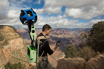
Trekking the Grand Canyon for Google Maps

Trekking the Grand Canyon for Google Maps | Machines Pensantes | Scoop.it

The term "street view" in Google Maps is continually getting stretched as the world's oceans, canyons, mountains and even cemeteries are being added to this ever-expanding database. 


No comment yet.