


 Your new post is loading...


One of the great things about Twitter is that it’s a global conversation anyone can join anytime. Eavesdropping on the world, what what!
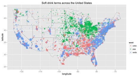
While many educators have been using http://popvssoda.com/ to show the linguistic regions in the United States, this is a similar map, with the added social media component. To map out these regions, the cartographer used the word choice on geo-tagged tweets as the data source. For another twitter, map, the following link shows which regions are most actively engaged on Twitter: http://www.huffingtonpost.com/2012/07/06/top-countries-on-twitter_n_1653915.html
What do these regions show us? What types of regions are these?
Seth: This is a fun site!
Via Seth Dixon


