Research and publish the best content.
Get Started for FREE
Sign up with Facebook Sign up with X
I don't have a Facebook or a X account
Already have an account: Login

ks3humanities
1.5K views |
+1 today


 Your new post is loading...
 Your new post is loading...
Your new post is loading...
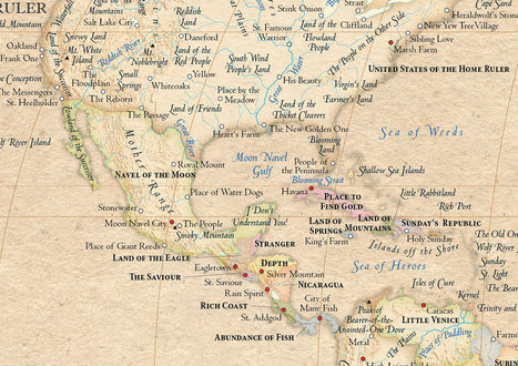
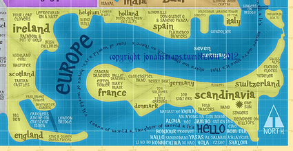
The Atlas of True Names reveals the etymological roots, or original meanings,
Carol Thomson's insight:
I loved looking at the map of great britain. I hope it grabs my pupils' attention as an introduction to maps. 

Kaylin Burleson's curator insight,
June 16, 2013 4:44 PM
What a good way to get the students thinking and questioning while using this fun set of maps.

John Blunnie's curator insight,
July 2, 2013 11:12 AM
True names give these maps a unique and historic twist. 
Amy Marques's curator insight,
July 31, 2013 7:19 PM
Great to see what the original names where! Especially for those that are similar to its current name and those that are completely irrelevant!
Ever since my first visit to to Disneyland, I was intrigued by the the ride 'It's a Small World After All." As a youngster, it was an opportunity to get in cool boat ride that I always regretted half way into the ride once the song was firmly chiseled into my mind. This blog post explores the curious and fascinating geographical imaginations, the visions of folk cultures and global harmony behind this Disneyland ride. This fabulous map charts that vision. I need to work out how to use this and I will.
|

The Esri Thematic Atlas is a configurable web application that uses a collection of intelligent web maps with text, graphics, and images to talk about our world.
Carol Thomson's insight:
First unit is based on maps and atlases. Want to build a range of resources.

JMSS_Geography Resources's curator insight,
June 26, 2013 1:20 AM
The Esri Thematic Atlas is a configurable web application that uses a collection of intelligent web maps with text, graphics, and images to talk about our world.
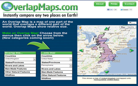
An OverlapMap is a map of one part of the world that overlaps a different part of the world. OverlapMaps show relative size.
The above overlap map is the United Kingdom compared to the state of Pennsylvania. This is an very simple way to demonstrate the true size of remote places, and 'bring the discussion home.' This site is as simple and intuitive as it is powerful and easily applicable. This is a keeper.
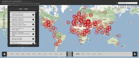
Browse the timeline of war and conflict across the globe.
This database of global wars and conflicts is searchable through space and time. You can drag and click the both the map and timeline to locate particular battles and wars, and then read more information about that conflict. This resource would be a great one to show students and let them explore to find what they see as interesting. This site is brimming with potential. Via Seth Dixon, Matthew Wahl

olsen jay nelson's comment,
August 16, 2012 7:46 AM
This is just what I've been looking for, believe it or not:-)

Paul Rymsza's comment,
August 22, 2012 2:15 PM
the potential of this site is amazing between the interactive learning system and the correlation between the timeline and location. If the human geography class is anything like this i can't wait for it!
|


In the Winnie the Pooh Movie Pooh's Grand Adventure, the character Rabbit has absolute confidence in the printed word and especially the map.
Questions to ponder: How much do we trust any given map? How much should we trust a map (or the printed word)? What makes a document reliable or unreliable?
The user is putting total trust in the map to get from A to B. How can we trust the map? What are the features of good infromation? A useful discussion-starter.
I think this video is a perfect example of todays modern soceity. Many people in this would today are exactly like rabbit, they believe everything they see without questioning its integrity. this has cause alot of problems in todays internet fueled world with anyone being able to post whatever they want and call it fact. This is where we need more people like Pooh who question everything. Pooh sees where he wants to go with his own eyes and can tell that rabbit is leading him the wrong way. This is relateable to so much in geography but to keep it simple ill compare it to Pythagoras proclaimed the earth was spherical. He question something everyone in the world took as a fact and nobody believed him because it was already stated that the world was flat. Just like pooh questioning the "offical map"