


The Esri Thematic Atlas is a configurable web application that uses a collection of intelligent web maps with text, graphics, and images to talk about our world.
Get Started for FREE
Sign up with Facebook Sign up with X
I don't have a Facebook or a X account


 Your new post is loading...
 Your new post is loading...
Your new post is loading...
The Esri Thematic Atlas is a configurable web application that uses a collection of intelligent web maps with text, graphics, and images to talk about our world.
Carol Thomson's insight:
First unit is based on maps and atlases. Want to build a range of resources. 
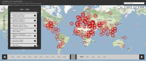
Browse the timeline of war and conflict across the globe.
This database of global wars and conflicts is searchable through space and time. You can drag and click the both the map and timeline to locate particular battles and wars, and then read more information about that conflict. This resource would be a great one to show students and let them explore to find what they see as interesting. This site is brimming with potential. Via Seth Dixon, Matthew Wahl

olsen jay nelson's comment,
August 16, 2012 7:46 AM
This is just what I've been looking for, believe it or not:-)

Paul Rymsza's comment,
August 22, 2012 2:15 PM
the potential of this site is amazing between the interactive learning system and the correlation between the timeline and location. If the human geography class is anything like this i can't wait for it!
|

By moving the slider, the user can compare 1990 false-color Landsat views (left) with recent true-color imagery (right). Humans are increasingly transforming Earth’s surface—through direct activities such as farming, mining, and building, and indirectly by altering its climate. This interactive feature includes 12 places that have experienced significant change since 1990. This is an user-friendly way to compare remote sensing images over time. Pictured above is the Aral Sea, which is and under-the-radar environmental catastrophe in Central Asia that has its roots in the Soviet era's (mis)management policies.
Tags: remote sensing, land use, environment, geospatial, environment modify, esri, unit 1 Geoprinciples, zbestofzbest.

Jake Red Dorman's curator insight,
November 13, 2014 2:25 PM
Clearly the water level has decreased in Kazakhstan from 1990 until now. Farming, mining, and building are all indirectly changing the geography of some places. The use of rivers for cotton irrigation has shrunk by 3 quarters in the last 50 years and it is extremely affecting the Aral Sea. 
Maria la del Varrio's curator insight,
December 13, 2014 3:10 PM
Is sad to see how humans are changing the environment forcing the wild creatures to abandon the places they've been living for hundred or years or die of starvation. I wonder what will happen in 300 years when there is no more big lakes and the oceans will be completed polluted . 
Tanya Townsend's curator insight,
November 20, 2015 2:57 PM
Great tool to show students how human use of natural resources can change landscapes and have permanent impacts on geographical landmarks such as the aerial sea. How do we stop it? Can we undo the damage done? How do we prevent these tragedies from happening in the future?
Geo-literacy extends far beyond knowing where places are on a map. National Geographic Education has put an emphasis on geoliteracy, which entails spatial thinking skills and understanding systems in addition to content knowledge about locations and places. Via Mr. David Burton, Matthew Wahl

Adam Lenaarts's curator insight,
September 30, 2013 6:33 PM
Geo literacy explained to all people that don't know I Teacher Much more than just places... 
Sandra Davies's curator insight,
May 15, 2020 8:11 AM
This is an important part of understanding geography - the geo-literacy.
|


The Esri Thematic Atlas is a configurable web application that uses a collection of intelligent web maps with text, graphics, and images to talk about our world.